Showing 27535 items
matching yarra-river
-
 Kew Historical Society Inc
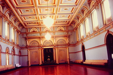
Slide - State Ballroom: Government House Victoria, John T Collins, 1979
Government House, Melbourne was constructed between 1972 and 1876 to a design of William Wardell. The interiors including the ballroom were created soon after the building's opening. The Victorian Heritage Register citation notes that the extravagant single storey State Ballroom occupies the entire south wing. The slide is significant as it represents the decoration of the State Ball Room in 1979.One of six colour transparencies, purchased from John T Collins of interior and exterior views of Government House, Melbourne. This photograph (slide) is of the State Ballroom."South Yarra Government House Ballroom J Collins 17-10-79"government house -- melbourne, victorian interiors, ballrooms -- melbourne (vic.), john t collins -
 Kew Historical Society Inc
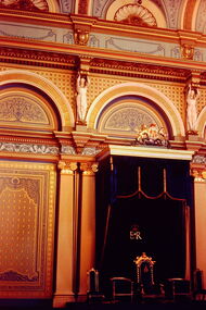
Slide - State Ballroom: Government House Victoria, John T Collins, 1979
Government House, Melbourne was constructed between 1972 and 1876 to a design of William Wardell. The State Ballroom is part of the 'State Apartments' which also includes the State Hall, State Drawing Room, State Dining Room and the Billiard Room.The slide is significant as it represents the ceiling decoration of the State Drawing Room in 1979.One of six colour transparencies, purchased from John T Collins of interior and exterior views of Government House, Melbourne. This photograph (slide) is of the throne in the State Ballroom."South Yarra Government House Throne J Collins 17-10-79"government house -- melbourne, victorian interiors, ballrooms -- melbourne (vic.), john t collins -
 Kew Historical Society Inc
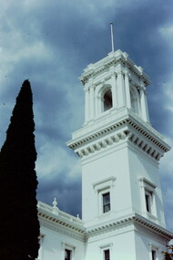
Slide - Tower: Government House Victoria, John T Collins, 1979
Government House, Melbourne was constructed between 1972 and 1876 to a design of William Wardell. The slide is significant as it represents the ceiling decoration of the State Drawing Room in 1979.One of six colour transparencies, purchased from John T Collins of interior and exterior views of Government House, Melbourne. This photograph (slide) is of the exterior of the tower."South Yarra Government House Tower J Collins 17-10-79"government house -- melbourne, john t collins -
 Kew Historical Society Inc
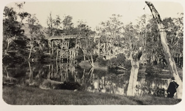
Photograph - Demolishing the Zig-Zag Bridge, 1929
Henry Beater Christian (1886-1962) , was a descendant of one of the earliest settler families in Kew. Employed at the Kew Asylum as a 'public servant', he was a skilled amateur photographer, photographing numerous scenes in Kew and on his travels around Victoria. The majority of his photographs date from 1916 to 1929. His finest photographs are housed in two photograph albums. Rare photograph of the demolition of the Zig-Zag Bridge linking the two asylums on either side of the Yarra River.Digital copy of a photograph from page 16 of the 47-page photograph album containing 261 gelatinous silver images, loaned by Diane Washfold with permission given to digitise and hold a copy in our collection. The Zig-Zag Bridge linked the grounds of the Yarra Bend and Kew Asylums. The wooden bridge was constructed in the 1870s and lasted through numerous floods until its destruction in 1929. A horizontal structure, the walkway was reached via a wooden staircase on the Kew bank of the river. The steps were required due to the different levels of the banks on this stretch of the river. This is a photo of the bridge before part of it was destroyed in a flood in 1929. A man, perhaps Henry Christian, stands at the right of the foreground."Demolishing Zig-Zag / 6. 1929"henry beater christian (1886-1962), landscape photography, kew (vic.) — yarra river, christian-washfold collection, photograph albums, zig-zag bridge -
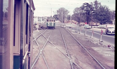 Melbourne Tram Museum
Slide - Set of 3, Keith Caldwell, March 1967?
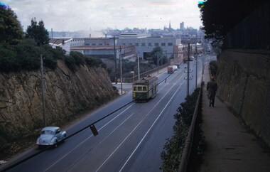
Set of three Agfa colour blue white plastic mount slides, photo by Keith Caldwell of : .1 - W2 651 outbound on route 15 to St Kilda beach negotiating trackwork at the St Kilda Junction. .2 - view from Upton Road overpass looking east at the Queensway road and tram track construction .3 - ditto, looking west shows the St Kilda Road bridge section being constructed c early, possibly March 1967.1 - "BXBU" and on .3, .1 also has "MBR River" in ink.trams, tramways, st kilda rd, st kilda junction, w2 class, route 15, trackwork, queensway, tram 651 -
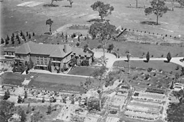 Greensborough Historical Society
Photograph - Digital Image, Amberley Mansion from the air 1930s, 1930s
An aerial view of Amberley Mansion in Lower Plenty, taken during the 1930s. Amberley was built in the 1920 as a private residence and later as a centre for Christian Brothers. Located on a bend in the Yarra River and now known as Edmund Rice Centre Amberley, it is currently a conference centre, school camp and function centre.An example of an early 20th century building that has survived for over 100 year, with variations to its use.Digital copy of black and white photographamberley, edmund rice centre amberley, christian brothers, lower plenty -
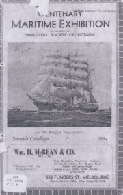 Mission to Seafarers Victoria
Booklet - Catalogue, Shiplovers' Society of Victoria, Centenary Maritime Exhibition, 1934
In 1934, the Shiplover's Society of Victoria organised an exhibition of 170 maritime artefacts, photographs and paintings on the barque Shandon berthed on the Yarra river to celebrate the Centenary of the foundation of Melbourne. The exhibition was opened on the 10th of October 1934 by the Lord Mayor, Sir Harold Gengoult Smith and ended on the 17th of March 1935. The catalogue lists all the items on display. The Jottings from our Logs from 1934 mentions that "should there be any surplus after expenses are paid, the Shiplovers has promise that (the Mission) shall benefit."Photocopies on A4 paper printed in BW of the catalogue held at the SLV.barque shandon, shiplovers' society of victoria, centenary, melbourne, centenary maritime exhibition, charles dickson gregory, george frederick gregory (1821-1887), ss bangalore -
 University of Melbourne, Burnley Campus Archives
Plan, Royal Horticultural Society's Garden
Changed boundaries of the site burnley gardens, survey paddock, flood, lynch design, richmond park, yarra river -
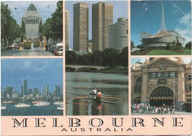 Melbourne Tram Museum
Postcard, Steve Parish Paddington Qld, Five views of Melbourne with trams, 1990
Postcard - full colour, Divided back type of six views of five views of Melbourne of St Kilda Road with trams, Rowing on the Yarra River with the city skyline in the background, The Arts Centre, Flinders St station and a view from Williamstown back to the CBD. Has title "Melbourne Australia" on the underside of the photos. Steve Parish production, 1990, produced in Paddington Qld. Has logo, position for stamp and address on the rear and number PC 308.trams, tramways, melbourne, shrine of remembrance, flinders st station, arts centre -
 Melbourne Tram Museum
Slide - Set of 2, John Webster, 14/06/1960 12:00:00 AM
Set of two Colour slides Kodak, white cardboard of trams: .1 - an SW6 (route 42) car descending the Barkers Road hill through the cutting towards Victoria Bridge over the Yarra river, Has the Vickers Ruwolt factor in the background and the city skyline. .2 - SW6 893 (City Route 42), crossing the Victoria Bridge after leaving the Barkers Road cutting. Shows the overhead support structure on the bridge. Slide datedHand writing on rear in ink "14-6-60 - Retrieving a trolley pole Church St Hawthorn."trams, tramways, route 42, barkers road, sw6 class, bridges, victoria bridge, tram 893 -
 Melbourne Tram Museum
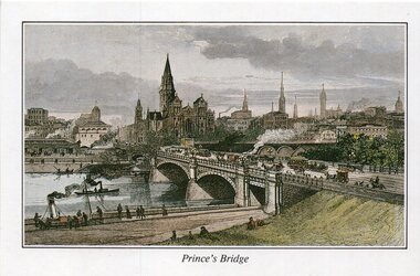
Drawing - Illustration, St Paul's Cathedral, "Engraving of Prince's Bridge and St Paul's Cathedral, Melbourne 1889", 1992
Illustration - colour engraving printed onto white card, titled "Princes Bridge" showing the planned St Paul's Cathedral, Flinders St Station, Princes bridge with cable trams and the Yarra River with steam powered boats. On rear - "Engraving of Prince's Bridge and St Paul's Cathedral, Melbourne 1889" with a note that it was drawn before the completion of the cathedral the design shows in that intended by the Architect, William Butterfield and that it was from the collection of St Paul's Cathedral.trams, tramways, yarra river, st pauls cathedral, melbourne, greetings cards -
 Port of Echuca
Colour Photograph, 04/03/1983
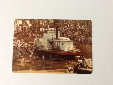
This coloured photograph shows the re-floating of the P. S. Adelaide on a soil ramp, being encouraged (rear entry) down the temporary slipway onto the river. The temporary slipway is clearly visible with a workman (possibly Kevin Hutchinson) standing at thelast log as the boat nears the waters' edge. A winching float and an outboard motor boat are at the right. Spectators line the banks of the ramp. Part of a photo sequence no.P000041; P000045; P000046; P000047; P000048 of P. S. Adelaide re-floating.The re-floating of the P. S. Adelaide was a Significant community social event evident by the number of spectators in the photograph. The community had invested a great deal of time and money into re-floating the paddlesteamer. The newspaper covered the event in detail with a number of action shots as the boat made its rear entry from the temporary slipway onto the river. Part of a photo sequence no.P000041; P000045; P000046; P000047; P000048 of P. S. Adelaide re-floating.Colour photograph of the P. S. Adelaide on a soil ramp, being encouraged (rear entry) onto the river. A winching float and an outboard motor boat are at the right front. Spectators line the banks of the ramp. Temporary slipway constructed of logs is clearly visible before the boat enters the water. -
 Sherbrooke Foothills Historical Society
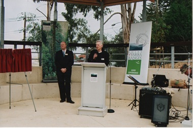
Belgrave Town Park Opening 30 July 2005
Colour Photographs of the opening of the Belgrave Town Park 30 July 2005. The guests included James Merlino, Member for Monbulk; Shire of Yarra Ranges Mayor Cr David Hodgett; Yarra Ranges Councillor Cr Robyn Hale; foundation member of the Sherbrooke Foothills Historical Society Ian Warburton.On verso each numbered and with the text " Belgrave Images" Undated -
Glenelg Shire Council Cultural Collection
Print - Contact Print - Pastoral Scene, 1960-1970
Sheet of 2 contact prints from glass plate negatives. Top: 2 men and 2 women in a clinker built dinghy on a river. Beds of reeds in river. River bank heavily wooded. Bottom: 3 women, one seated in garden at 'Beechwood', Dutton Way. People in both prints dressed in fashion late 19th, early 20th century. -
 Kiewa Valley Historical Society
Photos - Tawonga Bridge x 2
The first Tawonga bridge was built in 1884. It was destroyed by floods in 1916. The new bridge was constructed in 1923 and destroyed in 1953. The present concrete bridge was constructed in 1986 and named Ryders Bridge. Also refer to ?KVHS 0962 and KVHS 1051, KVHS 1090, KVHS 1123Bridge constructed over the Kiewa River in 1923 and destroyed in 1953.1. Dark Brownish photo framed by thin wood. Photo shows bridge with mountain behind and river and river bank in the foreground. 2. Small photo showing 2 sides of the bridge - a close up view.tawonga bridge, kiewa valley, kiewa river -
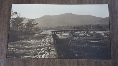
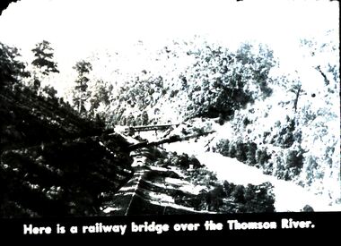 Bendigo Historical Society Inc.
Slide - DIGGERS & MINING. DIGGERS AND MINERS, c1850s
Diggers & Mining. Diggers and miners. Walhalla - Gold Town. Here is a railway bridge over the Thomas River. Picture shows the lush growth along the river. Markings: 26 995 WAL. Used as a teaching aid.hanimounteducation, tertiary, goldfields -
Whitehorse Historical Society Inc.
Article, Girl's bush survival tale inspires wonder, 2013
Fourteen year old girl lost in the Yarra Valley for three weeks in 1885.Fourteen year old girl lost in the Yarra Valley for three weeks in 1885, which was the inspiration for McCubbin's painting 'Lost'.Fourteen year old girl lost in the Yarra Valley for three weeks in 1885.mccubbin, frederick, crosby, clara -
Whitehorse Historical Society Inc.
Book, When the wattles bloom again, 1984
When the wattles bloom again : the life and times of William Barak, last chief of the Yarra Tribe, by Shirley W. WienckeWhen the wattles bloom again : the life and times of William Barak, last chief of the Yarra Tribe, by Shirley W. WienckeWhen the wattles bloom again : the life and times of William Barak, last chief of the Yarra Tribe, by Shirley W. Wienckebarak, william, aborigines -
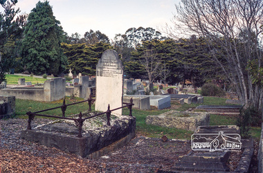 Eltham District Historical Society Inc
Negative - Photograph, Harry Gilham, Grave of Harriet Agrita Falkiner (1849-1923) , Eltham Cemetery, Victoria, Sep 2009
Harriet Falkiner was the daughter of Frederick Edward and Fanny Falkiner. Frederick was Eltham's first postmaster and settled in the district on the Diamond Creek and Yarra River around 1848 where he established an orchard and grazed cattle. The original family home was a pioneer settler's cottage built by Frederick Falkiner in Ely street.Roll of 35mm colour negative film, 6 stripsKodak GC 400-9alexander richard falkiner, eltham cemetery, evelyn falkiner, frederick edward falkiner, gravestones, harriet agrita falkiner -
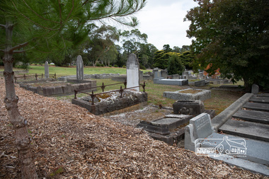 Eltham District Historical Society Inc
Photograph, Peter Pidgeon, Grave of Harriet Agrita Falkiner (1849-1923) , Eltham Cemetery, Victoria, 5 April 2021
Harriet Falkiner was the daughter of Frederick Edward and Fanny Falkiner. Frederick was Eltham's first postmaster and settled in the district on the Diamond Creek and Yarra River around 1848 where he established an orchard and grazed cattle. The original family home was a pioneer settler's cottage built by Frederick Falkiner in Ely street.Born Digitaleltham cemetery, gravestones, heritage excursion, alexander richard falkiner, evelyn falkiner, frederick edward falkiner, harriet agrita falkiner -
 Kew Historical Society Inc
Plan, Studley Park Estate, 1910
Prue Sanderson, in her groundbreaking ‘City of Kew Urban Conservation Study : Volume 2 - Development History’ (1988), summarised the periods of urban development and subdivisions of land in Kew. The periods that she identified included 1845-1880, 1880-1893, 1893-1921, 1921-1933, 1933-1943, and Post-War Development. These periods were selected as they represented periods of rapid growth or decline in urban development. An obvious starting point for Sanderson’s groupings involved population growth and the associated economic cycles. These cycles also highlighted urban expansion onto land that was predominantly rural, although in other cases it represented the decline and breakup of large estates. A number of the plans in the Kew Historical Society’s collection can also be found in other collections, such as those of the State Library of Victoria and the Boroondara Library Service. A number are however unique to the collection.The Kew Historical Society collection includes almost 100 subdivision plans pertaining to suburbs of the City of Melbourne. Most of these are of Kew, Kew East or Studley Park, although a smaller number are plans of Camberwell, Deepdene, Balwyn and Hawthorn. It is believed that the majority of the plans were gifted to the Society by persons connected with the real estate firm - J. R. Mathers and McMillan, 136 Cotham Road, Kew. The Plans in the collection are rarely in pristine form, being working plans on which the agent would write notes and record lots sold and the prices of these. The subdivision plans are historically significant examples of the growth of urban Melbourne from the beginning of the 20th Century up until the 1980s. A number of the plans are double-sided and often include a photograph on the reverse. A number of the latter are by noted photographers such as J.E. Barnes.Coloured lithograph of a subdivision plan of the Studley Park Estate, bordered by Yarra, Willsmere Road and the Outer Circle Railway line. The estate was listed in 1910 and was the subject of a planning dispute between the developer and the Town of Kew in relation to flood levels and the suitability of the land for housing. In many cases the names of streets were subsequently changed. The layout was also affected by the creation of the Eastern Freeway. A newspaper report of the day described the subdivision as a: "GOLDEN OPPORTUNITY. We are pleased to submit for PRIVATE SALE that magnificent ESTATE, situated only 4 1/2 miles from the Melbourne General Post Office, STUDLEY PARK ESTATE. KF/NV. Doubtless the CHEAPEST LAND EVER OFFERED having extensive frontages to the prettiest spot on the River Yarra and the National Park, commanding lovely river and landscape views, and acknowledged to be the finest land available so close to the city. The PRICES ARE EXTREMELY MODERATE; The TERMS ARE SIMPLY MARVELLOUS. NO DEPOSIT. NO DEPOSIT. NO DEPOSIT. Allotments and prices to suit everyone."subdivision plans - kew, studley park estate -
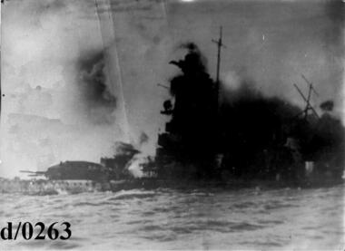 Waverley RSL Sub Branch
Photo The Admiral Graf Spee
Photo taken by a sailor onboard H.M.S.Ajax 17 Dec.1939 On December 17, 1939 the Admiral Graf Spee, with Langsdorff and a skeleton crew of 40 aboard, steamed out of Montevideo as 20,000 onlookers watched. The crew set the scuttling charges and and everyone was evacuated by an Argentinian tugboat. The explosions ripped through the ship and it sank at 08:55 PM. On December 20, Captain Langsdorff, lying on the ship's flag and wearing his full dress uniform, shot and killed himself.Black and white photo of The Admiral Graf Spee being scuttled in the Pate Rivergraf spee -
Glenelg Shire Council Cultural Collection
Negative - Negative - View of Glenelg River, 1934
Part of a collection of photographs taken by Zillah Maschmedt in 1934. She was a teacher from South Australia.Negaative for black and white photo. View of the Glenelg River near Nelson, Victoria. -
Glenelg Shire Council Cultural Collection
Negative - Negative - Glenelg River, Nelson, Victoria, c. 1936
Transparency for a black and white photo. View of the Glenelg River near Nelson, Vic -
Glenelg Shire Council Cultural Collection
Negative - Negative - Glenelg River, Nelson, Victoria, c. 1936
Transparency for black and white photo. Glenelg river at Nelson, Vic, looking upstream -
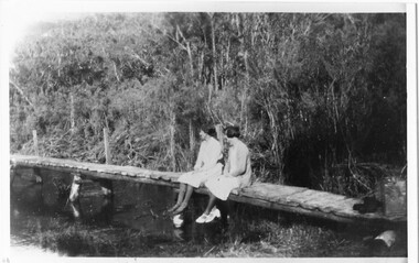 Halls Gap & Grampians Historical Society
Photograph - B/W
Photo shows 2 women sedated on wooden footbridge over the Wannon riverstructures, bridges -
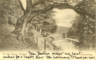 Federation University Historical Collection
Postcard - black and white, On the Lagan, Belfast, c1900, c1900
WW1 Holmes Family souvenirAustralian WW1 soldier's souvenirTwo black and white postcards of a treed scene with river. It is the Lagan, Belfast, Irelandchatham-holmes family collection -
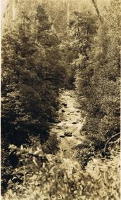 Bendigo Historical Society Inc.
Photograph - BLACK AND WHITE PHOTOGRAPH OF MURRAY'S PASS GULLY MARYSVILLE
Black and white photograph of Murray's Pass, aggerty River, Marysville, 1924-25.photograph, landscape -
 Bendigo Historical Society Inc.
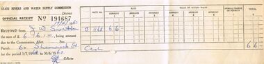
Document - J W SWATTON COLLECTION: STATE RIVERS AND WATER RECEIPT
Receipt No. 194687 from the State Rivers and Water Supply Commission for £6/6/-.person, receipts, j w swatton, j w swatton collection, state rivers and water supply commission -
 Bendigo Historical Society Inc.
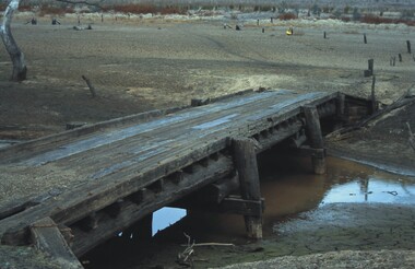
Slide - VAL DENSWORTH COLLECTION: DRY LAKE EPPALOCK, May 2004
Slide. Dry Lake Eppalock. A Small wooden bridge over the river in the Lake.slide, bendigo, dry lake eppalock., dry lake eppalock.