Showing 10390 items
matching plan
-
 Bendigo Historical Society Inc.
Document - VICTORIA HILL - VICTORIA HILL AND NEW CHUM HILL
Typed notes on Victoria Hill and New Chum Hill. Notes give location, value of gold and plans for a mining museum.document, gold, victoria hill, victoria hill, victoria hill and new chum hill, john neil macartney, the age, the australasian, bendigo goldfields registry 1871, victoria reef quartz mine, north old chum, victoria consols, new chum and victoria, pioneer, lansell 222 mine, lazarus, barnet lazarus, mt. alvernia hospital, fortuna villa, george lansell, a. h. q. survey regiment, central red white and blue, hudsons, burrowes & sterry, b c v channel 8, bendigo and district tourist association, section 14 of the lands act 1958, mr a r richardson, cr t r flood, tourist association -
 Bendigo Historical Society Inc.
Document - MCCOLL, RANKIN AND STANISTREET COLLECTION: NORTH MONUMENT
Documents: Manilla folder - Plan of area applied for on lease No. 10023 Ben. Prospectus of the Monument Hill Gold Mining Company.MCCOLL RANKIN & STANISTREETorganization, business, gold mining lease, mccoll rankin & stanistreet -
 Bendigo Historical Society Inc.
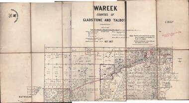
Map - JACK FLYNN COLLECTION: WAREEK, Examined 1918
Map: L.1053. Parish of Wareek, Counties of Gladstone and Talbot. Parish plan. Looks like half of the sheet is missing.Second Issue. Examined by S.F. Green. July 1918. William J. Swan, Draughtsman, August 1884. Photo-Lithographic Fac-Simile, W 36.map, gladstone, parish plan, wareek -
Bendigo Historical Society Inc.
Map - PART PARISHES OF SANDHURST MARONG AND NERRING, No date visible
Map: Section of a Parish plan of Bendigo, covering Ironbark, Eaglehawk and Myers Flat ( number 145 in Map Cupboard 1)map, bendigo, city streets, parish of sandhurst, parish of marong, parish of nerring, ironbark, eaglehawk, myers flat -
Bendigo Historical Society Inc.
Map - BENDIGO IRRIGATION SETTLEMENT, 12/02/1908
Map: Plan of Bendigo Irrigation Settlement, Parishes of Sandhurst and Wellsford, County of Bendigo ( number 160 in Map Cupboard 1)map, bendigo, irrigation settlement, bendigo irrigation settlement, parishes of sandhurst and wellsford, county of bendigo -
Bendigo Historical Society Inc.
Map - EPSOM ?, Circa 1880
Map: Parish plan showing an area Southwards from the parish of Huntly boundary, Covering Epsom,Ascot and White Hillsmap, bendigo, parish plan, epsom, ascot, white hills -
Bendigo Historical Society Inc.
Map - TOWNSHIP OF KANGAROO FLAT, 27/01/1932
Map: Township of Kangaroo flat, Parish of Sandhurst , County of Bendigo. Parish plan ( number 194 in Map Cupboard 1)map, bendigo, township, kangaroo flat -
Bendigo Historical Society Inc.
Map - BOROUGH OF EAGLEHAWK, 30/11/1931
Map: Borough of Eagle hawk, Parish of Nerring. Parish plan with coloured areas ( number 185 in Map Cupboard 1)map, bendigo, parish plan, borough of eaglehawk, parish of nerring -
Bendigo Historical Society Inc.
Map - NEW CHUM LINE, 1875
Plan: Longtitudinal section of the Southern Section of the New Chum Line of Reef. Compilation consisting of small sections stapled togetherCALEB THOMAS 1875map, mining plan, gold mines, new chum line -
Bendigo Historical Society Inc.
Map - NEW CHUM LINE, 1875
Plan: Longtitudinal Section of the Northern Section of the New Chum Line of Reef. Compilation consisting of smaller sections stapled togethermap, new chum line, gold mines, new chum line of reef -
Bendigo Historical Society Inc.
Map - TARNAGULLA (PARTS), Circa 1880's
Map: Compilation of 3 hand draughted parish plans showing portions of Tarnagulla (number 261 in map cupboard 1)map, parish plan, tarnagulla -
Bendigo Historical Society Inc.
Map - TOWNSHIP OF HEATHCOTE (PART), 11/04/1935
Map: Township of Heathcote (part), Parish of Heathcote, County of Dalhousie. Parish plan (number 259 in map cupboard 1)map, dalhousie, township, heathcote, copunty of dalhousie -
Bendigo Historical Society Inc.
Map - HUNTLY (PART) RESURVEY, Circa 1877
Map: Huntly [part) resurvey, Parish of Huntly, County of Bendigo. Parish plan ( number 243 in Map Cupboard 1)map, bendigo, parish plan, huntly -
Bendigo Historical Society Inc.
Map - PARISH OF EPPALOCK RESURVEY, 23/05/1876
Map: Parish of Eppalock resurvey, County of Bendigo, hand draughted Parish plan ( number 240 in Map Cupboard 1)map, bendigo, parish plan, eppalock, resurvey -
Bendigo Historical Society Inc.
Map - SANDHURST (PART), Circa 1880's
Map: Parish plan showing the area Specimen Hill Road and Inglewood St. ( number 222 in Map Cupboard 1)map, bendigo, parish plan, specimen hill rd. inglewood st. -
 Bendigo Historical Society Inc.
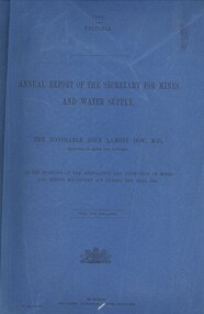
Book - ANNUAL REPORT OF THE SECRETARY FOR MINES AND WATER SUPPLY, c1886
Annual Report Of The Secretary For Mines And Water Supply, Victoria. Publisher: Government Printer, Melbourne. 122 pages. Plans & drawings.victoria, mines and water supply, mining machinery, mine safety, mining statistics, regulation inspection 1885 -
Bendigo Historical Society Inc.
Map - WESTON, 21/10/1876
Map: Re-Survey of part of the parish of Weston, County of Rodney. Parish plan (number 309 in map cupboard 1)Murray and Hargreave, Authorised surveyorsmap, rodney, parish plan, parish of weston, murray and hargreave -
Bendigo Historical Society Inc.
Map - METCALFE, 30/10/1878
Map: Metcalfe, County of Dalhousie. Parish plan (also has a smaller addition glued onto the right hand side)map, dalhousie, parish plan, metcalfe -
Bendigo Historical Society Inc.
Map - BENDIGO, October 1st 1893
Map: Plan of the whole County of Bendigo, Showing areas now available for Selection (number 340 in map cupboard 1)map, bendigo, lands for selection, county of bendigo, areas available for selection -
Bendigo Historical Society Inc.
Map - GRAZING ALLOTMENTS, 15/10/1894
Map: Grazing Allotments, Parishes of Whirrakee and Bagshot, County of Bendigo. Parish plan (number 331 in map cupboard 1)map, bendigo, grazing allotments, grazing allotments, whirrakee, bagshot -
National Vietnam Veterans Museum (NVVM)
Document, Printed email from Russell Morris to Wendy Anderson (NVVM), 2014
Russell gave Wendy permission to play a digital version of the song, "Rachel" in a planned display that reflects the views of protesters in the museumvietnamese conflict, 1961-1975 - protest movements - australia, morris, russell -
Tatura Irrigation & Wartime Camps Museum
Sketch, Carl Kubler, 1937
Brown wooden framed, blue/grey mat, pencil drawing of plan of Sarona featuring streets and houses, fields and plantations.Sarona Deutsche Kalone Jaffa Palaestine Januar 1937 Prod Von Carl Kublercarl kubler, camp internee sketches, sarona palestine, magdalen kubler -
University of Melbourne, Burnley Campus Archives
Document, Ellis Stones, 1999-2000
Notes, correspondence and plan re Ellis Stones and on FOBG winning award to restore Ellis Stones dry water courseellis stones, fobg -
Lakes Entrance Regional Historical Society (operating as Lakes Entrance History Centre & Museum)
Book, Regional Coordination Group and Strategy Steering Committee, The East Gippsland Planning and Development Strategy, 1997
An outline of planning and proposed development by the East Gippsland, Victoria, Shire Council from 1997 to the year 2010. Maps included.township, land settlement, tourism -
Clunes Museum
Document - PLAN OF MINE, RIP VAN WINKLE GOLD MINING CO
PLAN OF RIP VAN WINKLE G M CO 1889 MINE ON NORTH SLOPE OF MOUNT GREENOCK VIA TALBOTEJ. SEMMENS CRESWICKlocal history, document, mining, mining, plans -
 Stawell Historical Society Inc
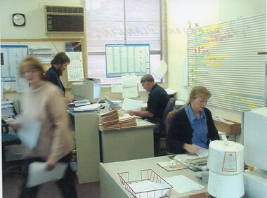
Photograph - Aunde Album 29, Production Planning, 2002
Aunde / Norwellan Textiles North Western Woolen Mills became Norwellan Textiles then AUNDEColour landscape photo: Office, 2 Women, 2 Men, planning calanders, file, computers, clock 1.50 PM.AUnde Australia Ltd. logoindustry, aunde -
Stawell Historical Society Inc
Map, Underground Mine Workings Stawell, 1894
Plan and Elevations of mine workings 12 September 1894. J H Bate Mining Surveyor. Framed under Glassstawell, mining, plans -
Whitehorse Historical Society Inc.
Article, Public to be given say in development, 1994
Residents have applauded a recommendation to council to defer a planned development at Campbells Croft / Abbey walk (photo: Yvonne Snape)Residents have applauded a recommendation to council to defer a planned development at Campbells Croft / Abbey walk (photo: Yvonne Snape)Residents have applauded a recommendation to council to defer a planned development at Campbells Croft / Abbey walk (photo: Yvonne Snape)city of nunawading, campbells croft, abbey walk, vermont, marnell, brian, snape, richard, snape, yvonne -
 Whitehorse Historical Society Inc.
Article, Developing an understanding, 10/05/1998 12:00:00 AM
suburban planning and developmentArticle by Peter Seamer, Whitehorse City Council C.E.O. on suburban planning and development in 'The Sunday Age' 10 May 1998. suburban planning and development land use, local government, city of whitehorse, seamer, peter -
 Whitehorse Historical Society Inc.
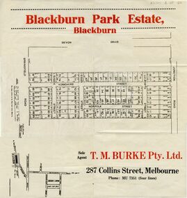
Document, Blackburn Park Estate, n.d
Land Sale plan for 'Blackburn Park Estate'Land Sale plan for 'Blackburn Park Estate' between Springfield and Junction Roads. Agent T.M. Burke Pty Ltd.Land Sale plan for 'Blackburn Park Estate'blackburn park estate, blackburn north, springfield road, junction road, sussex street, essex street, yorkshire street, lulworth street, norfolk street