Showing 11115 items
matching planning
-
 Canterbury History Group
Ephemera - 2a Willow Grove Canterbury, [1997]
Real estate advertisement for the sale by auction of 2a Willow Grove Canterbury on 15 November [1997].ncludes a sketch of the exterior of the building and floor and site plans.canterbury, willow grove -
Canterbury History Group
Ephemera - A stunning Victorian vision, [2002
Real estate advertisement for the sale of 35 Chatham Road Canterbury on 21 December 2002. Includes coloured photographs of the exterior and interior, and a plan of the layout of the house.canterbury, chatham road, victorian style, architectural features -
Canterbury History Group
Ephemera - 14 Compton Street Canterbury, [2001]
Real estate advertisement for the sale by auction of 14 Compton Strreet Canterbury on Saturday 30 June [2001] Includes a sketch of the exterior of the house and a floor plan.canterbury, compton street, edwardian style -
Canterbury History Group
Ephemera - 3 Dryden Sreet Canterbury, [2002]
Real estate advertisement for the sale by auction of 3 Dryden Street Canterbury on 16 March [2002]. Includes a sketch of the exterior of the house Includes a floor plan.canterbury, dryden street, timber houses -
Canterbury History Group
Ephemera - 7 Cross Street, Canterbury, c 2009
Real estate advertisement for the sale of "Rosemont" 7 Cross Street Canterbury on 21 November [2009] Includes several coloured photogarphs and floor and site plans.canterbury, rosemont, cross street, victorian style, stained glass, cast iron work -
Canterbury History Group
Ephemera - 186 Prospect Hill Road Canterbury, 1/12/2002 12:00:00 AM
Real estate advertisement for the auction of 186 Prospect Hill Road Canterbury on 7 December 2002. Includes coloured exterior photographs and floor and site planscanterbury, prospect hill road, swimming pools, tennis courts -
Friends of Ballarat Botanical Gardens History Group
Work on paper - Plans for Fencing the Ballarat Botanical Gardens, 2002, Problems With Vandalism and Theft, March, 2003
Fencing of Ballarat Botanical Gardens, because of problems with vandalism and theft. The reasons for the fencing of the Botanical Gardens are stated along with the aim to have the fencing appropriate to the style of the Gardens.2 pages. p.2 has plans on both sides of the page. Wendouree Parade fencing, p.2 and Proposed Fencing Scheme, p.3.The three pages have the Begonia logo in black and white with Ballarat Botanical Gardens superimposed and by Lake Wendouree below in smaller print.john garner collection, garner, dr, fence, vandalism, ballarat botanical gardens, ballarat, gardens, theft, proposed fencing scheme, wendouree parade fencing, elevation detail, adam parrott, ballarat city council, local law no.6, south gardens boundary, lych gates, elevation detail. -
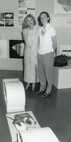 Lakes Entrance Historical Society
Photograph, Lakes Post Newspaper, 1996
Black and white photograph showing Jennifer North and Tobi Pederson standing in front of the display for Gondwanaland, Bullock Island, concept plan, Lakes Entrance Victoriaeducation -
Lakes Entrance Historical Society
Book, Tract Consultants Australia Pty Ltd, Storth Ryes Enviornment Effects Statement, 1988
Environment effects statement, Supplementary Report on the proposed Storth Ryes, Metung, Victoria, residential and resort development on the Gippsland Lakes. Includes concept plans and sketches.land settlement, commercial development -
University of Melbourne, Burnley Campus Archives
Plan, St James Park Feature Plan, 1983
City of Hawthorn Plan, drawing No P24/19, Sheet 1 of 1. Surveyed by L.B. & H.K. Traced by H.K. Aug 83. Scale 1:500.st james park, city of hawthorn, central gardens hawthorn -
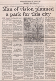 Bendigo Historical Society Inc.
Newspaper - NEWSPAPER COLLECTION: BENDIGO ADVERTISER 1993
Bendigo Advertiser from Thursday, April 29, 1993. Article by David G. Horsfall titled ''Man of vision planned a park for this city'' on Frank McDonough.newspaper, bendigo advertiser, various articles -
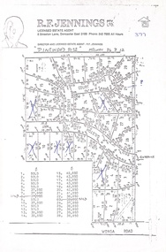 Ringwood and District Historical Society
Document, Land Sale Map and Price List - Pinewood Rise Subdivision, Ringwood, Victoria - (Undated, circa 1988)
Single page black & white photocopy of subdivision plan showing layout of 28 residential allotments with inset showing price list & some marked 'sold'.Director and Licensed Estate Agent - R.F. Jennings Pty Ltd., 8 Streeton Lane, Doncaster East 3109. Phone 842 7666 all hours. -
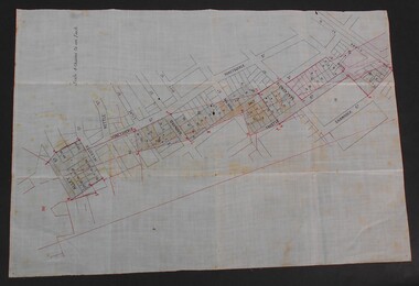 Bendigo Historical Society Inc.
Document - WES HARRY COLLETION: SURVEORS MAP ON LINEN OF HONEySUCKLE AND THISTLE STREETS
A surveyor's map to scale 4 chains to 1 inch of Honeysuckle & Thistle Streets, between Alley Street and Clark Street Unknown purpose of the plan - undated -
University of Melbourne, Burnley Campus Archives
Plan, Ratio Consultants Pty. Ltd, Conceptual Subdivision & Garden Layout Plan Project 'Rosecraddock' Rosecraddock Place Caulfield, 1991
Tracing paper plan by Ratio Consultants Pty. Ltd., for Mr P. Shellard, Project No 1887, drawing No LS3, October 1991. Scale 1:250.p. shellard, caulfield, ratio consultants, "rosecraddock", subdivision plans, landscape design -
Bendigo Historical Society Inc.
Map - PLAN OF VICTORIA HILL AREA, 1971
BHS CollectionBendigo Historical Society feature Plan of the Victoria Hill area. Printed on Paper. B & W. Compiled by AHG Survey Regiment.CMF Increment May 1971bendigo, gold mining, victoria hill -
Bendigo Historical Society Inc.
Map - PLAN OF VICTORIA HILL AREA, 1971
BHS CollectionBendigo Historical Society feature Plan of the Victoria Hill area. Printed on Acetate. B & W. Compiled by AHG Survey Regiment.CMF Increment May 1971bendigo, gold mining, victoria hill -
Canterbury History Group
Document - Frognall - History, Royal Australian Air Force
Photocopy of a 38 page booklet compiled by Royal Australian Air Force Engineers Cadet Squadron , includes maps, house floor plan, photographs and footnotescanterbury, royal australian air force engineers cadet squadron, hicks> clarence, laycock> burdett, frognall, mont albert road, maps, elgar's special survey -
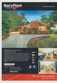 Whitehorse Historical Society Inc.
Plan - Residential Building Documents, Drayton and Colman, 1962 Building Documents For the Scambler House in Blackburn, 1962
1962 plans, interior drawings and specifications for G. Scambler's brick house at 16 Wolsley Crescent, Blackburn, and the 2013 Barry Plant Real Estate flyer. The architect was Drayton and Colman.1962 plans, interior drawings and specifications for G. Scambler's brick house at 16 Wolsley Crescent, Blackburn, and the 2013 Barry Plant Real Estate flyer. non-fiction1962 plans, interior drawings and specifications for G. Scambler's brick house at 16 Wolsley Crescent, Blackburn, and the 2013 Barry Plant Real Estate flyer. The architect was Drayton and Colman.scambler gk, drayton & colman architects, wolsley crescent -
 Bendigo Historical Society Inc.
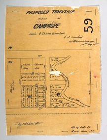
Map - PROPOSED TOWNSHIP PARISH OF CAMPASPE, 24th May 1875
Map: Proposed Township, Parish of Campaspe(This has been crossed out and 'Creek View' written above). Hand Draughted Parish plan Stapled to the backingmap, township, proposed township, campaspe, creek view -
Lakes Entrance Historical Society
Book, Bombala and Districts Historical Society, Backyard History, 1993
A history of Bombala Shire New South Wales and district from official records parish plans, and anecdotes, produced for research purposes only. Illustrated with maps.settlers, township, genealogy -
Lakes Entrance Historical Society
Book, Orbost Historical Society Inc, Barns of the Snowy River Orbost, 2006
Documents the distinctive slatted barns of the Lower Snowy River, Orbost, Victoria. Includes sketch maps, barn plans, history of area and families and personal ineterviews.Ngaire Donald May Leatchland settlement, agriculture, natural disasters, transport -
 University of Melbourne, Burnley Campus Archives
Plan, Border Next to Staff Car Park, c. 1980
(1) Rough hand drawn plan in pencil and biro of area between pergola and roadway to Library opposite Roundabout Lawn. (2) Photocopy of main portion.pergola, library, burnley horticultural college, border garden, driveway -
 Lakes Entrance Historical Society
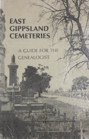
Book, Gibson, Tim, Monumental Bairnsdale Cemetery Memories, 1996
A guide to Bairnsdale Cemetery, Victoria, including a plan of the layout, a short history of its development, and genealogical notes of some of the remarkable people buried since commencement.cemeteries, social history, land settlement, memorials -
 Phillip Island and District Historical Society Inc.
Booklet, Cowes McRae Beach Estate, 1960s
This land was owned by the McRae family, whose wife was a Justice. Hence the street names of McRae and Justice. The weatherboard family home [ originally a guest house called Glen Isle] was at the end of the current Justice Road. The estate was created in the mid 1960s. The house was put on skids and dragged by two tractors and a bulldozer to 364 Church Street while the family home was built at 368 Church Street, Cowes.[ Source Sandra Rocotas, nee McCrae. Facebook Community Noticeboard 5/2/2023. Permission given to use information and photos ] Estate was sold by Rogan Real Estate.HistoricalColoured A4 brochure describing the McRae Beach Estate, including plan of streets and location on Island, photos and description of the Island. Sold by Rogan Real Estate.Cowes McRae Beach Estate - Right in the heart of things .Phillip Island - The Loveliest Isle on Earthhousing, justice family, mcrae family, cowes west, rogan real estate cowes phillip island, glen isla -
University of Melbourne, Burnley Campus Archives
Plan, Plan of the Melbourne Botanic Gardens, 1948
Partially coloured plan on a grid. Prepared from Field Notes of Survey by F.C. Ridoutt drawn and reproduced at the Dept. of Lands & Survey, Melbourne, March 1948.f.c. ridoutt, gardens, melbourne, royal botanic gardens melbourne -
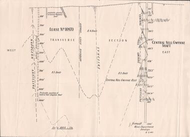 Bendigo Historical Society Inc.
Plan - Mining Lease No. 10970, April, 2014
One page plan of Lease No. 10970, showing Napoleon Anticline and Central Nell Gwynne Shaft. Prepared by J. Caldwell, Mines Department Bendigo 6.2.1940.goldmining, quartz, mining, central nell gwynne gold mine, napoleon reef -
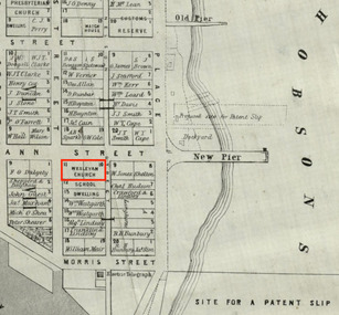 Mission to Seafarers Victoria
Map, Surveyor General's Office, Plan of Williamstown, County of Bourke, 20 November 1855
Plan of Williamstown in 1855The map helps locate the Wesleyan church on Ann Street which was converted in the Sailors' Rest in 1875.ann street, wesleyan church, sailors' rest, williamstown -
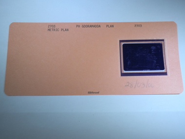 Rutherglen Historical Society
Aperture Card microfilm, Victorian Land Tiltes Office, Parish Plan Gooramadda, 28/03/2000
Parish Plan of Gooramaddacard with a single microfilm insertplan, lots, roads, boundary -
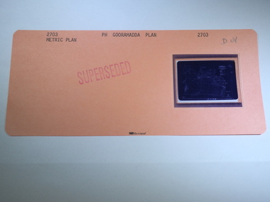
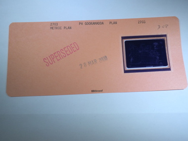 Rutherglen Historical Society
Aperture Card microfilm, Victorian Land Tiltes Office, Parish Plan Gooramadda (Superseded), 28/03/2000
Parish Plan of Gooramaddacard with a single microfilm insertplan, lots, roads, boundary -
 Rutherglen Historical Society
Aperture Card microfilm, Victorian Land Tiltes Office, Parish Plan Gooramadda (Superseded)
Parish Plan of Gooramaddacard with a single microfilm insertplan, lots, roads, boundary