Showing 25665 items
matching plenty-township-estate
-
 Bendigo Historical Society Inc.
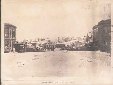
Photograph - WES HARRY COLLECTION: TOWNSHIP OF EAGLEHAWK, C. 1860's
Sepia photograph of the Township of Eaglehawk, looking down the hill from about Victoria St. Visible are the Victoria Hotel and the Exchange Hotel on the left hand side of the photo. At the bottom of the hill there is the old Town Hall and in the distance on the hill is one of the Virginia Reef mines.place, eaglehawk, streetscape, eaglehawk, victoria hotel, exchange hotel, virginia reef -
 Bendigo Historical Society Inc.
Map - REDESDALE, See above
Map: two maps on either side of backing, (1) Township of Redesdale, Parish of Redesdale. (2) Surban lands, Parish of Spring Plains, County of Dalhousie. Date are 26th May 1873 and 12/07/1909 ( number 157 in Map Cupboard 1)map, dalhousie, township, redesdale, parish of spring plains, county of dalhousie -
Tatura Irrigation & Wartime Camps Museum
Book, Girgarre Living History, Girgarre. Girgarre Living History, 2016
Girgarre - an extraordinary history, closer settlement, soldier settlement and family stories.Tells of the history of Girgarre, with information obtained from a collection of stories and extensive research into the Closer and Soldier Settlement of the districtRectangular shaped book ,aerial photo of the township and environs of Girgarre, on Market Day, September 2013. Photo extends over front & back covers, highly colourful cover. 251 pages. B/W photos and maps of local families and local scenes.girgarre, family histories, soldier settlement -
Tatura Irrigation & Wartime Camps Museum
Book, Girgarre Living History, Girgarre. Girgarre Living History, 2016
Girgarre - an extraordinary history, closer settlement, soldier settlement and family stories.Tells of the history of Girgarre, with information obtained from a collection of stories and extensive research into the Closer and Soldier Settlement of the districtRectangular shaped book ,aerial photo of the township and environs of Girgarre,on Market Day, September 2013. Photo extends over front & back covers, highly colourful cover. 251 pages ,B/W photos and maps of local families and local scenes.girgarre, family histories -
 Lakes Entrance Regional Historical Society (operating as Lakes Entrance History Centre & Museum)
Postcard, 1945c
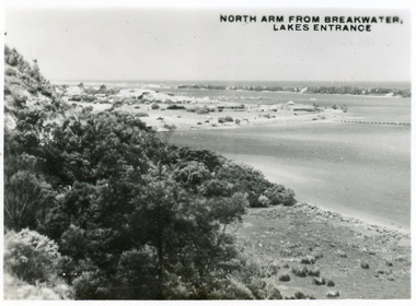
One other copy same sizeBlack and white small format postcard of the entry to the North Arm, taken from Jemmys Point. It shows a steep cliffside above the calm waters, township of Lakes Entrance and Cunninghame Arm, and sand hummocks of southern shore in distance. Lakes Entrance VictoriaNorth Arm from Breakwater - Lakes Entrancetownship, waterways, topography -
 Lakes Entrance Regional Historical Society (operating as Lakes Entrance History Centre & Museum)
Photograph, 1900c
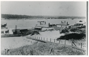
Also four other black and white copies, one size 12 x 18 cm, two size 9 x 14 cm, and one size 10 x 15 cm, one of which was purchased from Helen ClothierBlack and white photograph showing buildings on dunes, and township of Lakes Entrance across lake, Cunninghame Arm. Buildings from left are school, harbour masters house, harbour engineer's house. Boardwalk in foreground. Kalimna Hill in background. Lakes Entrance Victoriawaterways, vegetation, topography, township -
 Lakes Entrance Regional Historical Society (operating as Lakes Entrance History Centre & Museum)
Photograph, Phillips, Miss L, 1900c
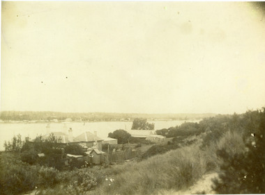
Also other black and white copy 9 x 14 cm, donated by Russell Goff with inscription The TownSepia photograph showing view from the dunes across lake, and Cunninghame Arm, to township. Foreground shows dense vegetation on dunes behind two houses, harbour engineer's house on left and contractor John Carpenter's house on right. Lakes Entrance Victoriawaterways, township, boats and boating, topography -
 Lakes Entrance Regional Historical Society (operating as Lakes Entrance History Centre & Museum)
Postcard, 1998c
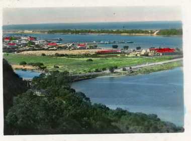
Tinted small format postcard showing the township situated on the isthmus between two stretches of water the Cunninghame Arm and the North Arm. Work in progress widening the North Arm Bridge as seen by workmen's huts beside the southern approach. Lakes Entrance Victoriajetties, waterways, topography, township -
 Lakes Entrance Regional Historical Society (operating as Lakes Entrance History Centre & Museum)
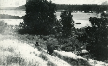
Photograph, 1910c
One other copyBlack and white photograph of the township, taken from the hummocks. It shows a person sitting under a black umbrella on a sand hill in the foreground, Cunninghame Arm, two persons in rowboat on water, buildings along Esplanade, Kalimna Heights in background. Lakes Entrance Victoriatopography, waterways -
 Lakes Entrance Regional Historical Society (operating as Lakes Entrance History Centre & Museum)
Postcard, 1920c
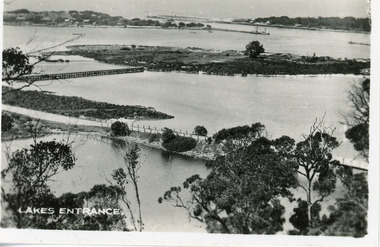
1 x Faded miniature postcard 6.5 x 8.5|1 x Black and white 9.5 x 12 copied from album in private hands|1 x Sepia toned 10 x 15|1 x Black and white 12 x 17.5Black and white small format postcard of Bullock Island. It shows the approaches to the concrete North Arm Bridge over North Arm, the footbridge to Bullock Island, the entrance to the Gippsland Lakes from Bass Strait and part of the township on the hummocks. Lakes Entrance VictoriaLakes Entrancewaterways, topography, islands, jetties -
 Lakes Entrance Regional Historical Society (operating as Lakes Entrance History Centre & Museum)
Photograph, Holding M, 2000c
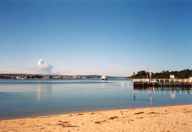
Colour photograph of the township viewed from the southern shore of Cunninghame Arm at the New Works. New Works Jetty in mid foreground, tourist launch Thunderbird on lake. Smoke from a bushfire in distance. Reflections in calm waters of lake. Lakes Entrance Victoriaresort, tourism, waterways, township -
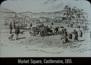 Bendigo Historical Society Inc.
Slide - DIGGERS & MINING. GOLD, c1855
Diggers & Mining. Gold. Market Square Castlemaine, Forest Creek. James J Bundell & Co, Melbourne 1855. Shows the small township, people wagons, dogs. Market Square Castlemaine, 1855. Markings: 26 994.GOL. Used as a teaching aid.hanimounteducation, tertiary, goldfields -
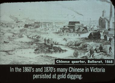 Bendigo Historical Society Inc.
Slide - DIGGERS & MINING. THE CHINESE ON THE GOLD FIELDS, c1868
Diggers & Mining. The Chinese on the Gold Fields. Slide: Chinese quarter, Ballarat, 1868. In the 1860s and 1870s many Chinese in Victoria persisted at gold digging. Slide shows township and Chinese along the creek looking for gold. Markings: 13. Used as a teaching aid.hanimounteducation, tertiary, goldfields -
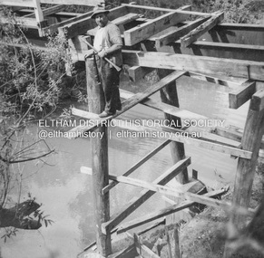 Eltham District Historical Society Inc
Album - Photograph, J.A. McDonald, General; Albion Street and Eltham-Yarra Glen Road, Oct. 1955
Eltham-Yarra Glen Road Lower Plenty Footbridge October 1955 (Jolly)Record of various Shire of Eltham infrastructure works undertaken during the period of 1952-1962 involving bridge and road reconstruction projects, sometimes with Eltham Shire Council Project Reference numbers quoted. It was during this period that a number of significant improvements were made to roads and new bridges constructed within the shire that remain in place as of present day (2022). In many situations, the photos provide a tangible visible record of infrastructure that existed throughout the early days of the Shire. The album was put together by or under the direction of the Shire Engineer, J.A. McDonald.infrastructure, road construction, shire of eltham, 1955-10, bridge construction, eltham-yarra glen road, lower plenty footbridge -
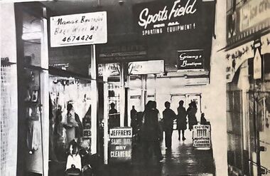 Greensborough Historical Society
Photograph - Newspaper Clipping - Digital Image, The Valley Voice, Bundoora Square 1978, 03/08/1978
Bundoora Square is the shopping centre on the corner of Plenty Road and Settlement Road Bundoora. Digital copy of newspaper photographbundoora square, bundoora shopping centre, plenty road bundoora -
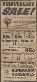 Greensborough Historical Society
Advertisement - Digital image, Diamond Valley News, Bundoora Nurseries, 1974, 24/09/1974
Advertisement for Bundoora Nurseries, corner Plenty Road and McLeans Road Bundoora, 1974.Digital copy of newspaper advertisement.bundoora nurseries, plenty road bundoora, mcleans road bundoora -
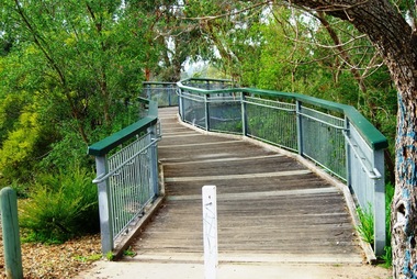 Greensborough Historical Society
Photograph - Digital image, Marilyn Smith, Partington's Flat: footbridge over the River, 16/08/2015
Partington's Flat. This photo shows the footbridge over the river on the Plenty River Trail.Digital copy of colour photographspartingtons flat, plenty river trail, plenty river -
 Greensborough Historical Society
Photograph - Digital image, Marilyn Smith, Partington's Flat: River crossing / floodway, 16/08/2015
Partington's Flat. This photo shows the floodway / river crossing over the Plenty River.Digital copy of colour photographpartingtons flat, plenty river -
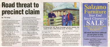 Whittlesea Historical Society Inc.
Newspaper - Newspaper Clipping, Whittlesea Leader, Road threat to precinct claim, 10 Aug 2004
An article about the Mayfield Precinct in Mernda becoming endangered if Plenty Road is widened.Newsprint with colour photomernda, richard ely, jean ely, the poplars mernda, bluestone house, mayfield precinct, wendy goodridge, bill goodridge -
 Greensborough Historical Society
Report, Examining Draughtsman's Report - Watts River Aqueduct, 20/07/1897
This Field Survey was commissioned by the Melbourne Board of Works and was used to position the Maroondah Aqueduct bridge north of Greensborough at its crossing point on the Plenty River. It incorporated the use of wrought iron water pipes and therefore is of lighter construction than other similar bridges in the district. It features a traverse of the Plenty RiverThe Maroondah Aqueduct bridge is a significant example of late 19th century engineering. A 4 page reproduction of an Office of Titles document. Copy of handwritten report includes maps.maroondah aqueduct, watts river aqueduct, bridge, greensborough, office of titles, 1897, wrought iron water pipes, plenty river, melbourne board of works -
Whitehorse Historical Society Inc.
Pamphlet, Beautiful Blackburn, The Travellers' rest Hotel|Hotels|Real Estate Agents|Caterers|Blackburn Recreation Hall
Booklet produced early 1900s extolling the virtues of 'Beautiful Blackburn - the Playground of Melbourne'.Booklet produced early 1900s extolling the virtues of 'Beautiful Blackburn - the Playground of Melbourne'. Includes photographs and advertisements from local businesses.Booklet produced early 1900s extolling the virtues of 'Beautiful Blackburn - the Playground of Melbourne'. blackburn lake, blackburn, blackburn railway station -
 Kiewa Valley Historical Society
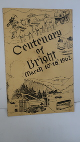
Booklet - Bright, Centenary of Bright March 10th - 18th, 1962
Township of Bright celebrated its centenary during the week from 10th - 18th March, 1962. This booklet outlines the program for the week.Bright is a nearby town to the the Kiewa Valley and currently the location of the current Shire (Alpine). The program gives historical information on activities in the early 1960s.Yellowy/Orange cover with brown title and sketch. One sketch is at the bottom and includes hills, pines, saw mill and bus. Sketch at the top is of a bullock team and in the middle on the right a gold miner. Inside cover has print as has both sides of the 4 pages held by 2 staples. 'C. Roper' on inside of the front cover.bright, centenary of bright -
 Greensborough Historical Society
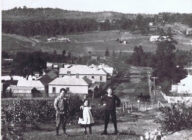
Photograph, Diamond Creek
This undated view of Diamond Creek shows three children on a hill looking over a small township with open fields and trees in background. Large black and white photograph of a view over a town and rural landscape.diamond creek -
 Halls Gap & Grampians Historical Society
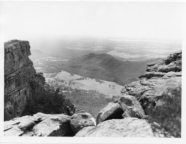
Photograph, C 1960s
The valley is known as Fyans Valley and the township of Halls Gap. Photo is typical of those taken by the Forestry Commission (Vic) during the 1960s.Photo shows two rocky outcrops in the foreground framing a valley in the distance below. A partial view of a mountain range flanks the valley. Plains of trees and open fields, and also a lake, can be seen beyond the mountain range. Within the valley in the middle of the photo buildings, roads and cleared land can be seen.scenery, fyans valley -
 Marysville & District Historical Society
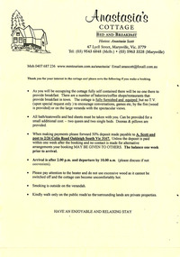
Ephemera (Item) - Reservation form, Anastasia's COTTAGE, Unknown
An information and reservation form for Anastasia's Cottage in Marysville. This cottage, along with most of the buildings in the township, was destroyed in the 2009 Black Saturday bushfires.An information and reservation form for Anastasia's Cottage in Marysville.marysville, victoria, australia, reservation form, accommodation, anastasia's cottage, 2009 black saturday bushfires -
 Clunes Museum
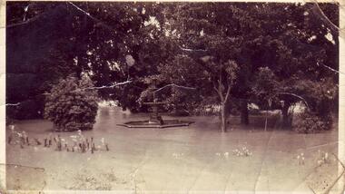
Photograph - PHOTOGRAPH FLOODS 1934
AFTER HEAVY RAINS - CRESWICK CREEK IN CLUNES TOWNSHIP FLOODED, OVER FLOWING ITS BANKS, NEAR BY AREAS WERE SUBMERGED.BLACK AND WHITE SMALL PHOTOGRAPH OF CLUNES FLOODS IN 1934. CLUNES QUEEN'S PARK WITH FOUNTAIN UNDER WATER - TREES IN THE BACKGROUND AND A FEW FLOWERS IN THE FOREGROUND.local history, queen's park garden., floods 1934 -
Port Melbourne Historical & Preservation Society
Film - CD-ROM, PMHPS Meeting, Presentation, Gems found at the Public Records Office Victoria, Steve Tserkezidis, 26 Jan 2015
PMHPS meeting 26.01.2015 Powerpoint presentation by Steve Tserkezidis on "gems found at the Public Records Office Victoria". Principally containing images and plans involving State Bank housing estates at Garden City, Fishermen's bend and the Dunstan estate. Images of the State Savings Bank building and Riall print have been separately extracted and entered on the database as cat nos 3468 to 3471 built environment - domestic, built environment - commercial, steve tserkezidis, state savings bank of victoria -
 Eltham District Historical Society Inc
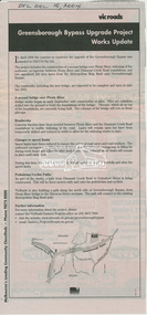
News Clipping, Advertisiing; Greensborough Bypass Upgrade Project Works Update, VicRoads, Diamond Valley Leader, 15 December 2004, 2004
Addition of second stage bridge over Plenty River and extension of ring road connectionNewsprintgreensborough bypass, road construction, vicroads -
 Greensborough Historical Society
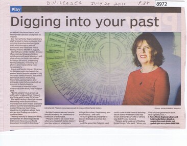
Article - Newspaper Clipping, Digging into your past, 28/07/2010
Article with Liz Pidgeon about researching Family History at Yarra Plenty Regional Library.Newspaper Clipping, text and colour imagefamily history, yarra plenty regional library, liz pidgeon -
 Greensborough Historical Society
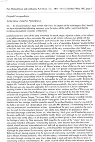
Article - Newspaper Clipping (copy), John Harrison, Original correspondence to the Editor, by John Harrison, 09/05/1842
Correction of a report made about the killing and capture of bushrangers raiding station on the Plenty River2 p. typescript copied from Port Phillip Patriot and Melbourne Advertiser 9 May 1842bushrangers, plenty river