Showing 10934 items
matching land
-
 City of Moorabbin Historical Society (Operating the Box Cottage Museum)
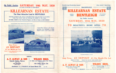
Flyer - Killearnan Estate, Bentleigh, 1930
The train line from the city to Frankston was electrified which intensified the sale in the municipality of Moorabbin, particularly land which was in the vicinity of the railway stations.Example of the progress of the Municipality of MoorabbinAdvertising flyer for auction of real estate sales - plan of building blocks for saleKillearnan Estate - 70 Homes Sites - Auction Saturday 10 May 1930thomas street, yawla street, huntley road, whitmuir road, bentleigh, whitmuir, killearnan, robert gray ford, mrs betsy armstrong, arthur crozier, real estate, auction, a. f. always & son, wilson bros., moorabbin, bentleigh club -
 City of Moorabbin Historical Society (Operating the Box Cottage Museum)
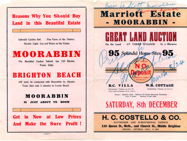
Flyer - Marriott Estate, Moorabbin, 1923
The train line from the city to Frankston was electrified which intensified the sale in the municipality of Moorabbin, particularly land which was in the vicinity of the railway stations.Example of the progress of the Municipality of MoorabbinAdvertising flyer for auction of real estate sales - plan of building blocks for saleMarriott Estate, Moorabbin Auction Saturday 8 December - 95 Splendid home sites - H. C. Costello & Comarriott, bentleigh, moorabbin, jasper road, mortimore street, fromer street, mckittrick street, real estate, auction -
 City of Moorabbin Historical Society (Operating the Box Cottage Museum)
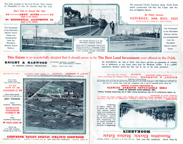
Flyer - Moorabbin Electric Station Estate, Moorabbin, 1925
The train line from the city to Frankston was electrified which intensified the sale in the municipality of Moorabbin, particularly land which was in the vicinity of the railway stations.Example of the progress of the Municipality of MoorabbinAdvertising flyer for auction of real estate sales - plan of building blocks for saleMoorabbin Electric Station Estate, Moorabbin - Auction Saturday 30 May 1925 - 65 Residential allotments Auctioneer Knight & Harwoodmoorabbin station, south road, station street, jasper street (now redholme street), central avenue, moorabbin, real estate, auction -
 City of Moorabbin Historical Society (Operating the Box Cottage Museum)
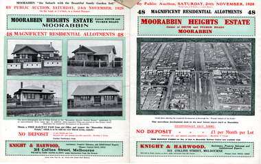
Flyer - Moorabbin Heights Estate, Moorabbin, 1928
The train line from the city to Frankston was electrified which intensified the sale in the municipality of Moorabbin, particularly land which was in the vicinity of the railway stations.Example of the progress of the Municipality of MoorabbinAdvertising flyer for auction of real estate sales - plan of building blocks for saleMoorabbin Heights Estate, Moorabbin - 48 residential allotments - Auction Saturday 24 November 1928moorabbin, bentleigh, east bentleigh, south road, tucker road, hinkler avenue, real estate, auction -
 City of Moorabbin Historical Society (Operating the Box Cottage Museum)
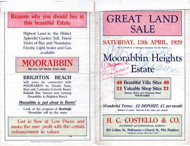
Flyer - Moorabbin Heights Estate, Moorabbin, 1929
The train line from the city to Frankston was electrified which intensified the sale in the municipality of Moorabbin, particularly land which was in the vicinity of the railway stations.Example of the progress of the Municipality of MoorabbinAdvertising flyer for auction of real estate sales - plan of building blocks for saleMoorabbin Heights Estate, Moorabbin 48 Villa sties, 21 Shop sites Sale on Saturday 13 April 1929 - H. C. Costello & CO.point nepean road (nepean highway), harding street, howell street, north avenue, coates street -
 City of Moorabbin Historical Society (Operating the Box Cottage Museum)
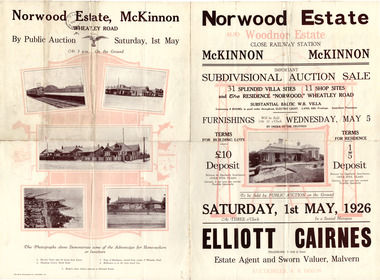
Flyer - Norwood Estate, McKinnon and Woodnor Estate, McKinnon, 1926
The train line from the city to Frankston was electrified which intensified the sale in the municipality of Moorabbin, particularly land which was in the vicinity of the railway stations.Example of the progress of the Municipality of MoorabbinAdvertising flyer for auction of real estate sales - plan of building blocks for saleNorwood and Woodnor Estate, McKinnon 31 Villa Site & 11 Shop sites - Auction Saturday 1 May - Auctioner Elliott Cairnesmckinnon, norwood, wheatley road, jean street, anne street, lysbeth street, mckinnon road, jasper road, real estate, auction -
 City of Moorabbin Historical Society (Operating the Box Cottage Museum)
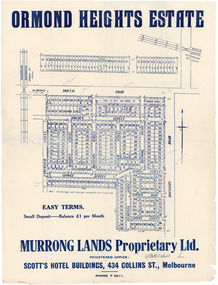
Flyer - Ormond Heights, East Bentleigh
The train line from the city to Frankston was electrified which intensified the sale in the municipality of Moorabbin, particularly land which was in the vicinity of the railway stations.Example of the progress of the Municipality of MoorabbinAdvertising flyer for auction of real estate sales - plan of building blocks for salenorth road, moulden street, george street, garden road, bruce street (now bethwyn street), boundary road (now east boundary road), murrong avenue, bay view street, rochford street, mitchell street, lancaster street, east bentleigh, real estate -
 City of Moorabbin Historical Society (Operating the Box Cottage Museum)
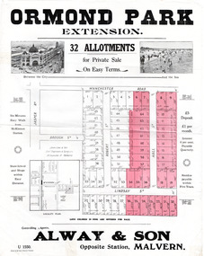
Flyer - Ormond Park Extension, Ormond, 1924
The train line from the city to Frankston was electrified which intensified the sale in the municipality of Moorabbin, particularly land which was in the vicinity of the railway stations.Example of the progress of the Municipality of MoorabbinAdvertising flyer for auction of real estate sales - plan of building blocks for saleOrmond Park Extension - 32 Allotment for Private Sale - Alway & Sonmanchester road (now mckinnon road), lindsay street, hall street, ormond, real estate -
 City of Moorabbin Historical Society (Operating the Box Cottage Museum)
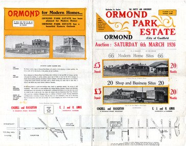
Flyer - Ormond Park Estate, Ormond, 1926
The train line from the city to Frankston was electrified which intensified the sale in the municipality of Moorabbin, particularly land which was in the vicinity of the railway stations.Example of the progress of the Municipality of MoorabbinAdvertising flyer for auction of real estate sales - plan of building blocks for saleOrmond Park Estate - 66 Home Sites and 20 shop and business sites - Coghill and Haughtonormond, real estate, koornang road, wallen grove, florence street, auction -
 Port Melbourne Historical & Preservation Society
Photograph - Station Street window, Excelsior Hall, Port Melbourne, David Thompson, Jun 1998
On ending of RSL lease and therefore imminent sale and development of the land - Princes to Station at Bridge - David THOMPSON recorded exterior details of the building.Photo: Station Street window, angled, from series of photos of Excelsior Hall ('Diggers' Hall'), RSL Port Melbourne branch headquarters 1948 - 1998. Made June 1998 by David THOMPSON.societies clubs unions and other organisations, excelsior hall, built environment, returned services league, rsl -
Port Melbourne Historical & Preservation Society
Photograph - RSL' detail inlaid in terrazzo, front gate, Excelsior Hall, Port Melbourne, David Thompson, Jun 1998
On ending of RSL lease and therefore imminent sale and development of the land - Princes to Station at Bridge - David THOMPSON recorded exterior details of the building.Photo: detail of 'RSL' inlaid in terrazzo, Princes Street entrance. From series of photos of Excelsior Hall ('Diggers' Hall'), RSL Port Melbourne branch headquarters 1948 - 1998. Made June 1998 by David THOMPSON.societies clubs unions and other organisations, excelsior hall, built environment, returned services league, rsl -
Port Melbourne Historical & Preservation Society
Photograph - RSL Shield, Excelsior Hall, Port Melbourne, David Thompson, Jun 1998
On ending of RSL lease and therefore imminent sale and development of the land - Princes to Station at Bridge - David Thompson recorded exterior details of the building.Photo: detail of RSL shield, from series of photos of Excelsior Hall ('Diggers' Hall'), RSL Port Melbourne branch headquarters 1948 - 1998. Made June 1998 by David THOMPSON.societies clubs unions and other organisations, excelsior hall, built environment, returned services league, rsl -
Port Melbourne Historical & Preservation Society
Photograph - Princes Street entrance, Excelsior Hall, Port Melbourne, David Thompson, Jun 1998
On ending of RSL lease and therefore imminent sale and development of the land - Princes to Station at Bridge - David THOMPSON recorded exterior details of the building.Photo: detail of Princes St entrance, from series of photos of Excelsior Hall ('Diggers' Hall'), RSL Port Melbourne branch headquarters 1948 - 1998. Made June 1998 by David THOMPSON.societies clubs unions and other organisations, excelsior hall, built environment, returned services league, rsl -
Port Melbourne Historical & Preservation Society
Photograph - Excelsior Hall from Princes Street, Port Melbourne, David Thompson, Jun 1998
On ending of RSL lease and therefore imminent sale and development of the land - Princes to Station at Bridge - David THOMPSON recorded exterior details of the building.Photo: building, Princes Street, from series of photos of Excelsior Hall ('Diggers' Hall'), RSL Port Melbourne branch headquarters 1948 - 1998. Made June 1998 by David THOMPSON.societies clubs unions and other organisations, excelsior hall, built environment, returned services league, rsl -
Port Melbourne Historical & Preservation Society
Photograph - Letter 'R' from RSL on gate on Bridge Street side of Excelsior Hall, Port Melbourne, David Thompson, Jun 1998
On ending of RSL lease and therefore imminent sale and development of the land - Princes to Station at Bridge - David THOMPSON recorded exterior details of the building.Photo: detail of 'R' from gate at Bridge Street side, from series of photos of Excelsior Hall ('Diggers' Hall'), RSL Port Melbourne branch headquarters 1948 - 1998. Made June 1998 by David THOMPSON.societies clubs unions and other organisations, excelsior hall, built environment, returned services league, rsl -
Port Melbourne Historical & Preservation Society
Photograph - Letter 'S' from RSL on gate on Bridge Street side of Excelsior Hall, Port Melbourne, David Thompson, Jun 1998
On ending of RSL lease and therefore imminent sale and development of the land - Princes to Station at Bridge - David THOMPSON recorded exterior details of the building.Photo: detail of 'S' from gate at Bridge Street side, from series of photos of Excelsior Hall ('Diggers' Hall'), RSL Port Melbourne branch headquarters 1948 - 1998. Made June 1998 by David THOMPSON.societies clubs unions and other organisations, excelsior hall, built environment, returned services league, rsl -
Port Melbourne Historical & Preservation Society
Photograph - Letter 'L' from RSL on gate on Bridge Street side of Excelsior Hall, Port Melbourne, David Thompson, Jun 1998
On ending of RSL lease and therefore imminent sale and development of the land - Princes to Station at Bridge - David THOMPSON recorded exterior details of the building.Photo: detail of 'L' from gate at Bridge Street side, from series of photos of Excelsior Hall ('Diggers' Hall'), RSL Port Melbourne branch headquarters 1948 - 1998. Made June 1998 by David THOMPSON.societies clubs unions and other organisations, excelsior hall, built environment, returned services league, rsl -
Port Melbourne Historical & Preservation Society
Photograph - Bridge Street side of Excelsior Hall, Port Melbourne, David Thompson, Jun 1998
On ending of RSL lease and therefore imminent sale and development of the land - Princes to Station at Bridge - David THOMPSON recorded exterior details of the building.Photo: Bridge Street side of hall, from series of photos of Excelsior Hall ('Diggers' Hall'), RSL Port Melbourne branch headquarters 1948 - 1998. Made June 1998 by David THOMPSON.societies clubs unions and other organisations, excelsior hall, built environment, returned services league, rsl -
Port Melbourne Historical & Preservation Society
Photograph - Station Street entrance, Excelsior Hall, Port Melbourne, David Thompson, Jun 1998
On ending of RSL lease and therefore imminent sale and development of the land - Princes to Station at Bridge - David THOMPSON recorded exterior details of the building.Photo: entrance in Station Street, from series of photos of Excelsior Hall ('Diggers' Hall'), RSL Port Melbourne branch headquarters 1948 - 1998. Made June 1998 by David THOMPSON.societies clubs unions and other organisations, excelsior hall, built environment, returned services league, rsl -
Port Melbourne Historical & Preservation Society
Photograph - Excelsior Hall from Railway Reserve, Station Street, Port Melbourne, David Thompson, Jun 1998
On ending of RSL lease and therefore imminent sale and development of the land - Princes to Station at Bridge - David THOMPSON recorded exterior details of the building.Photo: view from railway reserve of Station Street facade, from series of photos of Excelsior Hall ('Diggers' Hall'), RSL Port Melbourne branch headquarters 1948 - 1998. Made June 1998 by David THOMPSON.societies clubs unions and other organisations, excelsior hall, built environment, returned services league, rsl -
Port Melbourne Historical & Preservation Society
Photograph - Station Street louvred window, Excelsior Hall, Port Melbourne, David Thompson, Jun 1998
On ending of RSL lease and therefore imminent sale and development of the land - Princes to Station at Bridge - David THOMPSON recorded exterior details of the building.Photo: louvred window, Station Street, from series of photos of Excelsior Hall ('Diggers' Hall'), RSL Port Melbourne branch headquarters 1948 - 1998. Made June 1998 by David THOMPSON.societies clubs unions and other organisations, excelsior hall, built environment, returned services league, rsl -
Port Melbourne Historical & Preservation Society
Photograph - Station Street side window, Excelsior Hall, Port Melbourne, David Thompson, Jun 1998
On ending of RSL lease and therefore imminent sale and development of the land - Princes to Station at Bridge - David THOMPSON recorded exterior details of the building.Photo: side window, Station Street, from series of photos of Excelsior Hall ('Diggers' Hall'), RSL Port Melbourne branch headquarters 1948 - 1998. Made June 1998 by David THOMPSON.societies clubs unions and other organisations, excelsior hall, built environment, returned services league, rsl -
Port Melbourne Historical & Preservation Society
Photograph - Princes Street façade, Excelsior Hall, Port Melbourne, David Thompson, Jun 1998
On ending of RSL lease and therefore imminent sale and development of the land - Princes to Station at Bridge - David THOMPSON recorded exterior details of the building.Photo: Princes Street facade, upper detail. From series of photos of Excelsior Hall ('Diggers' Hall'), RSL Port Melbourne branch headquarters 1948 - 1998. Made June 1998 by David THOMPSON.societies clubs unions and other organisations, excelsior hall, built environment, returned services league, rsl -
Port Melbourne Historical & Preservation Society
Photograph - Princes Street façade, Excelsior Hall, Port Melbourne, David Thompson, Jun 1998
On ending of RSL lease and therefore imminent sale and development of the land - Princes to Station at Bridge - David THOMPSON recorded exterior details of the building.Photo: close up of Princes Street facade, upper detail. From series of photos of Excelsior Hall ('Diggers' Hall'), RSL Port Melbourne branch headquarters 1948 - 1998. Made June 1998 by David THOMPSON.societies clubs unions and other organisations, excelsior hall, built environment, returned services league, rsl -
Port Melbourne Historical & Preservation Society
Photograph - Excelsior Hall from corner Princes and Bridge Streets, Port Melbourne, David Thompson, Jun 1998
On ending of RSL lease and therefore imminent sale and development of the land - Princes to Station at Bridge - David THOMPSON recorded exterior details of the building.Photo: view from Princes and Bridge Streets. From series of photos of Excelsior Hall ('Diggers' Hall'), RSL Port Melbourne branch headquarters 1948 - 1998. Made June 1998 by David THOMPSON.societies clubs unions and other organisations, excelsior hall, built environment, returned services league, rsl -
Port Melbourne Historical & Preservation Society
Photograph - Excelsior Hall from corner Princes and Bridge Streets, Port Melbourne, David Thompson, Jun 1998
On ending of RSL lease and therefore imminent sale and development of the land - Princes to Station at Bridge - David THOMPSON recorded exterior details of the building.Photo: view from Princes and Bridge Streets, showing Dispensary. From series of photos of Excelsior Hall ('Diggers' Hall'), RSL Port Melbourne branch headquarters 1948 - 1998. Made June 1998 by David THOMPSON.societies clubs unions and other organisations, excelsior hall, built environment, returned services league, rsl -
Port Melbourne Historical & Preservation Society
Photograph - RSL' detail on Princes Street entrance, Excelsior Hall, Port Melbourne, David Thompson, Jun 1998
On ending of RSL lease and therefore imminent sale and development of the land - Princes to Station at Bridge - David THOMPSON recorded exterior details of the building.Photo: detail of wrought iron 'RSL' on Princes Street entrance (background brick). From series of photos of Excelsior Hall ('Diggers' Hall'), RSL Port Melbourne branch headquarters 1948 - 1998. Made June 1998 by David THOMPSON.societies clubs unions and other organisations, excelsior hall, built environment, returned services league, rsl -
Port Melbourne Historical & Preservation Society
Photograph - RSL' detail on Princes Street entrance, Excelsior Hall, Port Melbourne, David Thompson, Jun 1998
On ending of RSL lease and therefore imminent sale and development of the land - Princes to Station at Bridge - David THOMPSON recorded exterior details of the building.Photo: detail of wrought iron 'RSL' on Princes Street entrance (background door). From series of photos of Excelsior Hall ('Diggers' Hall'), RSL Port Melbourne branch headquarters 1948 - 1998. Made June 1998 by David THOMPSON.societies clubs unions and other organisations, excelsior hall, built environment, returned services league, rsl -
Port Melbourne Historical & Preservation Society
Photograph - RSL' detail inlaid in terrazzo, front gate, Excelsior Hall, Port Melbourne, David Thompson, Jun 1998
On ending of RSL lease and therefore imminent sale and development of the land - Princes to Station at Bridge - David THOMPSON recorded exterior details of the building.Photo: detail of 'RSL' inlaid in terrazzo, front gate. From series of photos of Excelsior Hall ('Diggers' Hall'), RSL Port Melbourne branch headquarters 1948 - 1998. Made June 1998 by David THOMPSON.societies clubs unions and other organisations, excelsior hall, built environment, returned services league, rsl -
Port Melbourne Historical & Preservation Society
Photograph - Side of Excelsior Hall from Bridge Street, Port Melbourne, David Thompson, Jun 1998
On ending of RSL lease and therefore imminent sale and development of the land - Princes to Station at Bridge - David THOMPSON recorded exterior details of the building.Photo: side of hall from Bridge Street. From series of photos of Excelsior Hall ('Diggers' Hall'), RSL Port Melbourne branch headquarters 1948 - 1998. Made June 1998 by David THOMPSON.societies clubs unions and other organisations, excelsior hall, built environment, returned services league, rsl