Showing 10463 items
matching sites
-
 The Beechworth Burke Museum
Photograph - Photograph - Reproduction, c1920
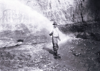
This photograph depicts mining operations (in particular, hydrolic sluicing) at Three Mile Mine, Barramutha, during the later periods of mining, 1920s-1950s. Three Mile Mine was a major site of mining activity sating back to the 1850s, although was often not as prosperous as other sites such as those situated on the Woolshed Valley. Many miners would leave Three Mile Mine for better prospects on other claims. The main, most successful 'rush' at Three Mile Mine occurred during and immediately following September 1855. This photograph, however, depicts a much later period.The search for gold is ingrained into the history of Victoria and therefore, images like this one which portray a miner at a sluicing site can reveal important information for society and technology for the date when the photograph was taken. This image, and its related images, it important for its historical significant of labour and mining extraction used for gold during the latter gold rushes in the 1900s. The Beechworth Burke Museum has additional images relating to gold mining in the region which can be analysed and studied alongside images like this one.A black and white rectangular photograph printed on matte photographic paperreverse: 7597.4 / copied from original on loan from Webb (Qld) / Donated Nov 2009 / Baarmutha Three Mile Mine 1920-1950 / Owned by Plain Bros then Parkinsons / John Weir or Jack Cox / Sluicing /mining, barramutha, three mile mine, sluicing, mine, beechworth -
 Warrnambool and District Historical Society Inc.
Functional object - Printing block: Warrnambool Historical Society logo, 1980s
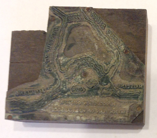
This printers block was made for the Warrnambool and District Historical Society and used to print letterheads, envelopes and cards. The impression on the block is of the sketch map drawn by Thomas Price of Port Fairy of the Warrnambool Harbour site when he wrote to Superintendent Charles LaTrobe in 1844 regarding the suitability of the site for a new town. The letter is regarded as an important impetus for La Trobe to consider establishing the town of Warrnambool and so the sketch was used by the Historical Society as its logo on letterheads etc for many years. It was also used as the heading for the Society newsletters from the late 1980s to late 2007.This block of the Thomas Price sketch was used by the Historical Society for many years for its printed material and the sketch was used as its logo for about 20 years so it is an important part of the Society’s history and the block is kept as a reminder of this.This is a printing block with an impression made of metal and attached to a wooden block. The wood is in layers of dark and light coloured wood and has a piece cut out at the top left hand corner. The impression is a representation of the sketch map of Warrnambool Harbour made by Thomas Price in 1844.Sketch map of Warrnambool Harbour 1844warrnambool & district historical society, thomas price sketch -
 Eltham District Historical Society Inc
Document - Series Listing, Fraser Faithfull et al, Series 13: Eltham Shire Photograph Album 1985, 2000
Series consists of 174 colour and B&W photographs of sites and activities in the Shire of Eltham. Most shots are 150mm by 100, though there are a number of smaller shots laid out in montages, and 6 large (A4 size) colour shots. Subjects documented include the Eltham Library, Eltham Lower Park, Eltham Senior Citizens Centre, Housing Development, the Council Depot, Shire Offices, Eltham Child Care Centre, Miniature Railway, Community Centre, the Bike Track, a Citizenship Ceremony, Shillingham Cottage, Eltham Town Park and other sites.shire of eltham archives, series listing -
 Bendigo Historical Society Inc.
Souvenir - Photographs: Central Deborah Mine
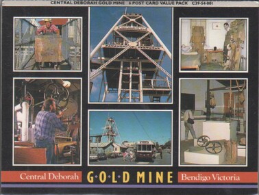
The Central Deborah Mine closed it's mining operations in 1954. The complete nature of the site encouraged the Bendigo City Council to purchase the site in 1970 in order that it be preserved. In 1971 the Bendigo Trust was formed and under its auspices the surface was opened to tourists in 1971' Extensive work enabled Level 2, underground to be opened to the public. This was followed in 1998 by Underground Level 3 Adventure tours. In 2011 visitors were able to tour as far down as Level 9, 228 meters below ground making it the deepest underground mine tour.Concertina souvenir six photographs of mining at Central Deborah Gold Mine Bendigo Victoria. Could be broken up to send as six separate postcardspostcards, central deborah mine -
 Falls Creek Historical Society
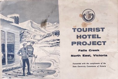
Document - Tourist Hotel Project, 1963
State Electricity Commission (SEC) outlined details of a site available for the development of a Tourist Hotel Project in Falls Creek in late 1962/3. SEC estimated that by the winter of 1963 Falls Creek Village would be able to accommodate 500 persons. The site for development was up to 2½ acres adjacent to the Upper Kiewa Valley Road. It envisaged a building able to accommodate about 100 guests. The successful developer would be granted a lease for 45 years at a rent of £300 per annum. Written applications for the lease were to be submitted by 31st March 1963.This item is significant because it documents plans made by the State Electricity Commission to develop the Falls Creek Tourist Area. A folder with a black and white image of skiers outside a hotel on the left. The logo of the State Electricity Commission and text is on the right half of the folder.On right half of cover: Logo of the State Electricity Commission TOURIST HOTEL PROJECT Falls Creek / North East Victoria Forwarded with the compliments of the State Electricity Commission of Victoriafalls creek tourist area, hotel development falls creek, falls creek projects 1963 -
 Melbourne Legacy
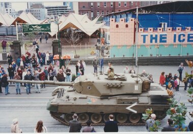
Photograph - Photo, Tanks on Swanston Street
Photos of two tanks driving along Swanston Street taken from the windows of Legacy House. The occasion is not known. The tanks appear to be Leopard 1. One has elaborate equipment on the front. The date is approximately the late 1990s as the Queen Victoria Hospital has been demolished and the QV building has not been started. On the site opposite Legacy House is an open air market called The Sailyards, and what appears to be an ice rink or mini golf, called The Icehouse. Also on the site was the YMCA run skate park called Sail Yards, it was closed in 2001.A record that military equipment was of interest to the Legatees.Colour photos x 4 of two tanks driving North up Swanston Streettanks, streetscape -
 Bendigo Historical Society Inc.
Document - VICTORIA HILL - THE BENDIGO DIGGINGS, PRELIMINARY DRAFT FOR BROCHURE
Nine typed pages of notes on a preliminary draft for a brochure on the Bendigo Diggings. First part is the objective which is to preserve the mining history and to have exhibits in the places they were used, e.g. quartz mining machinery exhibited in a quartz mining area, not on an alluvial field. Part B is historical notes on the area. Part C is the Site - Victoria Hill area. Part D is Stage One which consists of carpark area, technological museum, restaurant, mineral haulage line, picnic ground, earthworks and planting over the area. Part E is Stage Two which will consist of the open-air exhibits, in the area surrounded by the mineral haulage line, and the Central Nell Gwynne mine on the west side of the site. Part F is Stage Three which will consist of the winery, the steam tram track, the lake, the wildlife sanctuary and various buildings associated with gold mining. Part G is Costing with the prices to be filled in. Parts H and I are the Appeal and the Committee. Details to be filled in.mining, marketing, victoria hill, victoria hill, the bendigo diggings - preliminary draft for brochure, aust national travel association, tullamarine jetport, emu bottom homestead, kyneton historical museum, chinese joss house, eaglehawk museum, whipstick scrub, cairn curran reservoir, castelmaine historical museum and market hall, national trust, ballarat hiatorical park, echuca's hopwood gardens, swan hill folk museum, gibson's mount alexander no 2 squatting run, captain brown, chief commissioner wright, hustler's reef, thomas hustler, mining board, drainage of reefs act 1862, first world war, bendigo amalgamated goldfields, second world war, sandhurst, w c vahland, battery trams, horse trams, steam trams, electric trams, central nell gwynne mine, theodore ballerstadt, george lansell, new chum hill, ballerstadt's open cut, 180 mine, new chum syncline battery, william rae, victoria quartz, wittscheibe's 'jeweller's shop', luffsman and sterry, gold mines hotel, adventure, bendigo and district tourist association, bendigo city council, bendigo branch of the royal historical society of victoria, professor brian lewis, school of architecture and building at the university of melbourne, taylor horsfield, lord robert cecil, south australian gold commissioner -
 Bendigo Historical Society Inc.
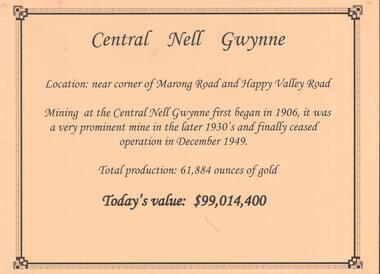
Document - CENTRAL NELL GWYNNE GOLD MINE
Interpretive sign and 4 photos Central Nell Gwynne Gold Mine, used in display. Central Nell Gwynne was located near the corner of Marong Road and Happy Valley Road. Opened in 1906, ceased operation in December 1949. Total production: 61,884 ounces of Gold. Today's Value: $99,014,400. Photos: a. Colour photo, concrete footings at mine site, April 2012. b. Colour photo, Central Nell Gwynne poppet head, April 2012.Poppet head painted white with red trim. Concrete footings in foreround. c. Central Nell Gwynne mine site 1930's. Poppet head and engine room sheds on LH side, trestle way to primary crusher and crushing battery. Tailing dam in immediate foreground. on RH side. Sand heaps in middle foreground. d. Central Nell Gwynne Mine 1930. Underground view, men holding carbide lamps working at 265 level in mine. Large quartz spur formation visible in foreground.bendigo, mining, central nell gwynne -
 Melbourne Tram Museum
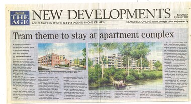
Newspaper, The Age, Progress Press, "Tram theme to stay at apartment complex", 2000
Set of 6 newspaper cuttings about the redevelopment of the site to apartments and the Hawthorn Tram Museum Depot. .1 - The Age - 8 Jan. 2000 - "Tram theme to stay at apartment complex" - announcing the redevelopment and plans for the redevelopment of Hawthorn tram depot. Includes architects impressions. Article by Victoria Gurvich. .2 -The Age - 14/1/2000 - letter to the Editor by Peter Moon - "Tram plan: too big and too ugly". .3 - Press - 21/2/2000 - "Trams on track for 498 years, Depot housing in line with history" - with photo of Mike Ryan and Matt Faubel (old photo) - article by Laeta Antonysen. .4 - ditto - "Outcry over historic site" and "Developers asked for another aspect" .5 - Progress Press - 6/3/2000 - letter re the redevelopment from John Santoro or Power St Hawthorn. .6 - Progress Press - 7/8/2000 - "Green light for tram depot apartments" - about the City of Boroondara issuing the planning permit.trams, tramways, hawthorn tram depot, tram museum, museums, minister for transport, city of boroondara -
 Ringwood and District Historical Society
Pamphlet, Subdivisional Auction Sale, Bedford Park, Ringwood - 1924
Bedford Park subdivisional development did not eventuate. The land adjoining the railway line became parkland with provision for sporting facilities and the remainder was purchased by the Education Department as the site for Ringwood High School/Secondary College. Double sided bifolded auction sale advertisement including subdivision features and local facilitiesSubdivision plan includes Bedford Road, Graham Road, Joyce Street, Anderson Street, and Adams Street -
 Warrnambool and District Historical Society Inc.
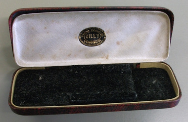
Domestic object - Case, spectacles, spectacles Case, 1900-1960
Frederick James Gill operated from the early part of the 20th century, through until around the 1960’s. He died in Warrnambool in 1961. There is still a jeweller operating from the same site today.A common item with a link to a Warrnambool businessDark red and black patterned hard case with rounded corners. Lined with cream satin with black felt insert. Metal hinges.Oval sticker: Gill’s jewellers, watchmakers Warrnambool.warrnambool, f.j. gill, jeweller, frederick james gill -
 Warrnambool and District Historical Society Inc.
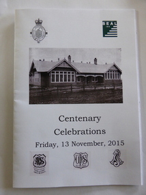
Invitation, Centenary of the School on the Hill, 2015
An Invitation to the Centenary of the School on the Hill which housed at various times, the Warrnambool Agricultural High School, Warrnambool High School, Warrnambool Technical School SEAL Inc and with the Warrnambool Special School on the same site.Many students from Warrnambool and the surrounding district would have been students at one of the various schools which have occupied this site from time to time from the earliest in 1915 to the present time and as such has historic and social significance to the town.White paper with black print A4sizewarrnambool agricultural high school, warrnambool high school, warrnambool technical school, schools of warrnambool, warrnambool special school -
Glen Eira Historical Society
Letter - Vadlure
Photocopy of a letter dated January 09, 1891 to J.A. Wallace from W.A. Zeal giving valuation of property Vadlure with a description of the house, outbuildings and gardens. Includes two copies of same site plan.vadlure, mansions, peterson john s, dandenong road, caulfield north, queen anne style, towers, art buildings, vegetable gardens, kooyong road, alma road, seal w.a., land values, engineers, surveyors -
 Eltham District Historical Society Inc
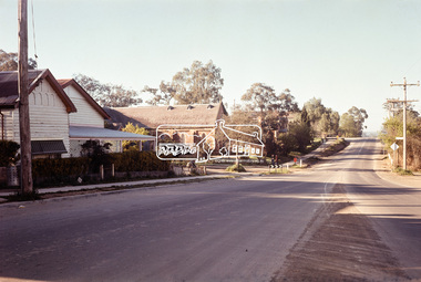
Photograph, Looking south along Main Road, Eltham near John Street, c.1970, 1970c
Eltham Uniting Church and former CBA bank (later Opportunity Shop) in centre left. The building on immediate left has since been demolished and is now the site of Goodstart Early Learning Eltham kinder120 format 6x9 clr positivecba bank, john street, main road, pitt street, uniting church -
 Greensborough Historical Society
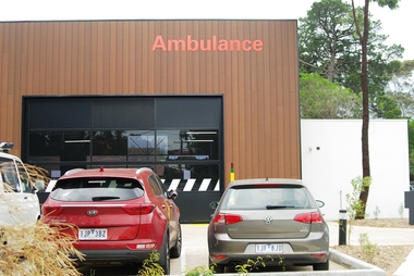
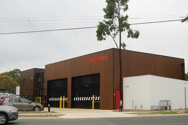
Photograph - Digital Image, Marilyn Smith, Eltham Ambulance Branch from Apex Way, 2018, 03/12/2018
Eltham Ambulance Branch, Apex Way Montmorency. The original ambulance station on this site was opened in 1975 and demolished in 2017. This photograph shows the new ambulance station, opened in 2018, from the front in Apex Way.Digital copy of colour photographeltham ambulance station, ambulance victoria, apex way montmorency -
 Greensborough Historical Society
Photograph - Digital Image, Marilyn Smith, Eltham Ambulance Branch from Grand Boulevard, 2018, 03/12/2018
Eltham Ambulance Branch, Apex Way Montmorency. The original ambulance station on this site was opened in 1975 and demolished in 2017. This photograph shows the new ambulance station, opened in 2018, from the front Grand Boulevard.Digital copy of colour photographeltham ambulance station, ambulance victoria, apex way montmorency, grand boulevard montmorency -
 Greensborough Historical Society
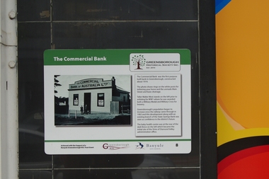
Photograph - Digital Image, Main Street Plaques: Commercial Bank, 18/06/2018
Historical Plaques in the Greensborough shopping strip. The Commercial Bank was the first purpose-built bank in Greensborough. It stood near the current (2019) site of LaPorchetta in Main Street. Further information available on GHS website.The Main Street Plaques Project was undertaken by Greensborough Historical Society and made possible with a grant from the Greensborough RSL.Digital copies of 2 colour photographsmain street greensborough, main street plaques project -
 Greensborough Historical Society
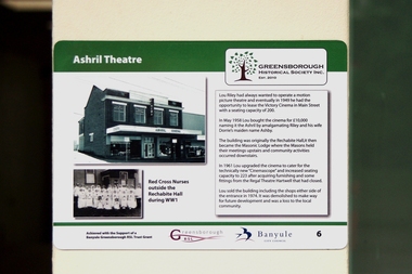
Photograph - Digital Image, Main Street Plaques: Ashril Theatre, 18/06/2018
Historical Plaques in the Greensborough shopping strip. The Ashril Theatre in Main Street Greensborough. This Theatre stood near the current (2019) site of the Plaza entrance in Main Street. Further information available on GHS website.The Main Street Plaques Project was undertaken by Greensborough Historical Society and made possible with a grant from the Greensborough RSL. Digital copy colour photographmain street greensborough, main street plaques project, ashril theatre -
 Greensborough Historical Society
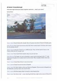
Article and Photograph, All Saints' Greensborough, 2018_
Information and photos of the original All Saints' Church of England in Greensborough; the land was later sold to Coles to build a new store and the Church was rebuilt on its current site on corner of Grimshaw and Church Streets Greensborough. This photograph and text was copied from a Facebook site. Members are people who lived in the Greensborough area and share their reminiscences of the area with others. The site is administered by a GHS member but is not officially affiliated with the Society. Any information is the opinion of the contributor. Article and photograph sourced from social media.all saints church of england, all saints anglican church greensborough -
 Greensborough Historical Society
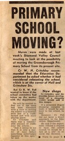
Newspaper Clipping - Digital Image, Primary School Moving? Greensborough Primary School Gr2062, 21/08/1973
Diamond Valley Councillors look at the possibility of moving Greensborough Primary School from its site on Grimshaw Street. [1973] The proposed new shopping complex for Greensborough would add to the dangers of traffic in the area. Digital copy of newspaper article, black text and image.greensborough primary school -
 Greensborough Historical Society
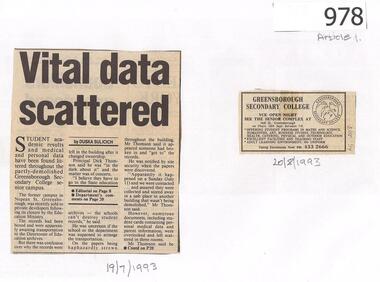
Newspaper Clippings, Diamond Valley News, Vital data scattered / Outrage at littered documents, 19/07/1993
Following the sale of Greensborough Secondary College's Nepean Campus site, student files, academic records and medical data were found scattered in the building. Article 2 interviews past students about the records.2 newspaper articles, text and images.greensborough secondary college, nepean campus -
 Greensborough Historical Society
Photograph - Digital image, Trevor Partington's Church Street property 1973, 1973_
Two photographs of a Church Street Greensborough property owned by Trevor Partington. This property was acquired during the construction of Greensborough Plaza and is now the site of the Church Street car park. (Copied 31/10/2011)The Partington family are Greensborough pioneers.Digital copy of 2 colour photographs.church street, trevor partington -
![Photograph - Digital image, Bluestone bridge [Greensborough], 02/05/2013](/media/collectors/4f729f5697f83e03086015b8/items/57286ede2162f115acc6c06f/item-media/57286f112162f115acc6c886/item-fit-380x285.jpg) Greensborough Historical Society
Greensborough Historical SocietyPhotograph - Digital image, Bluestone bridge [Greensborough], 02/05/2013
This photograph of the site of the Bluestone Bridge in Main Street Greensborough was taken in 2013 to show changes over 40 years, based on Ron Reynold’s sketches in the 1973 publication “Greensborough and Greenhills” published by Cypress Books.Digital copy of colour photograph.greensborough and greenhills, ron reynolds, main street greensborough, bluestone bridge greensborough -
 Greensborough Historical Society
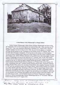
Article, A Brief history of the Whatmough's at Happy Hollow, 1960s
Information about Robert William Whatmough b. 1815 in Heywood, England and his son Robert Emmett Whatmough b. 1842 in Greensborough, d. 1924, who leased the site of Happy Hollow in 1892.1 p. typescript, 1 black and white photograph Notes on Whatmough family handwritten on bottom of page.whatmough family, happy hollow farm -
Glenelg Shire Council Cultural Collection
Headwear - Cap - Pacific Hydro, n.d
Pacific Hydro is the company which runs the Portland Wind Farm. It is one of Australia's larges wind farms and consists of four sites - Yambuk, Cape Bridgewater, Cape Nelson and Cape Sir William Grant.Navy fabric peaked cap (recycled polyester). Embroidered logo on front 'Pacific Hydro'. Buttonhole eyelets around crown, adjustable velcro fastening at back, fabric covered button top of cappacific hydro, renewable energy, wind farm, souvenir hat -
 Halls Gap & Grampians Historical Society
Photograph - B/W, 1920-1930
During the period 1924-1967 Bellfield operated as a licenced hotel. It became a popular destination for couples on their honeymoon The hotel was razed to the ground by fire in 1967 and was never rebuilt. The Grampians Motel now occupies the sitephotograph shows right hand section of Bellfield Hotel with woman on verandah to the right of bare tree Wonderland Range behindcopy done by AGFA Dec 99accommodation, hotels, bellfield -
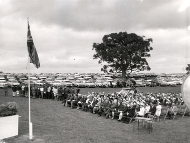 Federation University Historical Collection
Photograph - Photo, Noel L. Harvey & Son, Turning of the Sod at Mount Helen, 1967, 19/10/1967
The Mount Helen site was selected for the tertiary division of the Ballarat School of Mines, known as the Ballarat Institute of Advanced Education. The turning of the sod for the first buildings took place on 19 October 1967 By Lord Casey.A set of black and white photographs of the turning of the sod ceremony at Mount Helen. mount helen, ballarat institute of advanced education, ballarat school of mines, john, casey, trudinger, barker, turning the sod, mt helen campus opening, lord casey -
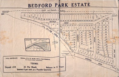 Ringwood and District Historical Society
Plan - Sub-division, Bedford Park Estate, Ringwood, Victoria - 1924
Bedford Park subdivisional development did not eventuate. The land adjoining the railway line became parkland with provision for sporting facilities and the remainder was purchased by the Education Department as the site for Ringwood High School/Secondary College. Poster size land sale advertisement.Subdivision plan includes Bedford Road, Graham Road, Joyce Street, Anderson Street, and Adams Street. Solicitors - W.R.R. Blair, Son & Falconbridge, 405 Collins Street, Melbourne. -
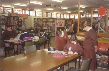 Galen Catholic College
Galen Catholic College Library Extension, 1993 - 1994
With the consolidation of Galen Catholic College onto the one campus in 1990, the 1990s were a period of intense development of buildings and other infrastructure on the Phillipson Street site. In 1993 and 1994, the existing library was greatly extended. galen catholic college, galen college, library, school grounds & buildings, galen library -
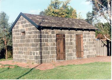 Hume City Civic Collection
Photograph
The Aitken Gap Gaol was originally constructed at the Gap Settlement on the Calder Highway in 1857 for the gold escorts. It was relocated to its present site outside the Sunbury Police Station in Macedon Street between 1989 and 1991.A coloured photograph of the relocated Aitken Gap Gaol. It has bluestone walls and a moss covered slate roof. with 2 solid stained wooden doors and blue painted wooden trims. A small cell window is on the side of the building and a paved brick area surrounds the gaol.aitken gap gaol, gap village, sunbury police station, george evans collection