Showing 175295 items
matching beach-street
-
 Phillip Island and District Historical Society Inc.
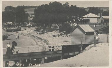
Photograph - Post Card, Late 1800's Early 1900's
Donated by Edith ElmsBlack & White Postcard of two ladies and child on Jetty with shed. Two boats moored on beach. People walking along street in background in front of houses. People walking along the beach."San Remo Sports"san remo beach, san remo, phillip island, edith elms -
 Eltham District Historical Society Inc
Photograph, George Coop, Flinders Street bound Comeng train near Banksia Street overpass, Heidelberg, 23 August 1983, 1983
Looking southwest towards Banksia Street overpassDigital TIFF file Scan of 35mm Kodak Safety 5062 black and white transparencybanksia street, comeng electric train (1981), heidelberg railway station, overpass -
 Surrey Hills Historical Society Collection
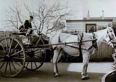
Photograph, Thomas William Hall of 10 Pembroke Street Surrey Hills, 1940
Date is approximate. Donor is the widow of Thomas Hall. Biographical notes provided: Thomas was born in Melbourne on 14/9/1928 and lived at Olinda until c1932 when his family moved to 10 Pembroke Street, Surrey Hills. He attended Surrey Hills State School, then went on to Box Hill High School (and / or Technical School - both are mentioned). He bought a horse and cart in order to be able to make deliveries for trades people and hence pay his way through technical school. He attended technical school 3 evenings per week studying building, carpentry, plumbing, electrical work and bricklaying. He built many homes in the eastern suburbs. He played tennis and attended church at Church of Christ. Married Margaret on 2/4/1955. Retired to Dromana where he was a member of the garden club at Redhill. Died 24/7/2004.Black and white photo of a boy identified as Thomas William Hall of 10 Pembroke Street, Surrey Hills sitting on a delivery cart with Snowy the horse in harness. "T Hall / ....." is painted on to the side of the cart. Taken in the backyard of his home in readiness for making deliveries."THOMAS WILLIAM HALL / BORN 14.9.28 DIED 24-7-04" in blue biro on rear of photo at top.hall, thomas william (mr), horse drawn vehicles -
 Eltham District Historical Society Inc
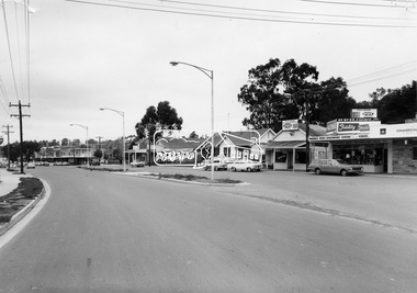
Photograph, Eltham - Main Road, showing shops between Arthur street and Dudley Street. Site of Woolworths (Aust.) Ltd, c.1967-c.1968, 1967
Properites along Main Road between Arthur Street and Dudley Street including ;L-R: Shire Hall and Shire Office, Photographer shop, Barber shop, Fire Station, Hardware shop and Commercial Bank of Australia. This photo forms part of a collection of photographs gathered by the Shire of Eltham for their centenary project book,"Pioneers and Painters: 100 years of the Shire of Eltham" by Alan Marshall (1971). The collection of over 500 images is held in partnership between Eltham District Historical Society and Yarra Plenty Regional Library (Eltham Library) and is now formally known as the 'The Shire of Eltham Pioneers Photograph Collection.' It is significant in being the first community sourced collection representing the places and people of the Shire's first one hundred years.Digital imagesepp, shire of eltham pioneers photograph collection, eltham, main road, shops -
 Tatura Irrigation & Wartime Camps Museum
Photograph, Chas Brady Story
Original photograph of Chas Brady's Store in Casey Street, Tatura. One of the very early stores in Tatura. Grocer, draper, general merchant. Also partly in photo, is a farm machinery store, Horsby, Reapers, Binders.Black and white photograph of Chas Brady Store in Casey Street, Tatura. Horse and cart, men and women and children outside store but names unknown.Chas Brady Store Casey Street Tatura.chas brady store tatura -
Glenelg Shire Council Cultural Collection
Book, E.N.T. HENRY, Historic Portland Street Names, 1972
Book of historic Portland street names, including their origin, location and significance. A street map of Portland is attached to inside of back cover. Semi gloss card covers, grey with red and blue print. Inside pages pale yellow, black print. Map of Portland white with black print.local history, street names, portland, directory -
 Linton and District Historical Society Inc
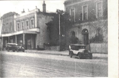
Photograph, Sussex Street, Linton, circa 1920
Somewhat blurry black and white copy of an original photograph which has been mounted on white card. View to the west of Sussex Street, Linton, showing the Grenville Shire Hall, Criterion House and Shepherd's store. The two cars shown parked in the street suggest the photograph was taken in the 1920s.shire hall linton, shire of grenville offices and hall, criterion house, shepherd's store, sussex street linton, buildings -
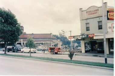 Ringwood and District Historical Society
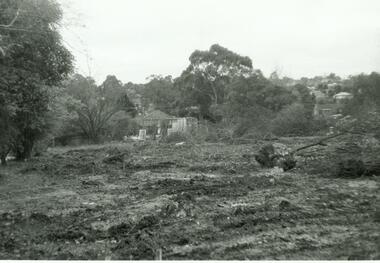
4 Coloured photographs numbered 10043 to 10046, Demolition of buildings in Adelaide Street -Ringwood. Circa 1960
Postcard size coloured photograph"Written on back of photograph" Demolition of buildings corner Adelaide Street. Early 1960's. K.T.Williams- Chemist -
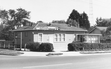 Ringwood and District Historical Society
Photograph, Kenlaurel Dance Studio, Corner Bourke and Ringwood Street, Ringwood - 1973. Formerly Winnington Private School
Written on backing sheet, "Dancing Studio 1973. Formerly Winnington Private School, corner Ringwood Street". -
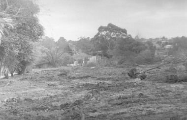 Ringwood and District Historical Society
Photograph, Houses demolished for Eastland parking. Ringwood Street near Miles Ave. - 1973
Written on backing sheet, "Houses demolished for Eastland parking. Ringwood Street near Miles Ave. - 1973". -
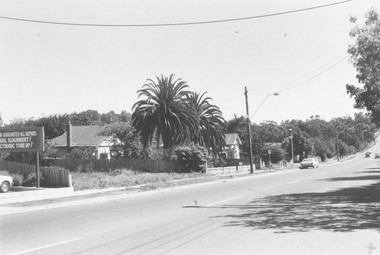 Ringwood and District Historical Society
Photograph, Warrandyte Road, east side, to Aird Street and bowling green. Jan. 1975
Written on back of photograph, "Warrandyte Road, east side, to Aird Street and bowling green. Jan. 1975". -
 Ringwood and District Historical Society
Photograph, Houses cleared away for Eastland parking. Ringwood Street on left. 1971
Written on back of photograph, "July 1971. Houses cleared away for Eastland parking. Ringwood Street on left." -
 Ringwood and District Historical Society
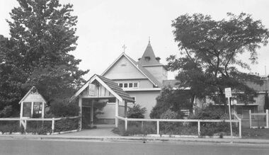
Photograph, St. Paul's Anglican Church when in Ringwood Street, Ringwood - 1963
Black and white photograph of church.Written on backing sheet, "1963 - Old C of E. S.E. corner of Ringwood Street, Civic Place" -
 Ringwood and District Historical Society
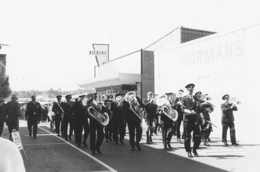
Photograph, Ringwood clocktower dedication Dec 1967 - Ringwood band leading march in Melbourne Street, Ringwood
Written on back of photograph, 'Ringwood band leading march to tower, 9/12/67 in Melbourne Street'. -
 Whitehorse Historical Society Inc.
Photograph, Britannia Street, Mitcham, 13/06/1986 12:00:00 AM
2 Coloured photos of Brittania Street, Mitcham. Looking North from Corner of Whitehorse Road. Shops on Western side of Britannia Street are located on the site of Barelli's shop, dwelling and bakehouse. To the north of these buildings and across a cobblestone lane now called Enterprise Way was the Salvation Army Citadel, .a further commercial building housing a printer. Erection of this building necessitated demolition of Barelli's stable and reclamation of its horseyard. The Salvation Army are now located on the Mitcham Road and Harrison Street corner.britannia street mitcham -
 Bacchus Marsh & District Historical Society
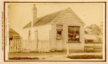
Photograph, Saddlery Shop of George Taylor Main Street Bacchus Marsh 1883
This image is one of a series of photographs taken by Melbourne based photographers Stevenson and McNicoll who visited Bacchus Marsh and its nearby districts between September and November 1883. George Taylor was in business in Bacchus Marsh from 1866. He built these premises in Main Street in 1868 and remained in business until 1888 when Samuel Painter brought the property and operated his own saddlery business. The location was later used for the State Savings Bank of Victoria and the Bank of New South Wales (Westpac). The location of this site in 2024 is 136 Main Street, Bacchus Marsh.Small sepia 'carte de viste' style unframed photograph on card with gold border framing photograph. Housed in the album, 'Photographs of Bacchus Marsh and District in 1883 by Stevenson and McNicoll'. The image shows a single storey timber building with a pitched roof. The front of the gable has an ornamental wooden fretwork design attached.The name 'Taylor' can be clearly seen above the front door. There is one large window. The roof appears to be slate and the building has one chimney. Outhouses can be seen to the left and right of the building. There is a picket fence to one side of the building and a post-and-rail fence to the other.Printed On the front: Stevenson & McNicoll. Photo. 108 Elizabeth St. Melbourne. COPIES CAN BE OBTAINED AT ANY TIME. On the back: LIGHT & TRUTH inscribed on a banner surmounted by a representation of the rising sun. Copies of this Portrait can be had at any time by sending the Name and Post Office Money Order or Stamps for the amount of order to STEVENSON & McNICOLL LATE BENSON & STEVENSON, Photographers. 108 Elizabeth Street, MELBOURNE. stevenson and mcnicoll 1883 photographs of bacchus marsh and district, saddleries, saddlers -
 Bacchus Marsh & District Historical Society
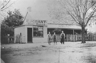
Photograph, C.J. Grant, Bootmaker's Shop, corner of Grant Street and Waddell Street, Bacchus Marsh, circa 1907-1909
Charles Grant opened a boot makers business on the northern corner of Grant Street and Waddell Street in 1907. The business was advertised as being in Maddingley Road. By early 1910 the business had moved to 'Ryan's Corner' on the corner of Main Street and Gell Street, Bacchus Marsh. The brick house behind the boot maker's shop was built for Alexander Murdoch in 1869. It was used as a residence, a boarding house and as part of a business by a number of different owners over many years. It was known as the Murdoch house and also as 'Links Cottage' when it was used as a boarding house. For most of the twentieth century it was used as a residence. It was demolished in 1997 to make way for new residences.Black and white photograph print. A reproduction of an original photograph which is mounted on board. The image shows a boot maker's business and a brick house behind it. Standing in front of the shop on the footpath are three men wearing aprons.boot makers bacchus marsh victoria, shops bacchus marsh, houses bacchus marsh -
 Wodonga & District Historical Society Inc
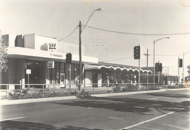
Photograph - Codling Collection 01 - Wodonga, High Street West - WESTPAC to Tooles Disposals, 1970s
Miss Olive Codling was a Foundation Member and a Life Member of the Wodonga Historical Society. Many of her prize-winning photos are held in the Society Collection. She also held a range of roles and committee positions in a wide range of Wodonga community organisations. These included the Horticultural Society, the Wodonga Arts Council, the Wodonga Camera Club and the Wodonga Lapidary Club. This photo collection is significant as it documents how the businesses and buildings in Wodonga have evolved and contributed to community throughout the 20th century.Wodonga, High Street West Businesses including Westpac, Wodonga Jewellers, Genevieve, Andrews Chemist and Tooles Disposals. In 2012, Westpac Wodonga is still located at 141 High Street with Wodonga Jewellers remains in the neighbouring premises. There is also a Nail salon and 2 vacant premises. Tooles Disposals on the corner of High Street and Stanley Street Wodonga Jewellers was opened by Gordon and Flora McWaters in 1951. Over the years it has occupied premises at 3 different locations in High Street. Tooles Disposals, formerly Tooles Motors was established in 1939. It was taken over from William Dobbie, Automotive Engineer who set up his business on this site about 1929. It was opened by Pat Toole and later taken over by his son Bill. The Disposals part of the business was expanded in 1963 and eventually took over the entire building. The central Wodonga building was sold in 2011 and Bill and his wife Debbie moved the stock to their warehouse in Bandiana. They operated from Bandiana while also focusing on online selling. The High Street building was demolished in 2013.wodonga businesses, high st wodonga, tooles disposals -
 Melbourne Tram Museum
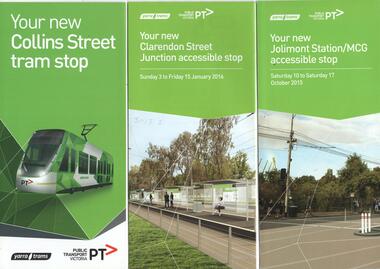
Pamphlet, Public Transport Victoria (PTV), "Your new Collins Street tram stop", "Your new Jolimont Station MCG accessible stop", "Your new Clarendon Street Junction accessible stop", 2015 to 2016
Set of three pamphlets advising of changes to tram services for the installation of various trams stops or track works. .1 - "Your new Collins Street tram stop" - advising of the proposed new super stops between Elizabeth St and Spencer St - and consultation Feb. 2015. - 3 fold DL. .2 - "Your new Jolimont Station MCG accessible stop" - 4 fold DL - Oct. 2015 - includes a map and details. .3 - "Your new Clarendon Street Junction accessible stop" - includes changes for the 12 day project early Jan. 2016 - 6 fold DL. Produced by Public Transport Victoria and Yarra Trams with VicRoads.trams, tramways, public transport, tram stops, collins st, jolimont jtn, mcg, clarendon st, southbank -
Glenelg Shire Council Cultural Collection
Photograph - Sheet of 12 contact prints of rephotographed photographs - Various Portland land marks, c. 1970
Sheet of 12 contact prints of rephotographed photographs: Identifying Numbers 5716 a, b, c, d, e, f, g, h, i, j, k, l Measurements for each print 3.2 x 5 cm (a) Julia Street (b) Lamb Inn (c) Britannia Hotel (d) British Fleet in Portland Bay (e) Warehouses Trangmar & Crouch, Corner Percy/Henty Streets (f) Builders Arms Hotel (g) Prospect (h) 3rd Baths (i) Henty Beach Cliffs (j) Old Portland Hospital (k) London Inn (l) Opening 3rd BathsFrom the front: (a) Julia Street (b) Portland Hotel (c) Britannia Hotel (d) British Fleet in Portland Bay Setp 30, 1891 (e) Trangmar & ....ush Store (f) Builders Arms Hotel (g) Prospect (h) Baths (i) Henty Beach (j) Portland Hospital (k) London Inn (l) Baths -
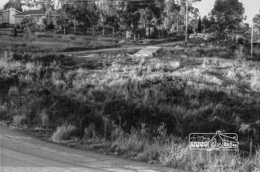
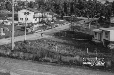
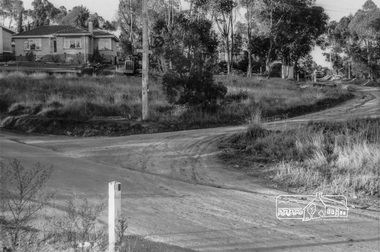 Eltham District Historical Society Inc
Photograph, Looking northeast up Alma Street from Para Road at intersection of Alma Street and Lees Road, Lower Plenty, c.July 1967, 1967
Packaged in "Filmpro King Size prints Definitely Better EST. 1918" envelope. Pencil notes: 36 shots $2.87 Eltham Shire J. McD and 19/7/67. Alma Street and Kett Street Lower Plenty c.July 1967.Black and white photographalma street, lees road, lower plenty, para road, houses, streets -
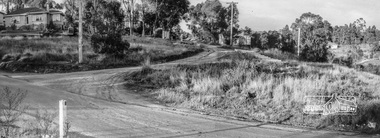 Eltham District Historical Society Inc
Photograph, Looking northeast up Alma Street from Para Road at intersection of Alma Street and Lees Road, Lower Plenty, c.July 1967, 1967
Packaged in "Filmpro King Size prints Definitely Better EST. 1918" envelope. Pencil notes: 36 shots $2.87 Eltham Shire J. McD and 19/7/67. Alma Street and Kett Street Lower Plenty c.July 1967.Digital composite of two black and white photographsalma street, lees road, lower plenty, para road, houses, streets -
 Eltham District Historical Society Inc
Photograph, Looking northeast up Alma Street from Para Road at intersection of Alma Street and Lees Road, Lower Plenty, c.July 1967, 1967
Packaged in "Filmpro King Size prints Definitely Better EST. 1918" envelope. Pencil notes: 36 shots $2.87 Eltham Shire J. McD and 19/7/67. Alma Street and Kett Street Lower Plenty c.July 1967.Black and white photographalma street, lower plenty, para road, houses, streets -
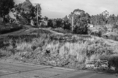
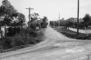
 Eltham District Historical Society Inc
Photograph, Looking southeast along Kett Street towards intersection with Alma Street, Lower Plenty, c.July 1967, 1967
Packaged in "Filmpro King Size prints Definitely Better EST. 1918" envelope. Pencil notes: 36 shots $2.87 Eltham Shire J. McD and 19/7/67. Alma Street and Kett Street Lower Plenty c.July 1967.Black and white photographlower plenty, houses, streets, kett street, alma street -
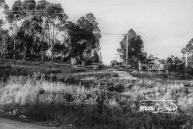
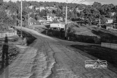
 Eltham District Historical Society Inc
Photograph, Looking west along Alma Street from Kett Street, Lower Plenty, c.July 1967, 1967
Packaged in "Filmpro King Size prints Definitely Better EST. 1918" envelope. Pencil notes: 36 shots $2.87 Eltham Shire J. McD and 19/7/67. Alma Street and Kett Street Lower Plenty c.July 1967.Black and white photographlower plenty, houses, streets, kett street, alma street -
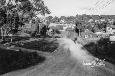
 Eltham District Historical Society Inc
Photograph, Looking towards the intersection of Kett Street with Main Road from 8 Kett Street, Lower Plenty, c.July 1967, 1967
Packaged in "Filmpro King Size prints Definitely Better EST. 1918" envelope. Pencil notes: 36 shots $2.87 Eltham Shire J. McD and 19/7/67. Alma Street and Kett Street Lower Plenty c.July 1967.Black and white photographlower plenty, houses, streets, kett street, main road -
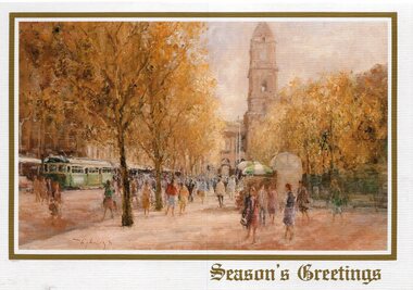 Melbourne Tram Museum
Drawing - Illustration, Australian Rotary Health Research Fund, "Swanston Street Melbourne", late 1980s
Illustration - colour engraving printed onto white card, titled "Swanston Street Melbourne" of a painting of a street scene in Swanston, looking north with the Town Hall and the City Square in the work. Painting by John Tiplady, produced to raise funds for the Australian Rotary Health Research Fund. Used for a Christmas Card.trams, tramways, swanston st, town hall, greetings cards