Showing 10934 items
matching land
-
 Port Melbourne Historical & Preservation Society
Photograph - Gate on Bridge Street side of Excelsior Hall, Port Melbourne, David Thompson, Jun 1998
On ending of RSL lease and therefore imminent sale and development of the land - Princes to Station at Bridge - David THOMPSON recorded exterior details of the building.Photo: gate, Bridge Street. From series of photos of Excelsior Hall ('Diggers' Hall'), RSL Port Melbourne branch headquarters 1948 - 1998. Made June 1998 by David THOMPSON.societies clubs unions and other organisations, excelsior hall, built environment, returned services league, rsl -
Port Melbourne Historical & Preservation Society
Photograph - Gate (detail) on Bridge Street side of Excelsior Hall, Port Melbourne, David Thompson, Jun 1998
On ending of RSL lease and therefore imminent sale and development of the land - Princes to Station at Bridge - David THOMPSON recorded exterior details of the building.Photo: detail gate, Bridge Street. From series of photos of Excelsior Hall ('Diggers' Hall'), RSL Port Melbourne branch headquarters 1948 - 1998. Made June 1998 by David THOMPSON.societies clubs unions and other organisations, excelsior hall, built environment, returned services league, rsl -
Port Melbourne Historical & Preservation Society
Photograph - Excelsior Hall from Station and Bridge Streets, Port Melbourne, David Thompson, Jun 1998
On ending of RSL lease and therefore imminent sale and development of the land - Princes to Station at Bridge - David Thompson recorded exterior details of the building.Photo: hall from Station and Bridge Streets. From series of photos of Excelsior Hall ('Diggers' Hall'), RSL Port Melbourne branch headquarters 1948 - 1998. Made June 1998 by David THOMPSON.societies clubs unions and other organisations, excelsior hall, built environment, returned services league, rsl -
Port Melbourne Historical & Preservation Society
Photograph - View from south, Excelsior Hall, Port Melbourne, David Thompson, Jun 1998
On ending of RSL lease and therefore imminent sale and development of the land - Princes to Station at Bridge - David THOMPSON recorded exterior details of the building.Photo: view from south, showing Station Hotel (redeveloped as residences) and caretaker's cottage at Dispensary (110 Station Street). From series of photos of Excelsior Hall ('Diggers' Hall'), RSL Port Melbourne branch headquarters 1948 - 1998. Made June 1998 by David THOMPSON.societies clubs unions and other organisations, excelsior hall, built environment, returned services league, rsl -
Tatura Irrigation & Wartime Camps Museum
Poster, Tatura Subdivision, 1928
Hogans Estate was privately owned land on Tatura's north side as opposed tot he government sub division when Tatura was founded.Large Tatura subdivision poster of 1928 advertising large area north of Hogan Street, named Hogan Estate. Clear plan of subdivisions. Bold print in red and blue.Great subdivision sale. Hogans Estate Tatura. Saturday 18 August 1928. J. McNamara & Co.tatura subdivision, hogans estate -
National Wool Museum
Invoice
Subscription invoice for "Country Life and Stock and Station Journal", made out to Mr J H Landers, Lanauria, Gulargambone, February 1947 .farming agriculture, country life newspaper co. ltd, farming, agriculture -
 Ballarat Heritage Services
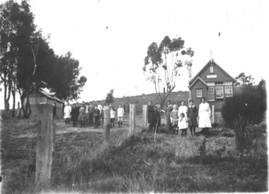
Pamphlet - Photograph - Black and White, Yandoit Hill State School (No 2052)
The land for this school was donated by Carlo Gervasoni. After the closure of the school the building was moved to the corner of Main Road and Seventh Street, Hepburn Springs.A number of students in front of a weatherboard school at Yandoit Hill. yandoit, yandoit hill state school, yandoit hills, yandoit creek, education -
Unions Ballarat
Captain Cook in Australia: extracts from the journals of Captain James Cook giving a full account in his own words of his adventures and discoveries in Australia (Don Woodward Collection), Cook, James, 1969
James Cook's journals around the time of his voyage to the east coast of New Holland (Australia) and a visit to Van Diemen's Land (Tasmania).Biographical interest. Historical - Australia.Book; 192 pages. Dust jacket: white background; colour artwork with ship; black and green text; editor's name and title."Happy Birthday, George 1973"btlc, ballarat trades hall, ballarat trades and labour council, cook, captain james, tasmania - van diemen's land, australia - new holland, australia - explorers -
 City of Ballarat Libraries
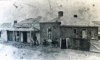
Photograph - Card Box Photographs, Temperance Store, East Ballarat circa 1860
The store was located in Humffrary Street North. A land grant was given to William Lane on condition he maintained the store for miners and wood cutters.temperance store, william lane, building, commerical, persons, humffray street north -
Robin Boyd Foundation
Document, McCay & Thwaites (Barristers & Solicitors), 1957
Letters to Robin Boyd (14th and 26th August, 1957) regarding acquisition and contract for purchase of land at 290 Walsh St, South Yarra.Five pages, including two letters, plans and rough calculation. -
 Melton City Libraries
Photograph, Staughton Vale, 1984
Staughton family owned Exford. Eynesbury and Brooklyn Estates. Prominent family with civic connection in Melton holding very large areas of land The Melton and District Historical Society visited Staughton Vale estate in 1984.local architecture, local identities -
 City of Kingston
Pamphlet - Colour, Highett Town, 1888
Sales plan for land in the suburb of Highett, bounded by Highett Road, Worthing Terrace and the railway line, and incorporating Major Street and Train Street.The developing urban area of Highett within the City of Kingston. This land sale pamphlet illustrates the subdivision of land within the municipality and the changing demographic of the district as new houses are constructed close to infrastructure.Colour pamphlet advertising for private sale the Station Entrance Estate, Highett. Incorporates a map of the estate bordered by Wickham Road, Railway Parade, Highett Road and Point Nepean Road.land sales, highett -
 Lakes Entrance Historical Society
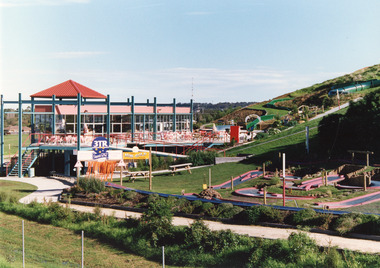
Photograph - Kinkuna, 2009
Kinkuna Amusement Park was opened 19 December 1987, closed 2002, building demolished or removed, land sold and subdivided into residential allotments.Copy colour photographic print showing Kinkuna Amusement Park on Princes Highway, owned by Joe and Shirley Walters. Photo shows main building and restaurant, mini golf, long taboggan on hill, garden and other attractions. Lakes Entrance Victoriaentertainment, recreation -
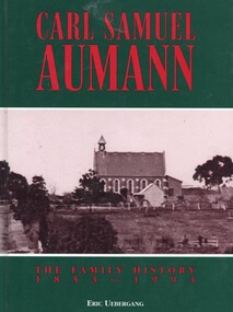 Ringwood and District Historical Society
Book, Carl Samuel Aumann - The Family History 1853-1993, 1993
Hard cover book by Eric Uebergang. This book pays tribute to the Aumann pioneers in Australia and records details of their lives and those of their descendants to the year 1993, following a meeting of descendants in East Doncaster in 1992 and a family reunion in 1993 at the Lutheran Church in Doncaster, Victoria."Dedicated to the Memory of Carl Samuel Aumann, who with his family, made the arduous journey to Australia, to an unknown land. Known to the early German families of Doncaster as "Father" Aumann. Their hard work made the foundation for a prosperous country." Front cover: Bismark Street (Victoria Street), Doncaster. Lutheran Church and the home of Carl Aumann alongside the church. -
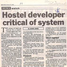 Ringwood and District Historical Society
Newspaper, Scrapbook Clipping, Library Collection, Ringwood, Victoria
Newspaper Clipping from "The Mail", 23-2-1993. Hostel developer critical of system. Article by Janine JonesThe owner of land approved for a controversial aged care development at Heatherdale Rd, Vermont, has hit out at objectors to the project. Ringwood Council approved revised plans for the hostel at 177 Heatherdale Rd, Vermont, after a year of negotiations with the applicants, Lois and Bob McDonough. Council received 14 objections from neighbouring residents to the development. -
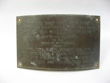 City of Whittlesea
Plaque (item) - Norris Bank Reserve Plaque, Guthrie Family Plaque
May all who visit this park / enjoy the happiness and pleasure / we all had whilst living here / a gift to the residents / of this / Shire of Whittlesea / from / Edna, Vita, Beryl, Hubert, Les, Roy / Ivan, Wes, Clive & Alan the family of the late William & Barbara Guthrie / who owned and farmed this land / March 1981norris bank reserve -
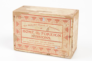 Uniting Church Archives - Synod of Victoria
Giving Box, Methodist Church of Australasia Home & Foreign Missions Giving Box, ?1930s - 1950s
Wooden giving box Front: "The Methodist Church of Australasia, Home & Foreign Missions. Go Ye Into All the World And Preach the Gospel to Every Creature". Top: "freely have Ye Received! Freely Give". Side 1: "Home Mission: To Spread Scriptural Holiness Through the Land". Side 2: "Foreign Mission: The Idols He Shall Utterly Abolish".methodist church of australasia home & foreign affairs -
![Fern Grove, near Mount Munday / [by] Nicholas Caire, circa 1876](/media/collectors/550653872162f11fb04854aa/items/57774d68d0cdd10a5c144296/item-media/57774e07d0cdd10a5c148099/item-fit-380x285.jpg) Kew Historical Society Inc
Kew Historical Society IncPhotograph, Anglo-Australasian Photographic Company, Fern Grove, near Mount Munday, c. 1876
Nicholas Caire was born on Guernsey in the Channel Islands in 1837. He arrived in Adelaide with his parents in about 1860. In 1867, following photographic journeys in Gippsland, he opened a studio in Adelaide. From 1870 to 1876 he lived and worked in Talbot in Central Victoria. In 1876 he purchased T. F. Chuck's studios in the Royal Arcade Melbourne. In 1885, following the introduction of dry plate photography, he began a series of landscape series, which were commercially successful. As a photographer, he travelled extensively through Victoria, photographing places few of his contemporaries had previously seen. He died in 1918. Reference: Jack Cato, 'Caire, Nicholas John (1837–1918)', Australian Dictionary of Biography, National Centre of Biography, Australian National UniversityAn original, rare photograph from the series 'Views of Victoria: General Series' by the photographer, Nicholas Caire (1837-1918). The series of 60 photographs that comprise the series was issued c. 1876 and reinforced a neo-Romantic view of the Australian landscape to which a growing nationalist movement would respond. Nicholas Caire was active as a photographer in Australia from 1858 until his death in 1918. His vision of the Australian bush and pioneer life had a counterpart in the works of Henry Lawson and other nationalist poets, authors and painters.Albumen silver photograph mounted on board‘The subject of this illustration is situated in one of the wildest and most romantic places in the Gipps Land ranges, about midway between Mount Munday and Mount Juliet. The foliage in this locality is very luxuriant, comprising mostly Fern Trees which are interwoven with various descriptions of grasses and stunted Fern leaves. Beneath this mass of vegetation flows a branch of the Contentment Creek.’landscape photography - victoria, nicholas caire, ferngrove - victoria -
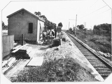 Ringwood and District Historical Society
Photograph, Constructing Ringwood East railway station - 1925
Black and white photographs - 2 copies, same sizeTyped below one photograph, "Constructing Ringwood East railway station - 1925". Backing sheet of other photograph reads, "Ringwood East railway station - Higher than Croydon or Ringwood. Photo taken from Ringwood East railway station. Sub-division plan land sale Ringwood East Railway Station Estate 1925?" -
 Ringwood and District Historical Society
Document - Plan of Subdivision, Part of Crown Allotment 31B, Parish of Warrandyte - 1965
Map showing residential allotments numbered 1, 2, 4 and 5, on Through Road, Ringwood, Vic., with property dimensions, including weatherboard house and galvanised iron garage on lot 2.Kirkpatrick & Webber, Licensed Surveyors, Civil Engineers & Town Planners, Maroondah Highway, Ringwood, Telephone 8700321. Ref 3438C. Date 4th December, 1964. Amended 19th July, 1965. Notation: "The land coloured blue is a drainage and sewerage easement. Levels are to Board of Works Datum. Lot number 3 has been omitted." -
 Kiewa Valley Historical Society
Folder - Clare Roper No. 7, Items of Interest
Clare Roper was a resident of the Kiewa Valley and belonged to the Kiewa Valley Historical Society.Clare Roper collected and collated items of historical interest for the Kiewa Valley Historical Society.Grey plastic front and back cover with black spiral spine with 24 clear plastic sleeves / pages plus 2 sleeves empty. Includes: Roper Family. Thomas Mitchell C.M.G.. North Eastern Dairy Company. Johann Gottfried Scholy's History. Rutherglen's Early Days.The Viticulture College. Botharambo. Pledge of Loyalty (to the Queen). North East Historical Societies. The Land Act 1883. Protection of the Aborigines 1886.clare roper; scrap book -
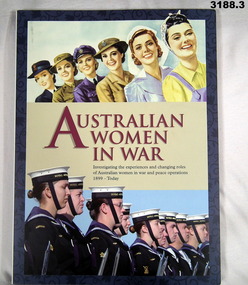 Bendigo Military Museum
Mixed media - PACKAGE - TEACHER'S AID BOOK, DVD & CD ROM, Australian Department of Veterans Affairs, Australian Women in War, 2008
.1) Book. Hard cover. Printed images of WWII women in armed forces, nursing & land army. Bottom image is photo of modern females in RAN. Red & blue printing. 108 pages, illustrated photos & maps. .2) DVD - Australian Government Department Veterans Affairs. Changing roles of women, 1899 - today. Images identical to front cover. .3) CD Rom identical cover to .2) above.books reference/military, audio-visual technology - audio/visual accessories, illustrations-prints, military history -
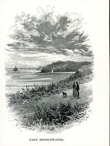 Glenelg Shire Council Cultural Collection
Artwork, other - Illustration, CAPE BRIDGEWATER, n.d
Illustration. Taken and cut from a book. Image is a oval The view is looking from land across a path with the sea and cliffs. Man and woman with dog on lead, walking down path. A large sailing vessel is visible anchored to the left with a further ship in the distance to the right. A smaller sailing ship with a white sail sits just inside the first cape. Sky appears murky textured with clouds. Printed at the bottom CAPE BRIDGEWATER.Front: 'CAPE BRIDGEWATER' - printed, lower frame.cape bridgewater -
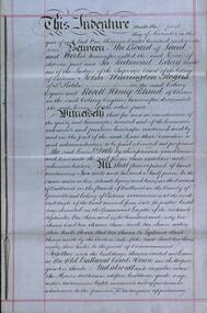 Federation University Historical Collection
Document, Lease for the Former Ballarat Circuit Court House, Lydiard Street, Ballarat, 1870 and 1877, 05/1870; 1877
The Ballarat School of Mines opened in the former Ballarat Circuit Court House in 1870. The court house was demolished in 1915 to make way for the Ballarat Technical Art School. The Ballarat School of Mines is a predeccessor of Federation University Australia..1) Handwritten agreement on blue paper with green thread. The agreement is between the Board of Land and Works and Redmond Barry and others concerning a seven year lease of the former Ballarat Circuit Court House for use as a mining school (the Ballarat School of Mines). .2) Four lined fooscap pages relating to specifications of several works required to the Old Court House. .3) Rough notes on proposed lease of the Court House.lease, former ballerat circuit court house, redmond barry, legal, crown solicitor, gurner, robert davidson, warrington rogers, john warrington rogers, william warrington rogers, rivett henry bland, p. saunders, james williams, ballarat school of mines, ballarat school of mines establishment -
 Bendigo Historical Society Inc.
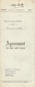
Document - H.A. & S.R. WILKINSON COLLECTION: CONTRACT OF SALE
Agreement to let and take dated 18th September, 1954 between Mr. F.C. Wilson (landlord) and Mr. C.C. Ross (tenant) the landlord lets to the tenant the land and premises described in residence area No. 5446 being the property of the landlord at Bellevue Road, Bendigo at the weekly rental of 2 pounds 10 shillings payable fortnightly in advance from the 18th September, 1954. Issued by C. Cohen, Solicitor, Pall Mall, Bendigoorganization, business, h.a. & s.r wilkinson real estate -
 Bendigo Historical Society Inc.
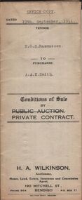
Document - H.A. & S.R. WILKINSON COLLECTION: CONTRACT OF SALE
Conditions of sale by private contract dated 19th September, 1931 between E.G.S. Rasmussen (seller) and A.A.K. Smith (buyer) for land situate 213-215 Mundy Street, Bendigo being part of Crown allotment 5 section 12C described in deed of conveyance, memorial No. 959 book No. 527, together with the right of carriage way described in the deed of conveyance, together with all buildings. Price 955 pounds. Office copyorganization, business, h.a. & s.r wilkinson real estate -
 Bendigo Historical Society Inc.
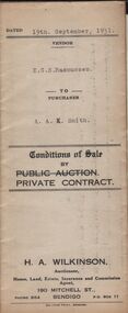
Document - H.A. & S.R. WILKINSON COLLECTION: CONTRACT OF SALE
Conditions of sale by private contract dated 19th September, 1931 between E.G.S. Rasmussen (seller) and A.A.K. Smith (buyer) for land situate 213-215 Mundy Street, Bendigo being part of Crown allotment 5 section 12C described in deed of conveyance, memorial No. 959 book No. 527, together with the right of carriage way described in the deed of conveyance, together with all buildings. Price 955 pounds. Vendor copy.organization, business, h.a. & s.r wilkinson real estate -
 Bendigo Historical Society Inc.
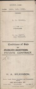
Document - H.A. & S.R. WILKINSON COLLECTION: CONTRACT OF SALE
Conditions of sale by private contract dated 14th October, 1935 between W.G. Brooks (seller) and W.A. Swift the Younger (buyer) for land situate No. 293 King Street, Bendigo being Crown allotment 2 section 43A described in Crown grant volume 3020 folio 603887, together with weatherboard dwelling and all sundry. Also electric light fittings, bath, copper and troughs. Price 255 pounds.organization, business, h.a. & s.r wilkinson real estate -
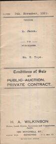 Bendigo Historical Society Inc.
Document - H.A. & S.R. WILKINSON COLLECTION: CONTRACT OF SALE
Conditions of sale by private contract dated 8th November, 1929 between A. Jacka (seller) and W. V. Tope (buyer) for land situate corner McKenzie and Wade Streets, Golden Square described in certificate of registration as residence area no. ? Together with 5-roomed weatherboard dwelling and all sundry, also gas stove, wood stove. Electric light fittings, bath, hand basin, copper and troughs. Price 620 pounds.organization, business, h.a. & s.r wilkinson real estate -
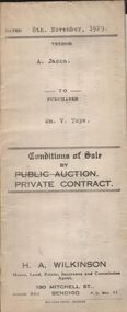 Bendigo Historical Society Inc.
Document - H.A. & S.R. WILKINSON COLLECTION: CONTRACT OF SALE
Conditions of sale by private contract dated 8th November, 1929 between A. Jacka (seller) and W. V. Tope (buyer) for land situate corner McKenzie and Wade Streets, Golden Square described in certificate of registration as residence area no. ? Together with 5-roomed weatherboard dwelling and all sundry, also gas stove, wood stove. Electric light fittings, bath, hand basin, copper and troughs. Price 620 pounds.organization, business, h.a. & s.r wilkinson real estate