Showing 10936 items matching " land"
-
 City of Moorabbin Historical Society (Operating the Box Cottage Museum)
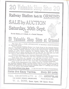
Article - Advertisement for shop sites on North Road at the Ormond Station, 1922
The train line from the city to Frankston was electrified in 1922 which intensified the sale in the municipality of Moorabbin, particularly land which was in the vicinity of the railway stations.Example of the progress of the Municipality of MoorabbinAdvertising flyer for auction of real estate sales - plan of building blocks for saleAdvertisement for shop sites on North Road at the Ormond Station - 20 Shop sites - Auction 30 September 1922north road, ormond, moorabbin -
 City of Moorabbin Historical Society (Operating the Box Cottage Museum)
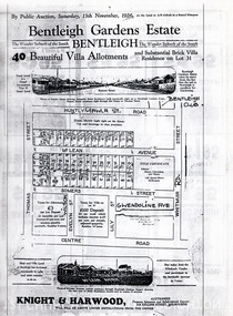
Flyer - Bentleigh Gardens Estate, Bentleigh, 1926
The train line from the city to Frankston was electrified in 1922 which intensified the sale in the municipality of Moorabbin, particularly land which was in the vicinity of the railway stations.Example of the progress of the Municipality of MoorabbinPhotocopy of advertising flyer for auction of real estate sales - plan of building blocks for saleBentleigh Gardens Estate, Bentleigh - 40 housing allotments - Auction Saturday 13 November 1926huntly road (now gawla st), mclean avenue, somers street, thomas street, bentleigh, real estate, auction -
 City of Moorabbin Historical Society (Operating the Box Cottage Museum)
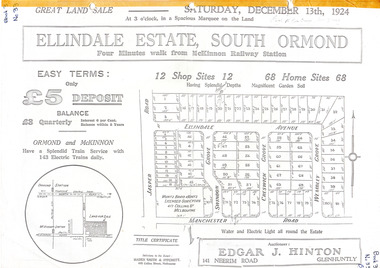
Flyer - Ellindale Estate, South Ormond, 1924
The train line from the city to Frankston was electrified in 1922 which intensified the sale in the municipality of Moorabbin, particularly land which was in the vicinity of the railway stations.Example of the progress of the Municipality of MoorabbinAdvertising flyer for auction of real estate sales - plan of building blocks for salePhotocopy of advertising brochure and two photocopies of advertisements for the auction of Ellindale Estate, South Ormond on 13 December 1924 consisting of 12 shop sites and 68 home sitesjasper road, swindon grove, creswick grove, wembley grove, ellindale ave, ormond, mckinnon, real estate, auction -
 City of Moorabbin Historical Society (Operating the Box Cottage Museum)
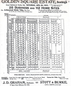
Flyer - Golden Square Estate, Bentleigh, 1923
The train line from the city to Frankston was electrified in 1922 which intensified the sale in the municipality of Moorabbin, particularly land which was in the vicinity of the railway stations.Example of the progress of the Municipality of MoorabbinAdvertising flyer for auction of real estate sales - plan of building blocks for saleGolden Square Estate, Bentleigh 25 business and 112 home sites for auction Saturday April 28 1923centre road, brewers road, jasper road, robert street, mitchell street, daley street, bendigo avenue, bentleigh, real estate, auction -
 City of Moorabbin Historical Society (Operating the Box Cottage Museum)
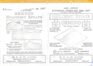
Flyer - Hillcrest Estate, Ormond, 1927
The train line from the city to Frankston was electrified in 1922 which intensified the sale in the municipality of Moorabbin, particularly land which was in the vicinity of the railway stations.Example of the progress of the Municipality of MoorabbinPhotocopy of advertising flyer for auction of real estate sales - plan of building blocks for saleHillcrest Estate, Ormond - 26 Home sites for auction Saturday 26 February 1927.parker street, holloway street, wild cherry road, wallen road, florence street, wimmera street, leila road, real estate, ormond, auction -
 City of Moorabbin Historical Society (Operating the Box Cottage Museum)
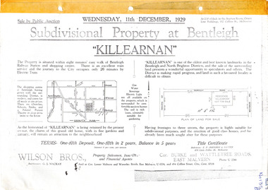
Flyer - Killearnan Estate, McKinnon, 1929
The train line from the city to Frankston was electrified in 1922 which intensified the sale in the municipality of Moorabbin, particularly land which was in the vicinity of the railway stations.Example of the progress of the Municipality of MoorabbinSubdivisional plan and advertisements for the sale of "Killearnan" Estate, Bentleigh "Killearnan" Estate, Bentleigh - Auction 11 December 1929thomas street, yawla street, huntley road, whitmuir road, mckinnon, bentleigh, real estate, auction -
 City of Moorabbin Historical Society (Operating the Box Cottage Museum)
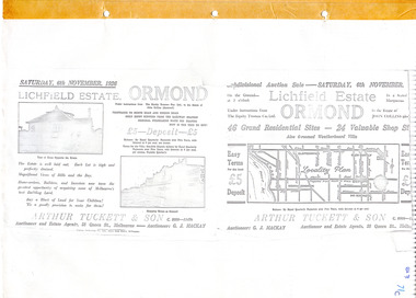
Flyer - Lichfield Estate, Ormond, 1926
The train line from the city to Frankston was electrified in 1922 which intensified the sale in the municipality of Moorabbin, particularly land which was in the vicinity of the railway stations.Example of the progress of the Municipality of MoorabbinPhotocopy of advertising flyer for auction of real estate sales - plan of building blocks for saleLichfield Estate, Ormond Auction Saturday 6 November 1926 - 46 residential sites & 24 shop siteswalnut street, collins street, north road, logan ave, ormond, real estate, auctions -
 City of Moorabbin Historical Society (Operating the Box Cottage Museum)
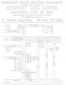
Flyer - McKinnon Road Estate, McKinnon, 1924
The train line from the city to Frankston was electrified in 1922 which intensified the sale in the municipality of Moorabbin, particularly land which was in the vicinity of the railway stations.Example of the progress of the Municipality of MoorabbinAdvertising flyer for auction of real estate sales - plan of building blocks for saleMcKinnon Road Estate, McKinnon Auction 26 April 1924 - 17 shop sites & 21 villa sitesgraham ave, prince edward ave, station street, mckinnon road, mckinnon, real estate, auctions -
 City of Moorabbin Historical Society (Operating the Box Cottage Museum)
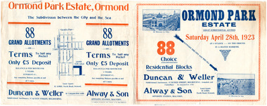
Flyer - Ormond Park Estate, Ormond, 1923
The train line from the city to Frankston was electrified in 1922 which intensified the sale in the municipality of Moorabbin, particularly land which was in the vicinity of the railway stations.Example of the progress of the Municipality of MoorabbinAdvertising flyer for auction of real estate sales - plan of building blocks for saleOrmond Park Estate, Ormond Auction Saturday 28 April 1923 - 88 residential blocks54jasper road, manchester road (now mckinnon road), hill street (now hall sreet), jasper street (now lewis street), real estate, auction, mckinnon, ormond -
 City of Moorabbin Historical Society (Operating the Box Cottage Museum)
Flyer - Ozone Hill Estate, Cheltenham, 1923
The train line from the city to Frankston was electrified in 1922 which intensified the sale in the municipality of Moorabbin, particularly land which was in the vicinity of the railway stations.Example of the progress of the Municipality of MoorabbinPhotocopy of Advertising flyer for sale of real estate sales - plan of building blocks for saleOzone Hill Estate, Cheltenham 41 choice residential allotments.victor avenue, weatherall road, cheltenham, real estate, auction -
 City of Moorabbin Historical Society (Operating the Box Cottage Museum)
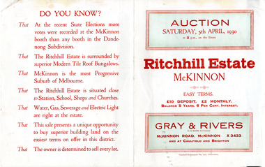
Flyer - Ritchill Estate, McKinnon, 1927
The train line from the city to Frankston was electrified in 1922 which intensified the sale in the municipality of Moorabbin, particularly land which was in the vicinity of the railway stations.Example of the progress of the Municipality of MoorabbinAdvertising flyer for auction of real estate sales - plan of building blocks for saleRitchill Estate, McKinnon, auction Saturday 5 April 1930lysbeth street, amelia st, murray road, mckinnon, auction, real estate, moorabbin -
 City of Moorabbin Historical Society (Operating the Box Cottage Museum)
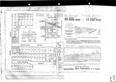
Flyer - Sunny Hill Estate, Carnegie, 1924
The train line from the city to Frankston was electrified in 1922 which intensified the sale in the municipality of Moorabbin, particularly land which was in the vicinity of the railway stations.Example of the progress of the Municipality of MoorabbinAdvertising flyer for auction of real estate sales - plan of building blocks for saleSunny Hill Estate in Carnegie - Ormond District Auction 46 Home sites - 14 Shop sites Auction 9 February 1924rigby ave, leila rd, koornanag road, grandview grove, oakleigh road, mckinnon, ormond, carnegie -
 Hume City Civic Collection
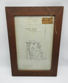
Plans, SUNBURY RESERVE PARISH OF HOLDEN
This object is a plan of a proposed recreation ground at Munro's. This was unfenced land between Evans and Barkly Streets adjacent to the Asylum boundary, now Jacksons Hill.A wooden framed plan of a proposed recreation ground.sunbury, sunbury asylum, george evans collection -
 Hume City Civic Collection
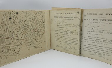
Correspondence Book, c1890s
A book with printed perforated pages to send one half to owner of property demanding outstanding payment of rates prior to Council taking possession of land.A mottled blue and brown hard cover book with black spine. Printed and handwritten pages. Printed pattern very worn on front and back covers."Shire of Bulla/Notice of Intention..."1890s, shire of bulla, george evans collection -
 Whitehorse Historical Society Inc.
Article, Parkswide Environmental Education Program, Aug 2023
Whitehorse has had an Environment Education Program for almost 40 years.non-fictionWhitehorse has had an Environment Education Program for almost 40 years.meagher dorothy, parkswide environmental education program -
 Rutherglen Historical Society
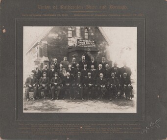
Photograph - Image, Alf L. Bowden, The Studio, Union of Rutherglen Shire and Borough, 1921
The building is the old Shire Hall (formerly a Church) in High Street. Roy Ready Senior bought the land and building and built his house with it as a part.Black and white photograph, mounted on cardboard, of a number of men in front of a building labelled Rutherglen Shire Office. Printed at top of mount: "Union of Rutherglen Shire and Borough | Date of Union: December 15, 1920. dissolution of Combined Councils: August 25, 1921." Complete list of individual names printed at bottom of mount. At bottom right of mount: "Alf L Bowden, The Studio, Corowa, N.S.W." Note from donor pasted on back of mount.rutherglen shire, rutherglen borough, shire buildings, rutherglen shire councillors, roy ready -
 Port Fairy Historical Society Museum and Archives
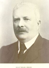
Photograph, Cr AF Molan Shire of Belfast President 1892-93
Councillor AF Molan owned land in Crossley close to where the Shamrock Hotel was built. The Council held it’s meetings at this hotel for some time.Black and white portraitgovernment, belfast, president, portrait, shire, municipal, local-government, cr af molan -
 Friends of Ballarat Botanical Gardens History Group
Work on paper - Ballarat Botanic Gardens - Gordon Cottage, Minutes, Ordinary Meeting of Council 20/2/1989, 20/2/1989
5 points are made about Adam Lindsay Gordon Cottage concerning the 'reservation of land, responsibility for the Cottage, restoration of the Cottage and notification of Council approval.This document is proof of Council's approval for the responsibility and restoration of the Adam Lindsay Gordon Cottage in 1989.1 page of typingDate 20/2/1989 stamped righthand top corner. 2 sections 1.4 and 1.6 crossed out diagonally. "Delegation and an illegible word written above item 1.5.john garner, doctor, john garner collection, friends of ballarat botanical gardens, adam lindsay gordon cottage, ymca, y's men's club, gordon cottage committee, australian poet, restoration of the adam lindsay gordon cottage, ballarat city council., ballarat botanical gardens, gardens, ballarat -
 City of Kingston
Pamphlet - Colour, T. H. Ould Publishing Co, The Ridge Estate, Cheltenham, c. 1930
Sales plan for land in the suburb of Cheltenham, bounded by Johnston Street, Silver Street and Cavanagh Street, incorporating lots on either side of Sunray Avenue.The developing urban area of Cheltenham within the City of Kingston. This land sale pamphlet illustrates the subdivision of land within the municipality and the changing demographic of the district as new houses are constructed close to infrastructure.Colour pamphlet advertising for sale lots in The Ridge Entrance Estate, Cheltenham. Incorporates a map of the estate bordered by Johnston Street, Silver Street and Cavanagh Street, including subdivision lots on either side of Sunray Avenueland sales, estate, cheltenham -
 City of Kingston
Pamphlet - Colour, Stillwell and Co, The Hill Estate, Highett, 1917
Sales plan for land in the suburb of Highett, bounded by Point Nepean Road and including Sandford Street, Turner Road, Alfred Street and Peace Street.The developing urban area of Highett within the City of Kingston. This land sale pamphlet illustrates the subdivision of land within the municipality and the changing demographic of the district as new houses are constructed close to infrastructure.Colour pamphlet advertising for sale at auction The Hill Estate, Highett. Incorporates a map of the estate bordered by Point Nepean Road and including Sandford Street, Turner Road, Alfred Street and Peace Street.Handwritten in grey pencil on subdivision map next to subdivisions 91, 92, 93, 106, 107 and 108: x Handwritten in grey pencil on back cover: The / Hill Estate / Highettland sales, estate, highett -
 Lakes Entrance Historical Society
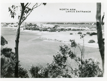
Postcard - North Arm Lakes Entrance, 1945c
Photo taken soon after extensive dredging operations when tons of sand were dumped on low lying land at western end of town.Black and white small format postcard of the North Arm. It shows the township between North Arm and Cunninghame Arm. Lakes Entrance VictoriaNorth Arm Lakes Entrancewaterways, topography -
 Eltham District Historical Society Inc
Newsletter, Newsletter, No. 5, March 1979
Contents: • Annual General Meeting • Early land sale documents • Recent activities • Recognition of pioneers and local people • Society speakers • Committee meeting The Shire of Eltham Historical Society was formed in October 1967. The first newsletter of the Society was issued May 1978 and has been published continuously ever since on a bi-monthly basis. With the cessation of the Shire of Eltham in late 1994, the Society's name was revised to Eltham District Historical Society and this name first appeared with issue No. 103, July 1995. The collection of the Society's newsletters provides a valuable resource on the history of the Society's activities, office bearers and committee members, guest speakers and subjects of historical interest pertinent to the former Shire of Eltham and the Eltham District.A4 photocopied newsletter distributed to membersnewsletter, eltham district historical society, shire of eltham historical society -
 The Beechworth Burke Museum Research Collection
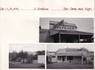
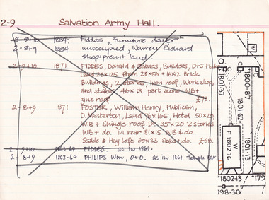
Card (Series) - Index Card, George Tibbits, Camp Street (Cnr Camp & High Streets), Beechworth, 1976
George Tibbits, University of Melbourne. Faculty of Architecture, Building and Town & Regional PlanningIndex system that support the research for Beechworth : historical reconstruction / [by] George Tibbits ... [et al]Arranged by street names of BeechworthEach index card includes: street name and number of property, image of property, allotment and section number, property owners and dates of ownership, description of the property according to rate records, property floor plan with dimensions.beechworth, george tibbitsbeechworth, george tibbits -
 Warrnambool and District Historical Society Inc.
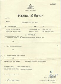
Document, Australian Army Statement of Service, C 1976
He served from December 1941 to July 1942 in the Citizen Military Forces and from July 1942 to September 1944 in the Australian Imperial Forces. His reason for discharge was reserved occupation. He held the rank of corporal in 26th Motor regiment. He was born in Colac 19/11/1919 to Ernest Swan and Daisy Johnson. He died 04/08/2009 and is buried at the Warrnambool cemetery. During his life he farmed a soldiers’ settlers block in the Grasmere area, north of Warrnambool. The soldiers' settlement program was instigated after both world wars whereby land was made available to returning soldiers. Some of the land was Crown land and some was acquired. This document is an official statement of his service.This document has social significance and interest as it is representative of thousands of local men who served in World War 2. It is a link also to the Soldiers' settlement programCream paper with black text. Personal details of Ernest Henry Swan have been typed into fields. text in the centre of the reverse.Signed E H Swan. date of issue is 11/08/1976.Army number VX88010.warrnambool, e h swan, e h swan statement of service -
 Bayside Gallery - Bayside City Council Art & Heritage Collection
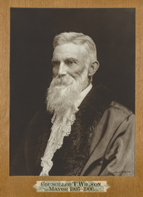
Photograph - sepia photograph, Johnstone O'Shannessy & Co. Falk, Councillor T. Wilson, Mayor of Brighton 1905-06, c. 1906
Thomas Wilson (1838-1923) was a local councillor in Brighton (in its three phases as Borough, Town and City) representing the central ward over a 57-year period, firstly in 1866-79 and again in 1894-1923. He was elected as mayor seven times, as Borough of Brighton in 1869, Town of Brighton in 1895-96, 1905 and 1912-13, and was the second Mayor of the City of Brighton in 1919. He was also a land speculator and both Wilson and his father William Wilson owned considerable land in the area. William Wilson sold land on the corner of Wilson and Carpenter Streets to the Council for its Town Hall. Wilson also represented the council on the Melbourne and Metropolitan Board of Works, of which he had been a member for 22 years.portrait, councillor, mayor, brighton, metropolitan board of works, borough of brighton, town of brighton, city of brighton, central ward, municipality, land speculator, william wilson, thomas wilson, cr. t wilson -
 The Beechworth Burke Museum Research Collection
Card (Series) - Index Card, George Tibbits, High Street, Beechworth, 1976
George Tibbits, University of Melbourne. Faculty of Architecture, Building and Town & Regional PlanningIndex system that support the research for Beechworth : historical reconstruction / [by] George Tibbits ... [et al]Arranged by street names of BeechworthEach index card includes: street name and number of property, image of property, allotment and section number, property owners and dates of ownership, description of the property according to rate records, property floor plan with dimensions.beechworth, george tibbitsbeechworth, george tibbits -
 The Beechworth Burke Museum Research Collection
Card (Series) - Index Card, George Tibbits, Ford Street, Beechworth, 1976
George Tibbits, University of Melbourne. Faculty of Architecture, Building and Town & Regional PlanningIndex system that support the research for Beechworth : historical reconstruction / [by] George Tibbits ... [et al]Arranged by street names of BeechworthEach index card includes: street name and number of property, image of property, allotment and section number, property owners and dates of ownership, description of the property according to rate records, property floor plan with dimensions.beechworth, george tibbitsbeechworth, george tibbits -
 Phillip Island and District Historical Society Inc.
Photograph, Early 1920's
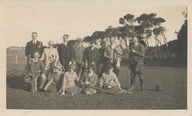
One of 5 photographs donated by Lyn Chambers & Frank Dominick - Wonthaggi Historical Society The following information was sent by a reader of VC for which we are very thankful. The golf course in San Remo was opened in 1922 and was on the land adjacent to Ocean Grove where Griffiths point lodge and Davis Point road now stand. One hole was placed on the flat land on the beach. There were red flags and the cows used to eat them. Black & White photograph of a group of people with their golf clubs. Noted on back of photo "San Remo Golf Links". A question mark re location as it seems too flat. Maybe it was in Cowes?? This has now been updated - see below under "Historical Information" 4/9/2016On back: San Remo Golf Links early 1920'sgolf links san remo, lyn chambers -
 Kiewa Valley Historical Society
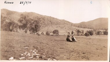
Black and white photograph of farmland, Kiewa, 25/8/38, circa 1938
This photograph was taken in August, 1938 at the time of road making in the area and some eight years prior to the establishment of Mt. Beauty township. The area was still being used for grazing, and the land was eventually acquired from the local land owners by the State Electricity Commission. The construction of the road, from Tawonga to the High Plains, was commenced in April of this year. This allowed men and heavy equipment to be transported to the work sites for the construction of the Kiewa Hydro Electric Scheme. An important photograph as it shows the upper Kiewa Valley as it was before the establishment of the town of Mt. Beauty. The land had been cleared of natural growth and has been used for grazing cattle. By 1946 housing construction had commenced for the new town of Mt. Beauty and by 1948 street construction in the southern part of the town was completed as far as Hill Street.A black and white photograph taken in the upper Kiewa Valley showing farmland with a group of three unidentified people sitting on the grass.Handwritten in black ink is the inscription 'Kiewa 25/8/1938'. In the right corner of the photograph has been stamped the number 6. On the back in a circle, some 14mm across, are the words 'Kodak Print'. The word Velox is also printed on the back.kiewa, mt. beauty, construction, grazing, secv -
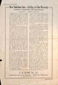 Melbourne Tram Museum
Pamphlet - Real estate sale, T M Burke, "New Suburban line - Darling to Glen Waverley", July 1926
Pamphlet advising potential land purchasers of the recommendation to extend the railway line from Darling to Glen Waverley, extracted from The Age 26/6/1926. Advises that the land and losses would be paid for by the residents through their rates. Gives costs of the proposed new line. Has a plan showing the estates for sale along the line, the Ashburton line (later extended to Alamein) and Burwood Road. Published by T M Burke Pty Ltd. Demonstrates the style of land sale pamphlet including the proposed availability of train services to prospective purchasers.Pamphlet - single quarto sheet with map on rear - printed.sale of land, real estate, railways, glen waverley, suburban railways