Showing 1534 items
matching aerial photographs
-
 Eltham District Historical Society Inc
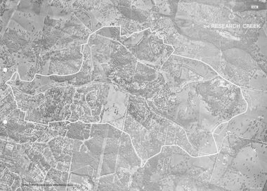
Work on paper (Sub-Item) - Photograph, Research Creek
... Black and White aerial photograph of Research witht... melbourne Black and White aerial photograph of Research witht ...Black and White aerial photograph of Research witht the Research Creek and Main Road highlighted.eltham, research, aerial view, research creek -
 Stawell Historical Society Inc
Photograph, Stawell Industrial Area Aerial View with the Woollen Mills, Stawell Timber Industry & Pleasant Creek Hospital
... Aerial Photograph Woollen Mills, Stawell Timber Industry...Aerial Photograph Woollen Mills, Stawell Timber Industry ...Aerial Photograph Woollen Mills, Stawell Timber Industry, Pleasant Creek Hospital, Oval,.industry -
 Orbost & District Historical Society
aerial photograph, 1970's
... aerial photograph...A large black and white aerial photograph of Orbost Railway... orbost A large black and white aerial photograph of Orbost ...This photograph was taken prior to the closure of the Orbost -Bairnsdale freight line in 1987.The Orbost-Bairnsdale railway initially played a crucial role in developing agricultural industries in Gippsland as well as tourism. It opened in 1916 and operated until 1987, principally carrying timber and farming produce. In the early days of the railway's operation dedicated passenger trains ran but these ceased by the 1930s. The line was completely closed to freightage in 1987.The track infrastructure was dismantled in 1994 and has been redeveloped as the East Gippsland Rail Trail.A large black and white aerial photograph of Orbost Railway Station in the foreground and the Orbost township in the background. It has been pasted onto a piece of Masonite. railway photography orbost, railway photography orbost -
 Glenelg Shire Council Cultural Collection
Photograph - Photograph - aerial view of Portland, c. 1954
... Photograph - aerial view of Portland...Black and white aerial photograph of coastline around... border Black and white aerial photograph of coastline around ...Black and white aerial photograph of coastline around Portland. Black border, scale all sides, 5 rows of 3 't' at regular intervals.Front: '607 -105' -- handwritten, white, lower border 'RUN 5' 'PORTLAND', printed, white, lower borderaerial photography, central portland, portland harbour -
Glenelg Shire Council Cultural Collection
Photograph - Photograph - aerial view of Portland, c. 1954
... Photograph - aerial view of Portland...Black and white aerial photograph of coastline around...'. printed, white lower border. Black and white aerial photograph ...Black and white aerial photograph of coastline around Portland. Black border, scale all sides, 5 rows of 3 't' at regular intervalsFront: '607 -101' - handwritten, white, lower border. 'Run 5' 'PORTLAND'. printed, white lower border.aerial photography, central portland, portland harbour, south west coastline -
Glenelg Shire Council Cultural Collection
Photograph - Photograph - aerial view of Portland, c. 1954
... Photograph - aerial view of Portland...Black and white aerial photograph of coastline around...', printed, white, lower border Black and white aerial photograph ...Black and white aerial photograph of coastline around Portland. Black border, scale all sides, 5 rows of 3 't' at regular intervals.Front: '607 -104' - handwritten, white, lower border 'RUN 5' 'PORTLAND', printed, white, lower borderaerial photography, central portland, portland harbour, south west coastline -
Glenelg Shire Council Cultural Collection
Photograph - Photograph - aerial view of Portland, c. 1954
... Photograph - aerial view of Portland...Black and white aerial photograph of coastline around...', printed, white, lower border Black and white aerial photograph ...Black and white aerial photograph of coastline around Portland. Black border, scale all sides, 5 rows of 3 't' at regular intervals.Front: '607 -103' -- handwritten, white, lower border 'RUN 5' 'PORTLAND', printed, white, lower borderaerial photography, central portland, portland harbour, south west coastline -
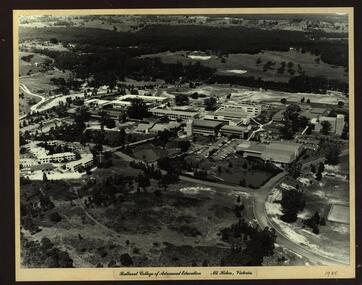
 Federation University Historical Collection
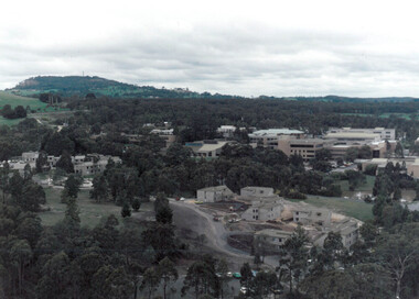
Photograph - Colour, Ballarat College of Advanced Education, Mount Helen
... Colour aerial photographs showing the Mount Helen Campus... student residences Ballarat streetscape Colour aerial photographs ...Colour aerial photographs showing the Mount Helen Campus at Ballarat College of Advanced Education, now Federation University Australia Mount Helen Campus.ballarat college of advanced education, mount helen, mount buninyong, student residences, ballarat streetscape -
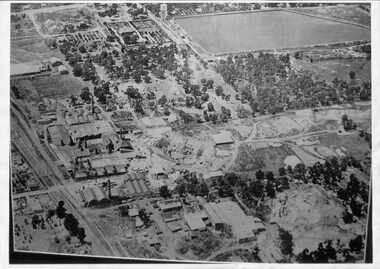
 Federation University Historical Collection
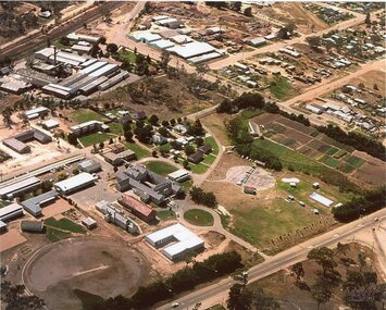
Photograph - Photograph - Black and White, Ballarat College of Advanced Education, Mt Helen - 1985, 1985
... is then mounted onto black board. Aerial photograph of Ballarat College... is then mounted onto black board. Aerial photograph of Ballarat College ...Photograph of the early years of the Ballarat College of Advanced Education at Mt Helen. On the left is the first stage of the student accommodation with a bridge connecting it to the campus. The car park located near the lakes is next to the Physical Education building. This is before the swimming pool has been added. The building with large white external structure is the E.J.Barker Library before the top floor has been built. This floor is where the Geoffrey Blainey Research Centre is housed.Photograph mounted on heavy white card which is then mounted onto black board. Aerial photograph of Ballarat College of Advanced Education at Mt Helen.ballarat college of advanced education, student accomodation, physical education, swimming pool, e j barker library, geoffrey blainey research centre, student residences -
Port Melbourne Historical & Preservation Society
Photograph - Aerial view of Port Melbourne piers and foreshore, Jack GOULD
... Black and white aerial photograph showing the Port... and white aerial photograph showing the Port Melbourne foreshore ...From a box of photographs in Nancy U'REN's papers used during research for her thesis, The Early Growth and Development of Sandridge (1976) and/or her book with Noel TURNBULL, A History of Port Melbourne (1983). Jack GOULD probably created this from an earlier photograph.Black and white aerial photograph showing the Port Melbourne foreshore and the piers from Princes Pier to Lagoon Pier and beyond. C. 1922-23.piers and wharves - princes pier, piers and wharves - town pier, piers and wharves - lagoon pier, foreshore, piers and wharves - railway pier, nancy u'ren nee morris -
 National Vietnam Veterans Museum (NVVM)
Photograph, Vung Tau from the air
... Colour Photograph in a black frame. Aerial Photograph... Presentation Plaque Colour Photograph in a black frame. Aerial ...Colour Photograph in a black frame. Aerial Photograph of Vung Tau taken from the door of a helicopter. The helicopter door gun can be seen in the foreground.Presentation Plaquephotograph, vung tau -
 Whitehorse Historical Society Inc.
Photograph - Aerial Photograph, Mitcham Reservoir
... Aerial Photograph...Black and white aerial photograph of Mitcham showing...) in the foreground. Mitcham Reservoir Photograph Aerial Photograph ...Most of the area is now Thornton Crescent, Mitcham, a factory area. When erecting the present 'buildings', which are all single level, certain strategies were employed to ensure safety.Black and white aerial photograph of Mitcham showing the reservoir, Australian Tesselated Tiles with the clay pit at the rear, and Monarch Tiles (1914-16) in the foreground.mitcham reservoir, australian tesselated tile co. pty ltd, monarch terra cotta pty ltd -
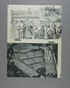 Tennis Australia
Page from Magazine, 1957
... aerial photograph, of the Newport Casino, the first home..., an 1880 lithograph, and a 1957 aerial photograph, of the Newport ...A page featuring two images, an 1880 lithograph, and a 1957 aerial photograph, of the Newport Casino, the first home of the U.S. Open. Materials: Paper, Inktennis -
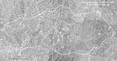 Eltham District Historical Society Inc
Work on paper (Sub-Item) - Photograph, St Helena East, St Helena West and Eltham West drains, ca 1980
... black and white aerial photograph with boundary and drains... melbourne black and white aerial photograph with boundary and drains ...black and white aerial photograph with boundary and drains marked over three page fold out eltham, st helena, drains, aerial view -
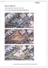 Greensborough Historical Society
Article and Photograph, Watermarc 2009-2016, 2016_
... Aerial photographs of the Greensborough Pool site being... Plenty Lower Plenty melbourne Aerial photographs ...Aerial photographs of the Greensborough Pool site being redeveloped into WaterMarc (2009-2016). Images from nearmap.com.auThis text and photographs were copied from a Facebook site. Members are people who lived in the Greensborough area and share their reminiscences of the area with others. The site is administered by a GHS member but is not officially affiliated with the Society. Any information is the opinion of the contributor. Photographs and text sourced from social media.greensborough pool, watermarc -
Creswick Campus Historical Collection - University of Melbourne
Equipment, Sketchmaster
... Aerial photograph converter. Complete instrument... Building 719 Creswick goldfields Aerial photograph converter ...Aerial photograph converter. Complete instrument with instructions, a number of parts in a large grey wooden custom boxEquipment -
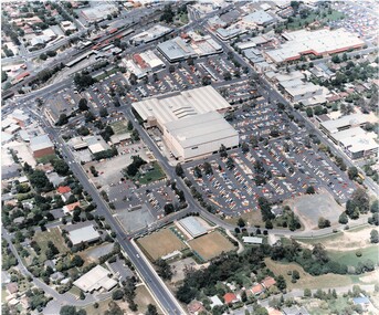 Ringwood and District Historical Society
Photograph, Aerial Views of Eastland Precinct, Ringwood, Victoria - circa 1990
... Two colour aerial photographs overlooking commercial area.... Two colour aerial photographs overlooking commercial area ...Two colour aerial photographs overlooking commercial area of Ringwood centred on Eastland shopping precinct (prior to Stage 2 extension proposed to commence in 1992).Aerial Photography by R.J. Moss. -
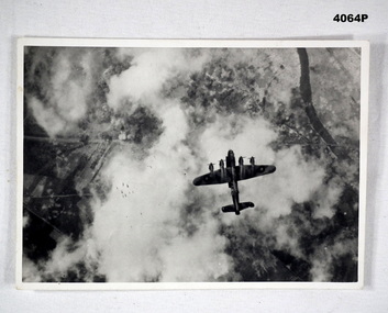 Bendigo Military Museum
Photograph, c.WWII
... Photo, black & white, white border, aerial photograph... goldfields Photograph of a Lancaster bomber on a bombing mission ...Photograph of a Lancaster bomber on a bombing mission. Bombs released by the aircraft are visible. Part of Frederick Gardner Davey DFC No.410533 RAAF collection. See Cat. No. 3536P for his service record.Photo, black & white, white border, aerial photograph of an aircraft dropping a stick of bombs over a target. Ground target partially visible through clouds.On back, handwritten in blue ink: "I.M. Davey Pres. C.W.A. Strathdale. 'Stick of bombs going down'".bombing run, photography, ww2 -
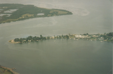
Phillip Island and District Historical Society Inc.
Photograph
... Black & White Aerial Photograph showing the two bridges... Aerial Photograph showing the two bridges between Newhaven ...Photograph from The Herald and donated by Jack MorrisonBlack & White Aerial Photograph showing the two bridges between Newhaven and San Remo, the old and the new. (Same photo as 100-09, reduced in size)local history, photography, photographs, slides, film civil engineering, bridges, history of the phillip island bridge, black & white photograph, phillip island bridges -
Glenelg Shire Council Cultural Collection
Card - Christmas Card, n.d
... . Anderson. Cream card, gold print, aerial photograph of the Port.... Cream card, gold print, aerial photograph of the Port ...Christmas card from the Port of Portland Authority to K.S. Anderson. Cream card, gold print, aerial photograph of the Port of Portland on front cover. Unsigned.greetings card, christmas, k s anderson, port of portland authority archives -
Glenelg Shire Council Cultural Collection
Photograph - Photograph - Thomas Borthwick and Sons, n.d
... Black and white aerial photograph of Thomas Borthwick... Authority Archives Port of Portland Black and white aerial ...Port of Portland Authority Archivesport of portland -
Glenelg Shire Council Cultural Collection
Photograph - Photograph - Aerial photograph of coastline around Portland Victoria, c. 1954
... Photograph - Aerial photograph of coastline around Portland...Black and white aerial photograph of coastline around..., white border Black and white aerial photograph of coastline ...Black and white aerial photograph of coastline around Portland. Black border, bottom edge, section of larger photo, approximately 50%, only land visible.Front: 'PORTLA' -printed, white border -
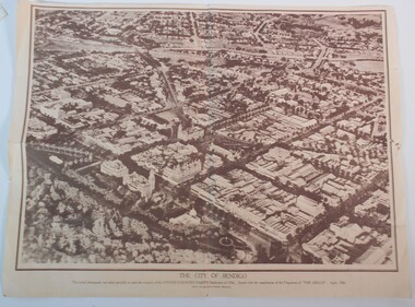 Bendigo Historical Society Inc.
Document - BAGGALEY COLLECTION: LARGE AERIAL PHOTOGRAPH POSTER OF BENDIGO APRIL 1936
... BAGGALEY COLLECTION: LARGE AERIAL PHOTOGRAPH POSTER OF...Sepia print of an aerial photograph of the centre...: LARGE AERIAL PHOTOGRAPH POSTER OF BENDIGO APRIL 1936 ...Sepia print of an aerial photograph of the centre of Bendigo taken specially for the occasion of the United Country Party conference of 1936 Issued with the compliments of 'the Argus' April 1936Wilson and Mackinnon Printers, Melbourne -
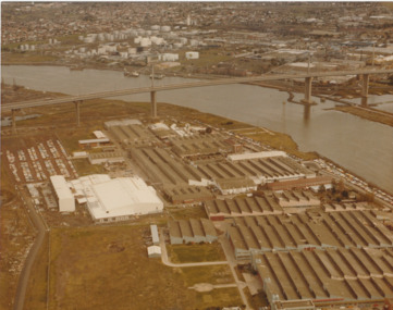 Port Melbourne Historical & Preservation Society
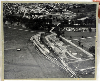
Photograph - Aerial view of West Gate Bridge under construction, 1970 - 1979
... Colour aerial photograph of West Gate Bridge completed... Colour aerial photograph of West Gate Bridge completed. Aircraft ...Colour aerial photograph of West Gate Bridge completed. Aircraft factory and other industry in foreground. Williamstown and fuel storage tanks in background (Coode Island)"Gov't A/C Factories Photographic Section Neg No N2841/3" stamped on backtransport, engineering, engineering - bridges, fishermans bend, industry, west gate bridge, rotten row, williamstown, yarra river -
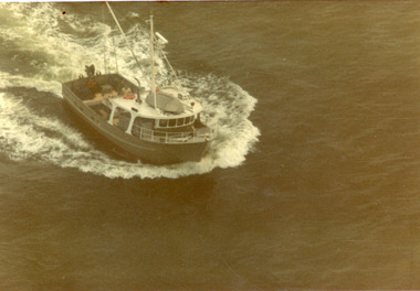 Lakes Entrance Historical Society
Photograph - Tarpeena, Hammarstrom Ian, 1986 c
... Colour aerial photograph of the fishing boat Tarpeena...Ships and Shipping Fishing Industry Ocean Colour aerial ...Colour aerial photograph of the fishing boat Tarpeena in Bass Strait, taken from Colin Campbells aircraft, fish spotting from Lakes Entrance, Victoria.ships and shipping, fishing industry, ocean -
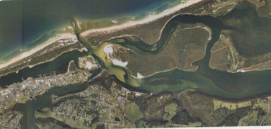 Lakes Entrance Historical Society
Photograph - Lakes Entrance, Gippsland Ports, 2006 c
... Aerial Photograph...Colour aerial photograph showing view of entrance...Aerial Photograph Historic Site Dredging Waterways Lakes ...Colour aerial photograph showing view of entrance to Gippsland Lakes from Bass Strait Reeves Channel Rigby Island and township of Lakes Entrance Victoriaaerial photograph, historic site, dredging, waterways, lakes entrance -
 Lakes Entrance Historical Society
Photograph - Metung, 1995 c
... Aerial Photograph...Colour aerial photograph of Shaving Point Gippsland Lakes...Aerial Photograph Waterways Topography Metung Colour aerial ...Colour aerial photograph of Shaving Point Gippsland Lakes with Mosquito Point bottom left hand corner Boole Poole on opposite shore Metung Victoriaaerial photograph, waterways, topography, metung -
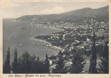 Phillip Island and District Historical Society Inc.
Photograph, 1950
... photographs aerial view - coastal view - san remo europe black & white ...Personal communication from Europe to relative (Aunt Elsie) in San Remo dated 17/06/1951Aerial view of San Remo coastline with row of various Pine Trees across foreground. Hills in background. Pier at top left. Shows town area of San Remo in Italy, Europe.San Remo - Riviera Dei Fiori - Panoramaphotography, photographs, aerial view - coastal view - san remo europe, black & white photograph, comparison views san remo, aerial -
Glenelg Shire Council Cultural Collection
Photograph - Photograph - aerial view of Portland, c. 1954
... Photograph - aerial view of Portland...Black and white aerial photograph of coastline around..., white, border Black and white aerial photograph of coastline ...Black and white aerial photograph of coastline around Portland. Black border, scale all sides, 5 rows of 3 't' at regular intervals. All oceanFront: '784 - 156- handwritten, white, border 'RUN 7 A PORTLAND', printed, white, borderaerial photography, central portland, portland harbour, south west coastline -
Glenelg Shire Council Cultural Collection
Photograph, Photograph Reclamation and Canal Work, 1959
... Black and white aerial photograph showing land reclamation.... Black and white aerial photograph showing land reclamation ...Port of Portland Authority ArchivesFront: General view: Aerial view West showing wharf and canal areas. November 1959 - typed.port of portland