Showing 812 items matching " construction site"
-
 Lorne Historical Society
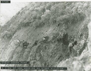
Photograph, Men working on steep hillside Great Ocean Road
... Photograph of men working on the steep hill site during... working on the steep hill site during the construction ...Photograph of men working on the steep hill site during the construction of the G.O.R.g.o.r. workmen -
 Greensborough Historical Society
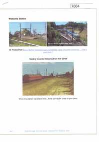
Article and Photograph, Watsonia station, 2016_
Photographs of the Watsonia station and surrounding train line during construction of the lowered train line - late 1970s.This text and photographs were copied from a Facebook site. Members are people who lived in the Greensborough area and share their reminiscences of the area with others. The site is administered by a GHS member but is not officially affiliated with the Society. Any information is the opinion of the contributor. Photographs and text sourced from social media.watsonia railway station, hurstbridge train line -
 Glenelg Shire Council Cultural Collection
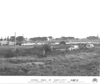
Photograph - Photograph - Portland Harbour Trust - Works area at Sand-spit, 6.8.52, 1952
... ' SITE & STORES BUILDING UNDER CONSTRUCTION (lower centre) Back... AT SAND-SPIT. 6/8/52/ SHOWING WORKSHOPS' SITE & STORES BUILDING ...Port of Portland Authority archivesFront: WORKS AREA AT SAND-SPIT. 6/8/52/ SHOWING WORKSHOPS' SITE & STORES BUILDING UNDER CONSTRUCTION (lower centre) Back: P.H.T./ Print No. 3/3 Neg. No // Date taken 6-8-52./ SUBJECT./ % (Ink stamp with blue pen and pencil additions, centre)port of portland archives -
 Greensborough Historical Society
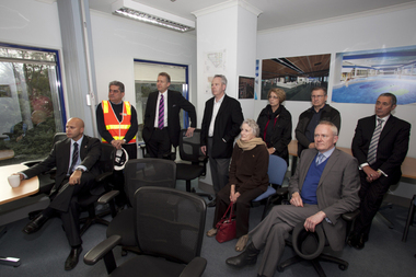
Photograph - Digital image, Watermarc under construction: Visitor group seated in site office, 18/05/2012
Visitors group seated in site office. The redevelopment of the Greensborough Pool into the Watermarc aquatic centre is documented in this collection of photographs from the collection of Rosie Bray. These photographs taken on a ‘Community Consultative Committee’ walkthrough prior to completion of Watermarc, May 18 2012.Digital copy of colour photograph.watermarc, greensborough swimming pool, rosalie bray -
 Greensborough Historical Society
Photograph - Digital image, Trevor Partington's Church Street property 1973, 1973_
Two photographs of a Church Street Greensborough property owned by Trevor Partington. This property was acquired during the construction of Greensborough Plaza and is now the site of the Church Street car park. (Copied 31/10/2011)The Partington family are Greensborough pioneers.Digital copy of 2 colour photographs.church street, trevor partington -
![Photograph - Digital image, Kelly Garden Supplies [Greensborough], 02/05/2013](/media/collectors/4f729f5697f83e03086015b8/items/5729bced2162f108e8de6b52/item-media/5729bd212162f108e8de74aa/item-fit-380x285.jpg) Greensborough Historical Society
Greensborough Historical SocietyPhotograph - Digital image, Kelly Garden Supplies [Greensborough], 02/05/2013
This photograph of the former site of Kelly Garden Supplies was taken in 2013 to show changes over 40 years, based on Ron Reynold’s sketches in the 1973 publication “Greensborough and Greenhills” published by Cypress Books. The site is now part of the Civic roundabout at the top of the Greensborough By-pass. Civic Drive was associated with the building of Diamond Valley Council Offices opened by Governor Rohan Delacombe on 26/2/1972. Previously it was known as Kelly's Track which wound its way around to a house that overlooked the aqueduct bridge. Kelly's Sandpit (quarry) was the local go to place to obtain road, driveway fill and red sand for local construction. For 80 years previous Kelly's quarry supplied sand to the greater Melbourne area for the surfacing of school grounds, parks etc. Digital copy of colour photograph.greensborough and greenhills, civic drive greensborough, kelly garden supplies, ron reynolds -
 Greensborough Historical Society
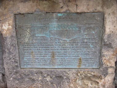
Photograph - Digital image, Dennis Ward, Bridge Plaque - Pioneer Park Greensborough, 27/03/2010
Plaque at Pioneer Reserve Greensborough: "Shire of Diamond Valley. The bluestones used in the construction of this viewing platform and in the carpark entry structure and retaining wall are from the northern arch of Greensborough's first Plenty River Bridge built in the 1860s adjacent to this site. The centre span of the original bridge was removed in 1865 when the western half of the existing bridge was constructed leaving the northern and southern stone arches. The southern arch was retained until floods in 1874 necessitated its removal. The picnic shelter in this reserve was constructed using stone from this abutment. The northern arch was removed in 1983 when widening of the existing bridge commenced."Digital copy of colour photograph.plenty river, pioneer reserve greensborough -
 Glenelg Shire Council Cultural Collection
Slide - Slide - Construction Portland/Cashmore Airport, c. 1980
... . Roadmaking equpiment and two workmen on runway site. Slide Slide ...Coloured slide. Roadmaking equpiment and two workmen on runway site. -
Glenelg Shire Council Cultural Collection
Slide - Slide - Cashmore Airport, Portland, 1980s
Coloured slide. Side view of runway site. Several earth moving/vehicles/trucks in distance.portland airport, cashmore airport, portland development, construction -
Glenelg Shire Council Cultural Collection
Slide - Slide - Construction Portland/Cashmore Airport, c. 1980
... making equipment working on runway site. Slide Slide ...Coloured slide. Road making equipment working on runway site. -
Glenelg Shire Council Cultural Collection
Slide - Slide - Cashmore Airport, Portland, 1980s
Coloured slide. Road making equipment on runway site. Large cloud of dust.portland airport, cashmore airport, construction, engineering, runway, air travel -
Glenelg Shire Council Cultural Collection
Slide - Slide - Construction of Portland / Cashmore Airport, 1980s
... making equipment and 2 workmen on runway site. Slide Slide ...Coloured slide. Road making equipment and 2 workmen on runway site. -
Glenelg Shire Council Cultural Collection
Slide - Slide - Construction of Portland / Cashmore Airport, Victoria, 1980s
Coloured slide. Runway work site. Grader and excavator on left. Pale with black pipe wrapped around it on right. 2 workmen behind grader. -
Glenelg Shire Council Cultural Collection
Photograph, Silo construction, n.d
... on site. Silo construction Photograph Photograph ...Port of Portland Authority ArchivesBack: Top left corner June 9th - pencil -
Glenelg Shire Council Cultural Collection
Photograph - Photograph - Alcoa, Portland, 07/01/1981
Port of Portland Authority Archievesport of portland archives, alcoa, construction -
Glenelg Shire Council Cultural Collection
Photograph - Photograph - contact prints showing silo conveyor construction, Portland, 1964
Port of Portland Authority ArchivesFront: 87. 23-9-64 88. 23-9-64 89. 23-9-64 90. 23-9-64 91. 23-9-64 92. 23-9-64 (Beneath each print, in white.) Back: 87 pencilport of portland archives, grain silos, k s anderson wharf -
Glenelg Shire Council Cultural Collection
Slide - Slide - Cashmore Airport, Portland, 1980s
Coloured slide. Side view of runway site. Several earth moving/vehicles/trucks in distance.portland airport, cashmore airport, air travel, construction, engineering -
Glenelg Shire Council Cultural Collection
Slide - Slide - Cashmore Airport, Portland, 1980s
... Airport construction engineering Coloured slide. Site ...Coloured slide. Site of an airport before any construction. Green, flat large area of land, rising up slightly in background.portland airport, cashmore airport, construction, engineering -
Glenelg Shire Council Cultural Collection
Slide - Slide - Construction Portland/Cashmore Airport, c. 1980
Coloured slide. Run-way site. Several road-making vehicles. Clouds of dust. -
Glenelg Shire Council Cultural Collection
Slide - Slide - Construction Portland/Cashmore Airport, c. 1980
Coloured slide. Earth moving equipment on runway site. Large areas of water. -
Glenelg Shire Council Cultural Collection
Slide - Slide - Construction Portland/Cashmore Airport, c. 1980
... operating earth moving equipment on muddy area of work site. Slide ...Coloured slide. Man operating earth moving equipment on muddy area of work site. -
Glenelg Shire Council Cultural Collection
Slide - Slide - Construction Portland/ Cashmore Airport, c. 1980
Coloured slide. Runway work site. Frader and escavator on left. Pole with black pipe wrapped around it, on right. Two workneb behind grader. -
Glenelg Shire Council Cultural Collection
Slide - Slide - Cashmore Airport construction, Portland, 1980s
Colored slide. View across paddocks from elevated position. Site for airport.portland airport construction, portland development -
 Eltham District Historical Society Inc
Photograph, John Collins, Shillinglaw Cottage on its original site, 17 Oct. 1963
Shilinglaw Cottage in its original location on Main Road Eltham with the “Shillllinglaw trees”. This image was taken shortly before its relocation. Believed to be have been taken by John Collins, 17 Oct 1963 as per other images held by the State Library of Victoria Author / Creator: John T Collins 1907-2001 , photographer. J.T. Collins Collection, La Trobe Picture Collection, State Library of Victoria. Shillinglaw Cottage is significant to Eltham’s local history. It is one of the earliest known buildings still in existence. Records suggest that the cottage was built circa 1859 by a man named Cochrane, believed to be Thomas Cochrane, in conjunction with George Stebbings though it is not known what Stebbings’s contribution was. It is made from hand made bricks laid in a Flemish bond pattern. In the 1960s it was marked for demolition to make way for the construction of new council buildings but a community campaign saved the cottage and it was re-located. It is believed Stebbings owned the cottage between 1874 and 1888. According to Margaret Ball’s (2017) book Shillinglaw Family of Eltham 1660-2007, Thomas Cochrane and family lived there from 1867 to 1874 however this is contrary to the records of assessable rates levied by the Eltham District Road Board, established in 1858, which shows Cochrane was the owner occupier (in Little Eltham) of approximately 25 acres of cultivated land and 25 acres of pastureland upon which a hut was sited in 1860. It is suspected that George Stebbings may have acquired the property from Cochrane in 1874 as it is noted that he had a tenant for a period, James Rossiter, who was the editor for the Evelyn Observer in Kangaroo Ground in 1874 (LATE SHIRE OFFICE AT KANGAROO GROUND (1934, February 16). Advertiser (Hurstbridge, Vic. : 1922 - 1939), p. 5. Retrieved February 25, 2022, from http://nla.gov.au/nla.news-article56743657). In 1881 Phillip Shillinglaw became the ratepayer for the cottage though Stebbings retained ownership until 1888 at which time it was transferred to Shillinglaw. This photo forms part of a collection of photographs gathered by the Shire of Eltham for their centenary project book, "Pioneers and Painters: 100 years of the Shire of Eltham" by Alan Marshall (1971). The collection of over 500 images is held in partnership between Eltham District Historical Society and Yarra Plenty Regional Library (Eltham Library) and is now formally known as 'The Shire of Eltham Pioneers Photograph Collection.' It is significant in being the first community sourced collection representing the places and people of the Shire's first one hundred years.Digital image 4 x 5 inch B&W Negsepp, shire of eltham pioneers photograph collection, eltham, shillinglaw cottage, shillinglaw trees, significant tree -
 Eltham District Historical Society Inc
Negative - Photograph, Shillinglaw Cottage, 17 Oct. 1963
Shilinglaw Cottage in its original location on Main Road Eltham with the three Mediterranean Cypress trees (“Shillllinglaw trees”) in the garden. Note a fourth pine to the right. This image was taken shortly before its relocation. Believed to be have been taken by John Collins, 17 Oct 1963 as per other images held by the State Library of Victoria Author / Creator: John T Collins 1907-2001 , photographer. J.T. Collins Collection, La Trobe Picture Collection, State Library of Victoria. Shillinglaw Cottage is significant to Eltham’s local history. It is one of the earliest known buildings still in existence. Records suggest that the cottage was built circa 1859 by a man named Cochrane, believed to be Thomas Cochrane, in conjunction with George Stebbings though it is not known what Stebbings’s contribution was. It is made from hand made bricks laid in a Flemish bond pattern. In the 1960s it was marked for demolition to make way for the construction of new council buildings but a community campaign saved the cottage and it was re-located. It is believed Stebbings owned the cottage between 1874 and 1888. According to Margaret Ball’s (2017) book Shillinglaw Family of Eltham 1660-2007, Thomas Cochrane and family lived there from 1867 to 1874 however this is contrary to the records of assessable rates levied by the Eltham District Road Board, established in 1858, which shows Cochrane was the owner occupier (in Little Eltham) of approximately 25 acres of cultivated land and 25 acres of pastureland upon which a hut was sited in 1860. It is suspected that George Stebbings may have acquired the property from Cochrane in 1874 as it is noted that he had a tenant for a period, James Rossiter, who was the editor for the Evelyn Observer in Kangaroo Ground in 1874 (LATE SHIRE OFFICE AT KANGAROO GROUND (1934, February 16). Advertiser (Hurstbridge, Vic. : 1922 - 1939), p. 5. Retrieved February 25, 2022, from http://nla.gov.au/nla.news-article56743657). In 1881 Phillip Shillinglaw became the ratepayer for the cottage though Stebbings retained ownership until 1888 at which time it was transferred to Shillinglaw.Shillinglaw Cottage is itself historically, aesthetically and socially significant to the Shire of Nillumbik and is registered on the Victorian Heritage Database. This photo forms part of a collection of photographs gathered by the Shire of Eltham for their centenary project book, "Pioneers and Painters: 100 years of the Shire of Eltham" by Alan Marshall (1971). The collection of over 500 images is held in partnership between Eltham District Historical Society and Yarra Plenty Regional Library (Eltham Library) and is now formally known as 'The Shire of Eltham Pioneers Photograph Collection.' It is significant in being the first community sourced collection representing the places and people of the Shire's first one hundred years.Digital image 4 x 5 inch B&W Negsepp, shire of eltham pioneers photograph collection, eltham, shillinglaw cottage, significant tree -
 Eltham District Historical Society Inc
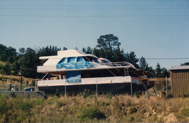
Photograph, Peter Bassett-Smith, Research Industrial Centre, Main Road, April 1988, 1988
... Industrial Centre, Main Road, April 1988 including site with boats..., April 1988 including site with boats under construction ...Two colour photographs showing two views of Research Industrial Centre, Main Road, April 1988 including site with boats under construction.main road, research vic., industrial estate, boats -
 Kiewa Valley Historical Society
Photograph from Lake Guy, Bogong Village, Scene from shores of Lake Guy to Mountain range, 1930s to 1950s
In 1940 Field Headquarters for the Kiewa Scheme were established at Bogong with office, workshop facilities and accommodation for workmen, staff and some families constructed. (There had been a 'tent camp' on this site in 1939 but was destroyed by bushfires) Construction of accommodation continued until 1947. A total of 40 houses plus a hostel for single staff, post office, police station, medical centre and primary school all with water and sewerage and electricity supply. The staff hostel was known as Kiewa House and is now occupied by the Education Department. Lake Guy was named after Mr. L.T. Guy who was the Resident Engineer in charge of construction work and associated activities on the Kiewa area. He held this position from 1939 to November 1946 when he was transferred to Head Office.The Bogong Township was developed firstly as an accommodation centre (base camp) for construction workers employed under the Kiewa Hydroelectric Scheme. Due to the influx of European workers into the Township the beautification of the immediate surrounds(gardens etc.) had a distinct European flavour. This environment has been very beneficial for tourism in later years. Strict environmental control has not allowed for any extensive redevelopment in tourist accommodation and basically restricted it to the accommodation initially built for the construction workers. Activities such a bike riding, snow skiing, restricted horse riding and bush walking on the Alpine plains and mountains are now a viable part of the Kiewa Valley Tourist Industry. The lake is one of the many water storage storage reservoirs used to supply the power stations their main power to run the huge turbines generating the final product, electricityThis black and white photograph shot from the shores of Lake Guy toward the mountain range of the Victorian Alps details the early construction of the construction worker's accommodation of the Bogong Village. The paper is of 200gms and is not photographic paper and can be assumed to be a reproduction of an original photobogong village circa 1930 to 1950, kiewa hydro-electricity scheme, victorian alpine region mid 1900s -
 Kiewa Valley Historical Society
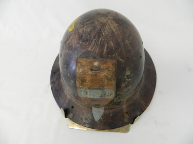
Helmet Safety, circa mid to late 1960's
This helmet worn by SEC Victoria workers in the Kiewa Hydro Electricity Scheme is a mandatory safety requirement by all personnel employed by government and statutory agencies who worked on or around "dangerous" apparatus or underground location sites. This type of pressed fibre helmet was later superseded by moulded plastic helmets. The start of the project (late 1940's) was not greatly covered by later introduced health and safety regulations. This has been demonstrated by photos of workmen outside using heavy machinery and other apparatus, see KVHS 0396, KVHS 0405 and KVHS 0392. However in the tunnels and underground safety helmets were mandatory, see KVHS 0403.This safety helmet was used by workers during construction of the generators and tunnels of the Kiewa Hydro Scheme was issued once only to each worker during his employment covering the 1940's to 1960's period. The attitude to health and safety during this period, can be summed up by this "initiation" ritual. When the helmet had been instrumental in saving a bad accident to a worker, that worker would be "invested" into the "Turtle Club". Although a safety helmet was only issued once to a worker this changed when modern moulded plastic helmets and greater Health and Safety requirements were introduced. Helmets now are replaced bi-annually.This safety helmet is made from pressed fibres with eyelets for airflow to the head. On the base of the helmet (before the rim) are 15 metal eyelets and three quarters up are six other eyelets (3 on each side). A thick leather strap is fastened by two rivettes to the main helmet. This strap has a metal bar rivetted on to affix a "safety" lamp, for underground work (Tunneling). There are two additional metal prongs and a metal bar to secure the lamp on the rim of the front of the helmet.sec vic kiewa hydro scheme, alternate energy supplies, alpine population growth -
 Kiewa Valley Historical Society
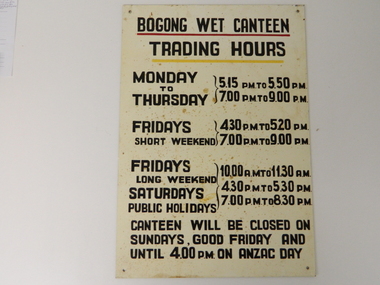
Sign Canteen Painted, Circa 1950
This sign is a part of the "human" factor required for remote and difficult, large impact (both labour and other resources) projects. It is one of the "human" factors which was clearly used in the big 1930's to the 1970's "landscape redevelopment" schemes which started in the early 1900's and is highly regarded as lifting the Australian psyche of only primary producers to an industrial level, equal to any in the world.This "Wet Canteen" sign was installed at the entrance of the Bogong "workers" village "provision's hut" detailing the operational times for the SEC Victorian staff and construction workers, involved in the building of the Kiewa Hydro Electricity Scheme to obtain alcoholic beverages. This facility lasted for over the extensive period (1938 to 1961) of the "Schemes" building phase. This large project was the forerunner when industrial legislation provided for the welfare of workers living in the Bogong Village. The provision of facilities such as a "wet canteen" was of the utmost importance not only to ensure that the long running project was both successful, production wise, but also that its employees were not only physically but also mentally healthy. This sign details that all aspects required for a fit and productive labour force were in place, in this remote and demanding work environment. The majority of heavy equipment and machinery used was either made in England or Europe. A section of the specialised workforce came from local and European expertise in dam construction and water management in alpine terrain. The majority of labour came from migrants and some specialists recruited from England and Europe. At this point in time, the quality of the machines used came from England, Europe and the USA and could not be matched from anywhere else in the developed world. With a specialised workforce came the responsibility of providing all the "comforts of home" including alcoholic beverages. On site accommodation for the workforce is still a requirement for some mining areas but high market returns have produced fly in/out labour.This anodised metal sign has been "block" stenciled on. Black lettering and numbers with the main headings underlined with a red and a yellow line(emphasising the headings)In black stenciled type "BOGONG WET CANTEEN" underneath this "TRADING HOURS" Below this "MONDAY TO THURSDAY 5.15 PM TO 5.50 PM, 7.00 PM TO 9.00 PM" "FRIDAYS SHORT WEEKEND 4.30 PM TO 5.20 PM 7.00 PM TO 9.00 PM" Below this "FRIDAYS LONG WEEKEND 10.00AM TO 11.30 AM" Below this "SATURDAYS PUBLIC HOLIDAYS 4.30 PM TO 5.30 PM 7.00 PM TO 8.30 PM" bELOW THIS "CANTEEN WILL BE CLOSED ON SUNDAYS, GOOD FRIDAY AND UNTIL 4.00 PM ON ANZAC DAY"saucer, plate, secv, state electricity commission of victoria, canteen, bogong mess hall, recreational amenities, socialisation of sec vic kiewa hydro scheme labour force -
 Kiewa Valley Historical Society
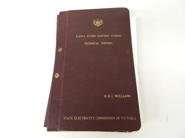
Book- History of SEC at Kiewa x2, Technical History of the Kiewa Hydro Scheme, circa 1960's
This book of planning and construction details covers the first detailed records the Kiewa Hydro Electricity Scheme of 1919 (ORIGINAL), 1958 (2nd Modified Plan) to the last general plan of 1961. It is an excellent overview of one of Australia's greatest construction projects (along with the Snowy River Hydro Scheme). This book highlights in detail the planning, programming and construction phases throughout the life of the construction from 1919 onwards until the 1960's. There were a few copies made using carbon paper and a type writer on foolscap paper.This book with its Parts A to D, photographs and plans/tables is very significant to the Kiewa Valley region as it details "the bones" of one of Australia's greatest construction projects that was undertaken by Governments that had the foresight and the will to undertake such a costly and environmentally imposing project for the benefit of their states and their country. This project was at a time when financial and security pressures where at a high and fluctuating level. This project was the major contributor to the expansion and diversity of non rural activities within the region. It was directly and indirectly the cause of better transportation avenues, tourism and the lifting of the regions natural facilities to sustain an ever increasing long term and short term population.This large hard (thick cover) book has both front and back sides fastened to the spine by two brass screw on pins. The book title, author/compiler and the commissioning organisation (STATE ELECTRICITY COMMISSION OF VICTORIA) together with the SEC Vic emblem are all embossed in gold script.The spine is also embossed with the title. The book contains 396 pages consisting of the 390 pages which are the duplicate(carbon copy) of the original type written pages and 6 pages of site plans. Sprinkled throughout the book are 36 original photographs of various stages of construction. There are also 17 sketches/plans scattered throughout and 22 tables.Title "KIEWA HYDRO ELECTRICITY SCHEME TECHNICAL HISTORY" author and compiler "H.H.C.WILLIAMS" below this "STATE ELECTRICITY COMMISSION OF VICTORIA"kiewa hydro electricity scheme, victorian state electricity commission, history, proposals, kiewa scheme's plans, book, h.h.c. williams