Showing 3433 items
matching distances
-
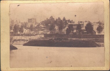
 Sunbury Family History and Heritage Society Inc.
Photograph, 2000
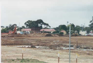
Excavation work to remove the grasslands and trees on the railway land on the west side of the Sunbury Station to make way for commercial development on that side of the line.A coloured photograph of excavation work in operation on land which has cyclone fencing around its perimeter. There are buildings in the middle distance beyond the work site.sunbury railway station -
 City of Kingston
Photograph - Black and white, c. 1920
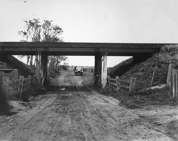
This image is part of a larger collection of images from the Public Transport Corporation displaying train stations and streetscapes in what is now the City of Kingston.While the focus of this image is the train line running overhead, the unsealed nature of the road speaks to the progression of suburban development during the 1920s.Black and white image of an unsealed underpass at Patterson Road, looking west. A car has stopped on the road in the distance and man is standing on the duckboard leaning into the car.Round white sticker on reverse with black printed text: 177 Handwritten in red ink: 60% Blue ink stamped on reverse: COPYRIGHT / Public Transport Corporation / For re-ordering photographs / Please quote negative No ADV 300 / Enquiries C/- PTC Photographic Unit / Telephone switchboard 619 111patterson road, railway, trains, cars, unsealed roads -
 Lakes Entrance Historical Society
Photograph, Tambo Shire, 1994 c
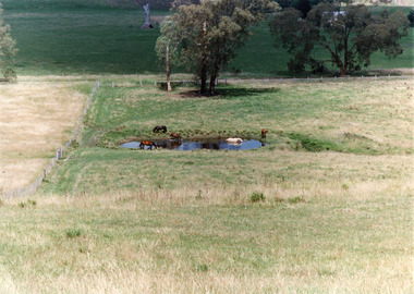
Also second identical copyColour photograph of a rural view near Buchan, shows five horses in and around a dam, farming building in distance glimpsed through trees. Bruthen Victoria topography, agriculture -
 Lakes Entrance Historical Society
Photograph - Bridges, Lakes Post Newspaper, 1999
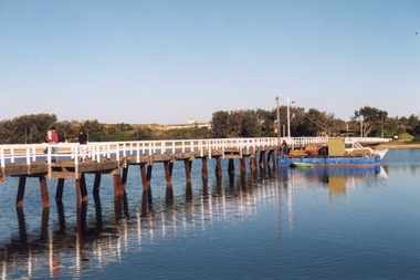
Image appeared in Lakes Post 19 May 1999|Also two other photographs similarColour photograph of repairs to the Cunninghame Arm Footbridge, shows Burys Slipway barge and workmen. Surf Lifesaving Clubroom on dunes in distance. Lakes Entrance Victoriabridges, waterways, topography -
 Southern Sherbrooke Historical Society Inc.
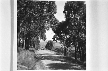
Looking west down road to Selby from Hermons Corner
A herd of cows belonging to Ryan can be seen coming up the road by the Breen farm, Menzies Creek. Trees line the road. Hills are visible in the distance. -
 Lakes Entrance Historical Society
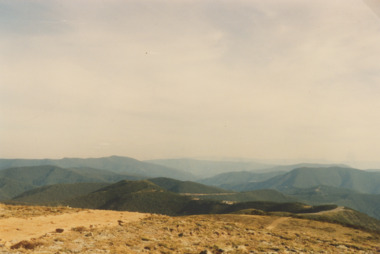
Photograph - Mt Hotham Victoria 1993, S Payne, 1/04/1993 12:00:00 AM
Colour photograph of scene from Mt Hotham showing Alps in distance and road to Omeo Victoria. Also a second colour photograph showing Mt Feathertop topography, roads and streets -
 Sunbury Family History and Heritage Society Inc.
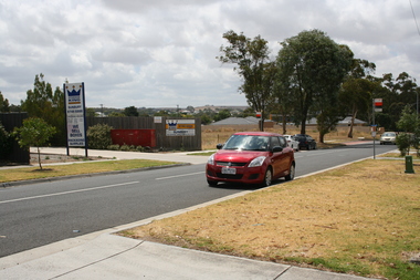
Photograph, Rosa McCall, Anderson Road, February 2014
The street in the photograph is Anderson Road in Sunbury, looking towards Darbyshire Road and the NW. The driveway with the hoarding on the LHS leads to the former Sunbury Storage Business. The photograph was taken in February 2014.A non-digital coloured photograph of a street with four cars parked along it and an advertising notice on the LHS of the image. Some housing and open areas are visible in the distance.anderson road, darbyshire road, sunbury -
 Lakes Entrance Historical Society
Postcard - Mary Lydia Laughton/Correspondence, 1905
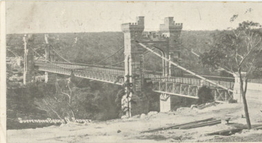
Posted 31.7.1905 from N. S. W. to Miss Laughton Kalimna Lakes Entrance Victoria Message says Please keep this card for my collection am getting a few more Yours GBlack and white postcard of suspension bridge North Sydney showing bushland in distance Sydney Australia.Plus second photo showing details of message on rear side.city, correspondence, hobbies, hotels -
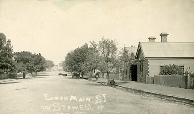 Stawell Historical Society Inc
Photograph, Lower Main Street Stawell. c1905 Looking East towards Railway Line. railway Hotel on Right
Lower Main Street. with Railway Hotel on Right. c1905.Postcard. Lower Main Street. Two Bullocks in the distance, A Carriage under a tree on the right side of Main Street, and a child on the footpath. Railway Hotel on Right.LOwer Main St.stawell transport streetscape -
 Bendigo Historical Society Inc.
Document - VICTORIA HILL - SKETCH MAP - VICTORIA HILL
Hand drawn sketch map of mines and depth. Some have distances between the shafts. Mines mentioned are: Great Central Victoria, Ballerstedt, Humboldt and Sterry's.document, gold, victoria hill, sketch map - victoria hill, great central victoria, ballerstedt, humboldt, sterry's -
 Bendigo Military Museum
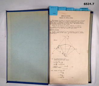
Booklet - Royal Australian Survey Corps - School of Military Survey Precis - Formula for Survey Calculations, School of Military Survey, Balcombe, Circa 1960s
This selection of Precis was produced by the Royal Australian Survey Corps, School of Military Survey, Balcombe, circa 1960s. The Precis are intended to instruct RASvy Surveyors employed on Engineer/ Field Survey Tasks on the calculations necessary for Surveying formula. The blue hard covered foolscap sized booklet held together with two Chicago screws contains 7 x precis listed below. .1 Setting out simple Curves .2 Earthworks .3 Calculation of area by double Latitude .4 Notes on Station Adjustment by Least Squares .5 Notes on Figure Adjustment by Least Squares .6 Technical Memo No1, Computation of Tellurometer Traverses using Plain Angles and Plain Distances by WO2 R Wilson RASvy (later Major) .7 Computing Traverses in Plane CoordinatesBlue Hard covered foolscap sized booklet held together with two Chicago screws. Booklet contains 7 x precis. .1 Setting out simple Curves .2 Earthworks .3 Calculation of area by double Latitude .4 Notes on Station Adjustment by Least Squares .5 Notes on Figure Adjustment by Least Squares .6 Technical Memo No1, Computation of Tellurometer Traverses using Plain Angles and Plain Distances by WO2 R Wilson (later Major) .7 Computing Traverses in Plane Coordinatesroyal australian survey corps, rasvy, fortuna, army survey regiment, army svy regt, asr, school of military survey -
 Bendigo Military Museum
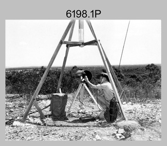
Photograph - Royal Australian Survey Corps Electronic Distance Measuring Equipment Demonstration, c1960s
This is a set of five photographs of CAPT James ‘Jim’ Leslie Stedman in the field demonstrating the setup of prisms used as electric distance measurement (EDM) receiver reflectors for tellurometer equipment and the sighting of a large surveyor’s light. This equipment was deployed in establishing mapping and geodetic control operations. The photos were most likely taken in the late 1950s or early 1960s. The tellurometers of this era were man-portable systems that improved geodetic survey efficiencies for rapid network extension and densification replacing triangulation with EDM and theodolite traverse sometimes using Bilby Towers to extend line lengths. Jim Stedman later reached the rank of Colonel, was Director of Military Survey from 1975 to 1978 and was appointed as Colonel Commandant (honorary appointment, Retd) of the Royal Australian Survey Corps from 1978 to 1983. Jim Stedman is demonstrating EDM equipment. See item 6180.16P, photos .14) to .16) for more information and photos of Jim Stedman’s EDM demonstration. This is a set of five photographs of a surveyor in the field demonstrating electric distance measurement (EDM) equipment. c1950s – 1960s. The photographs were printed on photographic paper and are part of the Army Survey Regiment’s Collection. The photographs were scanned at 300 dpi. .1) to .2) - Photo, black & white, c1960s, CAPT Jim Stedman demonstrating the sighting of a large surveyor’s light. .3) to .5) – Photo, black & white, c1960s, CAPT Jim Stedman demonstrating EDM prism equipment. .1P to .5P on back – CAPT Stedman EDM Eqpt.royal australian survey corps, rasvy, army survey regiment, army svy regt, fortuna, asr, surveying -
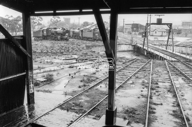 Eltham District Historical Society Inc
Photograph, George Coop, Railway turntable, Ararat Locomotive Shed, c.1971
Steam locomotives J-549 and K-163 in distance.Digital TIFF file Scan of 35mm Ilford FP3 black and white negative transparencygeorge coop collection, ararat locomotive shed, j-549, j-class steam locomotive (vulcan foundry), k-163, k-class steam locomotive (vr newport workshops) -
 Greensborough Historical Society
Photograph - Digital image, Marilyn Smith, Diamond Valley Learning Centre 1, 16/08/2015
Diamond Valley Learning Centre in the distance across oval.Digital copy of colour photographdvlc greensborough, partingtons flat -
 Greensborough Historical Society
Photograph - Digital image, Marilyn Smith, Diamond Valley Learning Centre 2, 16/08/2015
Diamond Valley Learning Centre in the distance across oval.Digital copy of colour photographdvlc greensborough, partingtons flat -
 Ringwood and District Historical Society
Photograph, Distance casting -Ringwood- Circa 1940's
Black and white photograph - postcard size"Written on back of photograph" Distance casting -Ringwood First time using 51 ft head,40yds Beening cast J.M.Gillies - Circa 1940's -
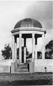 Stawell Historical Society Inc
Photograph, Pioneers’ Memorial on Big Hill -- 3 Photos
Three black and white photos of Pioneers Memorial Stawell. The larger of the 4 photos is a Post card and taken earlier than the other 3 photos as there is a plastic milk crate over the area where the direction indicator was later placed. This photo also has "Chapman photo Stawell" stamped on the print. Two of the smaller photos show the Pioneer Memorial at a distance with people standing between the memorial and a bus parked to the left of the photograph. One of these two photos has a white seat on the right side. The fourth photo has "Murray View No. 8 Pioneers' Memorial, Stawell Vic". printed on the photograph of the Pioneers' Memorial. Each of the these 3 smaller photos have the direction indicator under the dome.Three black and white photos of Pioneers Memorial Stawell. The larger of the 3 photos is a Post card taken earlier than the other 2 photos as there is a plastic milk crate over the area where the direction indicator was later placed. This photo also has "Chapman photo Stawell" stamped on the print. Two of the smaller photos show the Pioneers' Memorial at a distance with people standing between the memorial and a bus parked to the left in the photograph. One of these two photos has a white seat on the right side. Each of the 2 smaller photos have the direction indicator under the dome.Chapman Photo Stawell (right bottom corner). Post Card printed on the back and also a stamp "Stawell district - Pioneer's Memorial - written inside the stamp is "Every blade of grass that grows And mullock heap and tree, Speak of Old days, the Good days, And times that used to be"stawell -
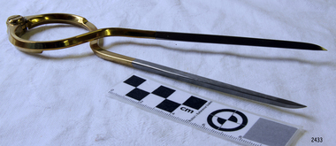 Flagstaff Hill Maritime Museum and Village
Functional object - Map Calipers/ Divider, Unknown
Compass, divider, and caliper are basically instruments that have two legs pivoted to each other at the top and are concerned with small-distance measurement or transfer. The compass and divider have straight legs; the caliper has curved legs. Dividers and Calipers were known to both the Greeks and Romans, though the caliper was uncommon. A divider with a circular sector, or wing, connecting the two legs was sketched in 1245, its modern counterpart is the wing divider with a thumbscrew clamp and screw for fine adjustment. Or the marine dividers used to measure the distance a vessel has travelled by transferring the vessels distance from a map with the divider and transferring that measurement to a marine ruler to mathematical calculate the distance.Item is believed to be a replica/ copy of a 19th century map calipers used in marine navigation to determine distance travelled. Item was probably purchased between 1972-1975 to add to the marine displays at Flagstaff Hill.Stainless steel dividers used in navigation charts. Top half is alloy plated. "W & HC" and "Made in England".flagstaff hill, warrnambool, shipwrecked-coast, flagstaff-hill, flagstaff-hill-maritime-museum, maritime-museum, shipwreck-coast, flagstaff-hill-maritime-village, stainless steel dividers, steel dividers, dividers -
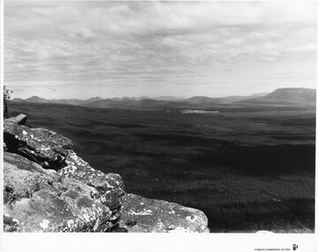 Halls Gap & Grampians Historical Society
Photograph - B/W
Photo is of Moora Moora in the Victorian Valley. Typical of the time as a promotional image taken by Forests Commission Victoria.View over a large Valley with ranges in the distance. Roads through the valley are visible and a body of water in the middle right of the photograph. A rocky outcrop is in the left side foreground.Publicity & Public Relations Branch. When reproducing please acknowledge Forests Commission Victoria Negative no. 322-26scenery, grampians ranges -
 Port Melbourne Historical & Preservation Society
Photograph - Port Melbourne breakwater between the piers, Alison Kelly, 1991
Donated to the Society by the photographer Alison KellyColour photograph taken from the Port Melbourne breakwater between the piers looking into the bay. In distance two ships at anchor and the third (on right), the Australian Trader, is outboundtransport - shipping, australian trader -
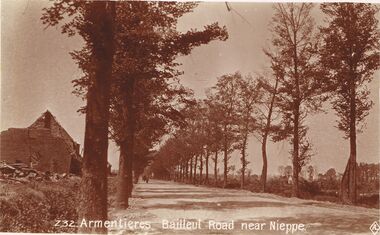 Bendigo Historical Society Inc.
Postcard - ACC LOCK COLLECTION: ARMENTIERES BAILLEUL ROAD NEAR NIEPPE, POSTCARD, 1914-1918
Postcard, WW1, Sepia image of the Armentieres Bailleul road near Nieppe. Road is treelined with a ruined building on the left. Figure and horse and cart in the distance. Copy Z32postcard, postcard, ww1, armentieres, bailleul, nieppe, france -
 Bendigo Historical Society Inc.
Photograph - WES HARRY COLLECTION: UPPER RESERVE DAM/KNIPES CASTLE, 1870's
Photograph depicting the Upper Reserve Dam with an island. Barnard St. is behind a picket fence in the middle distance and Knipes Castle is on the skyline, left hand side of the photo.place, bendigo, knipes castle, upper reserve dam, barnard st, knipes castle -
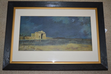 Wangaratta RSL Sub Branch
Framed print, Menin Gate at Midnight
The original art piece was painted by Australian artist Will Longstaff after he attended the unveiling ceremony of the Menin Gate memorial at the entrance of the Belgian town of Ypres in 1927. It was purchased in 1928 for 2000 guineas and presented to the Australia Government by British Philanthropist Lord Woolavington The memorial is inscribed with the names of 54,000 British and Commonwealth soldiers killed in Flanders with no known grave, over 6000 are Australians.The image commemorates those soldiers with no marked graves who died on the Western Front during the First World War.Dark wooden frame with gold gilt inner edge containing cream mount over a dark blue print with large cream coloured arched monument in distance.menin gate, will longstaff, lord woolavington -
Tatura Irrigation & Wartime Camps Museum
Book, Liederbuch, 1940's
A book of German folk songs, made and used in Camp 3. Originally owned by Rudolph and Luise WiedLigh brown soft cardboard cover with black pen sketch of a tree and limbs, boy with a guitar, hills in the distance and sun in the background. Pages held into cover by stringleiderbuch, andersonh, wied l, camp 3, tatura, ww2 camp 3, books, school, education -
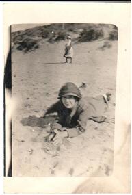 Hume City Civic Collection
Photograph, 1920s
A copy of a snapshot of a woman lying on the sand. She is wearing a hat and coat. Another woman is in the middle distance and is half turned towards the camera. There are sand dunes in the background.headwear, 1920s, george evans collection -
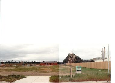 Hume City Civic Collection
Photograph, early 1990s
The series of 5 photographs feature different views of the Woodlands housing development which opened up land bounded by Gap and Anderson Roads, Cornish Street and Elizabeth Drive in the early 1990s. It was a large housing development built close to Sunbury township.A coloured photograph of a new housing development taken in Anderson Road looking west towards Elizabeth Drive and the leisure centre. Some housing construction is in the middle distance.housing developments, anderson road, george evans collection -
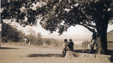 Mt Dandenong & District Historical Society Inc.
Photograph, FiveWays, Kalorama Looking Towards Silvan Dam, c1930
Close up of elm tree at FiveWays with a man and woman seated on stone bank and a man standing under the tree. Silvan Dam visible in distance. (2 copies)fiveways, kalorama, silvan dam -
 Kew Historical Society Inc
Photograph - Second Johnston Street Bridge in Flood, 1934
Original, small black and white print photograph of crowds lining the Johnston Street Bridge watching the flood waters below. The annotation on the reverse clarifies that Kew is in the distance.Annotated on reverse: "Gift of G.S. Beard / 2nd bridge / Johnston St. Studly Park Rd. Bridge looking towards Kew / 1st bridge 1858–1876, 2nd bridge built (bad bend), 1876–1958, 3rd bridge 1958, lined up Johnston St and Studley Park Rd."johnston street bridge, bridges - yarra river -- kew (vic.), flood -- 1934 -
!['Reno', St John's Parade [Kew]](/media/collectors/550653872162f11fb04854aa/items/658d16120f23e8f1e738df53/item-media/658d16680f23e8f1e738e098/item-fit-380x285.jpg) Kew Historical Society Inc
Kew Historical Society IncPhotograph - 'Reno', St John's Parade [Kew], c. 1965
‘Reno’, stood on the east side of St John’s Parade. Its earliest recorded owner was the architect Samuel Cocking who lived there from c.1865 until his death in 1888. The original landholding was bordered by Cotham Road, Glenferrie Road, Wellington Street, and Charles Street. The garden including rare plants supplied by Baron Von Mueller, surrounds the cottage in a tangled frenzy. Despite a ‘local significance’ classification by the National Trust, the house was demolished in 1977.This work forms part of the collection assembled by the historian Dorothy Rogers (1905-1973), donated to the Kew Historical Society by her son in 2015. The manuscripts, photographs, maps, and documents were sourced by her from both family and local collections or produced as references for her print publications. Many were directly used by Rogers in writing ‘Lovely Old Homes of Kew’ (1961) and 'A History of Kew' (1973), or the numerous articles on local history that she produced for suburban newspapers. Most of the photographs in the collection include detailed annotations in her hand. The Rogers Collection provides a comprehensive insight into the working habits of a historian from the 1960s to the 1970s. Original monochrome photograph of Reno, St John's Parade, Kew. Pictured are the garage in the distance at left, the weatherboard house with its simple verandah, and the overgrown front garden.Annotation verso: "Reno. St Johns Parade. Reno. Miss Green".dorothy rogers, reno.-- st john's parade (kew) -
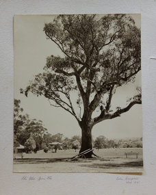 Kew Historical Society Inc
Photograph, Colin Campbell, The Old Gum Tree, 1961
In 1871, Victoria Park, beside the Boroondara General Cemetery was set aside as a public reserve. As the Park developed, exotic plants were added to existing specimens. In 1910, a photograph of ‘The Oldest Inhabitant: A Giant Red-gum Tree’ in the Park was included in the Jubilee History of Kew. Fifty-one years later the tree was re-photographed by Colin Campbell. A 2007 Master Plan developed for the City of Boroondara advises the retention of this now dead River Red Gum, including a ‘managed risk zone’ and planting under the heavily lopped tree.‘The Old Gum Tree’ in Victoria Park. In the distance a game of cricket is being played on the oval. The old grandstand can be seen in the photo. Photographer Colin Campbell 1961. THE OLD GUM TREE / COLIN CAMPBELL KEW 1961victoria park (kew), colin campbell (photographer), victoria park, red gum tree, eucalypts, kew (vic.) -- historic trees