Showing 1135 items matching " east kew"
-
 Melbourne Legacy
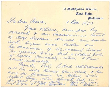
Letter, Legatee Savige to Legatee Aaron Beattie, 1950
... gothic font '9 Goldthorns Avenue, East Kew, Melbourne.... '9 Goldthorns Avenue, East Kew, Melbourne. Cream note dated 1 ...A letter from Legatee Savige to Legatee Aaron Beattie. It appears to be a reply to a letter congratulating him on his knighthood in 1950.A record of a note between Legatees.Cream note dated 1 December 1950 from Stan Savige to Aaron Beattie.Note card is printed with Stan Savige's address in blue gothic font '9 Goldthorns Avenue, East Kew, Melbourne.stan savige, aaron beattie -
 Melbourne Legacy
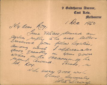
Letter, Legatee Savige to Legatee Roy, 1950
... gothic font '9 Goldthorns Avenue, East Kew, Melbourne.... in blue gothic font '9 Goldthorns Avenue, East Kew, Melbourne ...A note from Legatee Savige to Roy, presumably a Legatee. It appears to be a reply to a letter congratulating him on his knighthood in 1950. Part of the note says: "an earlier reply to the nice letters received from fellow legatees, among which I appreciated yours greatly in your good wishes on the occasion of the recent award. Thanks a lot, Roy. With every good wish, Yours sincerely, Stan Savige."A record of a note between Legatees.Cream note dated 1 December 1950 from Stan Savige to Roy - presumably a Legatee.Note card is printed with Stan Savige's address in blue gothic font '9 Goldthorns Avenue, East Kew, Melbourne.stan savige, knighthood -
 Kew Historical Society Inc
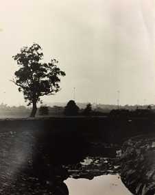
Photograph - Yarra in Flood from Willsmere, North Kew, 1923
... Kew East (vic.)... of the Yarra bordering Kew and Kew East in the north and west... bordering Kew and Kew East in the north and west of the municipality ...Flooding of the Yarra Valley, including that section of the Yarra bordering Kew and Kew East in the north and west of the municipality, was a regular occurrence. Extreme flood events of the Yarra River are recorded to have occurred in 1891, 1901, 1916, 1923 and 1934. The Municipality of Kew's response to these floods was to enact planning decisions restricting residential development in flood prone areas following the floods of 1916, 1921 and 1934. While floods continued after the development of the Upper Yarra Reservoir (construction 1948-57), the regularity and extent of these inundations diminished. Original, large sepia photograph showing men, women and children who have gathered on a grassy verge, probably farm land, to look out across the flooded Yarra Valley at Willsmere, North Kew. In the medium distance are three houses that are largely submerged by the flood waters as well as a number of Eucalypts. Judging by the clothes of the spectators, the date might be 1901 or 1916, but probably the latter due to the hats worn by a number of the women. Inscribed reverse: "Gift of Kerrie Woollard (KCC) (P)C.1923yarra river valley, kew east (vic.), floods, willsmere -
 Kew Historical Society Inc
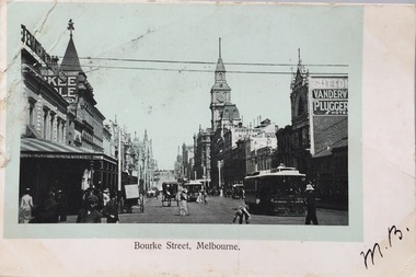
Postcard, Bourke Street, Melbourne, 1920-1920
... Mrs L. Clark, Ecclesbourne, Harp Road, East Kew / Wishing...) photographic postcards Mrs L. Clark, Ecclesbourne, Harp Road, East Kew ...The Kew Historical Society's postcard collection includes views of Kew, Melbourne and Greater Melbourne as well as those including overseas scenes sent or received from Europe or the Middle East. They date from the 1890s to the 2000s. These postcards may or may not include the name of the publisher or printer. A number of the cards were published as parts of popular series. A way of dating early postcards is to identify whether the reverse was divided by a central line which became the norm after 1902 in the United Kingdom. However, other postcards produced after this date do not always conform to this print layout.Monochrome postcard of Bourke Street, Melbourne, looking west from Swanston Street. The costumes of the women in the photograph would indicate the use of an earlier photograph dating from the 1885-1895.Mrs L. Clark, Ecclesbourne, Harp Road, East Kew / Wishing you many happy returns of the Day, M. Boylebourke street - melbourne, postcards -- melbourne (vic), photographic postcards -
 Ballarat Heritage Services
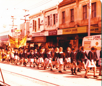
digital copy, K.P. Gervasoni, Kew Festival Parade St Anne's c1979, 1979
... School East Kew marching in High Street during the Kew Festival... photograph of students of St Anne's Primary School East Kew marching ...Copy of colour photograph of students of St Anne's Primary School East Kew marching in High Street during the Kew Festival. Lisa Gervasoni is in the centre left of shot, wearing a blazer and caught in mid march.kew, gervasoni, festival, parade, school, st anne's, primary, march, lisa, kew festival, lisa gervasoni -
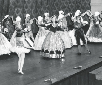 Melbourne Legacy
Photograph, Annual Demonstration
... Stamped "Leslie Thomspon / 8 Keystone Cres / East Kew WL... demonstration Stamped "Leslie Thomspon / 8 Keystone Cres / East Kew WL ...A photo of a junior legatees in elaborate ballgowns and old fashioned outfits, and wigs dancing on stage at the Annual Demonstration. Central characters appear to be a queen and a girl in a tutu as part of a dramatic dance routine. Legacy clubs ran classes for junior legatees for many years such as gymnastics, swimming or dancing classes. It was part of providing for the children of their deceased comrades. The skills they learned were show cased in an annual demonstration usually at the Melbourne Town Hall. It appears to be photo taken professionally of the Annual Demonstration. Year unknown.A record of a way Legacy provided classes for junior legatees and the skills learned were displayed in the Annual Demonstration.Black and white photo of junior legatees in ball gowns dancing on stage at Melbourne Town Hall.Stamped "Leslie Thomspon / 8 Keystone Cres / East Kew WL 3078" in purple ink. Handwritten 'Legacy P2' in blue pen.junior legatee, annual demonstration -
 Kew Historical Society Inc
Biographical information, Ronald Horace Setford (1915–1988)
... 9 Tanner Avenue -- Kew East (Vic... Avenue, East Kew, part of the Old Golf Links Estate, for £225... Avenue, East Kew, part of the Old Golf Links Estate, for £225 ...Ronald Horace Setford was born in April 1915 at 18 Church Street, Hawthorn, at his family’s home above their decorator shop. He was the second of three sons born to Horace Turner Setford (1880-1944) and Mabel Crofts (1887-1943). He attended Hawthorn West Primary School and then Swinburne before beginning work in his family’s business ‘Setford and Son’ in October 1930. This was formalised in April 1931 when he became a carpentry and joinery apprentice. In 1934 he graduated as a grade four carpenter. Ron worked in the family business until 1964 and then worked at J S Kidd and Co Pty Ltd as a storeman until his retirement in December 1973. Ron married Grace Muriel Agnes Perrey (1915-2001) in 1936 and they first lived in Kew around 1940, at 38 Marshall Avenue. Ron served in the Citizen Military Forces as a sapper with the 9 Australian Army Transport Company, Royal Australian Engineers, signing up a week after Darwin had been bombed. He spent time in Darwin, Wayville (South Australia), Herberton and Grovely (Queensland). Afterwards he refused to eat rice, never spoke of the war, nor took part in any ANZAC day proceedings. In 1941, Ron and Grace bought their block of land at 9 Tanner Avenue, East Kew, part of the Old Golf Links Estate, for £225. It was not until December 1945 that Ron started building their home and they moved in during May 1947. Ron and Grace remained there for thirty-seven years until the house was sold to their nephew in 1984. It has since been demolished. Ron’s great passion was photography and in the early 1960s he purchased his Minolta camera. Slide evenings at Tanner Avenue were a regular occurrence. Ron made his own title slides, interval slides and end slides. As well as many holiday photos (around Australia and their world trip in 1966), he enjoyed photographing local landmarks, flowers, insects and family. One of Ron’s photography projects was to record the progress of the building of the Eastern Freeway. This was near their home, and he’d walk down to the works on a regular basis, dressed smartly, with his camera in hand. The workers thought he was an official photographer, and he was allowed on site to take his photos. In 1984, Ron and Grace downsized and moved to Bayswater. Ron passed away on 31 October 1988 at the Maroondah Hospital in Ringwood East, at age 73. His ashes were spread on his beloved rose bushes at Tanner Avenue. Lauren Thomson, 2025ron setford, 9 tanner avenue -- kew east (vic, setford and son -- 18 church st (hawthorn), grace muriel agnes perrey, 9 australian army transport company, j s kidd and co pty ltd, eastern freeway, f19 freeway -
 The Beechworth Burke Museum
Photograph, c.2000
... town north-east victoria kew asylum ararat asylum Reverse: AGFA ...This photograph was captured on an undisclosed date and by an unidentified photographer. It was printed in colour through the company AGFA which is a Belgian-German Multinational Corporation. This business prints, develops, manufactures and distributes digital imaging products, software and systems. It was founded in 1967 and continues to operate today. Beechworth's Mayday Hills was chosen as the site of Victoria's newest asylum, at the time, due to the landscape and altitude. The hilltop atmosphere and the native fauna, it was argued, would assist in the cure of the patients kept at the hospital (Wood 1985, 122). The positioning of the hospital had a beneficial effect on the rural town. A pamphlet published by James Ingram and Son (1849) reveal that famous landmarks in Beechworth which included the Post Office, Gaol, Courthouse and Asylum "demonstrate the appreciation of Beechworth by the Government not only as as important district center, but also as a site unrivaled as a sanitarium". There were other locations in contention at the time, but ultimately Beechworth was chosen (Craig 2000, 33). Prior to the creation of the Asylum in Beechworth, those charged with having mental illnesses or, as it was termed, "insanity" were unable to be properly cared for in the Gaol (which is where they were often sent). John Buckley Castieau wrote, in 1861 for the Ovens and Murray Advertiser, that the Gaol was unable to properly care for those classified then as "insane" but that they would endeavor to treat them above the other inmates (which he notes is not always the case in other establishments). Castieau wrote this in favour of supporting the building of the Mayday Hills Hospital in Beechworth. It was stated that at the time the Mayday Hills Hospital was built, there were 83 prisoners kept in the Gaol who were to be rehoused to the Hospital on the grounds of "insanity". The classification as someone as "insane", in this period of time is a reflection on the inability to cure and understand illnesses of the mind during the mid to late 1800s. Opening on the 24th of October 1867, the Mayday Hills Hospital was originally named the "Ovens Lunatic Asylum", a title which is very much a product of its time. Whilst controversial, changes to the name is part of the history of the Hospital and can provide much insight into the understanding of mental illness throughout history and the use/disuse of this term provides information into the reception/changing opinions of mental illness in society. The Hospital would later become known as the "Mayday Hills Asylum" and/or "Mayday Hills Hospital" with the latter being the most commonly used title. An article in the Ovens and Murray Advertiser notes that on the 7th of March 1865, the foundation stone of the Hospital was laid (it would officially open in 1867) and that it was such a moment of accomplishment and joy for Beechworth that a letter to the editor even suggested that there should be a holiday dedicated to the day the foundation stone as laid. This reveals an extent to which the townspeople of early Beechworth valued the construction of the Hospital in their town. It provided the town with a sense of prestige and honour.At first glance, the remains of the Mayday Hills Hospital in Beechworth, Victoria, inspire tragedy, trauma and beauty. The buildings themselves, with their Italianate style Renaissance architecture designed by J.J. Clark (Craig 2000, 49 & Smith 2016, 203) reflect a bygone period of European and Australian history. The gardens provide a sense of tranquility and beauty. The experience of those within these walls remains a valuable area of study to provide a more complete understanding. This particular hospital is considered the fourth of its like and one of three identified as the largest of their kind. The Mayday Hills Hospital is a sister to the Kew and Ararat Asylums in Melbourne which are both located in relative proximity. Understanding the role of the Mayday Hills Hospital in Beechworth history is integral to understanding the development of the goldfields town, but also for providing important information as to the history of caring for, and the reception of, mental illnesses in Australian and wider European history. Mayday Hills provides a case study which can be researched through oral history, an analysis of the grounds/buildings and through images like this postcard which portray the structure in a highly deliberate manner. Images like this depict the strong façade of the Hospital and provide a glimpse into the tranquility of the gardens. This has been done deliberately to provide a sense of comfort and healing about the building to those looking from the outside. Further research into the importance of the Hospital in Beechworth and it's connection to the town will be supported through images like these kept in the Mayday Hills photo album in the collection of the Burke Museum.Coloured rectangular photograph printed on gloss photographic paper.Reverse: AGFAbeechworth, mayday hills, mayday hills asylum, mental health, history of mental health, asylum, 1860s, gold town, north-east victoria, kew asylum, ararat asylum -
 Melbourne Tram Museum
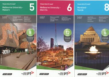
Ephemera - Tram Route Guides, Public Transport Victoria (PTV), "Tram Route Map", 1/2015 and 6/2015
... Coburg South Melbourne East Malvern Kew West Coburg West ...Set of 7 Tram Route Maps, published during 2015. Each comprises a vertical DL folded sheet, full colour for the nominated routes, with Yarra Trams and PTV logos, listing the stops, interchanges with bus and other tram services, ticketing zones, estimated frequencies with adverts for Night tram services, TramTracker and Myki tickets. .1 - Route 5 - Melbourne University to Malvern .2 - Route 6 - Melbourne University to Glen Iris .3 - Route 8 - Moreland to Toorak .4 - Route 11 - West Preston - Victoria Harbour Docklands .5 - Route 19 - North Coburg - Flinders St Station .6 - Route 70 - Wattle Park to Waterfront City Docklands .7 - Route 72 - Melbourne University to Camberwell .8 - Route 1 - East Coburg - South Melbourne Beach .9 - Route 3 and 3A - Melbourne University to East Malvern .10 - Route 16 - Melbourne University to Kew .11 - Route 55 - West Coburg - Domain Interchange .12 - Route 57 - West Maribyrnong - Flinders St Station .13 - Route 59 - Airport West - Flinders St. Station .14 - Route 64 - Melbourne University - East Brighton .15 - Route 67 - Melbourne University - Carnegie .16 - Route 78 - North Richmond - Balaclava via Prahran .17 - Route 82 - Footscray - Moonee Ponds See Reg Item 2396 for 2012, 2278 for 2016 and 2940 for 2014 versionstrams, tramways, timetables, maps, route 1, route 3, route 5, route 6, route 8, route 11, route 16, route 19, route 55, route 57, route 59, route 64, route 67, route 70, route 72, route 78, route 82, east coburg, south melbourne, east malvern, kew, west coburg, west maribyrnong, airport west, east brighton, carnegie, north richmond, balaclava, footscray, moonee ponds, malvern, glen iris, moreland, west preston, north coburg, wattle park, camberwell -
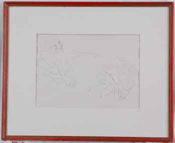 Glenelg Shire Council Cultural Collection
Drawing, Mary Macqueen, Cheetah, c. 1972
... : "Cheetah" $65 Drawing Mary Macqueen Iowen St East Kew 3102 803155... Macqueen Iowen St East Kew 3102 803155 Line drawing of a cheetah ...UnknownLine drawing of a cheetah reclining and looking over its shoulder to the right. Mounted in pale cream matt. In red wooden frame with glass glazing.Front: M. Macq (lower left, signature)(pencil) Back: "Cheetah" $65 Drawing Mary Macqueen Iowen St East Kew 3102 803155 -
 Kew Historical Society Inc
Photograph - K Class 217 (Birney Safety Car) in Doncaster & North Balwyn Village, 1990
... of East Kew Depot".... Original location of East Kew Depot" Laminated colour enlargement ...This colour photograph, with 15 others are enlargements gifted to the Society by Mel Lawrence in 2016. They were taken at a commemorative event from the Kew Tram Depot. Laminated colour enlargement of a K Class 217 (Birney Car) in Doncaster & North Balwyn Village taken at a re-enactment from the Kew Depot in 1990.Annotation reverse: "Kew Depot 1990. K Class 217 (Birney Car) in Doncaster & North Balwyn village. Original location of East Kew Depot"kew tram depot, k class trams, birney safety car -
 Port Melbourne Historical & Preservation Society
Document - Contract of Sale for 84 Dow Street, Port Melbourne, Law Institute of Victoria, 8 July 1982
... Fleming BARLOW of East Kew to Sydney William NEWMAN for the sum... BARLOW of East Kew to Sydney William NEWMAN for the sum of 875 ...The 1928 Contract of Sale is for the land which became 84 Dow Street, Port Melbourne. The land was sold by Catherine Fleming BARLOW of East Kew to Sydney William NEWMAN for the sum of 875 pounds. The deposit was 100 pounds with a quarterly re-payment of 10 pounds.Purchase completeddow street, built environment - domestic -
 Kew Historical Society Inc
Plan - Subdivision Plan, Belford Heights Estate, Kew, ca. 1925
... The Belford Heights Estate was a subdivision in Kew East... of the City of Melbourne. Most of these are of Kew, Kew East ...Pru Sanderson, in her groundbreaking ‘City of Kew Urban Conservation Study : Volume 2 - Development History’ (1988), summarised the periods of urban development and subdivisions of land in Kew. The periods that she identified included 1845-1880, 1880-1893, 1893-1921, 1921-1933, 1933-1943, and Post-War Development. These periods were selected as they represented periods of rapid growth or decline in urban development. An obvious starting point for Sanderson’s groupings involved population growth and the associated economic cycles. These cycles also highlighted urban expansion onto land that was predominantly rural, although in other cases it represented the decline and breakup of large estates. A number of the plans in the Kew Historical Society’s collection can also be found in other collections, such as those of the State Library of Victoria and the Boroondara Library Service. A number are however unique to the collection.The Kew Historical Society collection includes almost 100 subdivision plans pertaining to suburbs of the City of Melbourne. Most of these are of Kew, Kew East or Studley Park, although a smaller number are plans of Camberwell, Deepdene, Balwyn and Hawthorn. It is believed that the majority of the plans were gifted to the Society by persons connected with the real estate firm - J. R. Mathers and McMillan, 136 Cotham Road, Kew. The Plans in the collection are rarely in pristine form, being working plans on which the agent would write notes and record lots sold and the prices of these. The subdivision plans are historically significant examples of the growth of urban Melbourne from the beginning of the 20th Century up until the 1980s. A number of the plans are double-sided and often include a photograph on the reverse. A number of the latter are by noted photographers such as J.E. Barnes.The Belford Heights Estate was a subdivision in Kew East, even though the title of the plan indicates that it was located in Kew. The subdivision had been approved by 1915, and included 105 lots facing Strathalbyn, Kitchener, Hamilton and Beresford Streets, as well as Balfour and Belford Roads. Those lots hand coloured with red probably represent blocks that had been sold. The additional information provided on the plan is also of interest. The plan includes the original location of East Kew State (Primary) School in Strathalbyn Street, which opened in 1892. The inset Locality Plan also includes the route of the Outer Circle Railway and the location of the Wilsmere and East Kew Stations. The location of the landmark Harp of Erin Hotel is also marked on the Locality Plan.belford heights estate, subdivision plans - kew -
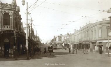 Melbourne Tram Museum
Photograph - Black and white - High St Kew c1920's
... Shows High St Kew, looking east from the junction...Black and white photograph of High St Kew, looking east... Shows High St Kew, looking east from the junction with a four ...Shows High St Kew, looking east from the junction with a four wheel tram approaching the intersection with people waiting to board the tram. On the right is a sign "Happy Thoughts - the trade supplied" and under it "Lucy Hinton Tobacco"Yields information about the location, the streetscape and the trams and vehicles in use at the time. Black and white photograph of High St Kew, looking east with a four wheel tram in the view."RSCP 328" & "C1918" in pencil on rear.tramways, trams, kew junction, high st kew, tram stops -
 Kew Historical Society Inc
Plan - Subdivision Plan, Maxwelton, Kew, 1920-1940
... The subdivision, ‘Maxwelton’, included four lots in East... of the City of Melbourne. Most of these are of Kew, Kew East ...Pru Sanderson, in her groundbreaking ‘City of Kew Urban Conservation Study : Volume 2 - Development History’ (1988), summarised the periods of urban development and subdivisions of land in Kew. The periods that she identified included 1845-1880, 1880-1893, 1893-1921, 1921-1933, 1933-1943, and Post-War Development. These periods were selected as they represented periods of rapid growth or decline in urban development. An obvious starting point for Sanderson’s groupings involved population growth and the associated economic cycles. These cycles also highlighted urban expansion onto land that was predominantly rural, although in other cases it represented the decline and breakup of large estates. A number of the plans in the Kew Historical Society’s collection can also be found in other collections, such as those of the State Library of Victoria and the Boroondara Library Service. A number are however unique to the collection.The Kew Historical Society collection includes almost 100 subdivision plans pertaining to suburbs of the City of Melbourne. Most of these are of Kew, Kew East or Studley Park, although a smaller number are plans of Camberwell, Deepdene, Balwyn and Hawthorn. It is believed that the majority of the plans were gifted to the Society by persons connected with the real estate firm - J. R. Mathers and McMillan, 136 Cotham Road, Kew. The Plans in the collection are rarely in pristine form, being working plans on which the agent would write notes and record lots sold and the prices of these. The subdivision plans are historically significant examples of the growth of urban Melbourne from the beginning of the 20th Century up until the 1980s. A number of the plans are double-sided and often include a photograph on the reverse. A number of the latter are by noted photographers such as J.E. Barnes.The subdivision, ‘Maxwelton’, included four lots in East Kew, at the northwest corner of Burke Road and Cotham Road. Lot 3 is identified as the location of an existing house. The site of the subdivision equates to that parcel of land where a contemporary block of three storey apartments at 1245 Burke Road is now located.subdivision plans - kew, mazwelton subdivision, burke road -- kew (vic.), cotham road -- kew (vic.) -
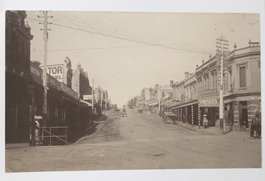 Kew Historical Society Inc
Photograph, High Street, Kew, 1891
... Early photograph of High Street, Kew, looking east from Kew... Early photograph of High Street, Kew, looking east from Kew ...Early photograph of High Street, Kew, looking east from Kew Junction.High Street, Kew, circa 1891.high street, kew, kew junction, streets -- kew (vic) -
 Kew Historical Society Inc
Photograph - 8 roomed DF Brick Villa, Kew, J E Barnes, c.1920
... of the photograph is a subdivision plan for the Normanby Estate, East Kew... is a subdivision plan for the Normanby Estate, East Kew - 2016.0039.1 ...Subdivision plans are historically important documents used as evidence of the growth of suburbs in Australia. They frequently provide information about when the land was sold on which a built structure was subsequently constructed as well as evidence relating to surveyors and real estate and financial agents. The numerous subdivision plans in the Kew Historical Society's collection represent working documents, ranging from the initial sketches made in planning a subdivision to printed plans on which auctioneers or agents listed the prices for which individual lots were sold. In a number of cases, the reverse of a subdivision plan in the collection includes a photograph of a house that was also for sale by the agent. These photographs provide significant heritage information relating house design and decoration, fencing and household gardens. The photograph is of additional aesthetic significance as it was photographed by J. E. Barnes. Josiah Earl Barnes is a nationally significant photographer. He was also the most important photographer to have worked in Kew. He was active as a photographer in the district from c.1906 until his death in 1921. Best known as 'the Embarkation Photographer' (see the Australian War Memorial collection), J. Earl Barnes was also the official photographer employed by the Borough (and later Town, then City) of Kew. He clearly also completed commercial jobs for local businesses, as is the case in this photograph of a house for a local real estate and financial agent.A photograph, mounted on board of a double fronted Federation-era brick villa in Kew, photographed for a local real estate agent and financier by J. E. Barnes of Kew. On the reverse of the photograph is a subdivision plan for the Normanby Estate, East Kew - 2016.0039.1. As can be seen from the image, there is a large tear on the surface of the photograph.The brown card on which the photograph is mounted includes the following handwritten description, which may aid the identification of the house: "Kew, 3 minutes from tram, 8 roomed DF Brick Villa, tile roof including two attics, sleepout, bathroom, heater, E Light, Entrance Hall, double doors, leadlights, laundry, garden, lawns, land 75 x 170, 1975 pounds". Also photographers inscription on mount, lower left: J. E. Barnes / Photo / Phone 1966 Haw. KEW.j. e. barnes, josiah earl barnes, j. earl banes - photographer, architecture - federation style, houses - kew, real estate photographs -
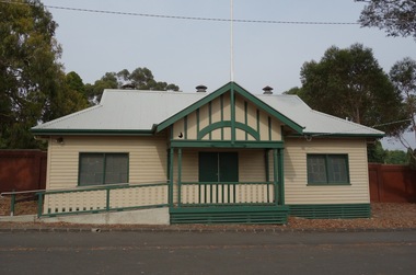 Kew Historical Society Inc
Photograph - Digital Photograph, Robert Baker, Harriers' Pavilion, Victoria Park (Kew), 2014, 2014
... of community groups, including the East Kew Women's Club.... of community groups, including the East Kew Women's Club. kew - sport ...While initially a pavilion at Victoria Park used by the Kew Harriers Club, the building was subsequently used by a range of community groups, including the East Kew Women's Club.Born digital image of the exterior of the renovated Harriers' Pavilion at Victoria Park (Kew)kew - sport pavilions, victoria park - kew (vic), kew harriers club -
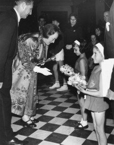 Melbourne Legacy
Photograph, Leslie Thomson, Annual Demonstration 1970, 1970
... Thompson 8 KEYSTONE CRES. EAST KEW WL 3078. ... Thompson 8 KEYSTONE CRES. EAST KEW WL 3078. Black and white photo ...Photograph of two Junior Legacy performers in costumes presenting flowers to Lady Delacombe, the wife of the Governor of Victoria - Sir Rohan Delacombe. One of the girls is Carmen Ellul, the other's name is not known. By the inscription it was at the Legacy on Parade in 1970 at the Melbourne Town Hall.A record of a Junior Legacy Demonstration being attended by the Governor of Victoria and his wife.Black and white photo of Junior Legacy performers presenting flowers to the Governor's wife.Back side of photo: Hand written 25 / Hand written, Legacy on Parade 1970 Lady Delacombe [Sign inserted] / Stamp, Leslie Thompson 8 KEYSTONE CRES. EAST KEW WL 3078. lady delacombe, legacy demonstration, governor of victoria -
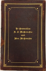 Kew Historical Society Inc
Document - Invitation, To Councillor A.J. McConchie and Mrs McConchie, 1928
... of the East Kew church, of which he was a trustee for 29 years. He... of the East Kew church, of which he was a trustee for 29 years. He ...Alan J. McConchie, a manufacturer’s agent, was elected to Kew Council in 1924, serving as a councillor for 21 years. He was elected Mayor of Kew in 1927-28, and again in 1945-46. During his second term as Mayor, he gained the support of Council for a pre-school plan which was the first of its kind in Victoria. The scheme established nursery schools and kindergartens as an extension of the existing baby health centres. Alan McConchie was active in Methodist Church work, and was one of the founders of the East Kew church, of which he was a trustee for 29 years. He was well known in the district as a cricketer and was a founder and past president of the East Kew Bowling Club. A Resident of Strathalbyn Street, he died in 1945 aged 60, while attending morning service at the East Kew Methodist Church. He is buried in the Burwood Cemetery. Handmade illuminated invitation to a notable Kew Mayor and MayoressAn illuminated invitation sent to the Mayor and Mayoress of Kew, Cr. and Mrs. McConchie, by a Citizens Committee to a Ball in the Kew Recreation Hall on 26 July 1928. The double page invitation is encased in an embossed maroon leather cover. The invitation was donated to the Society by a descendant of the McConchies in 2014.Inscription Cover: "To Councillor A.J. McConchie and Mrs McConchie". Inside cover in watercolour: "The Chairman Councillor George Ramsay and Members of the Citizens Committee desire the honor of the Company of HIS WORSHIP THE MAYOR OF KEW AND MRS. McCONCHIE at a BALL to be held in the Kew Recreation Hall Tuesday 26th July 1928 at 8 P.M. Tendered to them as a mark of recognition of the services rendered to the City during their Mayoral Year 1927".cr. a. j. mcconchie, mayor of kew (1927-28, 1945-46) -
 Kew Historical Society Inc
Plan - Subdivision Plan, Myrtle Park Estate, City of Camberwell, 1916
... of these are of Kew, Kew East or Studley Park, although a smaller number... newspapers as being in East Kew, rather than in Camberwell, where... of these are of Kew, Kew East or Studley Park, although a smaller number ...The Kew Historical Society collection includes almost 100 subdivision plans pertaining to suburbs of the City of Melbourne. Most of these are of Kew, Kew East or Studley Park, although a smaller number are plans of Camberwell, Deepdene, Balwyn and Hawthorn. It is believed that the majority of the plans were gifted to the Society by persons connected with the real estate firm - J. R. Mathers and McMillan, 136 Cotham Road, Kew. The Plans in the collection are rarely in pristine form, being working plans on which the agent would write notes and record lots sold and the prices of these. The subdivision plans are historically significant examples of the growth of urban Melbourne from the beginning of the 20th Century up until the 1980s. A number of the plans are double-sided and often include a photograph on the reverse. A number of the latter are by noted photographers such as J.E. Barnes.The ‘Myrtle Park Estate’ was a subdivision bounded by Victoria Road (now Lansdowne Street), Buchanan Avenue and Dight Avenue. Other streets that were created by the subdivision included Eurolie Street, Boorahman Street and Moody Street (now Sylvan Street). The Estate took its name from Myrtle Park (later changed to Macleay Park), which had been created in 1923 by Camberwell Council. The Park adjoined the southeast corner of the new subdivision. The Estate included 74 regular allotments characterised by narrow frontages and long blocks. Confusion may have greeted prospective purchasers as the Estate was advertised in the daily newspapers as being in East Kew, rather than in Camberwell, where it was at that stage located.subdivision plans - balwyn, myrtle park estate - camberwell [surrey hills] -
Kew Historical Society Inc
Archive (Sub-series) - Subject File, Barnard Grove (Kew), 1985
... barnard grove - kew east (vic.)... sources. barnard grove - kew east (vic.) Archive file containing ...Dorothy Benyei & Rosemary SmartReference, Research, InformationKHS OrderSubject file containing responses to a survey of residents of Barnard Grove, Kew (Vic), issued in 1985. The questionnaire requested information about when the respondee/s moved into the street, whether alterations had been made to their house, the reason why they moved to Barnard Grove, its good points and its limitations, and further comments. Rosemary Smart and Dorothy Benyei conducted the survey on behalf of the Society. The file contains many interesting responses from those who returned the surveys.barnard grove - kew east (vic.)barnard grove - kew east (vic.) -
Kew Historical Society Inc
Archive (Sub-series) - Subject File, Bicycle Paths, 1958
... willsmere park - kew east (vic.)... sources. bicycle paths - kew (vic.) willsmere park - kew east (vic ...Various partiesReference, Research, InformationKHS OrderSmall file containing two newspaper articles, the first a general article on cycling and the other on opposition to bike paths in Willsmere Park.bicycle paths - kew (vic.), willsmere park - kew east (vic.)bicycle paths - kew (vic.), willsmere park - kew east (vic.) -
Kew Historical Society Inc
Archive (Sub-series) - Subject File, Billabong - Willsmere Park, 1958
... billabong - willsmere park - kew east... sources. billabong - willsmere park - kew east billabongs - yarra ...Various partiesReference, Research, InformationKHS OrderNewspaper articles/clippings relating to the desire to save the Billabong at Willsmere Park in Kew. The file includes articles with a more general focus relating to bike paths and Willsmere Park generally.billabong - willsmere park - kew east, billabongs - yarra riverbillabong - willsmere park - kew east, billabongs - yarra river -
Kew Historical Society Inc
Archive (Series) - Subject File, Eastern Freeway (Kew), 1979
... kew east (vic) - community groups... sources. kew (vic) - history kew east (vic) - community groups kew ...Organisation generatedReference, Research, InformationSecondary Values (KHS Imposed Order)Subject file containing sundry newspaper files about protests against the freeway’s construction, land acquisition, speeding, noise etc. There is also a CRB brochure of ‘Your Eastern Freeway Driver’s Guide’kew (vic) - history, kew east (vic) - community groups, kew (vic) - roadskew (vic) - history, kew east (vic) - community groups, kew (vic) - roads -
Kew Historical Society Inc
Archive (Sub-series) - Subject File, Kew Historical Society et al, HUSTON, Betty, 2000
... volunteer defence corps - kew east (vic)... - kew east (vic) Archive file containing a three page typed ...Various partiesReference, Research, InformationSecondary Values (KHS Imposed Order)Subject file containing a three page typed monograph by Betty Huston entitled: ‘My early memories of Kew’. In addition to descriptions of houses and family members the document also lists her friends at Ruyton Girls School.kew historical society - archives, kew - history, kew historical society - members, ruyton girls school - former students, sands & mcdougall pty ltd, sackville guest house, 20 wimba avenue - kew (vic), heather menzies, joan wardrop, olive hay-zakharov, valda vaughan, carr’s motor service, 17 alfred street - kew (vic), fay pearce, faye marles, st hilary’s - kew (vic), r vernon francis, st hilary’s choir - kew (vic), volunteer defence corps - kew east (vic)kew historical society - archives, kew - history, kew historical society - members, ruyton girls school - former students, sands & mcdougall pty ltd, sackville guest house, 20 wimba avenue - kew (vic), heather menzies, joan wardrop, olive hay-zakharov, valda vaughan, carr’s motor service, 17 alfred street - kew (vic), fay pearce, faye marles, st hilary’s - kew (vic), r vernon francis, st hilary’s choir - kew (vic), volunteer defence corps - kew east (vic) -
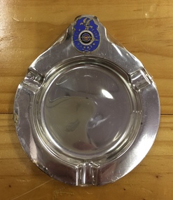 Kew Historical Society Inc
Souvenir, Ashtray, Kew City Bowmen
... hays paddock - kew east (vic)... city bowmen archery hays paddock - kew east (vic) Kew City ...A round plated metal dish with 3 equally spaced indentations for cigarettes and a Kew City Bowmen enamelled badge attached. The badge has a flapping bird standing on a four ringed target enamelled in white, navy blue, green and red rings, a bow superimposed surrounded by Kew City Bowman with 2 crossed arrows below on a mauve blue background.Kew City Bowmankew city bowmen, archery, hays paddock - kew east (vic) -
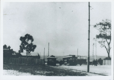 Kew Historical Society Inc
Photograph - Harp of Erin Tram Terminus, 1977
... trams - kew east... trams - kew trams - kew east Black and white print enlargement ...An electrified tram route from Melbourne along High Street replaced an original Horse Tram that terminated at the Kew Cemetery. This new tram only reached the bridge over the Outer Circle railway at the Harp Junction. The line was later extended to North Balwyn.Black and white print enlargement of the Tram Terminus in High Street, Kew at the Harp of Erin hotel. The rear of the photograph identifies it as an enlargement donated by Stewart West from an original owned by Miss Foley.tramways, mmtb, tram terminus, no 48 tram route, harp of erin hotel, trams - kew, trams - kew east -
 Kew Historical Society Inc
Photograph, City of Kew, Eastern Freeway from Hays Paddock, Kew, c.1980
... hays paddock - kew east (vic).... eastern freeway - kew hays paddock - kew east (vic) From Kew City ...One of a series of photos created for an exhibition by the City of Kew of notable locations. The photos represent a snapshot in time.Enlarged photograph of the Eastern Freeway from Hays Paddock, Kew, mounted on board, and donated to the Kew Historical Society by the City of Kew on 10 April 1991. From Kew City C'cil 10 April 1991. ?Freeway at Hayes Paddock. eastern freeway - kew, hays paddock - kew east (vic) -
 Kew Historical Society Inc
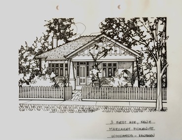
Drawing - Property Illustration, Margaret Picken, 3 First Avenue, Kew, 1997
... 3 first avenue -- kew east (vic.)... — buildings — kew (vic.) 3 first avenue -- kew east (vic.) 3 FIRST AVE ...After training as a Cartographic Draftsman within the mining industry, I worked as a property illustrator for real estate firms in the eastern suburbs of Melbourne for 23 years from 1983. I initially photographed houses with a Polaroid camera and made a 'thumbnail' sketch while there. The photos were used to scale off a sketch in pencil and then that sketch was overlaid with drafting film and the 'pen and ink' completed. The pens I used were the Rotring ‘Rapidigraph’ drafting pens. The ink was also made by Rotring (German).The film was ‘Rapidraw’, polyester drafting film, double matte. It takes a very fine line and doesn’t bleed. As well as house sketches, there were often floor plans and site plans ordered. Aerial sketches were ordered when the property needed an overall view. (Margaret Picken, 2020)This drawing is one of a series created by Margaret Picken for real estate agents in Melbourne between 1983 and 2006. Each work is signed and dated by the artist.Gift of Margaret Picken, 2020Pen and ink drawing on drafting film of 3 First Avenue, Kew by Margaret Picken.3 FIRST AVE., KEW E / MARGARET PICKEN ~97 / WOODARDS ~ HAWTHORNartist -- margaret picken 1950-, property illustrations — buildings — kew (vic.), 3 first avenue -- kew east (vic.)