Showing 1938 items
matching flood
-
 Kew Historical Society Inc
Photograph - Burgess House, Victoria Street (Abbotsford), 1880-1900
Major floods recurred of the Yarra River on a regular basis. A flood in 1901 destroyed this house in Victoria Street, Abbotsford. Later print copy of an original photograph. Home of C/N Burgess on the south side of Yarra River. The buildings were washed away in a flood in 1901 The house was in the same location as that on which Handley & Tilly was later built. This would locate it on the north side of Victoria Street, Abbotsford between Burnley Street and the Victoria Street Bridge. Photo shows three men and one woman working in an established garden in front of a weatherboard cottage."Home of C/N Burgess on south side of river; washed away in 1901; Handley & Tilly on site"yarra river -- floods, yarra river flood -- 1901, burgess family -- victoria street -- abbotsford (vic.) -
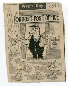 Orbost & District Historical Society
newspaper clippings, February 1971
These articles were compiled by Mary Gilbert who was the first curator of the Orbost Museum and a prominent historian / teacher in Orbost. The 1971 floods at Orbost were the worst on record. At Jarrahmond the river rose to a height of 11 metres and on the flats spread to one and a half kilometres wide. Considerable damage was done to railway infrastructure, roads and farms. More information from the APRIL, 2008 newsletter by John Phillips. (see orbosthistory.com.au)These articles are contemporary records of a significant historical event in Orbost.A manila folder containing black / white newspaper clippings from various publishers. They all relate to the 1971 floods in Orbost. (Details of contents in catalogue 735-900)floods-orbost-1971 -
 Eltham District Historical Society Inc
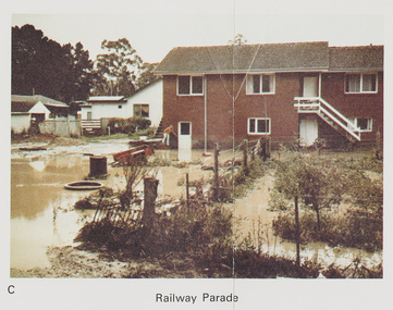
Work on paper (Sub-Item) - Photograph, Flooding, 75 Railway Parade, Eltham 8 April 1977
Colour photograph. Flooding of Diamond Creek at the rear and side of property at 75 Railway Parade, Eltham , 8 April 1977. flood, diamond creek, flooding, eltham, 75 railway parade -
 Charlton Golden Grains Museum Inc
Photograph, Cameron, Ian, c.1973
1973 Flood in High Street Charlton. Bill Landos outside his cafe. Black and white photograph with white boarder.1975 in blue biro written on bottomflood, cba bank, kenny's drapery, bill's cafe, charlton, business -
 National Wool Museum
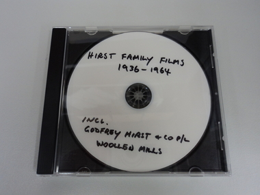
Film - Hirst Family Films, Cedric L Hirst, 1950s
Copy of Godfrey Hirst family videos/photograph on CD. Including 1951 floods at Mill. All video content filmed at Godfrey Hirst Woollen Mill, Swanston Street, South Geelong. Godfrey Hirst's children. Family home in Newtown and holiday home in Eastern View.Compact disc (CD) containing colour video footage. Film has no audio content. Visual content outlined below: 00:00 – 00:05 – External view of brick building – Godfrey Hirst & Co. Pty. Ltd. 00:05 – 00:10 – Exterior garden setting, three men in suits with fabrics and object 00:10 – 00:28 – Exterior garden setting showing eight women, most likely on a break from working at the Godfrey Hirst factory. The footage shows them all getting up and walking back towards the building at the end. 00:28 – 00:38 – Exterior garden setting, showing seven men in white shirts and ties seated and standing around a table, turning pages on a folder on the table. 00:38 – 00:52 – Interior factory setting, showing four men in coats handling green and red wool. 00:52 – 1:08 – Three men in suits in an exterior garden setting looking at paperwork. 1:08 – 1:23 – Four men in coats in a garden handling coloured wool samples. 1:23 – 1:42 – Four men in suits in a garden setting handling woven fabric. Two of the men are holding pipes. 1:42 – 1:57 – Interior factory setting showing men operating machinery. 1:57 – 2:05 – Exterior factory setting showing a man driving machinery carting wool bales. 2:05 – 3:14 - Flood scenes, showing the exterior of the Godfrey Hirst building with a man rowing a boat down the street, and a horse and cart in flood waters. There are scenes of flooded streets, exterior of flooded buildings and people standing in flood waters. 3:14 – 3:40 - Interior building views of flood waters in factory with people, machinery, equipment and textiles in flood waters. 3:40 – 4:03 - Exterior views showing a tractor, boat, horse and people in flood waters. 4:03 – 7:02 Exterior setting showing crowds of people watching a fashion parade. The fashion parade is of women in various clothing, including suits jackets, skirts, coats and hats. 7.02 - END"Hirst family films 1936-1964 Incl. Godfrey Hirst and co P/L Woollen mills"geelong, godfrey hirst & co. pty. ltd., family films, factory, flooding, 1950s, wool processing, fashion, textiles, horse and cart, wool bales, transport, machinery, fashion parade, working life -
 Port Melbourne Historical & Preservation Society
Photograph - Flooded subway at North Port Station, Port Melbourne, 14 Feb 1955
Item appeared on the front page 14.02.1955. In 2002 emails relating to this were received from Sweden, from the child standing in underpants only in the foreground. Image is used in the 2003 Historic Port Melbourne calendar.Lasercopy from original Herald photograph of railway sub-way at North Port Station on Raglan Street in flood, 14 February 1955, showing children from nearby houses swimming in the floodwaters near the underpass.transport - railways, flood, sport - swimming, advertising, business and traders - hotels, sandra svensson nilsson, robert (bobby) farrell, ruth 'bubbles' farrell -
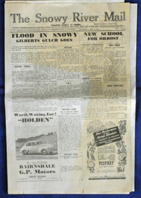 Orbost & District Historical Society
newspaper, 15.2.1950
The Snowy River Mail is a weekly newspaper published in Orbost in the Shire of East Gippsland, Victoria, Australia. Previously published as The Snowy River mail and Tambo and Croajingolong gazette from 1890 to 1911. The Gippsland Courier merged with the Snowy River Mail when proprietor Lachlan Ross moved to Orbost in 1910. In 1999 the paper was acquired by the Yeates family when the Hollins family retired from the newspapers business. The paper is still being produced by the fourth generation of the Yeates family as part of East Gippsland Newspapers. The flood in 1950 was a significant Orbost event. This newspaper is a contemporary record of a significant local events.A Snowy River Mail newspaper dated 15,.2.1950. It contains news articles and advertisements in black/white print. There is an artcle about the Orbost floods.newspaper snowy-river-mail flood-1950-orbost -
Glenelg Shire Council Cultural Collection
Slide - Glass Slide - Horses in a flood, n.d
Glass slide - horses in a flood -
 Melton City Libraries
Photograph, Melton Weir, 1970
Spillway, bridge and river in flood.misc. -
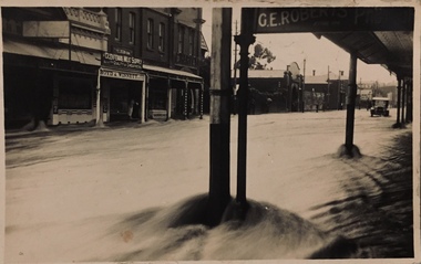
 Bendigo Historical Society Inc.
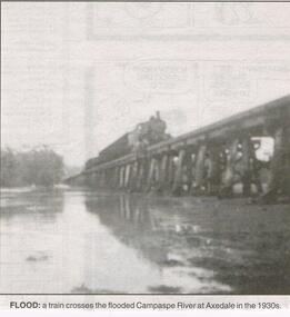
Newspaper - JENNY FOLEY COLLECTION: FLOOD
Bendigo Advertiser "the way we were" from 1999. Flood: a train crosses the flooded Campaspe river at Axedale in the 1930s.newspaper, bendigo advertiser, the way we were -
 University of Melbourne, Burnley Campus Archives
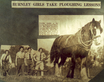
Photograph - Colour print, The Sun, Burnley Girls Take Ploughing Lessons, 1935
Photograph made by A.P. Winzenried as a possible illustration for, "Green Grows Our Garden." There was a severe flood in December 1934.2 copies colour print.. Copy of a newspaper article made by A.P. Winzenried. Caption reads, "Burnley Girls Take Ploughing Lessons. Winter tasks at the Burnley Horticultural School. Students trying their hands at the plough. New top soil had to be laid after the floods." 4 female students working with a horse drawn plough in the Orchard.Handwritten underneath, "R.Weber, E. Pearce, M. Younger, W. Wittakers. "The Sun" 12-6-35."a.p. winzenried, green grows our garden, ploughing lesson, female students, r.weber, e. pearce, m. younger, w. wittakers, orchard, 1934 flood, horse, working outside -
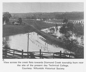 Eltham District Historical Society Inc
Work on paper (Sub-Item) - Photograph, View across the creek flats towards Diamond Creek township
Undated black and white photograph of view across the creek flats towards Diamond Creek township showing the railway line, with the Diamond Creek under flood. Situated behind the vicinity of Diamond Valley College, Main Hurstbridge Road, Diamond Creek. Diamond Valley College was formed in 1989 from the almagamation of Diamond Creek Technical School and Hurstbridge High School. Nillumbik Historical Society collectionflood, diamond creek, nillumbik historical society -
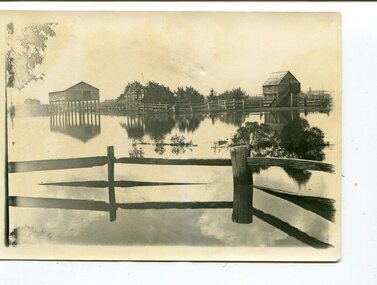
 Kew Historical Society Inc
Photograph, Chipperfield's Boat House & Floating Pontoon, 1934
Living with natural processes was frequently a challenge to early European settlers and later residents of what was in the 1850s administered by the Borondara Road Board. This was compounded by the area being bounded on three sides by rivers (Yarra River, Koonung Creek and Gardiner's Creek). In 1849, the historian James Bonwick recorded that "our district [Kew] suffered considerably. Mr Wade speaks of 80 acres, out of 100 acres of his cultivated paddock, covered by water." Newspapers continued to describe major flooding in Kew in 1863, 1869, 1878, 1880, 1889, 1891, 1916 and 1934. While the construction of the Upper Yarra dam in 1957 reduced the levels of flowing downstream, local and riverine floods continue. A number of boat houses operated on both sides of the River Yarra at Kew. Chipperfield's Boat House was located on the Yarra near the corner of Kilby and Willsmere Roads.The Kew Historical Society's pictures and map collections testify to the impact of flooding in the district. They have historical importance in documenting the extent of flooding in the district and its affects on homes, services and recreation. Numerous photographs record flooding throughout the Twentieth Century.Floating pontoon at Chipperfield's Boat House where the canoes were stored, taken in 1934, presumably before the 1934 Flood. This area of the Yarra was shallow with a number of mid river sandbanks and a popular swimming area for locals.yarra river, chipperfield's boathouse, pontoon -
Glenelg Shire Council Cultural Collection
Slide - Glass Slide - Glenelg River, n.d
Glass slide - Glenelg River in floodslide, photography, glenelg river -
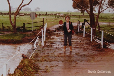 Melton City Libraries
Photograph, Wendy Barrie on the Darlingsford Bridge, 1983
Property of Lot 1 Thomas Bell Darling 1853 1863 Ralph Parkinson 1887 Sold to Richard Manning (Cr and Hotelier) leased by John Walsh Minns family lived at the house in the time of Welsh. C Parkinson died in Jan 1887 Ralph Parkinson was a prominent citizen of Melton and was known for his generosity, and his involvement in the community and the Church of England. He had one daughter, his wife and other daughter died earlier. He died in Jan 1887Photo was taken during the October floodslocal identities, landscapes of significance -
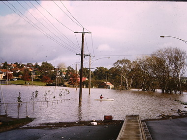
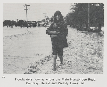 Eltham District Historical Society Inc
Work on paper (Sub-Item) - Photograph, Floodwaters flowing across Main Hurstbridge Road, Diamond Creek Township, 8 April 1977
Black and white photograph of young woman walking through floodwaters, possibly carrying an animal. The Diamond Creek in flood at Diamond Creek township, 8 April 1977 Herald and Weekly Times collectionflood, diamond creek, flooding, herald and weekly times, rescue -
 Kew Historical Society Inc
Postcard - Flood, Glenferrie Road, Hawthorn, 1921
An item from an outstanding and diverse photographic and postcard collection, assembled by members of the Christian and Washfold families of Kew.Flood waters in Glenferrie Road. Glenferrie Meat Supply – Boyd & Winnett opposite. Car in distance in flood waters. Real photo postcardglenferrie road -- hawthorn (vic.), floods -- hawthorn (vic.), christian-washfold collection -
 Kew Historical Society Inc
Photograph - Submerged houses in River Avenue, North Kew, 1934
North Kew, now divided between Kew and Kew East, bordered the Yarra River. As such, it was a region subject to flooding in the Yarra Valley. Development beyond this point (ie Kellett Grove) was limited by the City of Kew's planning regulations. Prior to urban development, the area since European settlement and the first land sales in the district in the 1840s, had been used for dairy farming. Vivid photograph contrasting domestic life and relationships with natural disasters such as the flood of 1934.Small sepia snapshot of two submerged houses belonging to local families in River Avenue, North Kew, during the 1934 floods. The view is presumably from near Kellett Grove looking north towards Fairfield.Verso: COES & HYATTS ROOF / RIVER AVENUE / Stamped: 6414yarra river -- north kew, floods -- yarra valley, floods -- north kew, floods -- 1934, natural disasters -- kew -
 Kew Historical Society Inc
Print - Walmer Street Foot Bridge
A bridge to Walmer Street, Kew, from Abbotsford was located at the northern end of Burnley Street. It was a foot bridge.Photographic print of the Walmer Street Bridge. The view of the Bridge is from the Abbotsford side of the Yarra. A section of pipe on the near side of the bridge is a remnant of the irrigation pipes that carried water from above Dight's falls to the Melbourne Botanic Gardens. The former bridge, constructed in 1896 was swept away in the 1901 Flood. It has two major brick piers while the remainder of the trestle supports are metal. The original photograph from which this copy was made was taken after 1901 as it shows the second bridge under construction. Houses in Young Street, Kew, can be seen on the far side of the river.Written on reverse: "Walmer St. Bridge. Erected 1896. Being rebuilt after 1901 flood damaged it. Houses on left are in Young St."bridges -- kew (vic.), walmer street bridge, melbourne botanic gardens -
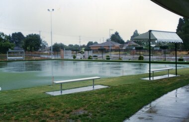 Ringwood and District Historical Society
Photograph, Ringwood Bowls Club - New Ringwood Bowls Club greens flooded, 1997. Photo taken by Jim Bennett
Coloured photograph"Written on back of photograph" Greens flooded. -
 Kew Historical Society Inc
Photograph - Flood, Zig-Zag, Kew, 1924
Henry Beater Christian (1886-1962) , was a descendant of one of the earliest settler families in Kew. Employed at the Kew Asylum as a 'public servant', he was a skilled amateur photographer, photographing numerous scenes in Kew and on his travels around Victoria. The majority of his photographs date from 1916 to 1929. His finest photographs are housed in two photograph albums. A fine and clear view of the Zig-Zag Bridge across the Yarra River.Digital copy of a photograph from page 5 of the 47-page photograph album containing 261 gelatinous silver images, loaned by Diane Washfold with permission given to digitise and hold a copy in our collection. This is a photograph of the 1870s Zig-Zag Bridge that linked the Yarra Bend and Kew Asylums. The Bridge was demolished in 1929."Flood / Zig-Zag / Kew / 1.24"henry beater christian (1886-1962), landscape photography, kew (vic.) — yarra river, christian-washfold collection, photograph albums, zig-zag bridge -
 Kew Historical Society Inc
Photograph - Flooding, Kilby Road, Kew, Ron Setford, 1974
Ron Setford and his wife Grace Setford lived in Tanner Avenue, East Kew, from c.1946 to c.1995. A keen photographer, he recorded the changing face of Kew over a 20 year period. Apart from 30 photographs of built structures and places in Kew dating from 1960 and 1961, 145 of his 35mm colour slides chronicle the development of the Eastern Freeway through the Yarra Valley over a five year period from c.1972 to c.1977. This important collection was donated to the Society by his granddaughter in 2025.This collection of 175 35mm slides is of local and statewide significance, owing to its subject matter, particularly the major development of road transport infrastructure during the 1970s with the construction of the Eastern Freeway. The photographer also took care to annotate and date most of his slides which enable the researcher to pinpoint temporal and spatial locations."Flood Kilby Road / May 74"ron setford, floods -- kew (vic.), kilby road -- kew (vic.) -
 Kew Historical Society Inc
Photograph - Flooding - Kilby Road (Kew), Ron Setford, 1974
Ron Setford and his wife Grace Setford lived in Tanner Avenue, East Kew, from c.1946 to c.1995. A keen photographer, he recorded the changing face of Kew over a 20 year period. Apart from 30 photographs of built structures and places in Kew dating from 1960 and 1961, 145 of his 35mm colour slides chronicle the development of the Eastern Freeway through the Yarra Valley over a five year period from c.1972 to c.1977. This important collection was donated to the Society by his granddaughter in 2025.This collection of 175 35mm slides is of local and statewide significance, owing to its subject matter, particularly the major development of road transport infrastructure during the 1970s with the construction of the Eastern Freeway. The photographer also took care to annotate and date most of his slides which enable the researcher to pinpoint temporal and spatial locations."Flood Kilby Rd / May 74"ron setford, floods -- kew (vic.), kilby road -- kew (vic.) -
 Orbost & District Historical Society
black and white photographs, 1890s
Peter Cameron, came to Orbost in 1885, at the age of 69, having sold his farm at Geelong. Peter bought the property ―Glen Avon from a Mr Street. The home was situated at the bottom of the paddock, near the corner of Morley and Livingstone streets. The farm stretched from Tennyson Street to the end of Snaggers Lane and along the river frontage to “Carinya” Cameron Home. In the Gippsland Times on Wednesday. 2 Jul 1890 on Page 3 is an article titled "THE SNOWY RIVER CALAMITY" which describes an ".unexpectedly sudden rush of water down the flats..... the terrified people commenced to remove their stock from the land and the work of saving property was continued all day ............ many head of cattle were washed away.......The river road, for its entire length, is obliterated, and the approaches to the bridge at Watt's Gulch are gone, with the enormous volume of flood water," These photographs are pictorial records of a significant event in the history of Orbost. There are few personal records of the very early floods.Three black / white photographs of wooden buildings with flood water in foreground. There are post and rail fences. 3193.2 has been taken from a distance.on back -" "Glenavon east of Lagoon 1897 Feb"floods-orbost-1890s glenavon-orbost -
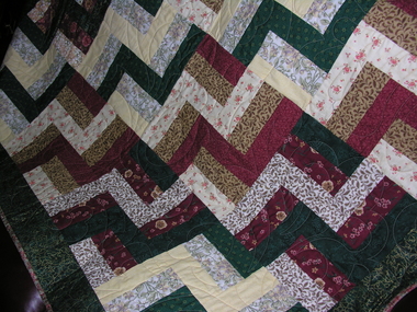 Ballarat Heritage Services
Photograph - Colour, Patchwork quilt made by ladies, Devonport, Tasmania
Photograph of a quilt made for the Carisbrook flood victims. -
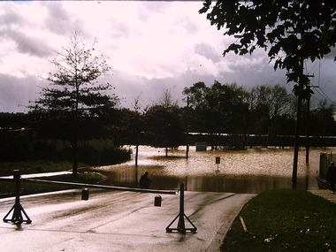
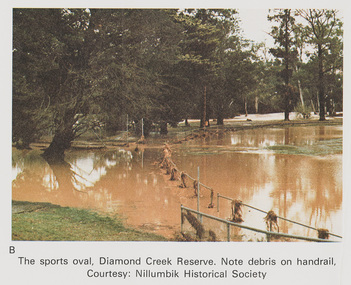 Eltham District Historical Society Inc
Work on paper (Sub-Item) - Photograph, The Sports Oval, Diamond Creek Reserve, Diamond Creek Township, 8 April 1977
Colour photograph. Note debris on the rail fencing around the oval. The Diamond Creek in flood at Diamond Creek township, 8 April 1977 Nillumbik Historical Society collectionflood, diamond creek, flooding, oval, nillumbik historical society, rail -
Kew Historical Society Inc
Postcard - Flood, Glenferrie Road, 1921
An item from an outstanding and diverse photographic and postcard collection, assembled by members of the Christian and Washfold families of Kew.Flood waters in Glenferrie Road. Glenferrie Meat Supply – Boyd & Winnett opposite. Car in distance in flood waters. Real photo postcard. Kodak print.glenferrie road -- hawthorn (vic.), floods -- hawthorn (vic.), christian-washfold collection -
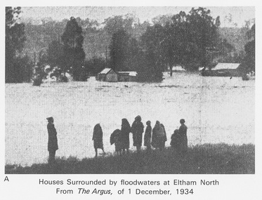 Eltham District Historical Society Inc
Work on paper (Sub-Item) - Photograph, Houses surrounded by floodwaters at Eltham North
"The house (centre) at North Eltham in which Mr. and Mrs. William Frizell, an elderly couple, were marooned by flood waters. When this photograph was taken late yesterday afternoon the couple were still inside the house, and through a ventilator they had stuck a red flag which they waved from time to time. The house on the left belongs to Mr. Leads, who also was marooned." - The Argus 1 December 1934. John William Frizell, painter and his wife Sarah Jane are registered at Glen Park, Eltham in the 1924 Electorial Roll This was most probably the Diamond Creek in flood. In 1934 extensive flooding of the Yarra River and Diamond Creek sets new records for flood plain level (via Chronology of Eltham, EDHS) flood, frizell, leads, argus, glen park, eltham north, flooding, marooned, diamond creek -
 Orbost & District Historical Society
coloured photographs, Hogeman, Trudi, 2000 - 2010
These photographs are of floodwaters on the river flats of Orbost, near Gilberts Gulch on the Marlo Road showing large lumps of wood in the middle of the road and a red vehicle in the background. 3090.4 has been taken looking down onto theSnowy Rive from near Mitchells / Griebenows Road Newmerella.This is a pictorial record of a significant flood event in Orbost.Four panoramic colour photographs showing the aftermath of a flood. flood-orbost-2000s -
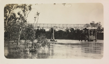
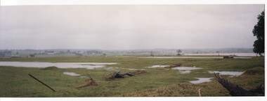
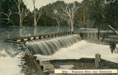 Stawell Historical Society Inc
Postcard, Wimmera River Weir at Glenorchy -- Postcard
Wimmera River Weir Glenorchy with letter written on card and 1d stamp.Coloured post card of a weir along a flooded river. Wier-Wimmera River near Glenorchy addressed to Mrs. G. Wood Hill View Stawell. Message from Oliver dated 8/6/10 plus stamp.water