Showing 1947 items matching " flooding"
-
 Lakes Entrance Historical Society
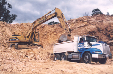
Photograph, Lakes Post Newspaper, flood response program 1998,Tambo Valley East Gippsland Victoria, 1/06/1999 12:00:00 AM
Colour photograph of Whelans truck being loaded with rock and gravel during flood response program in the Tambo Valley East Gippsland Victoriafloods, natural disasters -
 Kew Historical Society Inc
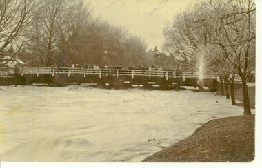
Print - Walmer Street Foot Bridge, 1901
Photographic print of the Walmer Street Bridge. The view of the Bridge is from the Abbotsford side of the Yarra. A section of pipe on the near side of the bridge is a remnant of the irrigation pipes that carried water from above Dight's falls to the Melbourne Botanic Gardens. The former bridge, constructed in 1896 was swept away in the 1901 Flood. It has two major brick piers while the remainder of the trestle supports are metal. The original photograph from which this copy was made was taken after 1901 as it shows the second bridge under construction. Houses in Young Street, Kew, can be seen on the far side of the river.Reverse: " Walmer St footbridge 1901 being repaired after flood / Constructed 1892 substantially renewed in 1901 and in 1928 / Rebuilt in 1977 by Kew Council aided by State funding. Won for designer Martin Aylard a New Zealand award presented by the timber Research & Development Assoc / Site of Simpsons Road passenger foot ferry". bridges - yarra river -- kew (vic.), walmer street bridge -- kew (vic.) -
 Marysville & District Historical Society
Photograph (item) - Black and white photographs, Unknown
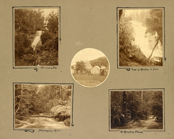
An album page with five photographs of 5 natural attractions in an around Marysville in Victoria.An album page with five photographs of 5 natural attractions in an around Marysville in Victoria.Steavenson Falls 18/ Steavenson River 21/ "Land of mountain or flood" 20/ a Mountain Stream 22steavenson falls, steavenson river, marysville, victoria, waterfalls -
 Eltham District Historical Society Inc
Photograph, Diamond Creek floods, 1953, 1953
Three photographs of floods Diamond Creek, Eltham, 21/10/1953, showing Brougham Street and Main Road near Eltham Primary Schooldiamond creek, floods, brougham street, main road -
 Bendigo Historical Society Inc.
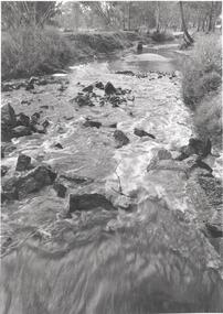
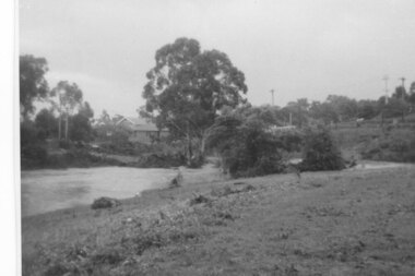
Photograph - BENDIGO ADVERTISER COLLECTION: BULLOCK CREEK LOCKWOOD SOUTH, 10/08/1993
Lockwood South Bullock Creek in flood. On rear of image Lockwood Sth 10/8/93. PART OF THE SMALL TOWNS WITH BIG HEARTS SERIESregion, small towns, lockwood south -
 Bendigo Historical Society Inc.
Slide - BENDIGO & DISTRICT P.O.I
Slide. Bendigo & District P.O.I. The Benevolent Home, opposite Tom Flood Sports Center (formerly Bendgio Show Grounds) in Barnard Street, Bendigo.slide, bendigo, bendigo & district p.o.i., bendigo & district p.o.i. -
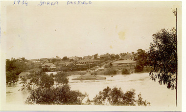 Kew Historical Society Inc
Photograph, Yarra at Fairfield, 1934 Floods, 1934
One of three digital copies of flooded areas of Kew (1923-34), donated by Jan Coutts of Bulleen in 2019. The handwriting on the originals predates the copy.1934 YARRA FAIRFIELD FROM OPPOSITE RUDDER GRANGE floods - kew - 1934 -
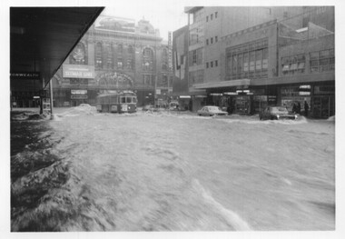 Melbourne Tram Museum
Photograph - Set of 5 black and white - Elizabeth St flood, Peter Duckett, 17-2-1972
Shows the impact of a major rain event near the Victoria Market and the former creek bed of Elizabeth Street acting as a drain. Cars floated and trams were damaged.Yields information about a major rain event in Elizabeth St during 1972 and the impact it had on vehicles and tramway operations.Set of five black and white photographs of major flooding in Elizabeth St 17-2-1972. Copied by the donor from negatives provided by the photographer.floods, elizabeth st, tramways, events, trams, melbourne -
Bendigo Historical Society Inc.
Booklet - Up the Creek and Back Again, 2014
BHS CollectionSoft cover booklet of 96 pages titled 'Up the Creek and Back Again'. The remarkable story of Carisbrook's 2011 floods and recovery. Edited by Carlene Dowie. Aerial photo of flooded township on front and back covers. Illustrated with colour photos of people and events. First published by Carisbrook Disaster Recovery Committee Inc 2014. Printed by McPherson Printing Group, Maryborough, Victoria'M&J Qualtrough' sticker on first page carisbrook, floods -
Eltham District Historical Society Inc
Photograph, Diamond Creek floods 1953, 1953
Three photographs of Diamond Creek in flood 21/10/1953 showing concrete bridge, Eltham South, Diamond Street bridge and Glen Park bridgediamond creek, floods, eltham, bridges, main road, wattletree road, diamond street, glen park -
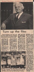 Bendigo Historical Society Inc.
Newspaper - LYDIA CHANCELLOR: TOM FLOOD
A Bendigo 'Advertiser' article titled 'Turn up the files...' and is an account of the life of Tom Flood. It includes two black and white photographs. 24/9/1969.person, bendigo, tom flood, lydia chancellor collection, collection, flood's bus service, transport, bendigo, business, trades, history, male, individual, person, photo, photograph, photos, mayor, politics -
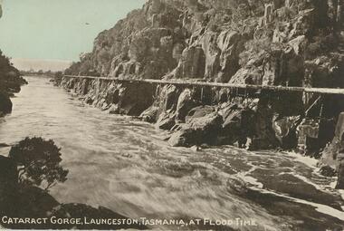 Bendigo Historical Society Inc.
Postcard - GLADYS DEAN COLLECTION: POSTCARD, 1906 - 1908
Coloured photographic postcard depicting a fast-flowing river. The words "Cataract Gorge, Launceston, Tasmania, at flood time" are printed in white at the bottom. the postcard is unaddressed.postcard, tasmania, launceston, cataract gorge -
University of Melbourne, Burnley Campus Archives
Newspaper - Newspaper Cutting, The Leader, Horticultural Notes, 1892
Copy of article in "The Leader" (Melbourne) 9 April 1892 p 10. Description of condition of Orchard after the earlier flood and finally water obtainable for irrigation.the leader, orchards, floods, irrigation, orchard -
 Clunes Museum
Photograph, HORNBY STUDIO - CLUNES, FLOOD 1909, August 1909
SEPIA PHOTOGRAPH OF SERVICE STREET BRIDGE IN CLUNES. TAKEN IN AUGUST 1909 WHEN CREEK WAS IN FLOOD. TREES ON CREEK BANK, MANY PEOPLE ARE STANDING ON BRIDGE.photographs, bridges, service street bridge -
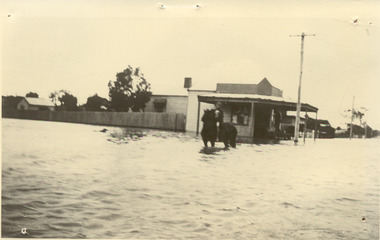 Chelsea & District Historical Society Inc
Photograph - Chelsea Flood December 1934, Corner of Sherwood Avenue and Fowler Street
In December 1934, 700 houses were inundated with water, when the Dandenong Creek and Patterson River broke their banks.Black and white photo of water inundating a shop on the corner of Sherwood Avenue and Fowler Street, Chelsea. A person is on course back riding through the flood waters.flood, chelsea, dandenong creek, fowler street, sherwood avenue -
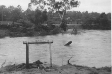
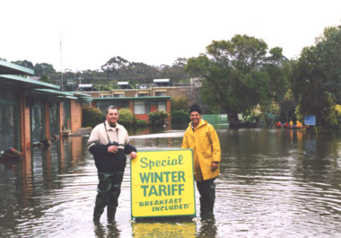 Lakes Entrance Historical Society
Photograph - floods 1998 Lakes Entrance Victoria, George Kyriakoo and Michael Pompaii at Sherwood Lodge Motel Lakes Entrance Victoria, 1/06/1998 12:00:00 AM
Colour photograph taken during floods showing George Kyriakoo and Michael Pompaii with water tariff sign at Sherwood Lodge Motel Lakes Entrance Victoriafloods, caravan parks -
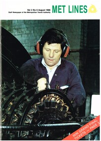 Melbourne Tram Museum
Magazine, Metropolitan Transit Authority (MTA), "Met lines - Vol. 2, No. 6", Aug. 1986
... Flooding ...Met lines - Vol. 2, No. 6, August 1986, staff newspaper of the Metropolitan Transit Authority - 20 pages, A4 size when centre stapled, printed on gloss paper. Has tramway related items on: 1 - Cover photo of fitter Saviour Axixa working on a rotary converter at Carlton substation. 2 - Doncaster Bus depot - 25 years of service 3 - The days the rains came - Elizabeth St flooding 1972 - photos by Ray Marsh 4 - Substations power tram network - article on tram substations. 5 - Tram art of a different kind - Stewart Merrett 6 - First new painted tram on line - Transporting Art by Michael Leunigtrams, tramways, transporting art, decorated trams, the met, mta, doncaster, substation, rotary converters, carlton control, elizabeth st, flooding -
 Greensborough Historical Society
Photograph - Digital image, Plenty River in flood 1972 at Rand Street crossing (3), 1972_
Plenty River in flood Greensborough 1972. There were two major floods in Greensborough at the time, 1972 and 1974. Poulter Reserve was created after the 1972 flood and had to be re-established following the 1974 flood.Digital copy of black and white photograph.plenty river, floods -
Glenelg Shire Council Cultural Collection
Photograph - Photograph reprint of scan of photograph - Casterton 1906 (Taken after flood), Victoria, n.d
Vern McCallum CollectionReprint of scan of a black and white photograph. Image is of Casterton, after the 1906 flood, taken from an elevated position. Print mounted on the white, archival mountboard frame. -
Port Melbourne Historical & Preservation Society
Photograph - Crichton Avenue flood waters, Douglas Smallpage, 1970s
B&W photos of various locations in Port Melbourne Crichton Ave flood waters. Shows four girls in bathers sitting in the water. Quinn sisters are on leftSeveral have descriptions of locations in pencil on rear of photoscrichton avenue, flood, quinn family -
 Kew Historical Society Inc
Photograph - Second Johnston Street Bridge in Flood, 1934
Original, small black and white print photograph of crowds lining the Johnston Street Bridge watching the flood waters below. The annotation on the reverse clarifies that Kew is in the distance.Annotated on reverse: "Gift of G.S. Beard / 2nd bridge / Johnston St. Studly Park Rd. Bridge looking towards Kew / 1st bridge 1858–1876, 2nd bridge built (bad bend), 1876–1958, 3rd bridge 1958, lined up Johnston St and Studley Park Rd."johnston street bridge, bridges - yarra river -- kew (vic.), flood -- 1934 -
Bendigo Symphony Orchestra Inc.
Work on paper - Sheet Music, Bartlett, Cally, Kati Thanda - Lake Eyre
Sheet Music for Kati Thanda - Lake Eyre by Cally BartlettParts printed on paper. Commissioned by the Bendigo Symphony Orchestra in 2020 this work for Symphony Orchestra tells the story of the flooding of Kati Thanda-Lake Eyre every decade.fictionSheet Music for Kati Thanda - Lake Eyre by Cally Bartlett -
 Lakes Entrance Historical Society
Photograph - Home of Fish Family, Roadknight Street Lakes Entrance Victoria, 1926 c
Also an enlarged copy of same photograph 05006.1 Built by J C Dahlsen for Vic Fish and family. Became shell museum 1960 to 70s for Mrs Newmans Camp Park named Gelia changed to Echo Beach, had various ownersBlack and white photograph of a small fibro clad house built for Vic and Myrtle Fish surrounded by receeding flood waters in Roadknight Street Lakes Entrance Victoriahouses, genealogy, floods -
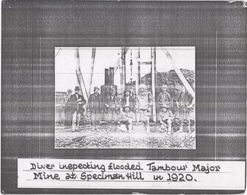 Bendigo Historical Society Inc.
Photograph - TAMBOUR MAJOR MINE - PHOTO OF DIVER
Photocopy of a photo of a diver and nine men outside the mine. The diver was inspecting the flooded Tambour Major Mine at Specimen Hill in 1920. Photo taken by Percival ?, Bendigo.photo, group, male, tambour major mine, photo of diver -
 Greensborough Historical Society
Photograph - Digital Image, Aftermath of Plenty River flood 1972 in Poulter Reserve. (4), 1972_
Plenty River in flood around the Poulter Reserve. There were two major floods in Greensborough at the time, 1972 and 1974. Poulter Reserve was created after the 1972 flood and had to be re-established following the 1974 flood.Digital copy of black and white photograph.plenty river, floods -
 Greensborough Historical Society
Photograph - Digital Image, Plenty River in flood 1972, view at the Rand Street Crossing, 1972_
Plenty River in flood at the Rand Street Crossing. There were two major floods in Greensborough at the time, 1972 and 1974. Poulter Reserve was created after the 1972 flood and had to be re-established following the 1974 flood.Digital copy of black and white photograph.plenty river, floods -
Lakes Entrance Historical Society
Book, L V Printers, Red Alert, 2007
A pictorial record of the 2006/2007 Gippsland FiresRed covered paperback with 24 pagesnon-fictionA pictorial record of the 2006/2007 Gippsland Firesfires, disasters, fundraising -
 Bendigo Historical Society Inc.
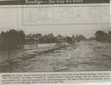
Newspaper - JENNY FOLEY COLLECTION: AWASH
Bendigo Advertiser ''The way we were'' from 2000. Awash: the Golden Square swimming pool is swamped in this photo of the flooded Bendigo Creek about 1949. The picture was taken on Maple St. looking towards Howard's Bridge, and the diving tower and springboard at the pool can be seen in the centre foreground. The date of the photo is unknown, but is believed to have been taken prior to the floods of late 1949. The clip is in a folder.newspaper, bendigo advertiser, the way we were -
Whitehorse Historical Society Inc.
Correspondence, Documents re P.E. Eriksson property purchase, 1/03/1943
Invoice and receipt - property search for Mrs P.E. Eriksson from Flood & Permezel solicitors, Collins Street. Receipt for deposit from Frank Parker, Real Estate Agent. Title check and plan from Flood & Permezel. Copy, contract of sale - Insurance Policy Coop Insurance Co. Invoice Griffiths Bros, tea merchants Nov 1910 - Jan 1911 for Mrs A. Eriksson. Advice - certificate of title.eriksson, pearl eileen, w. h. flood & permezel, frank parker (real estate agent), warnes road, mitcham no 30, land sales, cooperative insurance company of australia, edgar -
Clunes Museum
Photograph
.1 17 PHOTOGRAPHS OF CENTENARY/BACK TO CLUNES 1939 .2 PHOTOGRAPH OF SCHOOL, BAILEY STREET .3 KODAK ENVELOPE FOR PHOTOGRAPHS .4 4 PHOTOGRAPHS OF CREEK IN FLOOD.3 WRITING ON COVER RED ON BLACK: HAPPY SNAPSback to clunes, centenary 1939