Showing 362 items
matching kiln
-
 Bacchus Marsh & District Historical Society
Map, Limestone Reserve Parish of Merrimu 1888
Limestone deposits in the Coimadai area 10 kilometers north of Ballarat were first worked in the 1850s. The area was quarried for limestone for many years by various people and companies. The surveyor's name who produced this plan is inscribed on the map and below this is the name P. L. Alkemade, who presumably paid for the map to be produced. In 1886 Petrus Alkemade in partnership with Matthew Egan established the Alkemade Hydraulic Lime and Cement Company. The Alkemade family were involved in the limestone industry over several generations at Coimadai.Single page map showing part of the Limestone reserve near Coimadai in the Parish of Merrimu. Scale 4 chains to 1 inch. Part of a set of maps which are pasted into a bound volume containing 76 maps or plans in total. High resolution digital image stored on BMDHS computer network. Copy of plan surveyed by Mr. G? [illegible] an authorised surveyor on 17th July 1888. P. L. Alkemadebacchus marsh victoria maps, lime kilns coimadai, limestone, coimadai victoria maps, alkemade family coimadai -
 Phillip Island and District Historical Society Inc.
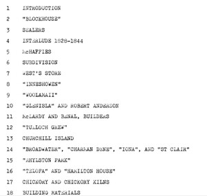
Book, EVANS, Maurice et al, An Architectural history of Phillip Island - to commemorate the centenary of open settlement on Phillip Island and Churchill Island from 1868 to 1968, 1967
RESEARCH ESSAY FOR HISTORY OF AUSTRALIAN ARCHITECTURE AND TO COMMEM0RATE THE CENTENARY OF OPEN SETTLEMENT ON PHILLIP ISLAND AND CHURCHILL ISLAND FROM 1868 TO 1968. BY MAURICE EVANS, NEIL EVANS, AND ROSALIE CARGILL, DEPARTMENT OF ARCHITECTURE, UNIVERSITY OF MELBOURNE.HistoricalStamped 'Phillip Island & District Historical Society'.phillip island, architectural history, churchill island, chicory kiln, guesthouses, houses, sealers, mchaffies, west's store, inneshowen, woolamaii, glen isla, mclardy and benal builders, tulloch grew, rhylston park, charmadene, iona, st clair, telopha, hamilton house