Showing 523 items matching " lands department"
-
 Port Melbourne Historical & Preservation Society
Plan - Port Melbourne, 1882
... Department of Lands and Surveys.... Plan Port Melbourne Department of Lands and Surveys ...Large, deteriorated 1882 plan of Port Melbourne, Parish of South Melbourne, County of Bourke - showing Town Lots. Pasted onto board.town planning, fishermans bend, sandridge lagoon, transport - railways -
Port Melbourne Historical & Preservation Society
Plan - Proposed land sub-division, west of railway, Sandridge, 19 Nov 1866
... Department of Lands and Surveys..., west of railway, Sandridge Department of Lands and Surveys ...1866 plan of proposed sub-division of land at Sandridge, west of railway. Includes manure depot.J. Noone (Photolithographer, Dept. of Lands and Survey) J. Hardy (Assistant Surveyor)town planning, town planning - proposals shelved, j noone, j hardy -
Port Melbourne Historical & Preservation Society
Photograph - Aerial view showing route of Lower Yarra Crossing Project (West Gate Bridge), Apr 1966
... Department of Lands and Survey... (West Gate Bridge) Department of Lands and Survey ...Black and white aerial photomap showing the proposed route of the Lower Yarra Crossing Project, later to become the West Gate Bridge and Freeway. April 1966'Lower Yarra Crossing Project' '296769'west gate bridge, transport - roads, engineering - bridges -
Port Melbourne Historical & Preservation Society
Map - Melbourne and suburbs, Department of Lands and Survey, 1 May 1934
... Department of Lands and Survey... sights Map Melbourne and suburbs Department of Lands and Survey ...Large printed map of Melbourne and suburbs 1936 showing historic sightsmelbourne, south melbourne, transport - tramways, transport - railways -
Port Melbourne Historical & Preservation Society
Map - City of Port Melbourne, Department of Lands and Survey, 29 Nov 1938
... Department of Lands and Survey...). 1938 Map City of Port Melbourne Department of Lands and Survey ...Printed map of City of Port Melbourne - Fishermens Bend area and down to Williamstown Road (Kitchens etc). 1938Red pencil marks through existing Lorimer St (refer 306)built environment - industrial, health - general health, fishermans bend, j kitchen & sons pty ltd -
Port Melbourne Historical & Preservation Society
Plan - Football Ground, Department of Survey & Lands, 13 May 1880
... Football Ground, Department of Survey & Lands... by Department of Survey & Lands, 1880... & Lands, 1880 Plan Football Ground, Department of Survey & Lands ...Plan for Football Ground on land being granted by Department of Survey & Lands, 1880sport - australian rules football, sport - recreational grounds, j kitchen & sons pty ltd, port melbourne football club, pmfc -
Port Melbourne Historical & Preservation Society
Letter - re Site of Sandridge Municipal Council Chambers, 5 Oct 1860
... department of lands and survey... - zoning department of lands and survey clement hodgkinson ...Handwritten letter advising of the proclamation of the site for Municipal Council Chambers at Sandridge 5th October 1860local government - municipal district of sandridge, built environment - zoning, department of lands and survey, clement hodgkinson -
 Bendigo Historical Society Inc.
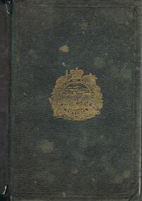
Book - DEPARTMENT OF AGRICULTURE SECOND ANNUAL REPORT 1874
Dark green cover, embossed on front 'Department of Agriculture Victoria' enclosed in circular design. Report to the Minister of Lands and Agriculture, 1874 on the proceedings of the Department, 363 pages. Written on front page in black ink "Mr H.P. Smith, Strathfieldsaye' Includes information on agricultural education, Australian grasses, diseases among stock, orange cuture, wood boring beetles, apples meteorologyof Victoria, worm diseased in sheep, sericulture, white eyebrowed woodswallow, flax, vines and wine industry, fencing and impounding. Contains information about Strathfieldsaye vigneron Messrs Bruhn and T Strachan of Axedale. Extensive metereological data for 1873 included; Sandhurst data described in depth.Variousgovernment, state, department of agriculture -
 Bendigo Historical Society Inc.
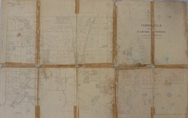
Map - JACK FLYNN MAP COLLECTION: GLADSTONE AND BENDIGO - TARNAGULLA, 13th May 1922
... . Photo-Lithographed at the Department of Lands and Survey.... Photo-Lithographed at the Department of Lands and Survey ...Map 388. Counties of Gladstone and Bendigo a Map of Tarnagulla with Kingower, Glenalbyn, Inglewood, Waanyarra and Laanecoorie boarding. The map is in poor condition and in several pieces. It has been previously taped together. The front page is of red card with white tape along the spine to hold it together, top half Tarnagulla is hand written in black lead on a label with blue trim.By Authority A.J. Mullett, Government Printer, Melbourne. Photo-Lithographed at the Department of Lands and Survey, Melbourne by W.J. Butson. 13.5.22map, bendigo, tarnagulla, tarnagulla, kingower, glenalbyn, laanecoorie, inglewood. -
Bendigo Historical Society Inc.
Document - HARRY BIGGS COLLECTION: OLD POLICE BARRACKS, 5/6/70
Document. Harry Biggs Collection. A letter on Public Works Department Victoria letterhead from G. Serpell Director General to Mr H. Biggs, Treasurer Royal Historical of Victoria (Bendigo Branch) dated 5th June 1970. In the letter he is stating The Depart. Of Crown Lands & Survey is investigating the future use & control of the old Police Barracks building.G. Serpell Director Generalorganization, club/society, community, harry biggs collection, old police barracks -
 Bendigo Historical Society Inc.
Map - JACK FLYNN COLLECTION: TARNAGULLA SHEET 4, 25/11/1926
... Photo-Lithographed at the Department of lands and Survey... at the Department of lands and Survey, Melbourne by W. J. Butson. 25.11.26 ...Map: Parish of Tarnagulla Sheet 4, Counties of Gladstone and Bendigo. Parish plan.Photo-Lithographed at the Department of lands and Survey, Melbourne by W. J. Butson. 25.11.26map, gladstone, parish plan, tarnagulla sheet 4 -
 Bendigo Historical Society Inc.
Map - JACK FLYNN COLLECTION: TARNAGULLA, 13/05/1922
... . Lithographed at the Department of Lands and Survey, Melbourne by W. J..., Government Printer, Melbourne. Lithographed at the Department ...Map: Parish of Tarnagulla . This Item is in very poor condition.By Authority, A. J. Mullen, Government Printer, Melbourne. Lithographed at the Department of Lands and Survey, Melbourne by W. J. Butsonmap, gladstone, parish plan, tarnagulla -
 Bendigo Historical Society Inc.
Map - JACK FLYNN COLLECTION: SALISBURY, 1965
... . Drawn and Reproduced at the Department of Lands and Survey... Printer, Melbourne. Drawn and Reproduced at the Department ...Map: Parish of Salisbury, County of Bendigo. Parish plan.By Authority A. C. Brooks Government Printer, Melbourne. Drawn and Reproduced at the Department of Lands and Survey, Melbourne.map, bendigo, parish plan, salisbury -
 Bendigo Historical Society Inc.
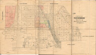
Map - JACK FLYNN COLLECTION: RAVENSWOOD, 12/12/1922
... . Photo Lithographed at the Department of lands and Survey... Printer Melbourne. Photo Lithographed at the Department of lands ...Map: Parish of Ravenswood, Counties of Bendigo and Talbot. Parish plan.By Authority A.J. Mullet Government Printer Melbourne. Photo Lithographed at the Department of lands and Survey, Melbourne by W.J. Butsonmap, bendigo, parish plan, ravenswood -
 Bendigo Historical Society Inc.
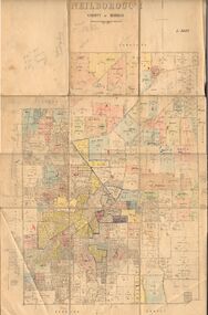
Map - JACK FLYNN COLLECTION: NEILBOROUGH, 13/10/1927
... Photo Lithographed at the Department of Lands and Survey... at the Department of Lands and Survey, Melbourne by W.J. Butson Map: Parish ...Map: Parish of Neilborough, County of Bendigo. Parish plan.Photo Lithographed at the Department of Lands and Survey, Melbourne by W.J. Butsonmap, bendigo, parish plan, neilborough -
 Bendigo Historical Society Inc.
Map - JACK FLYNN COLLECTION: MUSKERRY, 1962
... . Drawn and reproduced at the Department of Lands and Survey... Printer, Melbourne. Drawn and reproduced at the Department ...Map: Parish of Muskerry, County of Rodney. Parish plan.By Authority: A.C. Brooks, Government Printer, Melbourne. Drawn and reproduced at the Department of Lands and Survey, Melbournemap, rodney, parish plan, muskerry -
 Bendigo Historical Society Inc.
Map - JACK FLYNN COLLECTION: GIRGARRE, 1957
... . Drawn and reproduced at the Department of Lands and Survey... Printer, Melbourne. Drawn and reproduced at the Department ...Map: Township of Girgarre, Parish of Kyabram, County of Rodney. Parish plan.By Authority: W. M. Houston, Government Printer, Melbourne. Drawn and reproduced at the Department of Lands and Survey, Melbourne.map, rodney, township, girgarre -
 Bendigo Historical Society Inc.
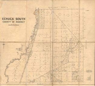
Map - JACK FLYNN COLLECTION: ECHUCA SOUTH, 13/08/1931
... By Authority H. J. Green, Govt. Printer. Department.... J. Green, Govt. Printer. Department of Lands and Survey ...Map: Parish of Echuca South, County of Rodney. Parish plan.By Authority H. J. Green, Govt. Printer. Department of Lands and Survey, Melbourne. 13.8.31map, rodney, parish plan, echuca south , county of rodney -
 Bendigo Historical Society Inc.
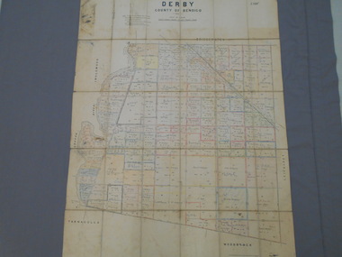
Map - JACK FLYNN COLLECTION: DERBY, 12/05/1892
... Department of Lands and Survey Melbourne by T.F.McGauran... Bendigo parish plan Derby Department of Lands and Survey Melbourne ...Map: Derby, County of Bendigo. Parish plan.Department of Lands and Survey Melbourne by T.F.McGauran, 12.5.92map, bendigo, parish plan, derby -
 Bendigo Historical Society Inc.
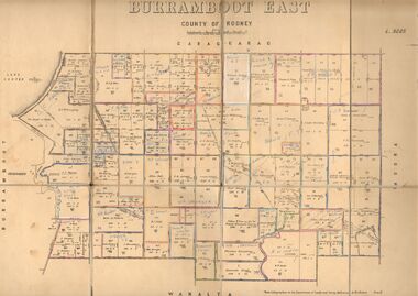
Map - JACK FLYNN COLLECTION: BURRUMBOOT EAST, 21/12/1027
... Photo Lithographed at the Department of Lands and Survey... at the Department of Lands and Survey, Melbourne by W.J.Butson. 21.12.27 Map ...Map: Burrumboot East, County of Rodney. Parish plan.Photo Lithographed at the Department of Lands and Survey, Melbourne by W.J.Butson. 21.12.27map, rodney, parish plan, burrumboot east -
 Bendigo Historical Society Inc.
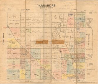
Map - JACK FLYNN COLLECTION: YARRABERB, 2/03/1931
... at the Department of lands and Survey Melbourne, 2.3.31....., Printer. Photo Lithographed at the Department of lands and Survey ...Map: Yarraberb, County of Bendigo. Parish plan.By Authority H.J. Green Govt., Printer. Photo Lithographed at the Department of lands and Survey Melbourne, 2.3.31.map, bendigo, parish plan, yarraberb -
 Bendigo Historical Society Inc.
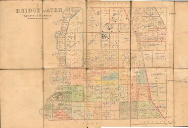
Map - JACK FLYNN COLLECTION: BRIDGEWATER, 6/10/1927
... Photo Lithographed at the Department of Lands and Survey... at the Department of Lands and Survey, Melbourne by W.J. Butson. Map ...Map: Bridgewater , County of Bendigo. Parish plan.Photo Lithographed at the Department of Lands and Survey, Melbourne by W.J. Butson.map, bendigo, parish plan, bridgewater -
 Bendigo Historical Society Inc.
Map - JACK FLYNN COLLECTION: BURNEWANG, 17/09/1918
... Melbourne. Photo Lithographed at the Department of Lands and Survey... at the Department of Lands and Survey, Melbourne by W. J. Butson. Map ...Map: Parish of Burnewang, County of Rodney. Parish plan.By Authority, H. J. Green, Acting Government Printer Melbourne. Photo Lithographed at the Department of Lands and Survey, Melbourne by W. J. Butson.map, rodney, parish plan, burnewang, rodney -
 Bendigo Historical Society Inc.
Map - JACK FLYNN COLLECTION: BONN, 16/07/1919
... . Photo Lithographed at the Department of Lands and Survey.... Government Printer, Melbourne. Photo Lithographed at the Department ...Map: Parish of Bonn, County of Rodney. Parish plan.By Authority A. J. Mullett. Government Printer, Melbourne. Photo Lithographed at the Department of Lands and Survey. Melbourne by W. J. Butson.map, rodney, parish plan, bonn, rodney -
 Bendigo Historical Society Inc.
Map - JACK FLYNN COLLECTION: VILLAGE OF BETLEY, 30/06/1874
... Photo Lithographed at the Department of Lands and Survey... at the Department of Lands and Survey Melbourne by J. Noone 30.6.74 Map ...Map: Village of Betley, on the Bet Bet Creek, Parish of Dunolly. Parish plan.Photo Lithographed at the Department of Lands and Survey Melbourne by J. Noone 30.6.74map, gladstone, village, betley, bet bet creek, dunolly -
 Bendigo Historical Society Inc.
Map - JACK FLYNN COLLECTION: BAMAWM, 19/08/1924
... Photo Lithographed at the Department of Lands and Survey... Bendigo parish plan Bamawm Photo Lithographed at the Department ...Map: Parish of Bamawm, County of Bendigo. Parish plan.Photo Lithographed at the Department of Lands and Survey, Melbourne by W.J. Butson. 19.8.24map, bendigo, parish plan, bamawm -
 Bendigo Historical Society Inc.
Map - JACK FLYNN COLLECTION: COHUNA, 1963
... . Drawn and Reproduced at the Department of Lands and Survey... at the Department of Lands and Survey, Melbourne.1963. Map: Photocopy ...Map: Photocopy of parish plan showing Cohuna and a portion of the Gunbower Creek.By Authority. A.C. Brooks Government Printer, Melbourne. Drawn and Reproduced at the Department of Lands and Survey, Melbourne.1963.map, gunbower, parish plan, cohuna , gunbower creek -
 Bendigo Historical Society Inc.
Map - JACK FLYNN COLLECTION: BET BET, 18/08/1931
... at the Department of Lands and Survey, Melbourne. 18.8.31... at the Department of Lands and Survey, Melbourne. 18.8.31 Map: Parish of Bet ...Map: Parish of Bet Bet, Counties of Gladstone and Talbot . Parish plan.By Authority H.J. Green Govt, Printer. Photo Lithographed at the Department of Lands and Survey, Melbourne. 18.8.31map, gladstone, parish plan, bet bet, counties of gladstone and talbot. -
 Bendigo Historical Society Inc.
Map - JACK FLYNN COLLECTION: KARA KARA, 1932
... . Department of Lands and Survey, Melbourne, 1958..., Government Printer Melbourne. Department of Lands and Survey ...Map: County of Kara Kara, map sheet showing the whole of the County of Kara Kara and all of the Parishes within. Scale 2 miles to 1 inch.By Authority: W.M. Houston, Government Printer Melbourne. Department of Lands and Survey, Melbourne, 1958map, kara kara, county, kara kara -
 Bendigo Historical Society Inc.
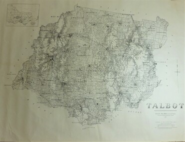
Map - JACK FLYNN COLLECTION: TALBOT, 1937
... . Department of Lands and Survey Melbourne. 1959... Printer, Melbourne. Department of Lands and Survey Melbourne. 1959 ...Map: County of Talbot, map sheet showing the whole of the County of Talbot and all of the Parishes within. Scale 2 Miles to 1 inch.By Authority: A.C. Brooks, Government Printer, Melbourne. Department of Lands and Survey Melbourne. 1959map, talbot, county, talbot