Showing 399 items matching " level crossings"
-
 Eltham District Historical Society Inc
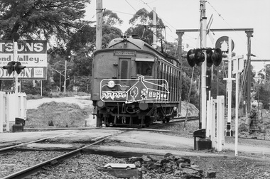
Photograph, George Coop, Hurstbridge bound Tait (Red Rattler) motor carriage passing through the level crossing at Diamond Street, Eltham, 17 July 1983, 1983
... through the level crossing at Diamond Street, Eltham, 17 July 1983...Diamond Street, Hurstbridge Line, Level Crossing, Red... melbourne Diamond Street, Hurstbridge Line, Level Crossing, Red ...Digital TIFF file Scan of 35mm Ilford FP4 black and white transparencydiamond street, hurstbridge line, level crossing, red rattler, single motor carriage, tait train -
 Eltham District Historical Society Inc
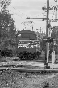
Photograph, George Coop, Hurstbridge bound Tait (Red Rattler) motor carriage passing through the level crossing at Diamond Street, Eltham, 17 July 1983, 1983
... through the level crossing at Diamond Street, Eltham, 17 July 1983...diamond street, hurstbridge line, level crossing, red... melbourne diamond street, hurstbridge line, level crossing, red ...Digital TIFF file Scan of 35mm Ilford FP4 black and white transparencydiamond street, hurstbridge line, level crossing, red rattler, single motor carriage, tait train -
 Glen Eira Historical Society
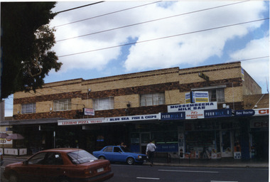
Photograph, Murrumbeena Road, 229-229A-231-231A-233, Murrumbeena, 2001
Originally labelled "Beauville Estate, Established 1936, Still Thriving 65 years on, 10th March 2001", the Beauville Estate Album contains colour photographs of houses in the Estate. They were taken around the time of the Beauville Estate’s 65th Heritage Celebration held on 10/03/2001 and donated to the Caulfield Historical Society shortly afterwards. Photographer unknown. 227 Murrumbeena Road (Bev Baxter Chemist) is not part of HO12.City of Glen Eira’s Heritage Management Plan Vol 2 p79 (this is p84 of the pdf version) – HO12 Beauville Estate and environs, Murrumbeena: The Beauville Historic Area is important at the State level as the first large housing estate undertaken by the AV Jennings Construction Co, later Jennings Group Limited, Victoria’s largest home builder. It is important also as a very early estate development incorporating a range of features other than houses and including made roads, shops and recreation facilities. In this respect it was the forerunner of the comprehensively planned housing estate of the post war era. The estate is distinguished by its aesthetic values, as is the earlier and comparable Hillcrest Estate, which are formed by a combination of restrained diversity in house styles, with the exception of no. 30 in the emerging International style, and by a landscaped garden environment. Colour photograph of a group of commercial properties with ground level shops and upper level two toned brown, unpainted brick residences. The photograph taken from across the road also includes parked cars, a person leaning on a car outside the fish and chip shop and a pedestrian crossing the road. Shops shown are from left to right: Cafe Fresca, 231 Hair Creations, Leovorno Pizza, Blue Sea Fish & Chips, Murrembeena (sic) Milk Bar and a portion of the one storey shop Bev Baxter Chemist at the right end. LEOVORNO PIZZA / BLUE SEA FISH & CHIP / Herald Sun / Sunday / MURREMBEENA MILK BAR / PK's / SANDWICH BAR / Bev Baxtermurrumbeena, architectural styles, 1930's, inter war style, a.v. jennings, av jennings, jennings, beauville estate, murrumbeena road, commercial establishments, shops, pharmacies, milk bars, fish shops, sir albert victor jennings, a v jennings construction co, beauville estate heritage area, glen eira city council, architectural features, jennings group limited, land subdivision, beauville historic area, brick shops, brick features, hairdressers, pizza shops, restaurants -
 Glen Eira Historical Society
Document - NEERIM ROAD RAILWAY CROSSING AND GATES GLEN HUNTLY
This file contains two items: 1/Twelve photographs of the Glen Huntly, Neerim Road hand-operated railway gates, dated 1983 and November 1985, photographer unknown, and two black and white copies of two of the original photographs. Four photographs are in black and white and eight are in colour, all picturing the Gatekeeper’s shelter and/or the railway gates. Six photographs dated 1985 include the Gatekeeper, unidentified, in some photos operating the gates. 2/A three-page pamphlet dated 03/05/1979 promoting a public meeting at the Caulfield Town Hall to debate Road Grade Separation proposals for the Neerim Road and Glenhuntly Road railway crossings. Document details the proposed VicRail improvement and four alternative improvements as we as a blank questionnaire for the submission of ideas regarding the proposals to the Caulfield City Council Urban Planner. A short summary of other concerns held by two councillors and an engineer regarding the proposal is also included, as is a Railway Noise Level. Railway Pamphlet also includes a map of the area surrounding the railway crossings under discussion 1977.glenhuntly road, neerim road, caulfield, railway gates, gates, hand-operated railway gates, railways, roads and streets, railway crossings, architectural features, town halls, official buildings, vicrail, meetings, public meetings, caulfield town hall, gatekeepers, caulfield city council, elsternwick, glen huntly, caulfield park, caulfield racecourse, normanby road, dandenong road, railway buildings, railway stations, land transport, transport establishments, hordern a.g., dunstan don, hordern bill, needham j.g., advertisements, graphics, advertising, advertising signs, signs, estate agents, business people, stockdale and leggo, buildings structures and establishments, occupations, united signs, signs, communication devices, motor vehicles, glenhuntly railway station, town planning, civic and landscape art, engineers, professionals, traffic, road transport, transport, maps, documents, plans -
 St Kilda Historical Society
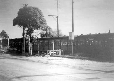
Photograph, Elsternwick Station with level crossing, c. 1958
... Elsternwick Station with level crossing... laminated Elsternwick Station with level crossing Photograph ...black and white photograph laminatedElsternwick Station with crossing gates beforethe bridge was built in 1958 tram, destination Point Ormond.The Rex. The Sun -
 Sunshine and District Historical Society Incorporated
Photographs (1928), 'QUARTER MILE' BRIDGE Construction, 1928
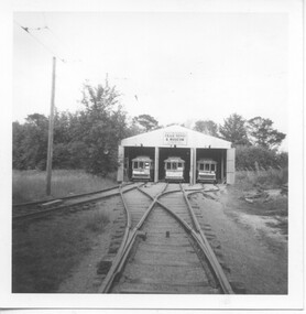
One man lost his life during the building of this bridge. The bridge was constructed by the Victorian Railways between 1927 to 1929 to carry a new double track goods line. This enabled trains from all parts of the state except Gippsland to have direct access to the Tottenham marshalling and sorting yards. These yards were constructed in the 1920's to relieve congestion in the Melbourne Yard near Spencer Street station. The congestion was being caused by the construction of suburban passenger platforms associated with the electrification of the suburban railway network. Initially the bridge was for goods trains but during the Second World War it was also used by troop trains. When the standard gauge line was built in 1962 all trains to Albury and Sydney have used this route, thus avoiding travelling through Essendon and Pascoe Vale on the suburban tracks. The standard gauge track across the bridge took the place of one of the broad gauge tracks so broad gauge trains crossing the bridge in either direction have to now use the same track. The bridge is 1,257 feet (383.13 metres) long and 180 feet (54.86 metres) above the water level. It is just 63 feet (19.2 metres) short of a quarter mile in length between abutments. There is a similar bridge on the same railway line crossing the Moonee Ponds Creek between Gowenbrae and Glenroy, however it is smaller at 1060 feet (323.08 metres) length and 115 feet (35.05) height.The bridge is now Victorian Heritage Registered under Number: H1197, and Heritage Overlay Numbers HO5, and HO107. On the Heritage Register it is named RAIL BRIDGE (ALBION VIADUCT). According to the Heritage Report the bridge is scientifically and architecturally important because of its large size, and because of the cost effective design features such as two girders per span (one for each track), the K bracing in the towers, and the broad flange beams as columns. When it was being built it was the largest trestle bridge in Australia, and until the Sydney Harbour bridge was constructed it was the highest railway bridge.Five B&W yellowing photos showing stages of construction of the Maribyrnong River Viaduct known as the Trestle Bridge but mainly known locally as the QUARTER MILE BRIDGE. It is a railway only bridge which runs over the Maribyrnong River between Sunshine North and Keilor East. A sixth image, which is not part of this set of photos, is included to show what the completed bridge looks like. -
 Nillumbik Historical Society Incorporated
Photograph - Black & white photograph, Diamond Creek Railway Crossing c1920
... Hoodoo Level Crossing... Square Diamond Creek melbourne Railway Crossing Hoodoo Level ...Black & white photographrailway crossing, hoodoo level crossing, diamond creek, nillumbik -
 Whitehorse Historical Society Inc.
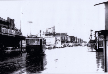
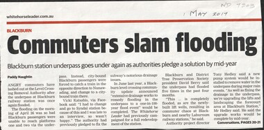
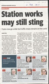
Article, Commuters slam flooding, 2017
... level crossing removal authority... Mitcham melbourne level crossing removal authority blackburn ...The underpass at Blackburn railway station flooded again on the morning of Apr 26th preventing passengers from boarding city bound trains. This is the fifth time it has flooded in the past 4 months.level crossing removal authority, blackburn railway station -
 Whitehorse Historical Society Inc.
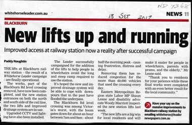
Article, Blackburn Station LIfts, 2017
... Level Crossing Removal Authority... and CCTV. Blackburn Railway Station Level Crossing Removal ...The two lifts and improved drainage system at Blackburn Railway Station.The two lifts and improved drainage system at Blackburn Railway Station are now functional along with upgraded lighting and CCTV.The two lifts and improved drainage system at Blackburn Railway Station. blackburn railway station, level crossing removal authority -
 Whitehorse Historical Society Inc.
Article, Public Loo Finally Opens, 2018
... level crossing removal authority... Mitcham melbourne public utilities toilet block disabled level ...A Disabled Toilet at Blackburn Railway Station is finally open for use.public utilities, toilet block, disabled, level crossing removal authority, blackburn railway station -
 Whitehorse Historical Society Inc.
Article, Path Sparks Disagreements, 2016
... Level Crossing Removal Authority... Mitcham melbourne Level Crossing Removal Authority Berry David ...Cyclists are concerned the negative commentary surrounding the southern alignment of the shared-use bike path through Blackburn is unwarranted and will give them a bad name.Cyclists are concerned the negative commentary surrounding the southern alignment of the shared-use bike path through Blackburn is unwarranted and will give them a bad name.Cyclists are concerned the negative commentary surrounding the southern alignment of the shared-use bike path through Blackburn is unwarranted and will give them a bad name.level crossing removal authority, berry, david, cycling, blackburn -
Whitehorse Historical Society Inc.
Article, New Path proposal Put Forward, 2016
... Level Crossing Removal Authority... is better. Blackburn Level Crossing Removal Authority Cycling ...VicRoads has decided that the shared-use path will be located south of the railway line at Blackburn.VicRoads has decided that the shared-use path will be located south of the railway line at Blackburn. However Box Hill North's Peter Carter, a former VicRoads traffic engineer, believes his northern alignment is better.VicRoads has decided that the shared-use path will be located south of the railway line at Blackburn. blackburn, level crossing removal authority, cycling, vicroads, carter, peter -
Whitehorse Historical Society Inc.
Document, Removal of Trees, 2016
... Level Crossing Removal Authority... Mitcham melbourne Blackburn Level Crossing Removal Authority Trees ...The fate of backyard trees bordering the rail line boundary in Blackburn may rest in the hands of the residents.The fate of backyard trees bordering the rail line boundary in Blackburn may rest in the hands of the residents.The fate of backyard trees bordering the rail line boundary in Blackburn may rest in the hands of the residents.blackburn, level crossing removal authority, trees -
 Whitehorse Historical Society Inc.
Article, Blackburn Level Crossing, 2017
... Blackburn Level Crossing...level crossing removal authority... Mitcham melbourne level crossing removal authority blackburn ...Trains now travel under Blackburn Road but further construction work could require further closures to Blackburn Road later this year.level crossing removal authority, blackburn, blackburn road -
 Whitehorse Historical Society Inc.
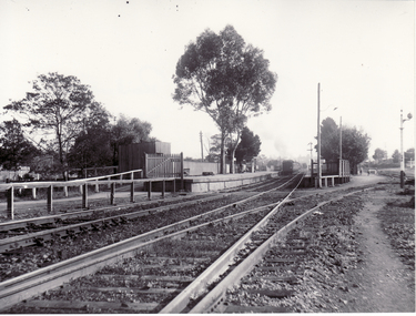
Photograph, Blackburn Railway Station - Looking West from Level Crossing - 1919, c1919
... Blackburn Railway Station - Looking West from Level... Station - Looking West from Level Crossing - 1919 Photograph ...Black & white photo of Blackburn Railway Station in 1919blackburn railway station, 1919 -
 Ballarat Tramway Museum
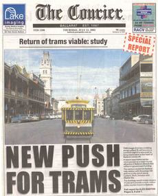
Newspaper, The Courier Ballarat, "Return of trams viable study", "New Push for Trams", "Taking tourism to the next level", "More tourists, more jobs expected", "Tram plan worthy of expected debate", 11/07/2002 12:00:00 AM
Set of three cuttings from The Courier, Ballarat dated Thursday 11/7/2002 regarding the reintroduction of trams to Ballarat. 2241.1 - Page 1 and 2 of The Courier, with page 1 titled "Return of trams viable study" and "New Push for Trams" as the commencement of a Special report showing a digitally constructed image of No. 13 in Lydiard St. North. Note the tram does not have a driver. Introduces reports by Alex Easton on pages 2, 6 and 7. On Page 2, titled "Taking tourism to the next level", has details of the Council viewpoints on the proposal, public consultation, a map of the route, and notes on the construction issues. Has a digital image of 13 crossing Sturt St. into Lydiard St. North. See images No. 1 to 3. 2241.2 - page 6 of The Courier, which joins with page 7 using the titled "More tourists, more jobs expected". Has Sections reviewing the study outcomes, benefits and a summary of the study. Page 6 has a photo of a passenger boarding No. 21, decorated as the Myers Christmas tram in Sturt St and a photo of Bridge St. in 1971 (very poor quality reproduction). See images No. 4 and 5. 2241.3 - page 7 of The Courier, has Sections detailing the history of Ballarat Trams, proposals for the City Tramway, costs, consultation, and comments from Peter Hiscock. Has a photo of Peter Hiscock and Mayor David Vendy in front of No. 13 at the BTM depot. See image No. 6. Also has a photo of Dianne Smith, Executive Director of Ballarat Tourism. On page 8, as part of The Courier's editorial Section, has comments on the proposals, titled "Tram plan worth of extended debate". Looks at the $20million cost. ballarat revival, editorial, ballarat city tramway, lydiard st. nth -
 Ballarat Tramway Museum
Photograph - Black & White Photograph/s - set of 3, Dave Macartney, 23/12/1967 12:00:00 AM
... the Ballarat level crossing. Trams Tramways Ballarat Bridge St. Traders ...Yields information about decorated trams, Bridge St traders Christmas tram and the area near the Ballarat level crossing.Black and white photograph of SEC Ballarat No. 17 about to cross the railway lines in Lydiard St. North. Has destination of "SEBASTOPOL". Tram decorated for Bridge St. Traders and has been painted white, except for warning stripes on front of tramcar. Sign on front says "BRIDGE ST TRADERS/SEASON GREETINGS". Photo taken 23/12/1967. 583.1 - as above but a wider view to the right, showing Kennedy Murray Pty Ltd, General Carriers buildings in the railway yard and part of the railway goods shed. .2 - as for .2.2 - has stamp on back "Ronald and Jennifer Burzacott, 22 Howard St, Sebastopol Vic 3356"trams, tramways, ballarat, bridge st. traders, lydiard st. north, christmas trams, railway , tram 17 -
 Ballarat Tramway Museum
Slide - 35mm slide/s, Carolyn Dean, 3/11/1970 12:00:00 AM
Shows a special tram operating on the View Point line, which was not regularly used and difficult to get a tram along the line at the time. Almost not used at all prior to closure. Shows crossing on a curve of Mair St and the way the road level was built up - dates from horse tram days.Kodak slide, white cardboard of No. 21 operating a special on the View Point Ballarat line. Taken 3.11.1970 by Carolyn Dean. Tram about to cross Mair St. Shows how this section of tram line was higher than the general road level of Mair St. at this point. Tram has the destination of View Point . ."3-11-70" in ink on slide.tramways, trams, ballarat, view point, ripon st, mair st, tram 21 -
 Ballarat Tramway Museum
Photograph - Black & White Photograph/s, Ron Hann, Jan. 1963
... the North Bendigo terminus, the level crossing and roof ...Yields information about the North Bendigo terminus, the level crossing and roof advertisements on the tramcar.Black and white print on heavy matt photographic paper of Bendigo 19 at the North Bendigo terminus, with the conductor walking back to the tram, c1963. The tram has an "Electric Cook" roof advertisement and "Cohns Drinks" advertisement on the front dash panel. 2nd copy - laser print - with date etc on rear - added 22/2/2010, copy from Ron Hann. Printed on Fujifilm, Fujicolour Crystal Archive for Frontier"On rear in pencil "North Bendigo 1963" 2nd copy has label "Reference 6/212/30" Photo by Ron Hann" and another label "Bendigo North 01.63"tramways, trams, bendigo, north bendigo, tram 19 -
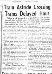 Ballarat Tramway Museum
Document - Photocopy, Alan Bradley, "Train Astride Crossing Trams Delayed Hour", 2003
... St Level crossing, how it was overcome. Also gives ...Yields information about the operation of the tram system when a delayed occurred at the Lydiard St Level crossing, how it was overcome. Also gives information about the Councils view of the level crossing itself.Photocopy, of an item in the Ballarat Courier, 5/5/1951 titled "Train Astride Crossing Trams Delayed Hour", following the delay in the crossing when a rail broke under a goods train. Held up trams and others for about an hour and half. Notes the SEC used a replacement bus service. Gave the City of Ballaarat space to complain about the crossing and its need to be replaced. Quotes the Town Clerk, Mr, Maddern.trams, tramways, railway crossing, lydiard st nth, railways, city of ballarat -
 Ballarat Tramway Museum
Slide - 35mm slide/s, Glen Mills, Sept. 1971
White cardboard mount, 35mm slide, from the Association of Railway Enthusiast's film strip titled "Provincial Tramway Film Strip" of No. 38, crossing Albert St, southbound, with Destination of Sebastopol. Photo taken after tram has passed photographer. Has the Anglican Trinity church in the background. The film strip notes (Reg. Item 2560), provided the following caption details: "About 1/2 mile from the terminus the line crossed to the west side of the road. Here car No. 38 outbound bowls across the asphalt. - Nov. ' 70 (Glen Mills)" See image btm2576p.tif for high level scan of image. Stamped on base of slide "11786" and written in ink on top edge "No. 38 Sebastopol line Ballarat"tramways, trams, are, film strip, albert st, sebastopol, tram 38 -
 Ballarat Tramway Museum
Slide - 35mm slide/s, Glen Mills, Sept. 1971
White cardboard mount, 35mm slide, from the Association of Railway Enthusiast's film strip titled "Provincial Tramway Film Strip" of a bogie tram on the reserved track between Ophir St and the terminus - telephoto lens. Note tram stop signs, aerial phone lines, the condition of the track and the gravel crossings. The film strip notes (Reg. Item 2560), provided the following caption details: "Years of neglect of trackage shows up here near Sebastopol as a bogie car approaches in the distance. - Sept '71 (Graham Evans)" See image btm2577p.tif for high level scan of image. Stamped on base of slide "11787" and written in ink on top edge "Sebastopol line"tramways, trams, are, film strip, albert st, sebastopol, tram 38 -
 Ballarat Tramway Museum
Document - Folder with papers, State Electricity Commission of Victoria (SECV), 1930's
Yields information about how the SEC filed pamphlets or information papers about tramway overhead and associated equipment and letters.Green cardboard file folder with metal clip and binder - "The Acorn Individual File - Foolscap size with title blocks containing the following items: 4910 - Tangential Suspension - overhead 4911.1 - Letter from "The Forest City Electric Co. Limited" to ESCo re Point controllers, tramway signals and warning signs, dated 29/7/1936 - 2 pages 4911.2 - Collins Patent Automatic Point Turner - sheet 19 - 4 pages - sheet 19, two copies 4911.2a - ditto, sheet 18 QT - four pages 4911.3 - Electrically operated Point switches, overhead frogs and signals for tramcar depots. - four pages 4911.4 - Automatic Tramway Signals - five pages - sheet ATS1 4911.5 - Universal Insulator - Sheet 17 - 2 pages 4911.6 - Porcelain hangers - sheet 15/1 - 2 pages 4911.7 - Porcelain insulators for cap and cone supension - page 11, 1 page. 4911.8 - Motor Bus and Tramcar Stage and Fare Signs in Cast Aluminium - sheet MD2 - 1 page 4911.9 - Flashers and Spellers - Sheet F1 - 2 pages 4911.10 - Forest City Relays - 2 pages 4911.11 - Traffic light - 1 page, sheet 2A 4912 - Memo re Suitability of Mr A. Widdop as a linesman - 18/11/1936 4913.1 - Letter dated 22/6/1937 from Agent General in London to the SEC Melbourne regarding shipment of the Non-Car Counting Signals. 4913.2 - Letter from the Forest City Electric Co 18/6/1937, regarding forwarding a blue print for the signals. 4914 - Letter from the Forest City Electric Co 23/6/1937, regarding forwarding sample insulators and booklet 15.2 4915 - Letter from Sands Hill Manufacturing Co to ESCo re regarding overhead crossings - dated 13/4/1928. 4916 - Memo dated 14/3/1934 to Mr Pringle, regarding tension in trolley wire. 4917 - Letter from T. Strickland MMTB to Bendigo re standard height for ears above rail level - 16/3/1934. Some of these document Scanned in pdf form to COTMA Library 1/2011 On rear of file: Top of file - "Tramways", in title block "Tramway Overhead & Signals" and in bottom right hand corner - "230". On spine - in pencil - "Overhead Parts and Proceedings"trams, tramways, signals, overhead, pamphlets, manual -
 Ballarat Tramway Museum
Photograph - Black & White Photograph/s, Doug Colquhoun, 15/04/1955 12:00:00 AM
... at the Ballarat Railway station and level crossing. trams tramways Geelong ...Yields information about Ballarat's trams in the early 1960's and the street scape at the Ballarat Railway station and level crossing.Black and white print of Geelong No. 5 - side view, Ryrie St, 15/4/1955, by Doug Colquhoun. Two copies. Photo print courtesy of Port Dock Railway Museum, now the National Railway Museum. See worksheet 4311 for letter and details of prints sent to Bill Scott, 19/10/2001. Any photo credit to mention NRM Collection.On rear of copy 1 "SEC Geelong / 5 / Ryrie St / 15/4/55 2141 / D A Colquhoun " Copy 2 "Ryrie St? going E / D. Colquhoun" in ink, bottom right hand corner.trams, tramways, geelong, ryrie st, tram 5 -
 Ballarat Tramway Museum
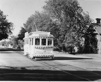
Postcard, Ron Scholten, SEC Ballarat tram 17
... the use of Special trams and the Ballarat railway station level ...Yields information about the use of Special trams and the Ballarat railway station level crossing.Colour photograph, printed on a postcard back format of SEC Ballarat tram 17 crossing Sturt St from Lydiard St north with the Ballarat Post Office in the background. Doors have been changed over for the Sturt St central median strip. Note the lady with the walking stick behind the tram and the tram stop sign. Tram has an SEC Electric Cooking advertisement and the destination of Bell St.trams, tramways, lydiard st north, sturt st, post office, tram 26 -
 Ballarat Tramway Museum
Photograph - Black & White Photograph/s, late 1973
... Ormond line and the reconstruction of the Glenhuntly Road level ...Yields information about the appearance of BTM tram No. 661 in 1960, the use of X2 on the Point Ormond line and the reconstruction of the Glenhuntly Road level crossing at Elsternwick during 1960. Black and white photographs of the depot fan late 1973 showing progress in ballasting the fan and area being cleaned up. Three trams in the depot with doors open. Agfa paper with date stamp "?.12.73" trams, tramways, depot fan, btps, operations, trackwork -
Kew Historical Society Inc
Journal, Kewriosity : April 1991
... [accessible toilets at Senior Citizens' Centre] / p5. [Level] Crossing ...Still delivering the goods [Kew Post Office] / p1. Grand Parade [photos Kew Festival] / p1. Dates for April / p2. Heritage Advisor [Heritage Advisory Service] / p2. Council Voter's Roll / p2. Nobody does it better [The Fabulous Nobody Theatre Company present 'Joseph and His Amazing Technicolour Dream Coat'] / p2. Commentary [Commercial Area Strategy Plan] / Cr Daryl Oldaker p3. Traffic School appointment [Marion Burg] / p3. Recycling trial [120 litre mobile recycle bins] / p4. Enlarging [large print] book collection [Kew Library] / p4. Bin gardening lately [composting] / p4. Alex Jessup [death] / p4. Roads desire [road reconstruction and maintenance] / p5. No alcohol at this AGM [People Against Drink Driving (PADD)] p5. Recreation Centre investment [works] / p5. Breathe easily / p5. RSL milestone [75th anniversary] / p5. New look City Hall [re-carpeting] / p5. Kewrious to know [Council surveys] / p5. Senior Citizens' Week / p5. Senior Citizens' good deed [accessible toilets at Senior Citizens' Centre] / p5. [Level] Crossing supervisor / p5. Wizz, chief cook, and ... [Joe Wormald, 1991 Citizen of the Year] / p6. Historic buildings [12 Uvadale Grove] / p6. Spiritual offerings [Rotary Club of Kew Art Competition] / p6. History of Kew Library / p6. Cab & Co [Citizens Advice Bureau] / p6. Music in [the] Round returns [Chamber music festival] / p7. Inspect Strathcona / p7. Date of Census / p7. Brasses and basses wanted [Kew Philharmonic Society] / p7. Kinder turning 40 [J.J. McMahon Memorial Kindergarten] / p7. Plate replacement [Neighbourhood Watch plates] / p7. The Devil's Advocate [unrateable properties] / Allan Hutchinson J.P. p8. Do festivals divert attention? / p8.Kewriosity was a local newsletter combining Kew Council and community news. It was published between November 1983 and June 1994, replacing an earlier Kewriosity [broad] Sheet (1979-84). In producing Kewriosity, Council aimed to provide a range of interesting and informative articles covering its deliberations and decision making, together with items of general interest and importance to the Kew community and information not generally available through daily media outlets.non-fictionStill delivering the goods [Kew Post Office] / p1. Grand Parade [photos Kew Festival] / p1. Dates for April / p2. Heritage Advisor [Heritage Advisory Service] / p2. Council Voter's Roll / p2. Nobody does it better [The Fabulous Nobody Theatre Company present 'Joseph and His Amazing Technicolour Dream Coat'] / p2. Commentary [Commercial Area Strategy Plan] / Cr Daryl Oldaker p3. Traffic School appointment [Marion Burg] / p3. Recycling trial [120 litre mobile recycle bins] / p4. Enlarging [large print] book collection [Kew Library] / p4. Bin gardening lately [composting] / p4. Alex Jessup [death] / p4. Roads desire [road reconstruction and maintenance] / p5. No alcohol at this AGM [People Against Drink Driving (PADD)] p5. Recreation Centre investment [works] / p5. Breathe easily / p5. RSL milestone [75th anniversary] / p5. New look City Hall [re-carpeting] / p5. Kewrious to know [Council surveys] / p5. Senior Citizens' Week / p5. Senior Citizens' good deed [accessible toilets at Senior Citizens' Centre] / p5. [Level] Crossing supervisor / p5. Wizz, chief cook, and ... [Joe Wormald, 1991 Citizen of the Year] / p6. Historic buildings [12 Uvadale Grove] / p6. Spiritual offerings [Rotary Club of Kew Art Competition] / p6. History of Kew Library / p6. Cab & Co [Citizens Advice Bureau] / p6. Music in [the] Round returns [Chamber music festival] / p7. Inspect Strathcona / p7. Date of Census / p7. Brasses and basses wanted [Kew Philharmonic Society] / p7. Kinder turning 40 [J.J. McMahon Memorial Kindergarten] / p7. Plate replacement [Neighbourhood Watch plates] / p7. The Devil's Advocate [unrateable properties] / Allan Hutchinson J.P. p8. Do festivals divert attention? / p8. publications -- city of kew (vic.), kewriosity, council newsletters, community newsletters -
 Surrey Hills Historical Society Collection
Photograph - Black and White Photograph, Last train to cross the grade level crossing at Elgar Road
... Last train to cross the grade level crossing at Elgar Road... the grade level crossing at Elgar Road Photograph Black and White ...The last swing door train was withdrawn from service in 1973. The third track on this line was commissioned in 1971. The overpass bridge was built at this time. These dates place the photo as pre-1971. More research needed.A black and white photo taken from street view of a swing door train crossing a roadway with a simple boom gate barrier. The bonnet of a car can be seen at the LHS of the photo.elgar road, trains, alfred noack, boom gates, swing door trains -
 Sunbury Family History and Heritage Society Inc.
Photograph, Bulla, C 1980s
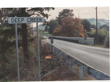
The photograph shows the approach to the Bulla Bridge at Deep Creek in the Township of Bulla. Immediately on crossing the bridge there is a sharp bend in the road and a step ascent up Bulla Hill through the cutting until level ground is reached. The photograph is looking to the NW. Deep Creek meets the Maribyrong River further downstream and closer to Keilor.The bridge and road replaced the ford crossing in 1869 that was downstream from the bridge.A coloured photograph of the approach to a bridge over the Deep Creek at Bulla along Sunbury Road. bulla bridge, deep creek, sunbury road -
 City of Kingston
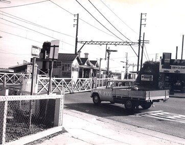
Photograph - Black and white, c. 1960
... Level crossing... and traffic waiting. Highett City of Kingston Level crossing Railway ...Highett railway station with crossing gates closed and traffic waiting.Black and white photograph of Highett railway gates. Gates are closed and a ute is waiting at the crossing.Stamped on reverse: COPYRIGHT / Public Transport Corporation / For re-ordering photographs / Please quote negative No H3985 / Enquiries C/- PIC Photographic Unit / Telephone switchboard 519 1111highett, city of kingston, level crossing, railway station