Showing 2345 items matching " mountains"
-
 Whitehorse Historical Society Inc.
Article, Bikers jump at chance to test new track, 2005
Article on the new mountain bike circuit at East Burwood Reserve.Article on the new mountain bike circuit at East Burwood Reserve. With photo of 'Simon', 11, riding the track.Article on the new mountain bike circuit at East Burwood Reserve.east burwood reserve, cycling, bicycle paths -
 Ballarat Heritage Services
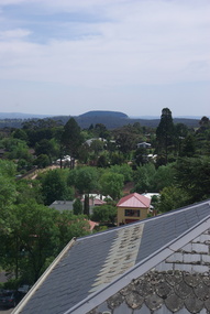
Photograph - Photograph - Colour, Mount Franklin from the Convent Gallery, Daylesford, 2015, 25/10/2015
The Convent Gallery was formerly Holy Cross Convent, and incorporates the Gold Commissioners house. An extinct volcanic mountain is seen in the distance. The slate roof of the former Holy Cross Convent in Daylesford is in the foreground. holy cross convent, presentation convent, convent gallery daylesford, slate roof, mount franklin, volcano, lalgambook -
 Brimbank City Council Art Collection
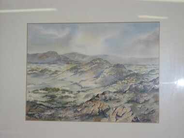
Painting, Beyond the You Yangs
Local Scene, Artwork was entered into an art prize. It is unknown which one. Bruce Cooper. Beyond the You Yangs. Watercolour, 26 x 35cm, overlooking the mountain range - AR0059 -
 City of Greater Geelong
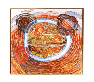
Acrylic on Canvas, Big Day Out, 2010-2011
Rohan Robinson is an artist born in Geelong, and attended “the Mill” part of Deakin University in 1980-82, studying Fine Art. In 2010-11, he was the manager of Kayili Artists Aboriginal Corporation, at Patjarr in the Gibson Desert W.A., where he oversaw the development and marketing of artworks of the corporation’s members. The community is the remotest in Australia and averaged 25 people, mostly consisting of elderly people and part of the Ngaanyatjarra region, with some members not having any consistent contact with white fellas up to the mid 1960’s. During his time it was common for all the community members to go out hunting and having a visit to important areas, where members would get some tucker of rabbits and lizards and honey ants and perhaps some “meow meow” and have a nice sleep in the shade on the warm sand. Robinson would often take his painting gear along and do some work on unstretched linen on the desert ground, he would paint for a while and then perhaps lie around with the elders or follow one of the expert hunters and observe from a distance [several meters] the skills of elderly women casually walking through some recently burned spinifex knocking cowering bunnies on the head with a steel rod. It was on one of these occasions, when this particular painting was being conceived, that after returning from the hunting mission, he was informed by some of the mob, that an elder had been spending time looking at this work in it’s infantile stage...”You know the old fella over there, he been looking at that painting of yours” It was later in the day, when returning to Patjarr, that the elder Arthur Robertson approached Robinson, and demanded/asked that Robinson paint his stories for him. Mr Robertson was suffering from Parkinson’s disease, and was having trouble painting, but had been doing some brilliant work with Posca markers. It was with a certain reluctance that Robinson agreed, as he felt this to be a “political hot potato in some quarters” but also respected a relationship between artists beyond the cultural divide. Mr Robertson demanded that they start immediately and armed with pencil and paper they created the notes for several paintings under Mr Robertson’s direction. The painting that you are viewing is signifcant in that it was the catalyst for this relationship between the two artists. Mr Arthur Robertson died later that year 2011.Gold framed blue and earth tone painting. Painting depicting four circles with mountain and sky in the background. -
Moorabbin Air Museum
Book - The Sikorsky S-38 Flying Boat, P.J. Capelotti et al
A comprehensive story of the Sikorsky S-38 Flying Boat, with photography and maps.A beige book with an illustration of a S-38 flying past a mountain over water, and photo of a replica on the back.A comprehensive story of the Sikorsky S-38 Flying Boat, with photography and maps.sikorsky s-38 flying boat -
 Stawell Historical Society Inc
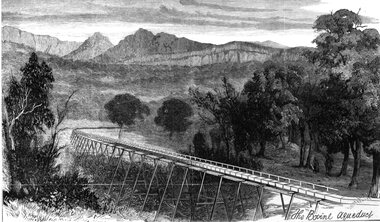
Drawing, Stawell Water Supply Bovine Aqueduct 1881 -- Sketch
Sketches of Stawell Water Supply Bovine Aqueduct October 5th 1881. The Grampian scheme planned by the the Borough Engineer John D'Alton. D'Alton's suggestion was that the water be carried from the source in an open channel two miles, then in a flume of timber. Later surveyed and planned a tunnel on a good line - to reduce the flume 72 miles and the main to Stawell to 15 miles. This sketch (illustrated Australian News October 5, 1881).Black and white photograph of a sketch a bush scene with mountains in background. The sketch depicts a trestle bridge construction. The Bovine Aqueduct stawell water supply -
Stawell Historical Society Inc
Painting, Will Rees, Bush Scene, 1930's
Bush scene with path and mountains in background, probably Grampians. Gum tree in right of painting. Oil on PaperWill J Rees David Morcom 29/8/1987 on back -
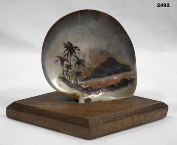 Bendigo Military Museum
Memorabilia - TRENCH ART, SOUVENIR SHELL, 1947
On display label: “Hand Painted Shell. Made in the islands WW2. Donated by N Hubble.Hand painted shell souvenir with palm trees, mountain. Shell mounted on timber stand, diamond shape.On timber base - hand inscribed - “N/Horvic Hubble/1947/WW2”military history, souvenirs, islands -
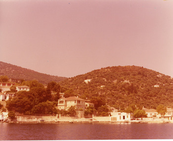 Ithacan Historical Society
Photograph, Kioni, Ithaca, c1970s
The photograph is a view of the harbour of the village of KIoni in northern Ithaca. Many Ithacans who migrated to Melbourne were from the village of Kioni. Kioni is considered one of the most picturesque villages in Ithaca.A coloured photograph of a view of a harbour village . Houses are built along the water's edge and mountains form a backdrop.villages, kioni -
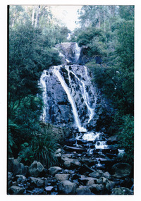
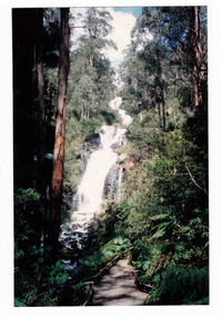 Marysville & District Historical Society
Photograph (item) - Colour photograph, 1992
A colour photograph of Steavenson Falls in Marysville in Victoria.A colour photograph of Steavenson Falls in Marysville in Victoria. The Steavenson Falls is named after the Victorian Assistant Commissioner of Roads and Bridges, John Steavenson who arrived in Victoria in the early 1860s.Nov. 1992 Stevensons Fallssteavenson falls, waterfalls, marysville, victoria, john steavenson -
 Marysville & District Historical Society
Photograph (item) - Colour photograph, Pre 2009
A colour photograph of Steavenson Falls in Marysville in Victoria.A colour photograph of Steavenson Falls in Marysville in Victoria. The photograph shows the viewing platform that was destroyed in the 2009 Black Saturday bushfires. The Steavenson Falls is named after the Victorian Assistant Commissioner of Roads and Bridges, John Steavenson who arrived in Victoria in the early 1860s.steavenson falls, waterfalls, marysville, victoria, john steavenson, 2009 black saturday bushfires -
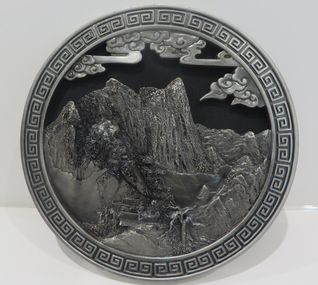 Federation University Historical Collection
Object - Plaque, Round pewter plaque from China
Round pewter 3 dimensional plaque depicting a mountain scene from China, with a square swirl patterned border.Small oval sticker that says Carbon Carved Chinese characters and ZL201130009178.Xpewter, chinese, mountain scene, round pewter plate, souvenir -
 Bendigo Historical Society Inc.
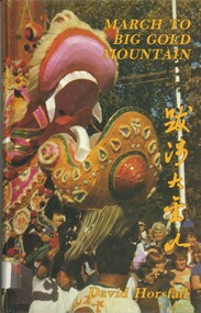
Book - MARCH TO BIG GOLD MOUNTAIN, 1985
March To Big Gold Mountain. Thousands of Chinese landed in South Australia and walked from there to the Central Victorian Goldfields.David Horsfallbendigo, chinese, history, chinese history. -
Moorabbin Air Museum
Book - Modern Civil Aircraft:13, Boeing 727, Peter Gilchrist
The book covers the Boeing 727, designed and built by the Boeing company. It includes the story of its development, design aspects, variants, and who bought it.Purple book with one Picture of the Boeing 727 over mountains on the front and two pictures of the Boeing 727 on the back.non-fictionThe book covers the Boeing 727, designed and built by the Boeing company. It includes the story of its development, design aspects, variants, and who bought it.boeing 727, boeing, airliner -
 National Wool Museum
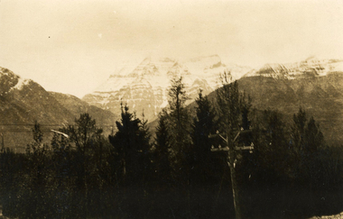
Photograph - Mount Robson, J W Allen, 1928-1929
This photograph was found loose in the second of three albums compiled and owned by J W Allen, Secretary of New South Wales Grazier's, and is associated with the New South Wales Graziers Association world tour of sheep 1928-1929. The album contains photographs of travel, sheep, farms, stations, people and landscapes from around the world. Locations include Kenya, Kinangop, Naivasha, Elementeita, Lake Nakuru, Njoro, Namibia, Otjihavera, Mt Kenya, Isiolo, Yemen, Aden, Suez, River Jordan, Jerusalem, Hebron, Bethlehem, Beersheba, Galilee, Lake Tiberias, Mt Hermon, Canada, Mt Robson, Fraser River Canyon, British Columbia, Merrit, Canford, Alberta, Cardston, Pekisko Creek, Turner Valley, Calgary, Saskatoon, Manitoba, Winnipeg, Portage la Prairie, Niagara Falls, Quebec, Sainte-Anne-de-la-Pocatière and St Lawrence River. Properties depicted include Kenton Estates, Kekopey Ranch, Soysambu Ranch, Larmudiac, SX Ranch, Neilson's Ranch, EP Ranch and CX Ranch. The album was found in a clean out at the Great Southern Agricultural Research Institute and donated to the National Wool Museum, along with other related material such as photographs, glass lantern slides and ephemera.Black and white image showing trees, power pole and power lines in the foreground and snow covered mountains in the background. world tour, sheep, graziers, photograph, canada, agriculture, british columbia, mount robson, mt robson -
 Bendigo Historical Society Inc.
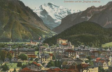
Postcard - ROY AND DORIS KELLY COLLECTION: INTERLAKEN UND DIE JUNGFRAU (4166M), 1900-1920
Postcard, coloured photo of the Swiss city of Interlaken with the snow covered Jungfrau mountain in the distance. Height 4166 metres.postcard, photograph, postcard, interlaken, switzerland, jungfrau -
Lakes Entrance Historical Society
Book, Rogers L C, My Journey from the Snowy River, 1982
Reminiscences of life in remote areas of Victoria at the turn of the Century by a son of a pioneering family of the Black Mountain in East Gippsland.settlers -
 Stawell Historical Society Inc
Postcard, The Balconies Mt Victory in the Grampians -- Postcard
The Balconies Mt Victory The Grampians Valentine Series 1024Black and white photograph of two young people standing between two cliff ledges. Mountain views in the background. Valentine series No. 1024 The Balconies, Mt. Victoria, Grampians Published by the Valentine Publication Co. Pty Ltd. Queens St. Melb.halls gap grampians -
 Kiewa Valley Historical Society
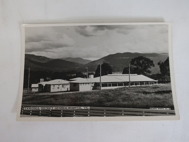
Photo - Tawonga District General Hospital
The hospital was transported from Bonegilla (ex-army hospital ward) and began operations in 1949. It was located at the corner of Ryder's Lane and the Kiewa Valley Highway opposite the Bogong pub. In 1961, the hospital was relocated to the centre of the Mt Beauty town in the former SEC Administration buildingThe Tawonga District General Hospital was created in the late 1940s as the local population grew as a result of the SECV constructing the KHES and the town of Mt Beauty. Prior to this, the nearest hospital was at Yackandandah and medical care was provided by medical practitioners in Mt Beauty.B & W postcard photo showing Tawonga District General Hospital in front of mountains and below a cloudy sky.Printed in white at the bottom left side "Tawonga District General Hospital" and on back "Postcard / A Genuine Photograph"tawonga hospital, medical care, mt beauty hospital., tawonga district general hospital -
 Kiewa Valley Historical Society
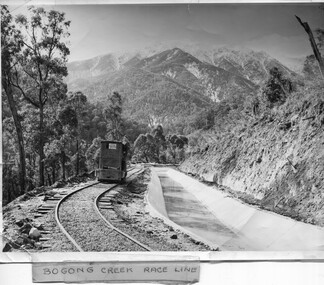
Photo - Bogong Creek Race Line
The SECV constructed the Kiewa Hydro Electric Scheme which included race lines to catch the water and feed it into the dams that they built to create hydro electric power. The rail line was used to construct the race line and enables the race line to be easily checked for maintenance eg. fallen trees The SECV constructed the Kiewa Hydro Electric Scheme from the late 1940s to 1961 being one of the first hydro schemes and hence environmently friendly.Shiny black and white photo showing the railway track, with a locomotive on it, beside the race line. Snow is on the surrounding mountains. ;Bogong Creek Race Line in pen and attafhed to the photo. On the back "Property of / State Electricity Commission of Victoria/ Publicity photo / Permission to Publish must be obtained / and acknowledgement made. / Negative No. 14-138bogong creek race line, kiewa hydro electric scheme -
 Lakes Entrance Historical Society
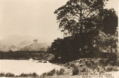
Postcard - Buchan Victoria, H D Bulmer, 1915 c
Sepia toned copy of postcard showing waterway with mountains in distance at Buchan Victoria. Also a second identical photographScene near Buchanagriculture, topography -
Marysville & District Historical Society
Flyer (item) - Brochure, Artworkz Tourism, Marysville-Steavenson Falls, 2018
A brochure including photographs and a tourist map of Marysville and some of the area's attractions focusing on Steavenson Falls. A brochure including photographs and a tourist map of Marysville and some of the area's attractions focusing on Steavenson Falls. The Steavenson Falls is named after the Victorian Assistant Commissioner of Roads and Bridges, John Steavenson who arrived in Victoria in the early 1860s.Shadowed by over 30 Mountains and/ on the banks of the beautiful Goulburn River/ and Lake Eildon. This is our playground.marysville, steavenson falls, victoria, waterfalls, john steavenson -
 Ringwood and District Historical Society
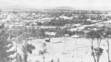
Photograph, A panorama of Ringwood from Mountain View Estate, Loughnan's Hill. (no date)
Typed below photograph, "A Panorama of Ringwood" and written on back of photograph, "Mountain View estate circular". -
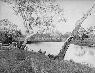 Stawell Historical Society Inc
Photograph, Scene near Lake Lonsdale at Rosehill Station 1872
Scene near Lake Lonsdale 1872 at Rosehill Station (Scoullar and Brinkman) Taken for the Philadelphian Exhibition Similar to Cat No 1309 photo taken by Armstrong 1866Lake Scene with lake and men in punt. Gentleman in top Hat near tree on left.Part of Rosehill Station near Grampians Mountains (Scoullar and Brinkman) Taken for the Philadelphia Exhibition 1872stawell -
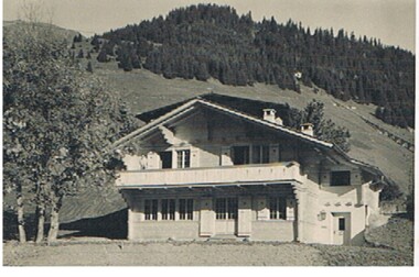 Bendigo Historical Society Inc.
Photograph - HANRO COLLECTION: CHALET
Black and white photograph of a chalet set on the side of a mountain. There is a verandah across the full width of the first floor and one person standing on the left of the verandah. The top third of the mountain is covered in pine trees. There is what appears to be a ski jump running from the edge of the trees to the right of the picture. This is possibly in Switzerlandbuildings, chalet, chalet, hanro -
 Marysville & District Historical Society
Photograph (item) - Colour photograph, Pre 2009
A colour photograph of Steavenson Falls in Marysville in Victoria.A colour photograph of Steavenson Falls in Marysville in Victoria. The Steavenson Falls is named after the Victorian Assistant Commissioner of Roads and Bridges, John Steavenson who arrived in Victoria in the early 1860s.steavenson falls, waterfalls, marysville, victoria, john steavenson -
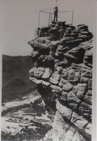 Halls Gap & Grampians Historical Society
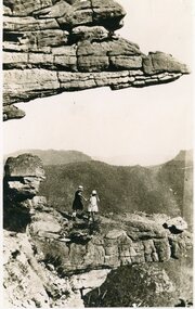
Photograph - B/W
The Pinnacle Lookout with Fyans Valley below. Bellfield Hotel is visible in the lower left of the picture, cleared land is apparent in the middle of the picture.Man standing at a lookout on a rocky outcrop overlooking a valley. Guide rails surround part of the outcop. A mountain range is opposite.scenery, lookouts -
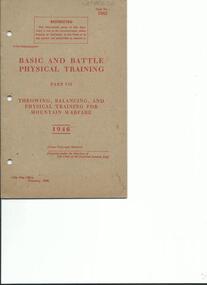 4th/19th Prince of Wales's Light Horse Regiment Unit History Room
Booklet, Basic and Battle Physical Training Part VII 1946, 1946
Soft covered booklet covering throwing, balancing and physical training for mountain warfare, with line drawings of various training skills.WO Code No 7062army physical training, mountain warfare -
 Kiewa Valley Historical Society
Photos - Coloured - Mt Beauty surrounds
5 coloured photos of Mt BEauty surrounds including golf course, lake, mountain with snow and camping -taken recentlymt beauty -
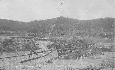 El Dorado Museum Association Inc.
Photograph (item) - Digital Image
Men at Work on the Tail Race, Cocks Pioneer Mine, El Dorado. Cocks Pioneer Electric Gold & Tin Mine Company was formed in 1899. The company's first power station, located at the eastern end of the valley began operating with its 340 Kilowatt steam-powered generator. By 1909, from 2,500,000 cubic yards worked, reported recovery was 17,284 ounces of gold and 224 tons of tin ore. By 1909, Cocks Pioneer’s power plant had become inadequate and uneconomical. The barge was floated downstream about a mile, but lost time caused the operations to cease. Following testing, a new mine was established by diverting Reid's Creek at a cost of £25,000. Settling dams were built, one of which held 1,935,900 cubic feet. Sold earth banks, built against a wall of stringy bark saplings constructed and laced with vertical props, were built. In 1914, the company was reformed as Cock’s Pioneer Gold and Tin Mines NL, another power station was constructed at the western end of the township, near the junction of Clear and Reid's Creeks. From 6,800,000 cubic yards of material processed, the returns were 64,397 ounces of gold and 855 ton of tin. Cocks Pioneer mine then moved the barge downs stream and continued sluicing. In 1929 Cocks Pioneer Electric Gold and Tin Mining Company ceased operations due to a drop in values. Cock’s Pioneer Gold and Tin Mines NL carried on large-scale hydraulic sluicing operations until 1941. Handwritten across the front: 'Cocks Pioneer Mine Eldorado MEN AT WORK ON THE TAIL RACE' / 'THELMA STUDIO / [underlined] WANGARATTA.mining, gold, tin, gold mining, tin mining, cocks pioneer, men, thelma studios, wangaratta, el dorado, eldorado