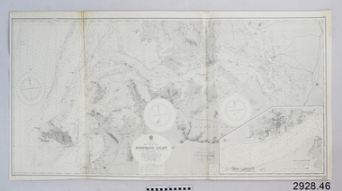
Showing 1087 items matching " navigation"
-
 Vision Australia
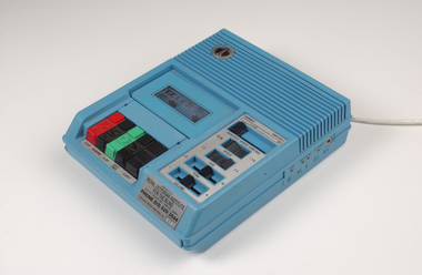
Machine - Object, Telex Corporation, Telex cassette player
A talking book player that allowed the user to change the tone and speed of cassettes played in it. Designed to handle both 4 track and 2 track cassettes, these players were the perfect solution to having both commercial (2 track) and recordings for the blind (4 track) materials without needing separate players. Tonal changes in particular were sometimes required by older listeners, as aging reduces the ability to distinguish high pitch sounds. Speed variability also allowed those who read faster to increase narration, and to slow down reading patterns for listeners with acquired brain injury or other conditions that affected cognitive processing of language.Blue plastic rectangular talking book player with buttons for navigational controls and 5 buttons.Model tbci serial no 8017. Machine number: 8157audio equipment, royal victorian institute for the blind -
 Flagstaff Hill Maritime Museum and Village
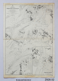
Document - Navigation Chart, Approaches to Chemulpho Anchorage
British Admiralty Navigation Chart - Yellow Sea - Korea East Coast - Approaches to Chemulpho Anchoragewarrnambool, shipwrecked-coast, flagstaff-hill, flagstaff-hill-maritime-museum, maritime-museum, shipwreck-coast, flagstaff-hill-maritime-village, shipwrecked-artefact, navigation chart, british admiralty navigation chart, british admiralty, approaches to chemulpho anchorage, korea -
 Flagstaff Hill Maritime Museum and Village
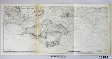
Document - Navigation Chart, Owers to Christchurch with Spithead and the Isle of Wight
British Admiralty Navigation Chart - England - South Coast - Owers to Christchurch with Spithead and the Isle of Wightwarrnambool, shipwrecked-coast, flagstaff-hill, flagstaff-hill-maritime-museum, maritime-museum, shipwreck-coast, flagstaff-hill-maritime-village, shipwrecked-artefact, navigation chart, british admiralty navigation chart, british admiralty, owers to christchurch -
 Flagstaff Hill Maritime Museum and Village
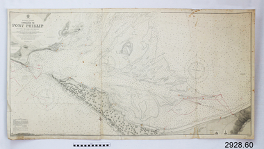
Document - Navigation Chart, Entrance to Port Phillip
British Admiralty Navigation Chart - Australia, Victoria -Entrance to Port Phillip including the Banks and Channels.warrnambool, shipwrecked-coast, flagstaff-hill, flagstaff-hill-maritime-museum, maritime-museum, shipwreck-coast, flagstaff-hill-maritime-village, shipwrecked-artefact, navigation chart, british admiralty navigation chart, british admiralty, entrance to port phillip -
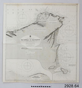 Flagstaff Hill Maritime Museum and Village
Document - Navigation Chart, Africa - North East Coast - Ras Kòrai to Ras Hafun
British Admiralty Navigation Chart - Africa - North East Coast - Ras Kòrai to Ras Hafunwarrnambool, shipwrecked-coast, flagstaff-hill, flagstaff-hill-maritime-museum, maritime-museum, shipwreck-coast, flagstaff-hill-maritime-village, shipwrecked-artefact, navigation chart, british admiralty navigation chart, british admiralty, ras kòrai to ras hafun, gulf of aden, africa : north east coast -
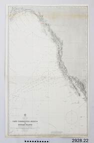 Flagstaff Hill Maritime Museum and Village
Document - Navigation Chart, Cape Cprrientes, Mexico to Kodiak Island
British Admiralty Navigation Chart - North East Pacific - Cape Cprrientes, Mexico to Kodiak Islandwarrnambool, shipwrecked-coast, flagstaff-hill, flagstaff-hill-maritime-museum, maritime-museum, shipwreck-coast, flagstaff-hill-maritime-village, shipwrecked-artefact, british admiralty navigation chart, navigation chart, cape cprrientes,, mexico, kodiak island -
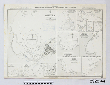 Flagstaff Hill Maritime Museum and Village
Document - Navigation Chart, Plan of Anchorages between Borneo and New Guinea
British Admiralty Navigation Chart - Plan of Anchorages between Borneo and New Guinea with Kayeli Baywarrnambool, shipwrecked-coast, flagstaff-hill, flagstaff-hill-maritime-museum, maritime-museum, shipwreck-coast, flagstaff-hill-maritime-village, shipwrecked-artefact, navigation chart, british admiralty navigation chart, british admiralty -
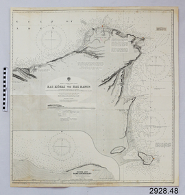 Flagstaff Hill Maritime Museum and Village
Document - Navigation Chart, Africa - North East Coast - Ras Kòrai to Ras Hafun
British Admiralty Navigation Chart - Africa - North East Coast - Ras Kòrai to Ras Hafunwarrnambool, shipwrecked-coast, flagstaff-hill, flagstaff-hill-maritime-museum, maritime-museum, shipwreck-coast, flagstaff-hill-maritime-village, shipwrecked-artefact, navigation chart, british admiralty navigation chart, british admiralty, ras kòrai to ras hafun -
 4th/19th Prince of Wales's Light Horse Regiment Unit History Room
Booklet, Map Reading Aide-Memoire 1973, 1973
Soft covered booklet aimed at assisting with most map reading and navigation problems. 2 copiesDSN 7610-66-058-5570map reading -
Port Melbourne Historical & Preservation Society
Map - Chart, Hobson's Bay, river and navigational aids, 1839 - 1843
On back is handwritten note - Hobson's Bay pp from HMS Beagle 1838-43.Map (Chart) of Hobson's Bay, River and Navigational Aids 1839. (Latrobe Library). in photographic form.melbourne harbor trust - port of melbourne authority, hobson's bay -
 Queenscliffe Maritime Museum
Newspaper - News articles from various newspapers re Queenscliffe, Queenscliff news articles - various from 1981, 3, 6 & 7, c1960 onwards
Port Phillip shipwrecks.Various newspaper articles re Port Phillip navigational, wreckage & ship's draft issues & surveys.Reverse " NIL "port phillip shipping issues. -
Frankston RSL Sub Branch
Calculator, Course & Speed, E.R Watts & Son London Pty Ltd
Course and Speed calculator used as a navigational aid by Air Force pilots to calculate aircraft relative groundspeed whilst allowing for wind speed and direction. A similar example (MKIIA version) can be seen at the following Imperial War Museum web page: Inscribed "COURSE & SPEED CALCULATOR MKII", "E.R.WATTS & Son No 757/35", "A.M. REF No 6B/119".raaf, navigation, calculator, ww2, raf, aircraft, course, speed, wind drift -
 Flagstaff Hill Maritime Museum and Village
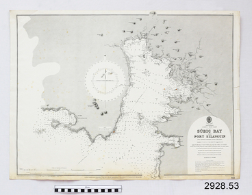
Document - Navigation Chart, Sùbic Bay and Port Silanguin
British Admiralty Navigation Chart - Phillipines - Luzom I. - West Coast - Sùbic Bay and Port Silanguinwarrnambool, shipwrecked-coast, flagstaff-hill, flagstaff-hill-maritime-museum, maritime-museum, shipwreck-coast, flagstaff-hill-maritime-village, shipwrecked-artefact, navigation chart, british admiralty navigation chart, british admiralty, phillipines, sùbic bay and port silanguin -
 Flagstaff Hill Maritime Museum and Village
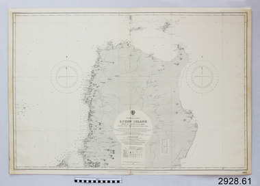
Document - Navigation Chart, Luzon Island, North of Latitude 16° 20' north
British Admiralty Navigation Chart - Phillippine Islands - Luzon Island, North of Latitude 16° 20' northwarrnambool, shipwrecked-coast, flagstaff-hill, flagstaff-hill-maritime-museum, maritime-museum, shipwreck-coast, flagstaff-hill-maritime-village, shipwrecked-artefact, navigation chart, british admiralty navigation chart, british admiralty, luzon island -
 Flagstaff Hill Maritime Museum and Village
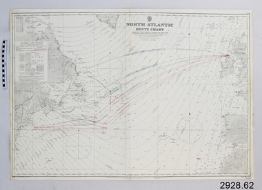
Document - Navigation Chart, North Atlantic : Route Chart showing Lane Routes North of Ireland
British Admiralty Navigation Chart - North Atlantic : Route Chart showing Lane Routes North of Irelandwarrnambool, shipwrecked-coast, flagstaff-hill, flagstaff-hill-maritime-museum, maritime-museum, shipwreck-coast, flagstaff-hill-maritime-village, shipwrecked-artefact, navigation chart, british admiralty navigation chart, british admiralty, north atlantic, route chart -
 Flagstaff Hill Maritime Museum and Village
Document - Navigation Chart, Chinnampo Ko, Pingyang Inlet : Yellow Sea, West Coast of Korea
British Admiralty Navigation Chart, Chinnampo Ko, Pingyang Inlet : Yellow Sea, West Coast of Koreawarrnambool, shipwrecked-coast, flagstaff-hill, flagstaff-hill-maritime-museum, maritime-museum, shipwreck-coast, flagstaff-hill-maritime-village, shipwrecked-artefact, navigation chart, british admiralty navigation chart, british admiralty, pingyang inlet, chinnampo ko -
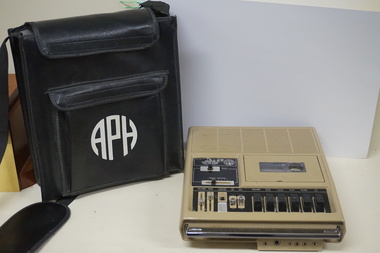 Vision Australia
Equipment - Object, General Electric, APH Table top cassette player, 1978-1981
Produced by General Electric (GE) for American Printing House for the Blind in Kentucky, this player has dials to control tone, volume, speed, side and buttons to record, rewind, forward, play, pause and stop tape. Handling both 2 and 4 track tapes, these players were targeted towards the vision impaired, as it allowed greater freedom to adjust recording styles to suit individual listeners. Plastic rectangular brown audio player with buttons for navigational controls, a handle and black vinyl carry pouch.audio equipment, assistive devices -
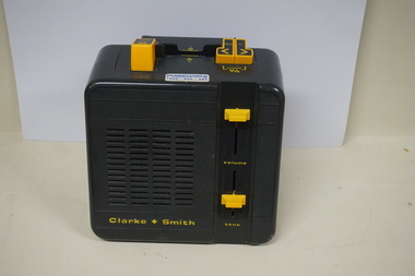 Vision Australia
Equipment - Object, Clarke & Smith, Easiplay 2, 1990's
This Easiplay 2 model was produced by CSI (Clarke & Smith Industries) using a combination of overseas and locally made parts; however demand for compact discs was increasing by this time and the players were not financially viable. After the death of John Clarke in 1997 and the subsequent loss of it's major contract with RNIB, the company was wound up in 2004.Plastic rectangular grey coloured audio player with buttons for navigational controls, power cord and 3 buttons Clarke + Smith Model 1322 Serial number 9701-0011audio equipment, clarke and smith -
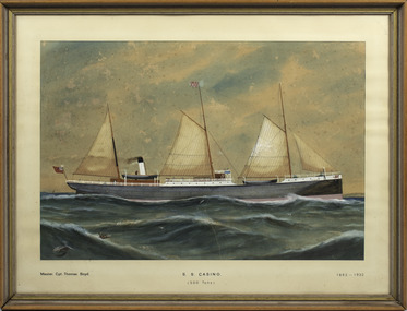 Port Fairy Historical Society Museum and Archives
Painting - Watercolour, s.s. Casino, 1882
Decoration in the home of Mr W. HarrisA beautiful illustration of the s.s.Casino an iconic ship on the Western Seaboard for almost 50 years.Watercolour painting of "S.S.Casino" with inscription underneathG.F.G.?82 "The Belfast and Koroit Steam Navigation Co's S.S."Casino" 425 tonslocal history, illustrations, watercolours, belfast and koroit steam navigation company -
 Nhill Aviation Heritage Centre
Black and white photograph, Local photograph. Original of this scan held by Nhill Historical Society, Aeradio Building c1937
This building is still intact at the Nhill Aerodrome. Some of the infrastructure is also in place or can be evidenced by its foundations.The Aeradio building was built on the present aerodrome in 1937. This was one of only sixteen buildings of this type built across Australia and it housed radio communications and guidance equipment. The building and its equipment were part of a comprehensive system of radio towers, signalling and meteorology equipment aimed at providing safer navigation for aircraft travelling throughout Australia. The facility closed in the 1960sThis photo is significant due to it having been taken soon after the building was constructed. It is the earliest known photograph taken on an open to the public day before the receiver aerials were erected.The Aeradio building was built on the present (2012) aerodrome in 1937 or 1938. This was one of only fifteen buildings of this type built across Australia and it housed radio communications and guidance equipment. The building and its equipment were part of a comprehensive system of radio towers lights and signalling equipment aimed at providing safer navigation for aircraft travelling throughout Australia. The facility closed in the 1960sphoto, aeradio, early, civil aviation, dca, dept of civil aviation -
 Flagstaff Hill Maritime Museum and Village
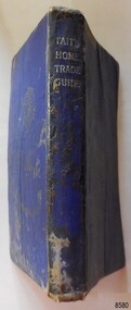
Book - Technical Reference, James Tait, Extra Master and Author et al, Tait's Home Trade Guide to the Board of Trade Examinations for Mates and Masters, 1943
The book includes navigational information, tables and maps, diagrams and formulas. It was written for Examiners and Students studying for their nautical Mates and Masters marine qualifications— notes have been handwritten inside the front and back covers. Notes in point form: 1. I have seen the back of a torpedo EBoat or UBoat in my starboard side 2. I _ _ _ to - - - - - - - - - Port side 3. at a distance ----------- 4. Enemy surface vessel in sight __________ 5. suspicious vessel in sight 6. enemy (undecipherable) 7. I have cut a _ _ _ adrift with my _ _ 8. FI_ _ WISE _ _ _ 9. STARWISE 0. OPEN FIREThis relatively rare book provided up-to-date navigational information during World War II. It was to be used by Examiners to assess whether students qualified to be a Ship's Mate or Ship's Master. The contents of the book were based on maritime knowledge gained over centuries. It is an aid to understanding the navigational methods of the time and the changes and improvements in more recent history.Title: Tait's Home Trade Guide: to the Board of Trade Examinations for Mates and Masters Author: James Tait, Extra Master Publisher: Brown, Son and Ferguson, Ltd. Glasgow, Great Britain Date: Revised Edition 1943 Further Information: Fourteenth Edition 1941, Reprinted Edition 1943. Revised and brought up to date by Captain H. T. Jefferys, Extra Master Printed by Nautical Press, Brown, Son & Ferguson, Limited, 52-58 Darnley Street, Glasgow Hardcover, small book, royal blue cover, silver embossed text on spine. Textbook for Mariners. Includes tables and maps, diagrams and formulas, and navigational information. The inside covers of this book contain handwritten calculations, diagrams and notes that refer to navigation. Notes inside the back cover refer to an enemy vessel and OPEN FIRE.Spint, in silver embossing "TAIT'S HOME TRADE GUIDE" Handwritten inside the back cover "R.A.D. / MOORE / PT. WELCH" Included with the text inside the back cover "Gascoyne" "506" and "RCM"flagstaff hill, warrnambool, shipwrecked coast, flagstaff hill maritime museum, maritime museum, shipwreck coast, flagstaff hill maritime village, great ocean road, james tait, brown, son and ferguson limited, torpedo, open fire, pt welch, vessel gascoyne, e-boat, u-boat, marine technology, world war ii, wwii, ww2, navigation exams, ship's mate, ship's master, wwii textbook, nautical textbook, navigational textbook, examination textbook, world war ii textbook, 1943 nautical textbook -
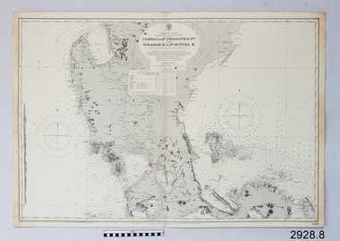 Flagstaff Hill Maritime Museum and Village
Document - Navigation Chart, Cabra I. to San Fernando Pt and Dilasak B to St. Miguel B
British Admiralty Navigation Chart. Cabra I. to San Fernando Pt and Dilasak B to St. Miguel Bwarrnambool, shipwrecked-coast, flagstaff-hill, flagstaff-hill-maritime-museum, maritime-museum, shipwreck-coast, flagstaff-hill-maritime-village, shipwrecked-artefact, british admiralty navigation chart, navigation chart, cabra i. to san fernando pt and dilasak b to st. miguel b -
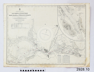 Flagstaff Hill Maritime Museum and Village
Document - Navigation Chart, California - San Pablo and Suisun Bays including Mare Island and Carquinez straits
British Admiralty Navigation Chart - California - San Pablo and Suisun Bays including Mare Island and Carquinez Straitswarrnambool, shipwrecked-coast, flagstaff-hill, flagstaff-hill-maritime-museum, maritime-museum, shipwreck-coast, flagstaff-hill-maritime-village, shipwrecked-artefact, british admiralty navigation chart, navigation chart, california, suisun bay, san pablo bay, mare island strait, carquinez straitt -
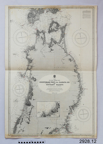 Flagstaff Hill Maritime Museum and Village
Document - Navigation Chart, Japan, Ishinomaki Wan ( Sensai Bay) and Sakata Ko to Tsugaru Kaikyo (Strait)
British Admiralty Navigation Chart -- Japan, Ishinomaki Wan ( Sensai Bay) and Sakata Ko to Tsugaru Kaikyo (Strait)warrnambool, shipwrecked-coast, flagstaff-hill, flagstaff-hill-maritime-museum, maritime-museum, shipwreck-coast, flagstaff-hill-maritime-village, shipwrecked-artefact, british admiralty navigation chart, navigation chart, ishinomaki wan ( sensai bay), sakata ko to tsugaru kaikyo (strait) -
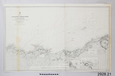 Flagstaff Hill Maritime Museum and Village
Document - Navigation Chart, C. Bougaroni to Fratelli Rocks including the Galita Channel
British Admiralty Navigation Chart - Africa, North Coast - C. Bougaroni to Fratelli Rocks and including The Galita Channelwarrnambool, shipwrecked-coast, flagstaff-hill, flagstaff-hill-maritime-museum, maritime-museum, shipwreck-coast, flagstaff-hill-maritime-village, shipwrecked-artefact, british admiralty navigation chart, navigation chart, c. bougaroni to fratelli rocks including the galita channel -
 Queenscliffe Maritime Museum
Tool - Light, anchor, 20 March 2018
An anchor light is a white light visible from all around the vessel and is required when anchored or moored between sunset and sunrise. The best place for this light is usually at the top of the highest mast.Example of a kerosene lamp used as an at anchor light.Navigational Light or Riding Light run on oil or kerosene which is displayed by a ship at night when lying at anchor.night light, navigational lighting, kerosene lamp, sailing ships -
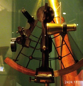 Flagstaff Hill Maritime Museum and Village
Instrument - Sextant, Late 20th Century
In 1941, the scientific instrument manufacturing firms of Henry Hughes & Son Ltd, London, England, and Kelvin Bottomley & Baird Ltd, Glasgow, Scotland, came together to form Kelvin & Hughes Ltd. Kelvin Company History: The origins of the company lie in the highly successful and strictly informal relationship between William Thomson (1824-1907), Professor of Natural Philosophy at Glasgow University from 1846-1899 and James White, a Glasgow optical maker. James White (1824-1884) founded the firm of James White, an optical instrument maker in Glasgow in 1850 and was involved in supplying and mending apparatus for Thomson university laboratory and working with him on experimental constructions. White was declared bankrupt in August 1861 and released several months later. In 1870, White was largely responsible for equipping William Thomson laboratory in the new University premises at Gilmore hill. From 1876, he was producing accurate compasses for metal ships to Thomson design during this period and this became an important part of his business in the last years of his life. He was also involved in the production of sophisticated-sounding machinery that Thomson had designed to address problems encountered laying cables at sea, helping to make possible the first transatlantic cable connection. At the same time, he continued to make a whole range of more conventional instruments such as telescopes, microscopes and surveying equipment. White's association with Thomson continued until he died. After his death, his business continued under the same name, being administered by Matthew Edwards (until 1891 when he left to set up his own company. Thomson who became Sir William Thomson and then Baron Kelvin of Largs in 1892, continued to maintain his interest in the business after James White's death. In 1884 raising most of the capital needed to construct and equip new workshops in Cambridge Street, Glasgow. At these premises, the company continued to make the compass Thomson had designed during the 1870s and to supply it in some quantity, especially to the Admiralty. At the same time, the firm became increasingly involved in the design, production and sale of electrical apparatus. In 1899, Lord Kelvin resigned from his University chair and became, in 1900, a director in the newly formed limited liability company Kelvin & James White Ltd which had acquired the business of James White. At the same time Kelvin's nephew, James Thomson Bottomley (1845-1926), joined the firm. In 1904, a London branch office was opened which by 1915 had become known as Kelvin, White & Hutton Ltd. Kelvin & James White Ltd underwent a further change of name in 1913, becoming Kelvin Bottomley & Baird Ltd. Hughes Company History: Henry Hughes & Sons were founded in 1838 in London as a maker of chronographic and scientific instruments. The firm was incorporated as “Henry Hughes & Sons Ltd” in 1903. In 1923, the company produced its first recording echo sounder and in 1935 a controlling interest in the company was acquired by S Smith & Son Ltd resulting in the development and production of marine and aircraft instruments. Following the London office's destruction in the Blitz of 1941, a collaboration was entered into with Kelvin, Bottomley & Baird Ltd resulting in the establishing “Marine Instruments Ltd”. Following the formal amalgamation of Kelvin, Bottomley & Baird Ltd and Henry Hughes & Sons Ltd in 1947 to form Kelvin & Hughes Ltd. Marine Instruments Ltd then acted as regional agents in the UK for Kelvin & Hughes Ltd who were essentially now a part of Smith's Industries Ltd founded in 1944 and the successors of S. Smith & Son Ltd. Kelvin & Hughes Ltd went on to develop various marine radar and echo sounders supplying the Ministry of Transport, and later the Ministry of Defence. The firm was liquidated in 1966 but the name was continued as Kelvin Hughes, a division of the Smiths Group. In 2002, Kelvin Hughes continues to produce and develop marine instruments for commercial and military. G. Falconer Company History: G Falconer (Hong Kong Ltd) appear to have had a retail presence in Hong Kong since 1885, according to the company website, and currently have a shop in the Peninsula Hotel. G Falconer was the Hong Kong selling agent for several British companies. Ross Ltd of 111 New Bond St London was one and the other was Kelvins Nautical Instruments. Falconers were primarily watchmakers, jewellers and diamond merchants.They were also agents for Admiralty Charts, Ross binoculars and telescopes, and sold English Silverware and High Class English Jewellery. In 1928 the company was operating from the Union Building opposite the Hong Kong general post office. It is unclear if the item is an original Sextant made by Kelvin prior to his amalgamation with Henry Hughes & Sons in 1941 as Kelvin appears to have only made compasses up to this date. If the Sextant can be established that it was made by Kelvin then it is very significant and a rare item made for and distributed through their Hong Kong selling agents G Falconer Ltd. There are many Sextants advertised for sale stating "Kelvin & Hughes 1917 model sextant". These can be regarded as replicas as the company was not formed until 1941 and production of marine instruments was not fully under way until after the war in 1947. Further investigation needs to be undertaken to accurately determine the provenance of this item. As the writer currently has the impression that the subject object was possibly made by Kelvin and Hughes in the mid to late 20th century or is a replica made by an unknown maker in the late 1970s. Purchased as an exhibition of marine navigational instruments for the Flagstaff Hill museum. The Sextant is a brass apparatus with filters and telescope lens, and comes with a wooden felt lined storage box. It is a doubly reflecting navigation instrument that measures the angular distance between two visible objects. The primary use of a sextant is to measure the angle between an astronomical object and the horizon for the purposes of celestial navigation.G Falconer and Co. Hong Kong (retailers of nautical equipmentflagstaff hill, warrnambool, shipwrecked-coast, flagstaff-hill, flagstaff-hill-maritime-museum, maritime-museum, shipwreck-coast, flagstaff-hill-maritime-village, sextant, kelvin & hughes ltd, hong kong, navigational instrument, g falconer, mariner's quadrants -
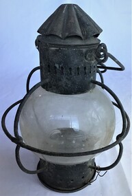
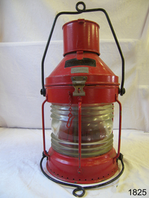 Flagstaff Hill Maritime Museum and Village
Functional object - Ships Navigation Lamp, William Harvie & Co, First half of the 20th century
William Harvie was granted a patent in 1868 for improvements in the manufacture of lamps, lanterns and lenses for ships navigation and signal lamps 1868. Production began at 222 Broomielaw street Glasgow Scotland. Another patent was issued in 1873 for additional improvements to the companies lamps. Records show that in1873 William Harvie was in partnership with Malcolm Graham & Co, grease manufacturers and rosin distillers at 50 Anderson Street Gallowgate Glasgow. It appears around this time the business was transferred to George Moffat of 128 Garthland Drive Dennistoun Glasgow to continue under the same name (William Harvie & Co at premises situated at 100 East John St Gallowgate Glasgow. It is unclear but at some point W T George & Co were one in the same with William Harvie & Co. W T George made lamps with the trade name “Meteorite” and after gaining a patent for improvements to his lamps in 1941 the patent numbers were affixed to his lamps. In the Scottish Post Office annual Glasgow Directory 1900-1902 William Haveie & Co. Ltd is listed with two addresses; 222 Broomielaw and 24 McAlpine Streets, Glasgow. In the early 20th century the business moved to Birmingham until 1983 when the company went into voluntary liquidation after a meeting was held at Newhall Street Birmingham on the 10th January 1983 for WT George and William Harvie. This meeting was for the purposes regarding the insolvency of a company as set out in Sec 294 & 295 of the companies Act 1948 as a result Harvie & Co cease production of their products.An item made by a company that was an innovator of significant improvements in the manufacture of marine signal and navigation lamps during the late 19th and 20th centuries. Lamps made by this manufacturer are now sought after collector's items that are of significant value. Navigation lamp, round ship's lamp with clear glass and a red filter, handle at top, fitted with hinged and catch section at top to service lamp. Bracket at back for hanging lamp item painted red with black handles.Black nameplate is unreadable. Front reference plate reads " Meteorite" then "Meteorite No. 92276" warrnambool, flagstaff-hill, flagstaff-hill-maritime-museum, maritime-museum, shipwreck-coast, flagstaff-hill-maritime-village, lamp, meteorite, william harvie, navigation lamp, kerosene lamp, signal lamp, marine equipment, marine navigation, w t george & co, george bocock & co, william harvie & co. ltd. -
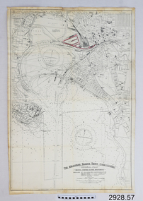 Flagstaff Hill Maritime Museum and Village
Document - Navigation Chart, The Melbourne Harbor Trust Commissioners
Navigation Chart - The Melbourne Harbor Trust Commissioners - General Plan - Shewing proposed Harbor Improvements. Hobson's Bay and Citywarrnambool, shipwrecked-coast, flagstaff-hill, flagstaff-hill-maritime-museum, maritime-museum, shipwreck-coast, flagstaff-hill-maritime-village, shipwrecked-artefact, navigation chart, hobson's bay, the melbourne harbor trust -
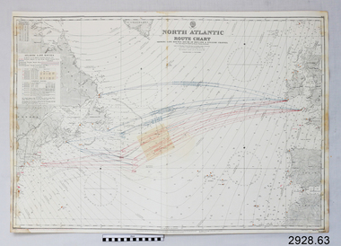 Flagstaff Hill Maritime Museum and Village
Document - Navigation Chart, North Atlantic : Route Chart showing Lane Routes South of Ireland & English Channel
British Admiralty Navigation Chart - North Atlantic : Route Chart showing Lane Routes South of Ireland & English Channelwarrnambool, shipwrecked-coast, flagstaff-hill, flagstaff-hill-maritime-museum, maritime-museum, shipwreck-coast, flagstaff-hill-maritime-village, shipwrecked-artefact, navigation chart, british admiralty navigation chart, british admiralty, north atlantic route chart, north atlantic