Showing 1007 items
matching paddocks
-
 Sunbury Family History and Heritage Society Inc.
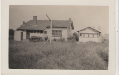
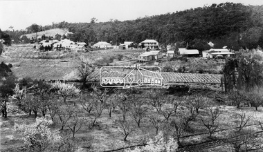
Photograph, c1920s - 1930s
In the 1920s a few Californian style homes were built in the township of Sunbury and some of them can still be seen in the town.A black and white photograph of the rear view of a weatherboard Californian style bungalow built in an open paddock. The house also has a smaller building on the RHS and an outdoor toilet as well as a double clothes line are in the yard. sunbury township. -
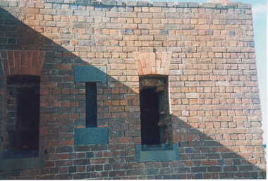 Clunes Museum
Photograph, KODAK, 1999
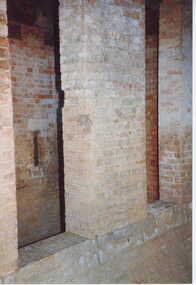
VIEW OF POWDER MAGAZINE USED IN MINING DAYS TO STORE EXPLOSIVES. BUILDING MATERIALS SOLID BRICKCOLOURED REPRINT PHOTOGRAPH OF POWDER MAGAZINE EXTERIOR. SITUATED IN A PADDOCK ON SMEATON ROAD APPROX. 2 KM. FROM TOWNSHIP ON LEFT HAND SIDE. A SOLID BUILDING WITH TWO OPENINGS AND ONE SMALL WINDOWlocal history, photography, photographs, mining -
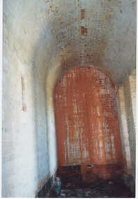 Clunes Museum
Photograph, KODAK, 1999
VIEW OF POWDER MAGAZINE USED IN MINING DAYS TO STORE EXPLOSIVES. BUILDING MATERIALS SOLID BRICKCOLOURED PRINT PHOTOGRAPH OF POWDER MAGAZINE INTERIOR. SITUATED IN A PADDOCK ON SMEATON ROAD APPROX. 2 KM. FROM TOWNSHIP ON LEFT HAND SIDE. SHOWING ARCHED ROOF SMALL WINDOW IN LEFT WALL.local history, photography, photographs, mining -
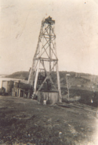 Lakes Entrance Historical Society
Photograph, Oil bore off Myers Street Lakes Entrance Victoria, 1930 c
Sepia toned photograph of oil bore off Myers Street looking towards Jemmy's Point. Derrick is constructed of timber, located in what was known as Butcher's Paddock O'Neills Road Lakes Entrance Victoriaoil and gas industry, engineering, social history -
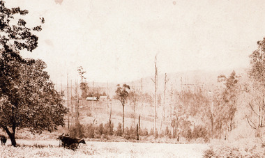 Mt Dandenong & District Historical Society Inc.
Photograph, Across the Creek to Falls Road c1920, c1920
Mt Dandenong. Cow in paddock, looking to two houses in Falls Road. One probably belonging to a Mr. Mason.Sepia photograph of rural scene. Two cows and calf in foreground with houses, crops and trees in background.mount dandenong, falls road, cow, mason -
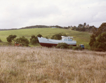 Lakes Entrance Historical Society
Photograph - Erin, 1990c
Another copy shows it being transported across paddocks from Campbells Airfield, where it was built, built by Haslam.Colour photograph of fishing boat Erin J taken adjacent to the slipway before launching. Lakes Entrance Victoriafishing industry, ships and shipping, transport -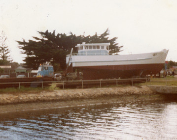
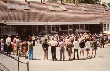 Ringwood and District Historical Society
Photograph, Ringwood State School -Opening of Daisy Paddock Library,1974
Coloured photographs."Comments with photographs" Opening of Daisy Paddock Library, 23rd November, 1974. Photograph (a): Speaker, Mr.Noel James. Photograph (c): Speaker, Sir Ronald East. Photograph (d): Unveiling of Library Plaque. -
 Eltham District Historical Society Inc
Photograph, View at Hurstbridge, 1924
View of Hurstbridge township overlooking fruit trees in flower in the foregaround and ploughed paddocks ready for crop planting in the middle of the photo.This photo forms part of a collection of photographs gathered by the Shire of Eltham for their centenary project book, "Pioneers and Painters: 100 years of the Shire of Eltham" by Alan Marshall (1971). The collection of over 500 images is held in partnership between Eltham District Historical Society and Yarra Plenty Regional Library (Eltham Library) and is now formally known as The Shire of Eltham Pioneers Photograph Collection.' It is significant in being the first community sourced collection representing the places and people of the Shire's first one hundred years.Digital imagesepp, shire of eltham pioneers photograph collection, hurstbridge, orchard, fruit trees -
 Federation University Historical Collection
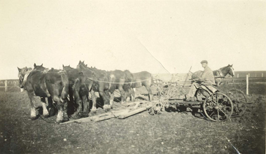
Photograph, Farming scene in the Wimmera, c1915, c1915
A team of eight horses being driven by a man to prepare a paddock. In the background another horse is also yoked up to a machine.Black and white photograph of a farming scene in the Wimmera, VictoriiaVerso: Scene in the Wimmera about 1915farm, horse team, agriculture, wimmera c1915, ploughing, farming c1915 -
 Halls Gap & Grampians Historical Society
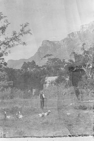
Photograph - B/W
This is a pastoral scene in halls Gap. The building is the Halls Gap Public Hall.The photo shows a man with a hat and long walking stick standing in a paddock with a number of geese. In the middle distance is a building surrounded by fruit trees. Behind this tall eucalyptus trees can be seen and in the background is a rocky range.mining, equipmment -
 Whitehorse Historical Society Inc.
Document, Aspinall's Estate, Box Hill, 1937
List of allotments to be sold by the City of Box Hill for municipal charges in Mont Albert, Box Hill, Surrey Hills and Burwood in 1937. Also 8 small farm blocks in Aspinall's Estate (Old Abattoirs Paddock).land sales, mont albert, box hill, surrey hills, burwood, aspinalls estate, aspinall road, box hill north, woodhouse grove, abattoirs paddock, edward haughton pty ltd -
 Southern Sherbrooke Historical Society Inc.
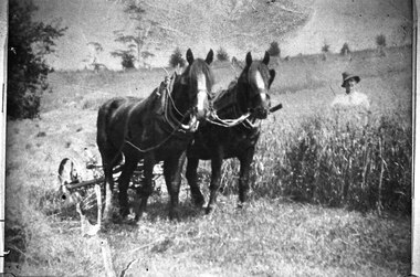
Photograph - Glen Park Farm, Selby
B&W photo shows two horses harnessed to a harvester or grass cutter. A worker dressed in pale shirt and hat stands to their left, behind chest-high grass. They are in a large paddock with trees dotted around. -
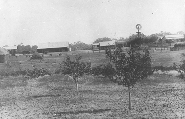 Tarnagulla History Archive
Photographs: Rosemont Homestead, Laanecoorie, Rosemont Homestead, Laanecoorie, 1896
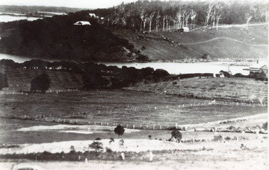
Murray Comrie Collection. Rosemont was the residence of John E. Douglas and Maryan Douglas Two copies of a monochrome photograph, image depicting open paddocks with small fruit trees, several buildings and a windmill in background. This is a slightly dark copy of an older original. Copy probably made by Murray Comrie in the 1960s.laanecoorie, rosemont, douglas, farms -
 Clunes Museum
Photograph, KODAK, 1999
VIEW OF POWDER MAGAZINE USED IN MINING DAYS TO STORE EXPLOSIVES. BUILDING MATERIALS SOLID BRICKCOLOURED PRINT PHOTOGRAPH OF POWDER MAGAZINE EXTERIOR. SITUATED IN A PADDOCK ON SMEATON ROAD APPROX. 2 KM. FROM TOWNSHIP ON LEFT HAND SIDE. LEAFLESS TREE IN FOREGROUND - FALLEN TREE BESIDE IT EASTERN ASPECT.local history, photography, photographs, mining -
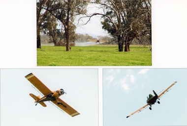 Stawell Historical Society Inc
Photograph, Crop Dusting at Campbell's Bridge
Crop Dusting Ken Hyslop Campbells Bridge. Three colour photographs. Paddock scene with crop dusting airplane. Two of Airplane. -
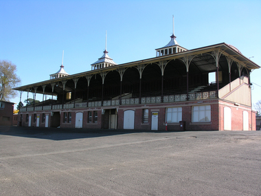 Ballarat Heritage Services
Photograph - Grandstand, Grandstand, City Oval, Ballarat
Originally known as Yuille's paddock, this oval is now called the City Oval. It is near Lake Wendouree previously known as Yuille's Swamp.Colour photograph of the City Oval grandstand, Ballaratcity oval grandstand, grandstand, ballarat -
 Bendigo Historical Society Inc.
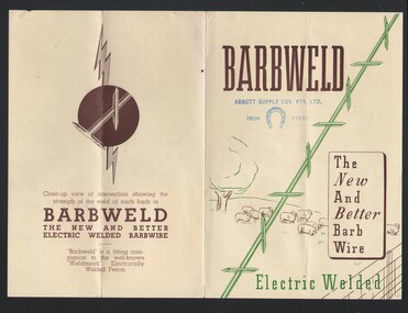
Book - ABBOTT COLLECTION: BARBWELD BOOKLET
Booklet; buff coloured cover, printed with Barbweld, the new and better barb wire, electric welded. Image on front of sheep in paddock and barb wire. Barbweld was a later improved design of barbed wire from the makers of Barblok.bendigo, industry, abbott supply, abbott supply, barbweld, barbwire, advertising -
 Bendigo Historical Society Inc.
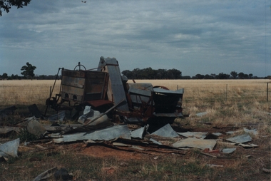
Photograph - ROY J MITCHELL COLLECTION: SEED DRILL GOORNONG
Colour photograph of farm machinery in paddock near Goornong. Machinery is in a dilapidated condition. Written on back : '29.3.96' farm machinery (seed drill) near Goornong Victoria 14.30 hrs, 29.3.1996 by Roy J Mitchell, Bendigo'Roy J Mitchellagriculture, machinery, seed drill -
 Bendigo Historical Society Inc.
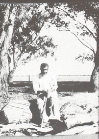
Photograph - HARRY BIGGS COLLECTION: UNKNOWN MALE
Photograph ( proof 42) of an unknown man in casual clothes. He is seated on a log and is holding what appears to be a walking stick He is of Aboriginal descent. Two trees and a fence line and cleared paddock can be seen in the backgroundperson, individual, aboriginal, koori, log, individual -
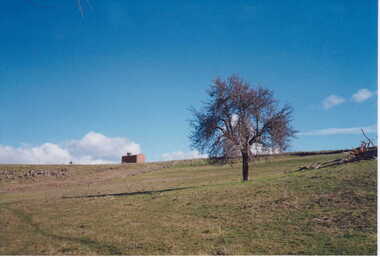
 Hume City Civic Collection
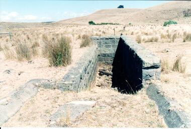
Photograph, Early 1990's
This is a photograph of one of the many stone ruins which can be seen in the Sunbury area and surrounding districts. These ruins are found in varying degrees of structural damage caused by erosion, vegetation growth and vandalism. The bluestone structure was a sheep dip on the 'Karoora Park' property near Jacksons Creek.A coloured photograph of the stone remains of a sheep dip constructed from basalt rock. The ground at the entrance slopes down into a narrow walled channel. The surrounding paddocks are covered with tussocks of grass and there are bare hills in the background. The grass is brown.stone structures, sheep dips, basalt rock, 'karoora park', george evans collection -
Whitehorse Historical Society Inc.
Article, Volunteers set to work on heritage grounds, 2006
Volunteers to be enlisted to restore historic Crown Land abutting Schwerkolt Cottage, known as 'The Horse Paddock' (photo)Volunteers to be enlisted to restore historic Crown Land abutting Schwerkolt Cottage, known as 'The Horse Paddock' (photo) Judith Fry, Barbara Gardiner, Rob Hulls (Vic Planning & environment Minister), Sharon Ellis (Whitehorse Mayor)Volunteers to be enlisted to restore historic Crown Land abutting Schwerkolt Cottage, known as 'The Horse Paddock' (photo)voluntary workers, schwerkolt cottage, hull, rob, ellis, sharon, fry, judith, gardiner, barbara -
 Kew Historical Society Inc
Photograph - Flooding of the Yarra Valley at Kew East, 1974
Flooding of the Yarra Valley, including that section of the Yarra bordering Kew and Kew East in the north and west of the municipality, was a regular occurrence. Extreme flood events of the Yarra River are recorded to have occurred in 1891, 1901, 1916, 1923 and 1934. The Municipality of Kew's response to these floods was to enact planning decisions restricting residential development in flood prone areas following the floods of 1916, 1921 and 1934. While floods continued after the development of the Upper Yarra Reservoir (construction 1948-57), the regularity and extent of these inundations diminished. During the nineteenth century, the land abutting the south side of the Yarra in Kew was devoted to dairy farming. In the twentieth century, before and after the construction of the Eastern Freeway, much of this low-lying area was used as golf courses and public parks.Late example of the capacity of the Yarra Valley at Kew to flood, even though drainage works and the Upper Yarra Reservoir had reduced their regularity.Original black and white print photograph of Hay's Paddock under floodwater on 16 May 1974. The vantage point of the photographer is Keystone Crescent looking east. Flooding was caused by overflowing water in Glass' Creek and the River Yarra. Annotation verso: "Keystone Cr looking east / 16 May 1974 11.50am"hays paddock, floods, yarra river, glass' creek -
 Lakes Entrance Historical Society
Photograph - Butcher's Paddock, 1935c
Copied from postcard in possession of Mrs Vera BennettBlack and white photograph of cleared land on each side of the North Arm, showing white ring barked trees in front of dense bush on western side, cleared and fenced paddocks on eastern side. Lakes Entrance VictoriaPanorama scene at Seaview Tearooms - Lakes Entrancetownship, waterways -
 University of Melbourne, Burnley Campus Archives
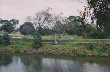
Photograph - Colour print, Konica, Lagoon or Boulevard Paddock, Unknown
2 colour photographs. 1. Lagoon or Boulevard Paddock and Quad Classrooms from the other side of the Yarra River. 2.View towards the rock bank behind Swan Street from the other side of the Yarra River.lagoon paddock, boulevard paddock, quad classrooms, yarra river -
 Linton and District Historical Society Inc
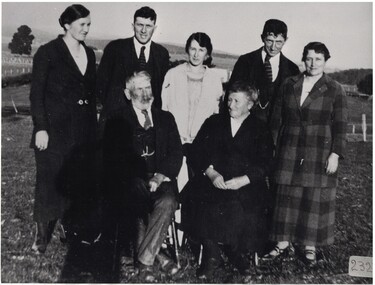
Photograph, Mr and Mrs John Reid and family
Black and white copy of original photo showing a group of five people standing, two men and three women behind two older people sitting, one male with a beard and one female. Taken outside in a paddock. "Mr and Mrs John Reid and family. Standing L-R: Sarah (Mrs V.M. Gray); Norman; Violet (Mrs Carl Hoffman); Thomas; Mary (Mrs Rowe); Mr John Reid & Mrs Reid (nee Anne Easterbrook).john reid, anne reid nee easterbrook, sarah gray nee reid, norman reid, violet hoffman nee reid, thomas reid, mary rowe nee reid -
 Sunbury Family History and Heritage Society Inc.
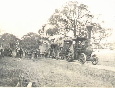
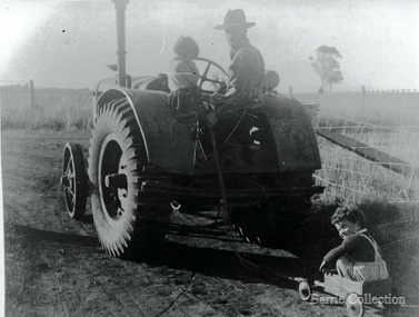
Photograph, Traction engine
Steam-driven traction engines had a variety of uses on farms before petrol and diesel power motors were developed. The one in the photograph is hauling a farm shed to a specific location.A non-digital black and white photograph of a steam-driven traction engine pulling hauling equipment and a small wooden building along an unmade track. A group of men are standing at the rear by the track supervising the shift. There are trees in the paddock.steam-driven traction engines, farms -
 Clunes Museum
Photograph, KODAK, 1999
VIEW OF POWDER MAGAZINE USED IN MINING DAYS TO STORE EXPLOSIVES. BUILDING MATERIALS SOLID BRICKCOLOURED PRINT PHOTOGRAPH OF POWDER MAGAZINE INTERIOR. SITUATED IN A PADDOCK ON SMEATON ROAD APPROX. 2 KM. FROM TOWNSHIP ON LEFT HAND SIDE. SMALL WINDOW IN LEFT HAND WALL SOLID STEP LEADING TO RECESS.local history, photography, mining, powder magazine -
 Greensborough Historical Society
Photograph - Digital Image, Across Greensborough Station, 1973c, 1973c
Looking across Greensborough Station. Taken from Varalla's corner Para Road and Flintoff Street. Turning Pope's Paddock into the Poulter Reserve.Digital copy of black and white photograph. trains, greensborough station, popes paddock, poulter reserve greensborough -
 Melton City Libraries
Photograph, Wendy, Bon and Peter Barrie, c.1948
Sections of the property from the Ferris Rd to the Toolern Creek were compulsorily acquired for the construction of the Melton By Pass road to become the Western Freeway. The freeway plan divided the original 1911“Darlingsford” farm. The section of the Ferris Rd 70-acre paddock belonging to Bon became the Freeway and roundabout. The construction to the west passed over the paddocks and the internal track along the fences connecting the Barrie brothers to the original Homestead at the Toolern Creek. Wendy, Bon and Peter Barrie entering Ferris Road from houselocal identities