Showing 27531 items
matching rd ?
-
 City of Moorabbin Historical Society (Operating the Box Cottage Museum)
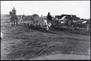
Photograph, Black & White Oakleigh Hunt Club in Jasper Rd c 1920, c1920
The Melbourne Hunt Club was founded by Mr George Watson in 1852 with hounds brought to Australia from Ireland and moved its headquarters a number of times as the city grew between 1897 and 1929, The kennels were originally at Kirk's Bazaar, in Bourke Street, Melbourne, subsequently they moved to St Kilda, Caulfield, Deer Park, Oakleigh, Cranbourne and finally to their current location in Packenham. Oakleigh was the favoured spot, mainly because of the railway and the unloading ramp at the station. Riders and horses arrived on special trains and hunted over the surrounding market gardens, but not without friction. After 1929, significant numbers of Hunt Club members had access to motorized horse transport and besides, Oakleigh was becoming too built up. The Hunt Club moved on to Cranbourne The club maintains the oldest continual pack of hounds in Australia. The Melbourne Hunt Club was founded 1852 by George Watson and imported foxhounds from Ireland. As the Melbourne suburbs spread the Club moved several times. 1920 it was in Oakleigh and now is possibly situated in Packenham Black & White photograph showing men riding horses with a pack of hounds coming down a dirt road . Houses and vacant land in backgroundwatson george, oakleigh, melbourne hunt club, smith j l; smith mary ann, stanley helen, smith vic, smith harry redvers, chaff cutter, horse drawn carts, toll gates brighton, motor cars 1900, steam engines, early settlers, bentleigh, parish of moorabbin, city of moorabbin, county of bourke, moorabbin shire, king richard, charman s, highett william, ormond francis, maynard dennis, market gardeners, vineyards, orchards -
 City of Moorabbin Historical Society (Operating the Box Cottage Museum)
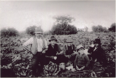
Photograph, Black & White, V Peterson E Boundary Rd E Bentleigh market garden c1925, Original c1925
The Peterson family were early settlers in Moorabbin Shire and established a market garden in East Boundary Road East Bentleigh. Vic Peterson - waistcoat, with Dick Marriott seated - ( brother in -law ), 2 unknown men and 7year old Geoff Peterson - Poliomyelitis as a baby- sitting in front with his walking sticks. The crop is cabbages that would be harvested and sent to the Melbourne markets.The early settlers like the Petersons and Marriotts, in the Parish of Moorabbin County of Bourke after Henry Dendy's Special Survey Brighton 1841, established market gardens, fruit & flower gardens, poultry & dairy farms, vineyards as well as shop businesses, blacksmiths, chemists, nursing homes and schools & Churches.Black & White photograph of Vic Peterson and 3 men & boy on his market garden in East Boundary Road East Bentleigh c1925 re-digitised 2005back ; handwritten information unsignedwagons, vulcan trucks, draught horses,, peterson vic, marriott dick, cabbage crops, vegetable crops, poliomyelitis epidemics 20thc , elster creek, plateways moorabbin shire, smith j l; smith mary ann, stanley helen, smith vic, smith harry redvers, chaff cutter, horse drawn carts, toll gates brighton, motor cars 1900, steam engines, early settlers, bentleigh, mckinnon, parish of moorabbin, city of moorabbin, county of bourke, moorabbin roads board, shire of moorabbin, henry dendy's special survey 1841, were j.b.; bent thomas, o'shannassy john, king richard, charman stephen, highett william, ormond francis, maynard dennis, market gardeners, vineyards, orchards -
 City of Moorabbin Historical Society (Operating the Box Cottage Museum)
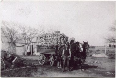
Photograph, Black & White, V Peterson East Boundary Rd East Bentleigh loaded wagon c1900, original c1900
The Peterson family were early settlers in Moorabbin Shire and established a market garden in East Boundary Road East Bentleigh. Vic Peterson and family loaded the crop - cabbages - onto the horse drawn wagon and set off to the Melbourne market using the Plateways that ran along Centre Road and Nepean Highway. The early settlers like the Petersons , in the Parish of Moorabbin County of Bourke after Henry Dendy's Special Survey Brighton 1841, established market gardens, fruit & flower gardens, poultry & dairy farms, vineyards as well as shop businesses, blacksmiths, chemists, nursing homes and schools & Churches.Black & White photograph showing Vic Peterson beside the horse drawn wagon loaded with 35dozen ( 12x 35) cabbages setting off to market c 1900 Original re-digitised by H Stanley 2005Back Hand written informationwagons, vulcan trucks, draught horses,, peterson vic, marriott dick, cabbage crops, vegetable crops, poliomyelitis epidemics 20thc , elster creek, plateways moorabbin shire, smith j l; smith mary ann, stanley helen, smith vic, smith harry redvers, chaff cutter, horse drawn carts, toll gates brighton, motor cars 1900, steam engines, early settlers, bentleigh, mckinnon, parish of moorabbin, city of moorabbin, county of bourke, moorabbin roads board, shire of moorabbin, henry dendy's special survey 1841, were j.b.; bent thomas, o'shannassy john, king richard, charman stephen, highett william, ormond francis, maynard dennis, market gardeners, vineyards, orchards -
 Bendigo Historical Society Inc.
Map - VICTORIA HILL - MAP - HAPPY VALLEY RD - DARE ST
Small map showing some blocks of land in the Happy Valley Road, Dare Street and Wells Streets area. Three of the blocks are in the name of Rae.map, bendigo, victoria hill, victoria hill, victoria hill - map - happy valley road - dare street, w rae, j rae -
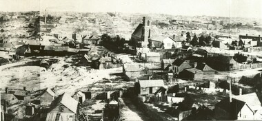
 Ballaarat Mechanics' Institute (BMI Ballarat)
Part of Panorama Main Rd Ballarat East
This photograph is from the Max Harris Collection held by the Ballaraat Mechanics' Institute. Please contact BMI for all print and usage inquiries.ballarat, main -
 Ballaarat Mechanics' Institute (BMI Ballarat)
Part of Panorama Main Rd Ballarat East
This photograph is from the Max Harris Collection held by the Ballaraat Mechanics' Institute. Please contact BMI for all print and usage inquiries.ballarat, main -
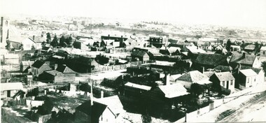
 Ballaarat Mechanics' Institute (BMI Ballarat)
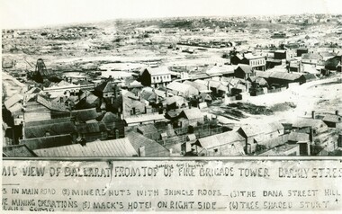
Part of Panorama Main Rd Ballarat East from East Fire Station Tower
This photograph is from the Max Harris Collection held by the Ballaraat Mechanics' Institute. Please contact BMI for all print and usage inquiries.ballarat, main, fire station tower -
 Ballaarat Mechanics' Institute (BMI Ballarat)
Part of Panorama Main Rd Ballarat East from East Fire Station Tower
This photograph is from the Max Harris Collection held by the Ballaraat Mechanics' Institute. Please contact BMI for all print and usage inquiries.ballarat, main, fire station tower -
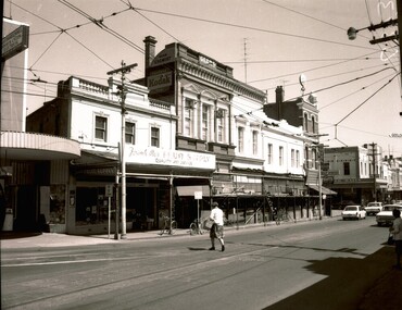 Ballaarat Mechanics' Institute (BMI Ballarat)
Bridge St looking west from Main Rd
1960s, ballarat, bridge st -
 Bendigo Historical Society Inc.
Photograph - GOLDEN SQUARE HIGH SCHOOL COLLECTION: LOOKING FROM MCDOUGALL RD
Photograph. GSHS, looking from Mcdougall road. -
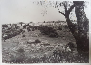 Darebin Parklands Association
Darebin Parklands looking toward Yarana rd, Rockbeare Park Conservation Group, 1973-1975
B&W photograph. Annotated on back with [Mulberry spur showing neglect and weeds]. -
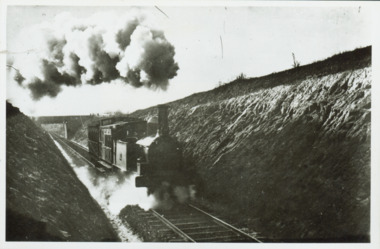 Kew Historical Society Inc
Photograph - Train coming up grade beyond Barnsbury Rd, Deepdene 1905
The Outer Circle Railway was opened in stages in 1890 and 1891, as a steam-era suburban railway line. It traversed much of the modern City of Boroondara, including the suburbs of (from north to south) Kew East, Camberwell, Burwood, Ashburton, and Malvern East. At its longest, it ran from Fairfield station, on what is today the Hurstbridge line, to Oakleigh station, on the current Pakenham and Cranbourne lines.Steam train in a cutting on the Outer Circle Railway line. Exhibition enlargement donated by Stewart West from an original owned by Miss Foley.trains, outer circle railway -
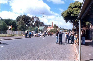 Tarnagulla History Archive
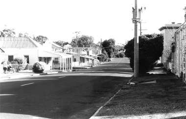
Photograph: View down Commercial Rd, Tarnagulla during a public event
David Gordon Collection. -
 Tarnagulla History Archive
Photograph: View down Commercial Rd, Tarnagulla during a public event
David Gordon Collection. -
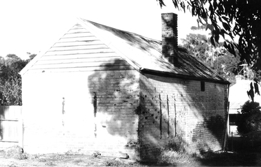
 Tarnagulla History Archive
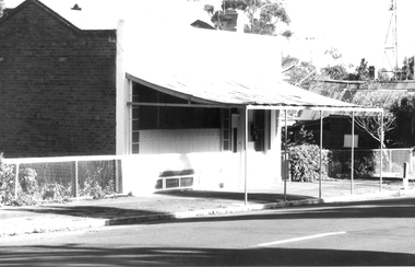
Photograph: Building formerly at 107 Commercial Rd, Tarnagulla
David Gordon Collection. -
 Tarnagulla History Archive
Photograph: Building formerly at 107 Commercial Rd, Tarnagulla
David Gordon Collection. -
 Tarnagulla History Archive
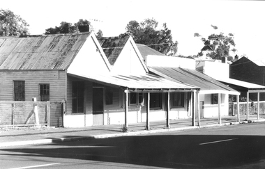
Photograph: 83, 85 & 87 Commercial Rd, Tarnagulla
David Gordon Collection. -
 Tarnagulla History Archive
Photograph: Shopfront with verandah, 81 Commercial Rd, Tarnagulla
David Gordon Collection. -
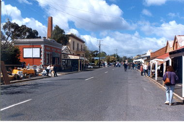
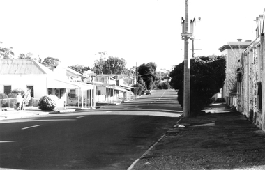
 Tarnagulla History Archive
Photograph: Commercial Rd, Tarnagulla
David Gordon Collection. -
 Tarnagulla History Archive
Photograph: Commercial Rd, Tarnagulla
David Gordon Collection. -
 Tarnagulla History Archive
Photograph: Rear view of a brick building on Commercial Rd, Tarnagulla
David Gordon Collection. -
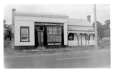 Tarnagulla History Archive
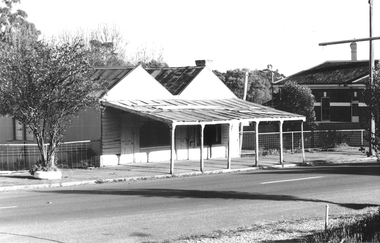
Photograph of Bowman's Bakery building, at 64 Commercial Rd, Tarnagulla, Bowman's Bakery building, Tarnagulla, Late 1960s
Murray Comrie Collection. Still located at the north end of Commercial Road, Tarnagulla.Monochrome photograph depicting building once used as G.Bowman's shopfront and adjacent dwelling in Tarnagulla.tarnagulla, commercial road, commerce, shopfronts, shops, businesses, bakery, food, stockfeed, grains, agriculture -
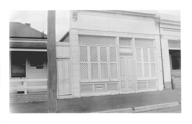 Tarnagulla History Archive
Photograph of latticed shopfront at 98 Commercial Rd, Tarnagulla, Late 1960s
Murray Comrie Collection. Building is still on Commercial Road and in 2019 is a private residence. History to be confirmed.Monochrome photograph depicting a latticed shopfront, which is located at 98 Commercial Road, Tarnagulla. Small portion of building visible at far right was demolished in the 1990s.tarnagulla, commercial road, buildings, houses -
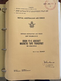 Moorabbin Air Museum
Manual (item) - (SP) AAP 7215.004-2-5-13 Lockheed P-3C Orion Magnetic Tape Transport RD 319A/AYA=8
Lockheed Orion Aircraft -
 Bendigo Historical Society Inc.
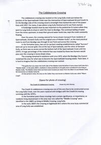
Document - The Cobblestone Crossing, 2/11/2023
A cobblestone crossing was established across Long Gully Creek near current Creeth Street. The crossing provided horse-drawn vehicles from Sparrowhawk, Derwent Gully and the original Maiden Gully to Long Gully.A 3 page document on Sparrowhawk Rd, the old Cobblestone crossing and the long lost sights of the surrounding area. john harvey, long gully, sparrowhawk rd, creeth st -
 Melbourne Tram Museum
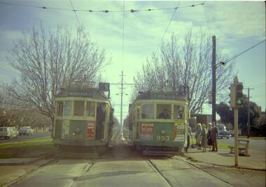
Negative, Travis Jeffrey, 10/06/1962 12:00:00 AM
Colour negative of trams 514 and 953 in Dandenong Road. Tram 514 has destination Malvern - Burke Rd and Route No 5. Photo shows tram on the left track (city-bound), although facing towards its destination (Malvern). Driver standing in door of cab and conductor standing in doorway to tram. Tram 953 has destination East Brighton via Caulfield and Route No 64. Sign on front states: "Connect with Malvern-Burke Rd tram".Paper folder that contained the negative had "NR75B" and date written as 10 Jun 62 in red ink.trams, tramways, w2 class, route 5, route 64, dandenong rd, wattle tree rd, malvern burke rd, tram 514, tram 953 -
 St Kilda Historical Society
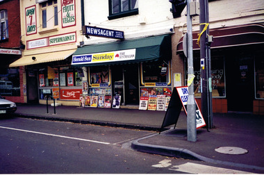
Photograph, November 1996
Shows newsagent, Lebanese food shop, Supermarket 'open 7 days'colour photograph unmountedNewsagent Ormond Rd Elwoodelwood, ormond road, 1996, elwood shops, newsagents -
Bendigo Historical Society Inc.
Map - SANDHURST (PART), Circa 1880's
Map: Parish plan sowing an area along Specimen Hill Rd. ( number 211 in Map Cupboard 1)map, bendigo, parish plan, specimen hill rd. sandhurst , bendigo -
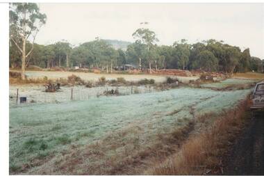 Buninyong & District Historical Society
Photograph - Original Colour Photo, "Wiseman's" Wood Yard, Yendon No. 1 Road, Buninyong, September 1994
Rural industryColour phot, "Wiseman's" Wood Yard, Yendon No. 1 Road, Buninyong (near intersection of Yendon No.2 Rd.)landscape, woodyard, mt. buninyong, yendon no.1 rd -
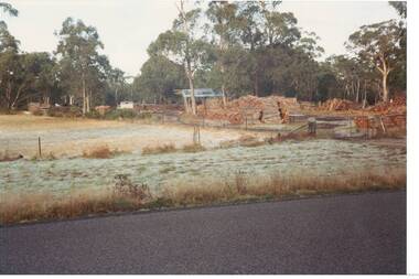 Buninyong & District Historical Society
Photograph - Original Colour Photo, "Wiseman's" Wood Yard, Yendon No. 1 Road, Buninyong, September 1994
Rural industryColour phot, "Wiseman's" Wood Yard, Yendon No. 1 Road, Buninyong (near intersection of Yendon No.2 Rd.)landscape, woodyard, mt. buninyong, yendon no.1 rd