Showing 7053 items matching " station street"
-
 Marysville & District Historical Society
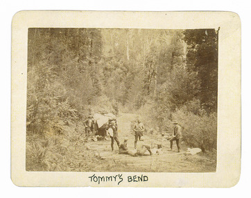
Photograph (Item) - Black and white photograph, Tommy's Bend, c1900
... ARMSTRONG COLLECTION 42 STATION STREET/ SANDRINGHAM 3191... road ARMSTRONG COLLECTION 42 STATION STREET/ SANDRINGHAM 3191 ...An early black and white photograph taken at Tommy's Bend near Marysville in Victoria.An early black and white photograph taken at Tommy's Bend near Marysville in Victoria. Tommy's Bend is a stretch of road 10 kilometres from Marysville on the Woods Point Road up to Lake Mountain. This road was originally constructed as a corduroy road (or log road) is a type of road or timber trackway made by placing logs, perpendicular to the direction of the road over a low or swampy area. The result is an improvement over impassable mud or dirt roads, yet rough in the best of conditions and a hazard to horses due to shifting loose logs.ARMSTRONG COLLECTION 42 STATION STREET/ SANDRINGHAM 3191/ TEL. (03) 9521 5442/ IAN M.L. ARMSTRONG OAMtommy's bend, marysville, victoria, marysville-wood's point road, corduroy road -
 Marysville & District Historical Society
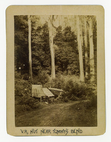
Photograph (Item) - Black and white photograph, V.R. Hut near Tommy's Bend, c1900
... ARMSTRONG COLLECTION 42 STATION STREET/ SANDRINGHAM 3191... road ARMSTRONG COLLECTION 42 STATION STREET/ SANDRINGHAM 3191 ...An early black and white photograph of a Victoria Roads worker's hut near Tommy's Bend near Marysville in Victoria. An early black and white photograph of a Victoria Roads worker's hut near Tommy's Bend near Marysville in Victoria. Tommy's Bend is a stretch of road 10 kilometres from Marysville on the Woods Point Road up to Lake Mountain.ARMSTRONG COLLECTION 42 STATION STREET/ SANDRINGHAM 3191/ TEL. (03) 9521 5442/ IAN M.L. ARMSTRONG OAMtommy's bend, marysville, victoria, marysville-wood's point road -
 Marysville & District Historical Society
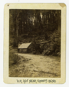
Photograph (Item) - Black and white photograph, V.R. Hut near Tommy's Bend, c1900
... ARMSTRONG COLLECTION 42 STATION STREET/ SANDRINGHAM 3191... road ARMSTRONG COLLECTION 42 STATION STREET/ SANDRINGHAM 3191 ...An early black and white photograph of a Victoria Roads worker's hut near Tommy's Bend near Marysville in Victoria. An early black and white photograph of a Victoria Roads worker's hut near Tommy's Bend near Marysville in Victoria. Tommy's Bend is a stretch of road 10 kilometres from Marysville on the Woods Point Road up to Lake Mountain.ARMSTRONG COLLECTION 42 STATION STREET/ SANDRINGHAM 3191/ TEL. (03) 9521 5442/ IAN M.L. ARMSTRONG OAMtommy's bend, marysville, victoria, marysville-wood's point road -
 Marysville & District Historical Society
Photograph (Item) - Black and white photograph, Beech Forest Beyond Tommy's Bend, c1900
... ARMSTRONG COLLECTION 42 STATION STREET/ SANDRINGHAM 3191... reginald talbot ARMSTRONG COLLECTION 42 STATION STREET/ SANDRINGHAM ...An early black and white photograph of The Beeches, which is known as the Beech Grove, near Tommy's Bend near Marysville in Victoria.An early black and white photograph of The Beeches, which is known as the Beech Grove, near Tommy's Bend near Marysville in Victoria. Tommy's Bend is a stretch of road 10 kilometres from Marysville on the Wood's Point Road up to Lake Mountain. The Beeches Rainforest Walk is a loop that starts at Taggerty Cascades before winding through Myrtle Beech and Mountain Ash woodland and is one of the many walking tracks in and around Marysville. It is accessible from Lady Talbot Drive which is a 24 kilometer scenic rainforest car journey which passes a number of walks and waterfalls in the Yarra Ranges National Park. Lady Talbot Drive is named after Lady Sarah Elizabeth, the wife of Sir Reginald Talbot, who was the Governor of Victoria from 25th April, 1904 to 6th July 1908.ARMSTRONG COLLECTION 42 STATION STREET/ SANDRINGHAM 3191/ TEL. (03) 9521 5442/ IAN M.L. ARMSTRONG OAMtommy's bend, marysville, victoria, marysville-wood's point road, beech grove, wood's point road, lake mountain, beeches rainforest walk, taggerty cascades, myrtle beech, mountain ash, lady talbot drive, lady talbot forest drive, lady sarah elizabeth talbot, sir reginald talbot -
 Marysville & District Historical Society
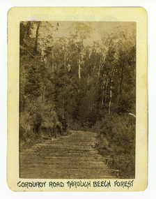
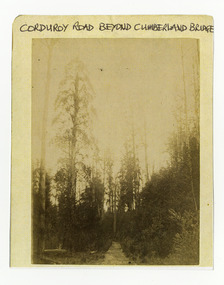
Photograph (Item) - Black and white photograph, Corduroy Road Through Beech Forest, c1900
... ARMSTRONG COLLECTION 42 STATION STREET/ SANDRINGHAM 3191... 42 STATION STREET/ SANDRINGHAM 3191/ TEL. (03) 9521 5442/ IAN ...An early black and white photograph of a corduroy road running through the forest near Marysville in Victoria.An early black and white photograph of a corduroy road running through the forest near Marysville in Victoria. A corduroy road (or log road) is a type of road or timber trackway made by placing logs, perpendicular to the direction of the road over a low or swampy area. The result is an improvement over impassable mud or dirt roads, yet rough in the best of conditions and a hazard to horses due to shifting loose logs.ARMSTRONG COLLECTION 42 STATION STREET/ SANDRINGHAM 3191/ TEL. (03) 9521 5442/ IAN M.L. ARMSTRONG OAMcorduroy road, marysville, victoria, beech forest -
 Marysville & District Historical Society
Photograph (Item) - Black and white photograph, Bridge Over The Cumberland, c1900
... ARMSTRONG COLLECTION 42 STATION STREET/ SANDRINGHAM 3191... STATION STREET/ SANDRINGHAM 3191/ TEL. (03) 9521 5442/ IAN M.L ...An early black and white photograph of a bridge over the Cumberland Creek near Marysville in Victoria.An early black and white photograph of a bridge over the Cumberland Creek near Marysville in Victoria. The Cumberland Creek is in the Cumberland Valley near Cambarville which was a timber town near Marysville. Cambarville is notable for its giant mountain ash (Eucalyptus regnans) trees within the Cumberland Memorial Scenic Reserve, and relics from former sawmills and gold mining. The Big Culvert is located nearby on the Marysville - Woods Point Road, which was historically part of the Yarra Track. Cambarville was established as a timber mill town in the 1940s. Timber mill owners A Cameron and FJ Barton named Cambarville. They established the mill to salvage timber from trees destroyed in the 1939 bushfires. Cambarville was impacted by the 2009 Black Saturday bushfires and any remaining structures were destroyed.ARMSTRONG COLLECTION 42 STATION STREET/ SANDRINGHAM 3191/ TEL. (03) 9521 5442/ IAN M.L. ARMSTRONG OAMcumberland creek, marysville, victoria, cumberland valley, cambarville, mountain ash, eucalyptus regnans, cumberland memorial reserve, the big culvert, marysville-wood's point road, yarra track, a cameron, fj barton, 2009 black saturday bushfires -
 Marysville & District Historical Society
Photograph (Item) - Black and white photograph, Corduroy Road Beyond Cumberland Bridge, c1900
... ARMSTRONG COLLECTION 42 STATION STREET/ SANDRINGHAM 3191.... corduroy road marysville victoria ARMSTRONG COLLECTION 42 STATION ...An early black and white photograph of a corduroy road running through the forest near Marysville in Victoria.An early black and white photograph of a corduroy road running through the forest near Marysville in Victoria. A corduroy road (or log road) is a type of road or timber trackway made by placing logs, perpendicular to the direction of the road over a low or swampy area. The result is an improvement over impassable mud or dirt roads, yet rough in the best of conditions and a hazard to horses due to shifting loose logs.ARMSTRONG COLLECTION 42 STATION STREET/ SANDRINGHAM 3191/ TEL. (03) 9521 5442/ IAN M.L. ARMSTRONG OAMcorduroy road, marysville, victoria -
 Marysville & District Historical Society
Photograph (Item) - Black and white photograph, Way to Cumberland Falls, c1900
... ARMSTRONG COLLECTION 42 STATION STREET/ SANDRINGHAM 3191... eucalyptus regnans ARMSTRONG COLLECTION 42 STATION STREET ...An early black and white photograph of the forest near the Cumberland Falls in Victoria.An early black and white photograph of the forest near the Cumberland Falls in Victoria. The falls are located on the Marysville-Wood's Point Road. Cambarville is notable for its giant mountain ash (Eucalyptus regnans) trees within the Cumberland Memorial Scenic Reserve, and relics from former sawmills and gold mining. The Big Culvert is located nearby on the Marysville - Woods Point Road, which was historically part of the Yarra Track. Cambarville was established as a timber mill town in the 1940s. Timber mill owners A Cameron and FJ Barton named Cambarville. They established the mill to salvage timber from trees destroyed in the 1939 bushfires. Cambarville was impacted by the 2009 Black Saturday bushfires and any remaining structures were destroyed.ARMSTRONG COLLECTION 42 STATION STREET/ SANDRINGHAM 3191/ TEL. (03) 9521 5442/ IAN M.L. ARMSTRONG OAMcumberland falls, cambarville, marysville, victoria, waterfalls, postcard, souvenir, mountain ash, mining, timber mills, big culvert, yarra track, a cameron, fj barton, black saturday bushfires, 1939 bushfires, eucalyptus regnans -
 Marysville & District Historical Society
Photograph (Item) - Black and white photograph, Cumberland Falls, c1900
... ARMSTRONG COLLECTION 42 STATION STREET/ SANDRINGHAM 3191... eucalyptus regnans ARMSTRONG COLLECTION 42 STATION STREET ...An early black and white photograph of Cumberland Falls near Marysville in Victoria.An early black and white photograph of Cumberland Falls near Marysville in Victoria. These falls are located on the Marysville-Wood's Point Road. Cambarville is notable for its giant mountain ash (Eucalyptus regnans) trees within the Cumberland Memorial Scenic Reserve, and relics from former sawmills and gold mining. The Big Culvert is located nearby on the Marysville - Woods Point Road, which was historically part of the Yarra Track. Cambarville was established as a timber mill town in the 1940s. Timber mill owners A Cameron and FJ Barton named Cambarville. They established the mill to salvage timber from trees destroyed in the 1939 bushfires. Cambarville was impacted by the 2009 Black Saturday bushfires and any remaining structures were destroyed.ARMSTRONG COLLECTION 42 STATION STREET/ SANDRINGHAM 3191/ TEL. (03) 9521 5442/ IAN M.L. ARMSTRONG OAMcumberland falls, cambarville, marysville, victoria, waterfalls, postcard, souvenir, mountain ash, mining, timber mills, big culvert, yarra track, a cameron, fj barton, black saturday bushfires, 1939 bushfires, eucalyptus regnans -
 Marysville & District Historical Society
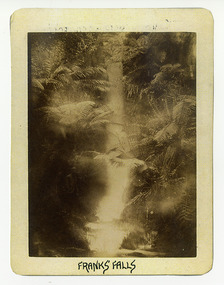
Photograph (Item) - Black and white photograph, Franks' Falls, c1900
... ARMSTRONG COLLECTION 42 STATION STREET/ SANDRINGHAM 3191... of these falls. franks' falls ARMSTRONG COLLECTION 42 STATION STREET ...An early black and white photograph of Franks' Falls.An early black and white photograph of Franks' Falls. Unable to ascertain location of these falls.ARMSTRONG COLLECTION 42 STATION STREET/ SANDRINGHAM 3191/ TEL. (03) 9521 5442/ IAN M.L. ARMSTRONG OAMfranks' falls -
 Marysville & District Historical Society
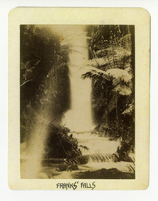
Photograph (Item) - Black and white photograph, Franks' Falls, c1900
... ARMSTRONG COLLECTION 42 STATION STREET/ SANDRINGHAM 3191... of these falls. franks' falls ARMSTRONG COLLECTION 42 STATION STREET ...An early black and white photograph of Franks' Falls.An early black and white photograph of Franks' Falls. Unable to ascertain location of these falls.ARMSTRONG COLLECTION 42 STATION STREET/ SANDRINGHAM 3191/ TEL. (03) 9521 5442/ IAN M.L. ARMSTRONG OAMfranks' falls -
 Marysville & District Historical Society
Photograph (Item) - Black and white photograph, Yarra Track Hotel, c1900
... ARMSTRONG COLLECTION 42 STATION STREET/ SANDRINGHAM 3191... marysville cumberland creek ARMSTRONG COLLECTION 42 STATION STREET ...An early black and white photograph of a hotel along the Yarra Track.An early black and white photograph of a hotel along the Yarra Track. The Yarra Track is the former name of the gold fields road from Healesville to the Woods Point and Jordan Goldfields, in Victoria, Australia. A direct route via the Yarra River and the Great Divide was discovered by Rieck in September 1862 and became known as the Yarra Track. Early in 1863, the Victorian Government decided to construct a 193-kilometre (120 mile) road along the route. Its original width varied between 4 and 6 metres (12 and 20 feet), and was designed to accommodate horse-drawn vehicles. The Track involved the climbing of the Black Spur, descent into the Acheron Valley, and then through Marysville to the Cumberland where it followed the existing route. Unable to ascertain both the location and name of hotel.ARMSTRONG COLLECTION 42 STATION STREET/ SANDRINGHAM 3191/ TEL. (03) 9521 5442/ IAN M.L. ARMSTRONG OAMyarra track, healesville, wood's point, jordan goldfields, victoria, yarra river, great divide, reick, black spur, acheron valley, marysville, cumberland creek -
 Marysville & District Historical Society
Photograph (Item) - Black and white photograph, The "Scandinavians' - (Deserted), c1900
... ARMSTRONG COLLECTION 42 STATION STREET/ SANDRINGHAM 3191... COLLECTION 42 STATION STREET/ SANDRINGHAM 3191/ TEL. (03) 9521 5442 ...An early black and white photograph of The Scandinavian's Hotel and Boarding House along the Yarra Track.An early black and white photograph of The Scandinavian's Hotel and Boarding House along the Yarra Track. The Yarra Track is the former name of the gold fields road from Healesville to the Woods Point and Jordan Goldfields, in Victoria, Australia. A direct route via the Yarra River and the Great Divide was discovered by Rieck in September 1862 and became known as the Yarra Track. Early in 1863, the Victorian Government decided to construct a 193-kilometre (120 mile) road along the route. Its original width varied between 4 and 6 metres (12 and 20 feet), and was designed to accommodate horse-drawn vehicles. The Track involved the climbing of the Black Spur, descent into the Acheron Valley, and then through Marysville to the Cumberland where it followed the existing route.ARMSTRONG COLLECTION 42 STATION STREET/ SANDRINGHAM 3191/ TEL. (03) 9521 5442/ IAN M.L. ARMSTRONG OAMthe scandinavians', yarra track, healesville, wood's point, jordan goldfields, victoria, yarra river, great divide, reick, black spur, acheron valley, marysville, cumberland creek -
 Marysville & District Historical Society
Photograph (Item) - Black and white photograph, Camp Opposite The "Scandinavians', c1900
... ARMSTRONG COLLECTION 42 STATION STREET/ SANDRINGHAM 3191... COLLECTION 42 STATION STREET/ SANDRINGHAM 3191/ TEL. (03) 9521 5442 ...An early black and white photograph of a camp which was opposite The Scandinavian's Hotel and Boarding House along the Yarra Track.An early black and white photograph of a camp which was opposite The Scandinavian's Hotel and Boarding House along the Yarra Track. The Yarra Track is the former name of the gold fields road from Healesville to the Woods Point and Jordan Goldfields, in Victoria, Australia. A direct route via the Yarra River and the Great Divide was discovered by Rieck in September 1862 and became known as the Yarra Track. Early in 1863, the Victorian Government decided to construct a 193-kilometre (120 mile) road along the route. Its original width varied between 4 and 6 metres (12 and 20 feet), and was designed to accommodate horse-drawn vehicles. The Track involved the climbing of the Black Spur, descent into the Acheron Valley, and then through Marysville to the Cumberland where it followed the existing route.ARMSTRONG COLLECTION 42 STATION STREET/ SANDRINGHAM 3191/ TEL. (03) 9521 5442/ IAN M.L. ARMSTRONG OAMthe scandinavians', yarra track, healesville, wood's point, jordan goldfields, victoria, yarra river, great divide, reick, black spur, acheron valley, marysville, cumberland creek -
 Greensborough Historical Society
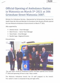
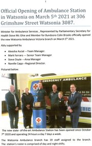
Document - Article, Rosie Bray, Official opening of ambulance station in Watsonia on March 5th 2021, 07/03/2021
... , of the new ambulance station at 306 Grimshaw Street Watsonia... Grimshaw Street Watsonia ambulance station watsonia grimshaw street ...Account of the opening, and background to site selection, of the new ambulance station at 306 Grimshaw Street Watsonia3 p. typescript, colour photographs, with copies of photographs incorporated in the documentambulance station, watsonia, grimshaw street watsonia -
 Greensborough Historical Society
Document - Report, Rosie Bray, Official opening of ambulance station in Watsonia 2021, 2021
... Official opening of the ambulance station at 306 Grimshaw... station at 306 Grimshaw Street Watsonia took place on 5 March 2021 ...Official opening of the ambulance station at 306 Grimshaw Street Watsonia took place on 5 March 20212 p. typescript and colour photographsambulance station watsonia, grimshaw street watsonia, ambulance victoria -
 Melbourne Legacy
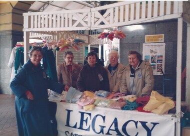
Photograph - Photo, Legacy Appeal, Badge Week Stall, 1990
... Street Station in 1990. Widows met regularly at Legacy House...Colour photo x 2 of widows selling items at Flinders Street... Street Station in 1990. Widows met regularly at Legacy House ...Two photos of widows with a handcrafts stall at Flinders Street Station in 1990. Widows met regularly at Legacy House for craft gatherings lessons. Some of the items the Widows produced were entered into an annual craft contest and exhibition. Many items were also donated to the annual Badge Week stall that widows organised. The stall was often outside Legacy House but in these photos from 1990 the stall was set up at Flinders Street Station. The ladies names aren't known.A record of the fundraising for the Legacy Appeal in 1990 by the widows clubs.Colour photo x 2 of widows selling items at Flinders Street Station in 1990.legacy appeal, fundraising, badge week, widows, craft -
 Melbourne Tram Museum
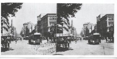
Photograph - Set of three images from stereo pairs, c1900
... Flinders Street station... Melbourne stereo pairs Flinders Street station Collins Street ...Set of three images from stereo pairs - not all complete.Yields information about Melbourne cable trams.Set of three stereo pairs - not complete 1 - Collins St 2 - Swanston St 3 - Part of a stereo pair – Flinders St StationOn rear of prints in ink. 2 - Melbourne – Swanston St (north from Collins St) - Copy neg Mark Plummer collections ex late John Alfred collection. 3 - Melbourne - Flinders St over cnr Swanston St with the (then) new Flinders St Station. Copy neg Mark Plummer collections ex late John Alfred collection. cable trams, tramways, melbourne, stereo pairs, flinders street station, collins street, swanston street -
 Port Melbourne Historical & Preservation Society
Photograph - Demolition, 225 Princes Street, Port Melbourne, Pat Grainger
... of 70 Station Street... Street through to the back of 70 Station Street Photograph ...225 Princes Street was sold and demolished after its owner, Ted Young, was brutally murdered there (multiple stabbing). Police thought they knew who did it but had no evidence. Wall of Milk Bar across Princes Street was subsequently demolished.One of three colour photos of 225 Princes Street following demolition (2000?): .01 View from Princes Street through to the back of 70 Station StreetSome notes in pencilbuilt environment - domestic, demolitions, crimes and misdemeanours, edward (ted) young -
 Whitehorse Historical Society Inc.
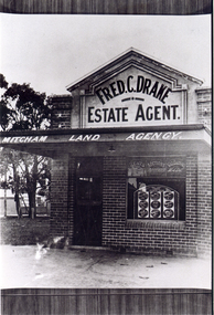
Photograph, Fred Drake Office
... of Station Street and Colombo Street, Mitcham (later Drake... of Station Street and Colombo Street, Mitcham (later Drake ...Black/white - Fred Drake Real Estate Offices on Corner of Station Street and Colombo Street, Mitcham (later Drake and Company later principal Norman Armstrong.)drake, fred, real estate agents, armstrong, ian -
 Chelsea & District Historical Society Inc
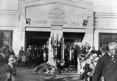
Photograph - Borough of Carrum Memorial Hall, Unveiling of the Memorial Cenotaph, 3 April 1927
... of the Carrum Memorial Hall, situated in Station Street, Chelsea.The... in Station Street, Chelsea.The cenotaph has three flags with floral ...The Carrum Memorial Hall was opened on 5 December 1925. In 1929 the name was changed to Chelsea Memorial Hall when Chelsea was proclaimed a city. The building was in use until 1963. The unveiling of the cenotaph Chelsea by Gen. H. E. "Pompey" Elliot. Photo taken by Comrade R. Monett whilst the crowd was still in attendance. Attended by Rev. J.R. Mappin, Church of England, Edithvale assisted by Rev. Pastor McOrmish Congregational, Mr Collins Presbyterian Edithvale and Commandant Lucas Salvation Army.A black and white photo of people standing in front of the Carrum Memorial Hall, situated in Station Street, Chelsea.The cenotaph has three flags with floral arrangements at the base.borough of carrum memorial hall, chelsea memorial hall, chelsea -
 Vision Australia
Photograph - Image, Thomas Kane, 2008 International White Cane Day at Flinders St Station and Southbank, 15/10/2008
... Flinders Street Station... met at the Travellers Aid office at Flinders Street station... at the Travellers Aid office at Flinders Street station, before walking down ...To celebrate White Cane Day in 2008, a group of cane users met at the Travellers Aid office at Flinders Street station, before walking down the escalators, along the platform and along the Yarra River and St Kilda Road at Southbank.98 digital images of people participating in the 2008 White Cane Day eventvision australia, white cane day, cath caddis, tracy wright, kylie gerson, nicola misso, di seybold, flinders street station -
Port Melbourne Historical & Preservation Society
Photograph - Bridge Street, Then and Now series, David Thompson, 1996
... "Bridge St - Then and Now" series. Bridge street, taken... lanes and footpaths david thompson bridge street station hotel ...Taken 1996 by David Thompson for "Then and Now""Bridge St - Then and Now" series. Bridge street, taken from near the tram crossing, looking towards Bay Street. Shows Station Hotel building, which had been converted into a private residence. (no 587 from series)built environment - commercial, built environment - domestic, engineering - roads streets lanes and footpaths, david thompson, bridge street, station hotel -
Port Melbourne Historical & Preservation Society
Photograph - Friends of the Park float, Port Melbourne Festival, Pat Grainger, Feb 1989
... at Station Street carport, 88 Ingles Street: Jan Fly and ?... Port Melbourne Festival: Float construction at Station Street ...This float was created by members of Friends of the Park, a group formed in 1987 against government proposals to turn the railway and reservation into a grand boulevard to service the proposed Sandridge City 'Bayside' development. Members worked for months to make the decorations, added to a trailer. During the festival procession sausages were BBQ'd on the trailer and handed out to the crowd. On arrival at Murphy's Reserve all floats were put out of sight, and few saw the results of their efforts.One of 16 photos of Friends of the Park float for the February 1988 Port Melbourne Festival: Float construction at Station Street carport, 88 Ingles Street: Jan Fly and ?celebrations fetes and exhibitions, public action campaigns, town planning - proposals shelved - bayside, jan fly, friends of the park, port melbourne festival -
Port Melbourne Historical & Preservation Society
Photograph - Friends of the Park float, Port Melbourne Festival, Pat Grainger, Feb 1989
... at Station Street carport - Jemma and Marilyn Tulloch with flower... Festival: Float construction at Station Street carport - Jemma ...This float was created by members of Friends of the Park, a group formed in 1987 against government proposals to turn the railway and reservation into a grand boulevard to service the proposed Sandridge City 'bayside' development. Members worked for months to make the decorations, added to a trailer. During the festival procession sausages were BBQ'd on the trailer and handed out to the crowd. On arrival at Murphy's Reserve all floats were put out of sight, and few saw the results of their efforts.One of 16 photos of Friends of the Park float for the February 1989 Port Melbourne Festival: Float construction at Station Street carport - Jemma and Marilyn Tulloch with flower decorationscelebrations fetes and exhibitions, public action campaigns, gemma tulloch, marilyn tulloch, friends of the park, port melbourne festival -
 Whitehorse Historical Society Inc.
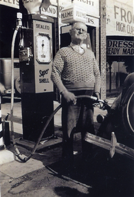
Photograph, Mitcham service station
... of Station Street. (Proprietor Mr. Kerr) Original on CDROM... Mitcham. It is thought to have been located west of Station Street ...Black and white photograph of petrol service station in Whitehorse Road Mitcham. It is thought to have been located west of Station Street. (Proprietor Mr. Kerr) Original on CDROMservice stations, whitehorse road, mitcham -
Port Melbourne Historical & Preservation Society
Document - 2004 Calendar, Pat Grainger, Around the streets of Historic Port Melbourne, Oct 2003
... 2004: men in Station Street on cover, sepia on ivory All... 2004: men in Station Street on cover, sepia on ivory All ...Researched, written and designed by member Pat GRAINGER as a fundraiser for PMH&PS. Production volume: 700 copiesAround the streets of .Historic Port Melbourne calendar 2004: men in Station Street on cover, sepia on ivory All following years calendars also recorded against cat no 1864transport - railways, transport - motor vehicles, sandridge lagoon, swallow street, clark street, cruikshank street, faram brothers hardware, ted keogh, marlene keogh, boundary rovers football club, mission to seafarers, gasworks