Showing 659 items matching " survey plan"
-
 Bendigo Historical Society Inc.
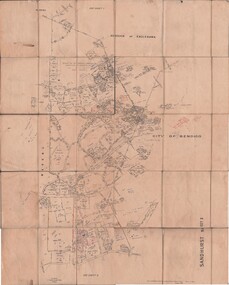
Map - JACK FLYNN COLLECTION: SANDHURST SHEET 2, January 1947
Map: Parish of Sandhurst Sheet 2, County of Bendigo. Parish plan.By Authority J. J. Gourley, Government Printer, Melbourne. Drawn and Reproduced at the Dept, of Lands and Survey, Melbourne, Victoria.map, bendigo, parish plan, sandhurst sheet 2 -
 Bendigo Historical Society Inc.
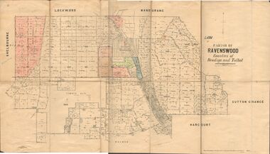
Map - JACK FLYNN COLLECTION: RAVENSWOOD, 12/12/1922
Map: Parish of Ravenswood, Counties of Bendigo and Talbot. Parish plan.By Authority A.J. Mullet Government Printer Melbourne. Photo Lithographed at the Department of lands and Survey, Melbourne by W.J. Butsonmap, bendigo, parish plan, ravenswood -
 Bendigo Historical Society Inc.
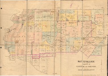
Map - JACK FLYNN COLLECTION: NATTE YALLOCK, 22/06/1937
Map: Parish of Natte Yallock, Counties of Gladstone and Kara Kara. Parish plan.By Authority H.J. Green Government Printer Melbourne. Drawn and Reproduced at the Depart., of Lands and Survey, Melbourne, Victoria.map, gladstone, parish plan, natte yallock -
 Bendigo Historical Society Inc.
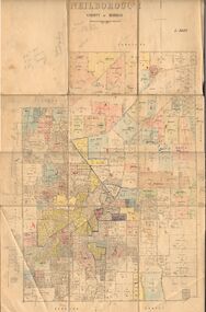
Map - JACK FLYNN COLLECTION: NEILBOROUGH, 13/10/1927
Map: Parish of Neilborough, County of Bendigo. Parish plan.Photo Lithographed at the Department of Lands and Survey, Melbourne by W.J. Butsonmap, bendigo, parish plan, neilborough -
 Bendigo Historical Society Inc.
Map - JACK FLYNN COLLECTION: MUSKERRY, 1962
Map: Parish of Muskerry, County of Rodney. Parish plan.By Authority: A.C. Brooks, Government Printer, Melbourne. Drawn and reproduced at the Department of Lands and Survey, Melbournemap, rodney, parish plan, muskerry -
 Bendigo Historical Society Inc.
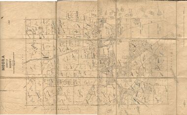
Map - JACK FLYNN COLLECTION: MOORA, 9/10/22
Map: Parish of Moora, County of Rodney. Parish plan.By Authority A.J. Mullet Government Printer Melbourne. Photo Lithographed at the Dept, of Lands and Survey, Melbourne by W.J. Butson. 3.10.22map, rodney, parish plan, moora -
 Bendigo Historical Society Inc.
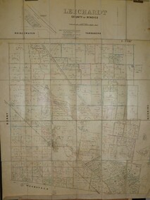
Map - JACK FLYNN COLLECTION: LEICHARDT, 14/03/1`939
Map: Parish of Leichardt, County of Bendigo. Parish plan.Drawn and Reproduced at the Dept, of Lands and Survey, Melbourne, Victoria. 14.3.1939map, bendigo, parish plan, leichardt -
 Bendigo Historical Society Inc.
Map - JACK FLYNN COLLECTION: HAYANMI, March 1953
Map: Parish of Hayanmi, County of Bendigo. Parish plan.By Authority: W.M. Houston, Government Printer. Drawn and reproduced at the Dept, of Lands and Survey, Melbourne, Victoriamap, bendigo, parish plan, hayanmi -
 Bendigo Historical Society Inc.
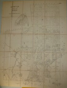
Map - JACK FLYNN COLLECTION: HUNTLY, 8/09/1921
Map: Parish of Huntly, County of Bendigo. Parish plan.By Authority, Govt., Printer. A. J. Mullett. Photo Lithographed at the Department of Land and Survey Melbourne By W. J. Butsonmap, bendigo, parish plan, huntly -
 Bendigo Historical Society Inc.
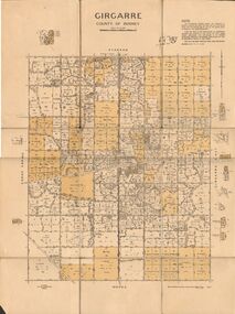
Map - JACK FLYNN COLLECTION: GIRGARRE, 14/10/1943
Map: Parish of Girgarre , County of Rodney. Parish plan. Same map as 10100.20 but in poorer condition.By Authority, H.E.Daw, Government printer Melbourne. Drawn and Reproduced at the Dept, of Lands and Survey, Melbourne, Victoriamap, rodney, girgarre, girgarre, county of rodney -
 Bendigo Historical Society Inc.
Map - JACK FLYNN COLLECTION: GIRGARRE, 14/10/1943
Map: Parish of Girgarre. County of Rodney. Parish plan.By Authority, H.E. Daw, Government Printer Melbourne. Drawn and produced at the Dept of Lands and Survey, Melbourne, Victoria. 14.10.1943map, rodney, parish plan, girgarre, county of rodney -
 Bendigo Historical Society Inc.
Map - JACK FLYNN COLLECTION: GIRGARRE, 1957
Map: Township of Girgarre, Parish of Kyabram, County of Rodney. Parish plan.By Authority: W. M. Houston, Government Printer, Melbourne. Drawn and reproduced at the Department of Lands and Survey, Melbourne.map, rodney, township, girgarre -
 Bendigo Historical Society Inc.
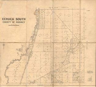
Map - JACK FLYNN COLLECTION: ECHUCA SOUTH, 13/08/1931
Map: Parish of Echuca South, County of Rodney. Parish plan.By Authority H. J. Green, Govt. Printer. Department of Lands and Survey, Melbourne. 13.8.31map, rodney, parish plan, echuca south , county of rodney -
 Bendigo Historical Society Inc.
Map - JACK FLYNN COLLECTION: EDDINGTON, 1.12.1925
Map: Parish of Eddington, Counties of Gladstone and Talbot. Parish plan.Dept of Lands and Survey Melbourne by W.J. Butson 1.12.25map, talbot, parish plan, eddington, counties of talbot, gladstone -
 Bendigo Historical Society Inc.
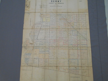
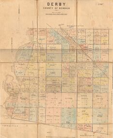
Map - JACK FLYNN COLLECTION: DERBY, 12/05/1892
Map: Derby, County of Bendigo. Parish plan.Department of Lands and Survey Melbourne by T.F.McGauran, 12.5.92map, bendigo, parish plan, derby -
 Bendigo Historical Society Inc.
Map - JACK FLYNN COLLECTION: DERBY, 1/09/1909
Map: Derby, County of Bendigo. Parish plan.Dept of Lands and Survey, Melbourne by T.E.McGauran 1.9.09map, bendigo, parish plan, derby -
 Bendigo Historical Society Inc.
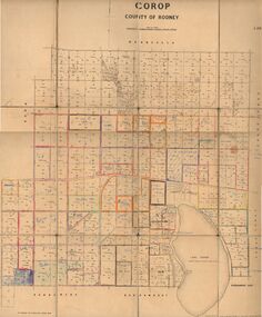
Map - JACK FLYNN COLLECTION: COROP, 8/08/1929
Map: Corop, County of Rodney. Parish plan.By Authority H. J. Green, Govt. Printer, Melb. Dept of Lands and Survey Melbourne by Price 8.8.29map, rodney, parish plan, corop, county of rodney -
 Bendigo Historical Society Inc.
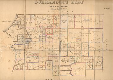
Map - JACK FLYNN COLLECTION: BURRUMBOOT EAST, 21/12/1027
Map: Burrumboot East, County of Rodney. Parish plan.Photo Lithographed at the Department of Lands and Survey, Melbourne by W.J.Butson. 21.12.27map, rodney, parish plan, burrumboot east -
 Bendigo Historical Society Inc.
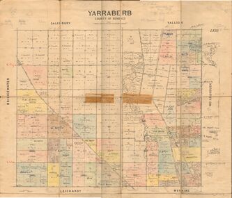
Map - JACK FLYNN COLLECTION: YARRABERB, 2/03/1931
Map: Yarraberb, County of Bendigo. Parish plan.By Authority H.J. Green Govt., Printer. Photo Lithographed at the Department of lands and Survey Melbourne, 2.3.31.map, bendigo, parish plan, yarraberb -
 Bendigo Historical Society Inc.
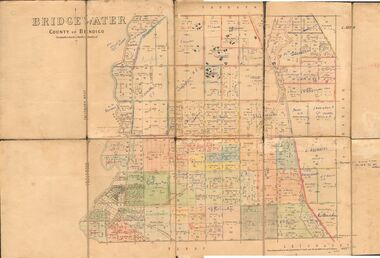
Map - JACK FLYNN COLLECTION: BRIDGEWATER, 6/10/1927
Map: Bridgewater , County of Bendigo. Parish plan.Photo Lithographed at the Department of Lands and Survey, Melbourne by W.J. Butson.map, bendigo, parish plan, bridgewater -
 Bendigo Historical Society Inc.
Map - JACK FLYNN COLLECTION: ECHUCA NORTH, November 1953
Map: Echuca North, County of Rodney. Parish plan.By Authority: W.M. Houston, Government Printer. Drawn and Reproduced at the Dept., of Lands and Survey Melbourne, Victoria. November 1953map, rodney, parish plan, echuca north rodney -
 Bendigo Historical Society Inc.
Map - JACK FLYNN COLLECTION: BURNEWANG, 17/09/1918
Map: Parish of Burnewang, County of Rodney. Parish plan.By Authority, H. J. Green, Acting Government Printer Melbourne. Photo Lithographed at the Department of Lands and Survey, Melbourne by W. J. Butson.map, rodney, parish plan, burnewang, rodney -
 Bendigo Historical Society Inc.
Map - JACK FLYNN COLLECTION: BONN, 16/07/1919
Map: Parish of Bonn, County of Rodney. Parish plan.By Authority A. J. Mullett. Government Printer, Melbourne. Photo Lithographed at the Department of Lands and Survey. Melbourne by W. J. Butson.map, rodney, parish plan, bonn, rodney -
 Bendigo Historical Society Inc.
Map - JACK FLYNN COLLECTION: VILLAGE OF BETLEY, 30/06/1874
Map: Village of Betley, on the Bet Bet Creek, Parish of Dunolly. Parish plan.Photo Lithographed at the Department of Lands and Survey Melbourne by J. Noone 30.6.74map, gladstone, village, betley, bet bet creek, dunolly -
 Bendigo Historical Society Inc.
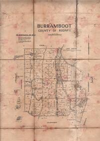
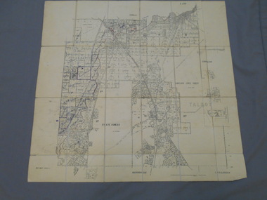
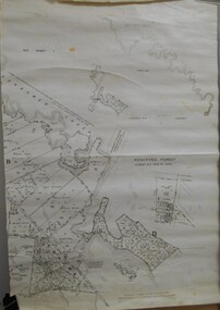
Map - JACK FLYNN COLLECTION: BURRUMBOOT, August 1951
Map: Parish of Burrumboot, County of Rodney. Parish plan.By Authority J.J. Gourley, Government Printer Melbourne. Drawn and Reproduced at the Dept of Lands and Survey, Melbourne, Victoria. August 1951map, rodney, parish plan, burrumboot, rodney -
 Bendigo Historical Society Inc.
Map - JACK FLYNN COLLECTION: BEALIBA, 15/09/1931
Map: Parish of Bealiba, County of Gladstone. Parish plan.By Authority H.J. Green, Government Printer. Photo Lithographed at the Government of Lands and Survey Melbourne. 15.9.31map, gladstone, parish plan, bealiba, gladstone -
 Bendigo Historical Society Inc.
Map - JACK FLYNN COLLECTION: BAMAWM, 19/08/1924
Map: Parish of Bamawm, County of Bendigo. Parish plan.Photo Lithographed at the Department of Lands and Survey, Melbourne by W.J. Butson. 19.8.24map, bendigo, parish plan, bamawm -
 Bendigo Historical Society Inc.
Map - JACK FLYNN COLLECTION: BET BET SHEET 2, 17/09/1931
Map: Parish of Bet Bet Sheet 2. Parish plan.Photo Lithographed at the Lands and Survey Melbourne. 17.9.31map, gladstone, parish plan, bet bet -
 Bendigo Historical Society Inc.
Map - JACK FLYNN COLLECTION: ARCHDALE, 15/01/1936
Map: Parish of Archdale, County of Gladstone. Parish plan. The Allotments have been coloured in with pencil.By Authority H.J. Green, Government Printer Melbourne. Drawn and Reproduced at the Dept, of Lands and Survey, Melbourne, Victoria. 15/01/36map, gladstone, parish plan, archdale , gladstone -
 Bendigo Historical Society Inc.
Map - JACK FLYNN COLLECTION: COHUNA, 1963
Map: Photocopy of parish plan showing Cohuna and a portion of the Gunbower Creek.By Authority. A.C. Brooks Government Printer, Melbourne. Drawn and Reproduced at the Department of Lands and Survey, Melbourne.1963.map, gunbower, parish plan, cohuna , gunbower creek