Showing 621 items matching " tower hill"
-
 Eltham District Historical Society Inc
Photograph, Kangaroo Ground War Memorial Park: Photo display, 10 August 2016
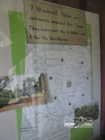
Display in glass cabinet at the base of the stairs at the tower at Kangaroo Ground. 7 windmill palms are growing around the tower. They represent 6 states and 1 for the Territories with map and photo. As part of a program to acknowledge the Anzac Centenary Nillumbik Shire Council partnered with Yarra Plenty Regional Library to provide a bus tour with commentary of local sites of significance. These included Eltham township, the Shire of Eltham War Memorial at Kangaroo Ground, Christmas Hills, Hurstbridge memorial recreation park and finished at Eltham Library to view the Writing the War exhibtion at Eltham Library Community Gallery. Born Digitalworld war 1, war memorials, shire of nillumbik, heritage display, shire of eltham war memorial, kangaroo ground -
 Eltham District Historical Society Inc
Photograph, Liz Pidgeon, Kangaroo Ground War Memorial Park: Photo display, 10 August 2016
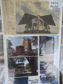
Glass cabinet at the base of the stairs at the tower showing colour photographs depicitng the installation of the CFA tower in November/ December 2009. As part of a program to acknowledge the Anzac Centenary Nillumbik Shire Council partnered with Yarra Plenty Regional Library to provide a bus tour with commentary of local sites of significance. These included Eltham township, the Shire of Eltham War Memorial at Kangaroo Ground, Christmas Hills, Hurstbridge memorial recreation park and finished at Eltham Library to view the Writing the War exhibtion at Eltham Library Community Gallery.Born Digitalworld war 1, war memorials, shire of nillumbik, kangaroo ground, heritage display, shire of eltham war memorial, cfa -
 Eltham District Historical Society Inc
Photograph, Liz Pidgeon, Kangaroo Ground War Memorial Park: Photo display, 10 August 2016
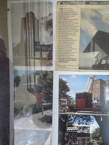
Glass cabinet at the base of the stairs at the tower showing colour photographs depicitng the installation of the CFA tower in November/ December 2009. As part of a program to acknowledge the Anzac Centenary Nillumbik Shire Council partnered with Yarra Plenty Regional Library to provide a bus tour with commentary of local sites of significance. These included Eltham township, the Shire of Eltham War Memorial at Kangaroo Ground, Christmas Hills, Hurstbridge memorial recreation park and finished at Eltham Library to view the Writing the War exhibtion at Eltham Library Community Gallery. Born Digitalworld war 1, war memorials, shire of nillumbik, kangaroo ground, heritage display, shire of eltham war memorial, cfa -
 Eltham District Historical Society Inc
Photograph, Liz Pidgeon, Moor-Rul Viewing Platform, 10 August 2016
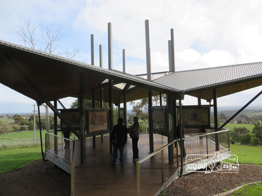
The Moor-Rul Viewing Platform, part of the Kangaroo Ground War Memorial Park opened in April 2007. Eight double-sided interpretation panels on the Moor-rul viewing platform highlight the area's Aboriginal and European history of the area and also details of local geology, flora and fauna. These panels feature high quality graphic design and professionally written text. The subjects covered are: ''Womin Je Ka" Welcome The Kulin Nation Singing, Dancing, Ceremony, Celebration This Country, My Home The Highland Taken Auld Lang Syne "Same Land Different Views" Working the Land Food from the Earth or "Earth's Harvest" Lest We Forget, "And with the going down of the Sun .... (3 panels) This Black Earth Those other indigenous inhabitants - Kangaroo Ground's Wildlife Silent Witnesses - Kangaroo Ground's White Manna Gums Belonging A Place of Reverence and A Tower of Strength Souce: EDHS Newsletter No 173 March 2007. As part of a program to acknowledge the Anzac Centenary Nillumbik Shire Council partnered with Yarra Plenty Regional Library to provide a bus tour with commentary of local sites of significance: Shire of Nillumbik World War One Memorials tour, 10 August 2016. These included Eltham township, the Shire of Eltham War Memorial at Kangaroo Ground, Christmas Hills war memorial, Hurstbridge memorial recreation park and finshed at Eltham Library to view the Writing the War exhibtion at Eltham Library Community Gallery.Born Digitalshire of nillumbik, moor-rul viewing platform, kangaroo ground -
 Eltham District Historical Society Inc
Photograph, Shire of Eltham War Memorial, 10 August 2016
As part of a program to acknowledge the Anzac Centenary Nillumbik Shire Council partnered with Yarra Plenty Regional Library to provide a bus tour with commentary of local sites of significance. These included Eltham township, the Shire of Eltham War Memorial at Kangaroo Ground, Christmas Hills, Hurstbridge memorial recreation park and finished at Eltham Library to view the "Writing the War" exhibition at Eltham Library Community Gallery. Shire of Eltham War memorial at Kangaroo Ground War Memorial ParkBorn Digitalworld war 1, war memorials, shire of nillumbik, kangaroo ground, shire of eltham war memorial, tower, fire spotting cabin, park -
 Eltham District Historical Society Inc
Photograph, Former Caretaker's Cottage, Garden Hill, Kangaroo Ground
... melbourne At Kangaroo Ground Memorial Tower caretaker cottage garden ...At Kangaroo Ground Memorial TowerColour photographcaretaker cottage, garden hill farm, kangaroo ground, kangaroo ground memorial -
 Eltham District Historical Society Inc
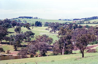
Photograph, Shire of Eltham War Memorial, Memorial Park, Garden Hill, Eltham-Yarra Glen Road, Kangaroo Ground, c.1936, 1936c
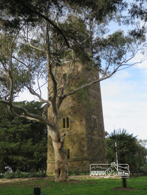
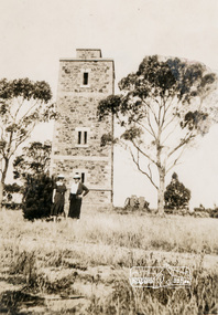
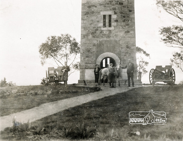
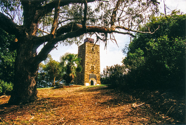
On November 11th 1926 the Shire of Eltham War Memorial Tower at Kangaroo Ground was opened. It is regarded as one of Melbourne’s most outstanding lookout towers. It commands a magnificent 360 degree panorama from Kinglake across the Diamond Valley to Macedon and the You Yangs. It is built on a peak which was once a volcano, 237 metres above sea level. After World War one a memorial cairn was erected on the site, and in 1925 a committee of public-minded citizens began to plan for a tower. Many generous donations of material and money were forthcoming so that in 1926 the Governor General Lord Stonehaven was able to unveil the plaque before a crowd of 500 people There was some concern in the 1960s when the Forests Commission wanted to build a firespotters cabin on the top. At first R.S.L. branches opposed the idea, but it was realised that this use could combine with its use as a tourist attraction, and would ensure its maintenance for the future. Today the Kangaroo Ground tower provides one of the best views around Melbourne and is a fitting memorial to those who died in two world wars. From: Historic items for Diamond Valley Community Radio September 1990 (EDHS collection) On November 8th, 1951, the memorial was re-dedicated by the Governor of Victoria, Sir Dallas Brooks with the addition of the names of men from the Shire of Eltham who fell in the Second World War. Further wreaths were added subsequent to this image in time for the 2001 Reembrance Day service to commemorate the men from th shire who had fallen in the Malayan, Korean, Borneo and Vietnam campaigns. Sepia photograph showing two ladies standing in front of the towergarden hill, kangaroo ground, kangaroo ground memorial, memorial park, shire of eltham war memorial tower, war memorial -
 Eltham District Historical Society Inc
Photograph, Shire of Eltham War Memorial, Memorial Park, Garden Hill, Eltham-Yarra Glen Road, Kangaroo Ground, c.1936
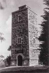
Showing front angle view of tower and old fire watchbox on top On November 11th 1926 the Shire of Eltham War Memorial Tower at Kangaroo Ground was opened. It is regarded as one of Melbourne’s most outstanding lookout towers. It commands a magnificent 360 degree panorama from Kinglake across the Diamond Valley to Macedon and the You Yangs. It is built on a peak which was once a volcano, 237 metres above sea level. After World War one a memorial cairn was erected on the site, and in 1925 a committee of public-minded citizens began to plan for a tower. Many generous donations of material and money were forthcoming so that in 1926 the Governor General Lord Stonehaven was able to unveil the plaque before a crowd of 500 people There was some concern in the 1960s when the Forests Commission wanted to build a firespotters cabin on the top. At first R.S.L. branches opposed the idea, but it was realised that this use could combine with its use as a tourist attraction, and would ensure its maintenance for the future. Today the Kangaroo Ground tower provides one of the best views around Melbourne and is a fitting memorial to those who died in two world wars. From: Historic items for Diamond Valley Community Radio September 1990 (EDHS collection) On November 8th, 1951, the memorial was re-dedicated by the Governor of Victoria, Sir Dallas Brooks with the addition of the names of men from the Shire of Eltham who fell in the Second World War. Further wreaths were added subsequent to this image in time for the 2001 Reembrance Day service to commemorate the men from th shire who had fallen in the Malayan, Korean, Borneo and Vietnam campaigns.Black and white photograph showing front angle view of tower and old watchbox on topgarden hill, kangaroo ground, kangaroo ground memorial, memorial park, shire of eltham war memorial tower, war memorial -
 Eltham District Historical Society Inc
Photograph, Memorial Tower, Kangaroo Ground c.1934, 1934c
Sepia photograph of Joyce McMahon and 'Tiny' Carroll at the War Memorial Tower, Kangaroo Ground c.1934. The guns were installed in 1934 and removed in 1942. Taken in the early 1930s, the photograph ... shows the Kangaroo Ground Tower of Remembance with Joyce McMahon, daughter-in-law of Mr. P. J.McMahon, the then Shire of Eltham Secretary, her horse and a very tall person patting the horse. He is ex-serviceman W. "Tiny" Caroll who was the council's caretaker of the surrounding War Memorial Park. He lived in the stone cottage which still stands in the park. "Tiny" is seen as the fictional character "Tiny Bourke" who, in author Alan Marshall's book "This is the Grass", "was a giant of a man, well over six feet high, with huge hands that completely encircled the cup of tea". The bronze casting, which shows the 79 names of those who paid the "supremen sacrifice" in World War 1 (1914-1918), was erecfed above the entrance to the Tower in September, 1930. The Monterey cypress trees which now form the windbreak around the park's fenceline, were just knee high in this photograph. They were planted in August 1926, with all the plantings paid for, and done, by the public as the Tower was being erected. The two field guns have been identified as of German origin, Krupp 77 mm calibre captured on October 4, 1918 at Geneve, France. They were removed in 1943/44 as a wartime requirement of the Australian Govenment. A public notice dated October 16, 1926 by Cr. H Rutter, Chairman of the Eltham Soldiers War Memorial League stated: "On the summit of that central and conspicuous landmark, Garden Hill, there is being erected a massive memorial tower which will, for all time, remind every passerby of the part played by the men of the Shire of Eltham in the Great War. The work has been undertaken by the people of the Shire a a tribute of love and admiration for those who were known and dear to use in the days of their youth and early manhood, who went out from amongst us, never to return, and whose self-sacrifice has made us, each and all, thier ever-lasting debtors" Harry Gilham, Eltham District Historical Society Kangaroo Ground Tower of Remembrance, A Journey in Time: a column about Nillumbik's history, Nillumbik Mail, 9th August, 2000 Since that research the following has been sourced from Eltham and Whittlesea Shires Advertiser and Diamond Creek Valley Advocate, April 8, 1921, p. 3 Retrieved April 25, 2020, from http://nla.gov.au/nla.news-article57639687 Eltham Shire Council From Town Clerk, Melbourne, stating that a light machine-gun captured by the 22nd battalion, A.I.F. at La Motte Farm, near Beaurvoir, on Oct. 3rd, 1918, during the operations which won the Beauvoir line and completed the smashing of the great Hindenburg defence-system, has been alloted to the Shire of Eltham. - On the motion of Crs Hubbard and Smedley, it was decided to have the gun placed in the Memorial Park. Sepia Photographgarden hill, gun, joyce mcmahon, kangaroo ground, memorial tower, shire of eltham war memorial tower, tiny carroll, war memorials, war trophy, william carroll -
 Ringwood and District Historical Society
Photograph, Ringwood Street at corner of Maroondah Highway Ringwood - 1969
Black and white photograph of Ringwood St. at corner of Maroondah Highway, 1969. Old post office on right and Loughnans Hill in background. (2 images)Written on back of one photograph (MHW 52): "Dec 1969, Ringwood Street. Taken from clock tower. Old P.O. on right corner. New P.O. occupies vacant block in Ringwood Street." Typed under second photograph (MHW 52a): "Ringwood St at cnr of Maroondah Hwy, 1969. Old Post Office on right and Loughnans Hill in background. The vacant block on Ringwood St can be seen where our 4th Post Office now stands. Old telephone exchange and site of new one can be seen at corner of Charter St. Dec 1969." -
 Marysville & District Historical Society
Booklet (Item) - Tourist guide, Ian and Danese Walshe et al, MARYSVILLE and district TOURIST GUIDE, 1982
A tourist guide outlining services, accommodation, activities and places of interest to visit in and around Marysville and the local district.A tourist guide outlining services, accommodation, activities and places of interest to visit in and around Marysville and the local district.marysville, victoria, australia, tourist guide, marysville hotel, castles' store, hawthorne's corner shop, tudor lodge, black spur motel and caravan park, buxton general store, golden fleece roadhouse, marysville garage, burrengeen park, lake mountain, steavenson falls, nanda binya lodge, alpenglow nursery, black spur inn hotel, silver stream trout farm, mccfarlane's grocery, barton's drapery, marysville newsagency, eildon explorer, beauty spot nursery, crossways, pumpernickel, mckenzie's tourist services, blue hills riding school, mountain view horse hire, pitt's garage, maryton park, j l gould sawmill, eildon deer park, eildon weir, maroondah dam, snob's creek, healesville sanctuary, graceburn park, cathedral range, beauty spot walk, tree fern gully walk, michaeldene track, keppel track, woods lookout track, cumberland scenic reserve, cambarville, the big tree, cora-lyn falls, barton's lookout, cumberland falls, sovereign view, wirreanda festival, scenic motel, tower motel, marylands guest house, kooringa guest house, marylyn guest house, mountain lodge, el kanah, marysville hotel motel, buxton hotel motel, black spur inn, buxton caravan park, marysville caravan park, the cumberland, marysville recreation and fun park -
 Eltham District Historical Society Inc
Photograph, War Memorial Tower, Kangaroo Ground
View of Kangaroo Ground Tower from the entrance gate area beside the footpath (Contained in an album originally put together by Harry Gilham. Photos subsequently relocated to photosafe archival storage.) On November 11th 1926 the Shire of Eltham War Memorial Tower at Kangaroo Ground was opened. It is regarded as one of Melbourne’s most outstanding lookout towers. It commands a magnificent 360 degree panorama from Kinglake across the Diamond Valley to Macedon and the You Yangs. It is built on a peak which was once a volcano, 237 metres above sea level. After World War one a memorial cairn was erected on the site, and in 1925 a committee of public-minded citizens began to plan for a tower. Many generous donations of material and money were forthcoming so that in 1926 the Governor General Lord Stonehaven was able to unveil the plaque before a crowd of 500 people. There was some concern in the 1960s when the Forests Commission wanted to build a firespotters cabin on the top. At first R.S.L. branches opposed the idea, but it was realised that this use could combine with its use as a tourist attraction, and would ensure its maintenance for the future, Today the Kangaroo Ground tower provides one of the best views around Melbourne and is a fitting memorial to those who died in two world wars. From: Historic items for Diamond Valley Community Radio September 1990 (EDHS collection) Colour photographgarden hill, kangaroo ground, memorial park, shire of eltham war memorial, shire of eltham war memorial tower, war memorial tower -
 Eltham District Historical Society Inc
Negative - Photograph, Looking northeast from Eltham-Yarra Glen Road towards the Eltham War Memorial Tower, Kangaroo Ground, 1998c
On November 11th 1926 the Shire of Eltham War Memorial Tower at Kangaroo Ground was opened. It is regarded as one of Melbourne’s most outstanding lookout towers. It commands a magnificent 360 degree panorama from Kinglake across the Diamond Valley to Macedon and the You Yangs. It is built on a peak which was once a volcano, 237 metres above sea level. After World War one a memorial cairn was erected on the site, and in 1925 a committee of public-minded citizens began to plan for a tower. Many generous donations of material and money were forthcoming so that in 1926 the Governor General Lord Stonehaven was able to unveil the plaque before a crowd of 500 people There was some concern in the 1960s when the Forests Commission wanted to build a firespotters cabin on the top. At first R.S.L. branches opposed the idea, but it was realised that this use could combine with its use as a tourist attraction, and would ensure its maintenance for the future. Today the Kangaroo Ground tower provides one of the best views around Melbourne and is a fitting memorial to those who died in two world wars. From: Historic items for Diamond Valley Community Radio September 1990 (EDHS collection) On November 8th, 1951, the memorial was re-dedicated by the Governor of Victoria, Sir Dallas Brooks with the addition of the names of men from the Shire of Eltham who fell in the Second World War. Further wreaths were added subsequent to this image in time for the 2001 Reembrance Day service to commemorate the men from th shire who had fallen in the Malayan, Korean, Borneo and Vietnam campaigns.Roll of 35mm colour negative film, 8 strips and associated 10 x 15 cm colour printKodak Gold 100-5eltham-yarra glen road, garden hill, kangaroo ground, memorial park, shire of eltham war memorial tower, war memorial tower -
 Glen Eira Historical Society
Album - Album page, Nithsdale now Five Way Hill, Kambrook Road, Circa 1972
This photograph is part of the Caulfield Historical Album 1972. This album was created in approximately 1972 as part of a project by the Caulfield Historical Society to assist in identifying buildings worthy of preservation. The album is related to a Survey the Caulfield Historical Society developed in collaboration with the National Trust of Australia (Victoria) and Caulfield City Council to identify historic buildings within the City of Caulfield that warranted the protection of a National Trust Classification. Principal photographer thought to be Trevor Hart, member of Caulfield Historical Society. Most photographs were taken between 1966-1972 with a small number of photographs being older and from unknown sources. All photographs are black and white except where stated, with 386 photographs over 198 pages. Glen Eira Heritage Management Plan (1996) by Andrew Ward and Associates - Vol 3 "Nithsdale", built for J.S. Crouchin 1858 and extended in 1885 with a tower and associated rooms, survives as testimony to the nineteenth century occupation of the vicinity of the Kambrook/Glen Eira Road intersection. Caulfield's Building Heritage by Dr Geulah Solomon, Vol 1 p49 records it as a small Victorian mansion home on bluestone foundations of Italianate style with a tower. Built for J S Chambers circa 1860, it was built in stages and then the land subdivided in the 1920s. Other owners include Adolph F Brockhoff (of Brockhoff Biscuits company). Names used besides Nithsdale have been Bundoora and Five Way Hill. Page 102 of Photograph Album with four photographs (three landscape and one portrait) of Nithsdale, now known as Five Way Hill. Three views of the tower and one of the house.Handwritten: "Nithsdale" now "Five Way Hill" Kambrook road [top right] / CNR KAMBROOK AND GLENEIRA ROADS [under bottom right photo] / 102 [bottom right]trevor hart, north caulfield, victorian, mid victorian, late victorian, tower, j.s. crouchin, 1850's, 1880's, italianate, rendered, five way hill, nithsdale, slate roof, plaster arches, ornamental columns, triangular pediment, ornamental parapet, cast iron balconies, kambrook road, glen eira road, t crouch, j s crouchin, mansions, j s chambers, bluestone foundations, land subdivision, adolph f brockhoff, bundoora, house names -
 Glen Eira Historical Society
Album - Album page, Labassa, 4 Manor Grove, Circa 1972
This photograph is part of the Caulfield Historical Album 1972. This album was created in approximately 1972 as part of a project by the Caulfield Historical Society to assist in identifying buildings worthy of preservation. The album is related to a Survey the Caulfield Historical Society developed in collaboration with the National Trust of Australia (Victoria) and Caulfield City Council to identify historic buildings within the City of Caulfield that warranted the protection of a National Trust Classification. Principal photographer thought to be Trevor Hart, member of Caulfield Historical Society. Most photographs were taken between 1966-1972 with a small number of photographs being older and from unknown sources. All photographs are black and white except where stated, with 386 photographs over 198 pages. HISTORY:-- From Victorian Heritage Database citation for Labassa https://vhd.heritagecouncil.vic.gov.au/places/278 as at (26/10/2020) Labassa, Caulfield is one of Melbourne's most lavishly decorated nineteenth century mansions. It resulted from the extensive remodelling in 1890, of an earlier house, known as Sylliott Hill, which was begun in 1862-3 for lawyer, Richard A. Billing. The land at the corner of Balaclava and Orrong Roads was first acquired in 1854 by William Lyall, transferred to his partner, John Mickle, in 1859, who also acquired the adjoining allotment in Balaclava Road, and the three allotments were conveyed to Billing. His first eight-roomed house was extended significantly in 1873 into a twenty-roomed house by architects Crouch and Wilson, who were possibly also responsible for the first house. This reflected Billing's success as a barrister, and he resided at this property until his death in 1882. In 1883 prominent Melbourne businessman, Alexander William Robertson, leased the Sylliott Hill property from Billing's widow, and in 1885 he purchased the adjoining allotment in Balaclava Road. He purchased the Billing's property in 1887 and renamed the 6.31 hectare property, Ontario. In 1889-90, Robertson commissioned the German born architect, John A. B. Koch, to extensively remodel the house into a thirty-five roomed mansion. The existing house was extended and altered, largely resulting in the nineteenth century mansion as it now appears. After Robertson's death in 1896, the house was tenanted until it was eventually sold to the mining millionaire, John Boyd Watson, in 1904. He renamed the property Labassa and carried out repair and re-decoration work to the house. In the early twentieth century, many large estates were subdivided into smaller allotments as the demand for land grew and it became difficult to maintain such large estates. After Watson's death in 1911, portions of the Labassa estate were offered for sale, with Mrs Watson retaining a 1.73 hectare portion containing the house. In 1913 forty-six allotments were auctioned at Labassa Estate, with the formation of Labassa Grove and Ontario Street to the east of the property. Labassa was first recorded as containing flats in 1923 and in the late 1920s, the owner, Robert Hannon, built a red brick block of flats adjacent to the house. Subdivision continued, until the National Trust of Australia (Victoria) purchased the house in 1980 and subsequently purchased adjoining sites, one to the south-east in 1984 (house demolished in 1988) and to the west in 1988. Labassa as it now stands is substantially as it appeared when Koch completed the work in 1890. The original two storey house was transformed into a French Renaissance style mansion, with the addition of a two level L-shaped arcaded verandah and two prominent terminating bays to the south and the east. The building is of unpainted cement render with dressed bluestone plinths, balustraded parapet and steep, slate covered, flat topped mansard roofs behind. A truncated conical roof is a feature of the south bay and a helmeted head is incorporated in the parapet over the east bay. The main south and east facades incorporate many cast cement details, including sculptures, elaborate cornices, swagged Corinthian columns and caryatid consoles flanking the entrance porch, as well as pink marble panels and imitation marble, or scagliola, on curved surfaces. At the rear of the building is a two storey wing and a single storey cottage, the former being connected to the main house by a tower. This section of the house was constructed in 1873. The estate at its peak included stables (1873), conservatory (probably 1890) and a tennis pavilion (probably 1890). All of these outbuildings survive, with the stables and conservatory being converted for residential use after 1922. Internally a range of decorative treatments remain from the late nineteenth century and the early twentieth century, both from the Robertson and Watson periods of occupancy. These include wallpapers, ceiling decoration, chimney pieces, mouldings, joinery and decorative glass. From Victorian Heritage Database citation for H0135 Labassa 2/2A Manor Grove Caulfield North https://vhd.heritagecouncil.vic.gov.au/places/278 as at (26/10/2020) HOW IS IT SIGNIFICANT? Labassa, Caulfield is of architectural, aesthetic and historical significance to the State of Victoria. WHY IS IT SIGNIFICANT? Labassa, Caulfield is of architectural significance as the most prominent example of a small number of houses built in Australia in the French Renaissance style. It is of further note due to the German interpretation of the style and the use of Hellenistic sources, via Germany. It is exceptional for its lavish treatment externally, including marble, scagliola, caryatids, swagged columns, mansard roofs and ornamental cresting. Labassa is of architectural significance as the most important surviving example of German architect, John Koch's domestic work. He undertook a large variety of work in Melbourne, including a number of houses, however Labassa is the most lavish example of his work. Labassa is of aesthetic significance for its outstanding assemblage of late nineteenth and early twentieth century European style interior decoration, which remain remarkably intact. These include a trompe l'oeil ceiling, painted ceilings, embossed imitation leather and other papers, chimney pieces, ceramic tilework, oak parquetry and stained glass, including a tripartite window by Ferguson and Urie, probably dating from the 1873 period. Labassa is of historical significance as an illustrative example of the wealth acquired by a number of prominent Victorian families in the second half of the 19th century. The early development of the property, Sylliott Hill, was due to the wealth acquired by Richard Billing, barrister and fifth Victorian to be appointed Queen's Counsel in 1878. The significant development in 1890 of Ontario, is illustrative of the wealth of Alexander Robertson, a partner in Cobb and Co., a director of Goldsborough Mort & Co., and a pastoral speculator. John B. Watson, whose father had acquired great wealth from the goldfields of Bendigo and subsequently invested in city and country properties, was the third resident to impact on the house, particularly the interiors. The Labassa estate is of historical significance as an illustrative example of the development that occurred in such suburbs as Caulfield in the 1880s due to the land boom, its proximity to Melbourne and the establishment of the Melbourne to Gippsland railway in 1879. It is also illustrative of an estate which succumbed to the pressures of subdividing in the early twentieth century, as properties became difficult to maintain and demand for land close to the city grew. It was typically divided into flats in the 1920s and was used as such for about sixty years. It is of historical significance for its associations with the remnants of the earlier estate which remain extant. These include the stables, conservatory (H2005) and tennis pavilion which all remain on separate sites. Also significant are the remains of early electrical wiring and fittings. Labassa was one of the first houses in Caulfield to be electrified and some of the original wires remain. [Online Data Upgrade Project 2004]Page 128 of Photograph Album with four photographs (two portrait and two landscape) of Labassa.Handwritten: "Labassa" 4 Manor Grove [top right] / Neg 232 8 Oct 1966 [under bottom right photo] / 128 [bottom right]trevor hart, bracketed eaves, slate roof, bay windows, decorative brackets, caulfield north, labassa, richard a. billing, balaclava road, orrong road, sylliott hill, william lyall, crouch and wilson, alexander william robertson, ontario, 1880's, john a. b. koch, mansion, john boyd watson, labassa grove, french renaissance style, l-shaped arcaded verandah, bluestone plinths, balustraded parapet, flat topped mansard roofs, conical roof, elaborate cornices, corinthian columns, caryatid consoles, marble panels, imitation marble, scagliola, tower, conservatory, stables, tennis pavilion, mouldings, decorative glass, caryatids, swagged columns, ornamental cresting, trompe l'oeil ceiling, embossed imitation leather, oak parquetry, stained glass, tripartite window, triple window, ferguson and urie, 1870's, flats, 1920's, electric wiring, 1860's, verandahs, curved windows, arched windows, italianate, terraces, gargoyles, ornamentation, ornate entrance, la bassa, manor grove, st kilda east, victorian, cast iron work, john koch, richard billing, architects, electrification, john mickle, land subdivision, mrs watson, labassa estate, robert hannon, national trust of australia (victoria), sculpture -
 Glen Eira Historical Society
Album - Album page, Labassa, 4 Manor Grove, Circa 1972
This photograph is part of the Caulfield Historical Album 1972. This album was created in approximately 1972 as part of a project by the Caulfield Historical Society to assist in identifying buildings worthy of preservation. The album is related to a Survey the Caulfield Historical Society developed in collaboration with the National Trust of Australia (Victoria) and Caulfield City Council to identify historic buildings within the City of Caulfield that warranted the protection of a National Trust Classification. Principal photographer thought to be Trevor Hart, member of Caulfield Historical Society. Most photographs were taken between 1966-1972 with a small number of photographs being older and from unknown sources. All photographs are black and white except where stated, with 386 photographs over 198 pages. HISTORY:-- From Victorian Heritage Database citation for Labassa https://vhd.heritagecouncil.vic.gov.au/places/278 as at (26/10/2020) Labassa, Caulfield is one of Melbourne's most lavishly decorated nineteenth century mansions. It resulted from the extensive remodelling in 1890, of an earlier house, known as Sylliott Hill, which was begun in 1862-3 for lawyer, Richard A. Billing. The land at the corner of Balaclava and Orrong Roads was first acquired in 1854 by William Lyall, transferred to his partner, John Mickle, in 1859, who also acquired the adjoining allotment in Balaclava Road, and the three allotments were conveyed to Billing. His first eight-roomed house was extended significantly in 1873 into a twenty-roomed house by architects Crouch and Wilson, who were possibly also responsible for the first house. This reflected Billing's success as a barrister, and he resided at this property until his death in 1882. In 1883 prominent Melbourne businessman, Alexander William Robertson, leased the Sylliott Hill property from Billing's widow, and in 1885 he purchased the adjoining allotment in Balaclava Road. He purchased the Billing's property in 1887 and renamed the 6.31 hectare property, Ontario. In 1889-90, Robertson commissioned the German born architect, John A. B. Koch, to extensively remodel the house into a thirty-five roomed mansion. The existing house was extended and altered, largely resulting in the nineteenth century mansion as it now appears. After Robertson's death in 1896, the house was tenanted until it was eventually sold to the mining millionaire, John Boyd Watson, in 1904. He renamed the property Labassa and carried out repair and re-decoration work to the house. In the early twentieth century, many large estates were subdivided into smaller allotments as the demand for land grew and it became difficult to maintain such large estates. After Watson's death in 1911, portions of the Labassa estate were offered for sale, with Mrs Watson retaining a 1.73 hectare portion containing the house. In 1913 forty-six allotments were auctioned at Labassa Estate, with the formation of Labassa Grove and Ontario Street to the east of the property. Labassa was first recorded as containing flats in 1923 and in the late 1920s, the owner, Robert Hannon, built a red brick block of flats adjacent to the house. Subdivision continued, until the National Trust of Australia (Victoria) purchased the house in 1980 and subsequently purchased adjoining sites, one to the south-east in 1984 (house demolished in 1988) and to the west in 1988. Labassa as it now stands is substantially as it appeared when Koch completed the work in 1890. The original two storey house was transformed into a French Renaissance style mansion, with the addition of a two level L-shaped arcaded verandah and two prominent terminating bays to the south and the east. The building is of unpainted cement render with dressed bluestone plinths, balustraded parapet and steep, slate covered, flat topped mansard roofs behind. A truncated conical roof is a feature of the south bay and a helmeted head is incorporated in the parapet over the east bay. The main south and east facades incorporate many cast cement details, including sculptures, elaborate cornices, swagged Corinthian columns and caryatid consoles flanking the entrance porch, as well as pink marble panels and imitation marble, or scagliola, on curved surfaces. At the rear of the building is a two storey wing and a single storey cottage, the former being connected to the main house by a tower. This section of the house was constructed in 1873. The estate at its peak included stables (1873), conservatory (probably 1890) and a tennis pavilion (probably 1890). All of these outbuildings survive, with the stables and conservatory being converted for residential use after 1922. Internally a range of decorative treatments remain from the late nineteenth century and the early twentieth century, both from the Robertson and Watson periods of occupancy. These include wallpapers, ceiling decoration, chimney pieces, mouldings, joinery and decorative glass.From Victorian Heritage Database citation for H0135 Labassa 2/2A Manor Grove Caulfield North https://vhd.heritagecouncil.vic.gov.au/places/278 as at (26/10/2020) HOW IS IT SIGNIFICANT? Labassa, Caulfield is of architectural, aesthetic and historical significance to the State of Victoria. WHY IS IT SIGNIFICANT? Labassa, Caulfield is of architectural significance as the most prominent example of a small number of houses built in Australia in the French Renaissance style. It is of further note due to the German interpretation of the style and the use of Hellenistic sources, via Germany. It is exceptional for its lavish treatment externally, including marble, scagliola, caryatids, swagged columns, mansard roofs and ornamental cresting. Labassa is of architectural significance as the most important surviving example of German architect, John Koch's domestic work. He undertook a large variety of work in Melbourne, including a number of houses, however Labassa is the most lavish example of his work. Labassa is of aesthetic significance for its outstanding assemblage of late nineteenth and early twentieth century European style interior decoration, which remain remarkably intact. These include a trompe l'oeil ceiling, painted ceilings, embossed imitation leather and other papers, chimney pieces, ceramic tilework, oak parquetry and stained glass, including a tripartite window by Ferguson and Urie, probably dating from the 1873 period. Labassa is of historical significance as an illustrative example of the wealth acquired by a number of prominent Victorian families in the second half of the 19th century. The early development of the property, Sylliott Hill, was due to the wealth acquired by Richard Billing, barrister and fifth Victorian to be appointed Queen's Counsel in 1878. The significant development in 1890 of Ontario, is illustrative of the wealth of Alexander Robertson, a partner in Cobb and Co., a director of Goldsborough Mort & Co., and a pastoral speculator. John B. Watson, whose father had acquired great wealth from the goldfields of Bendigo and subsequently invested in city and country properties, was the third resident to impact on the house, particularly the interiors. The Labassa estate is of historical significance as an illustrative example of the development that occurred in such suburbs as Caulfield in the 1880s due to the land boom, its proximity to Melbourne and the establishment of the Melbourne to Gippsland railway in 1879. It is also illustrative of an estate which succumbed to the pressures of subdividing in the early twentieth century, as properties became difficult to maintain and demand for land close to the city grew. It was typically divided into flats in the 1920s and was used as such for about sixty years. It is of historical significance for its associations with the remnants of the earlier estate which remain extant. These include the stables, conservatory (H2005) and tennis pavilion which all remain on separate sites. Also significant are the remains of early electrical wiring and fittings. Labassa was one of the first houses in Caulfield to be electrified and some of the original wires remain. [Online Data Upgrade Project 2004]Page 129 of Photograph Album with three landscape photographs of Labassa. One of the photographs is of Labassa's drive and gates.Handwritten: 4 JUNE 1910 / SALE JUNE 28 1910 "LA BASSA' / "AUSTRALASIAN" FORMERLY "ONTARIO"/ RES OF JOHN B WATSON / 15 ACRES 3 ROADS [under bottom left photo] / 4 JUNE 1910 [under bottom right photo] / 129 [bottom left]trevor hart, bracketed eaves, intricate lacework, slate roof, bay windows, decorative brackets, caulfield north, labassa, richard a. billing, balaclava road, orrong road, sylliott hill, william lyall, crouch and wilson, alexander william robertson, ontario, 1880's, john a. b. koch, mansion, john boyd watson, labassa grove, french renaissance style, l-shaped arcaded verandah, bluestone plinths, balustraded parapet, flat topped mansard roofs, conical roof, elaborate cornices, corinthian columns, caryatid consoles, marble panels, imitation marble, scagliola, tower, conservatory, stables, tennis pavilion, mouldings, decorative glass, caryatids, swagged columns, ornamental cresting, trompe l'oeil ceiling, embossed imitation leather, oak parquetry, stained glass, tripartite window, triple window, ferguson and urie, 1870's, flats, 1920's, electric wiring, 1860's, verandahs, curved windows, arched windows, italianate, terraces, gargoyles, ornamentation, ornate entrance, la bassa, manor grove, st kilda east, gates, cast iron work, richard billing, architects, john koch, electrification, victorian style, drives, john mickle, land subdivision, mrs watson, labassa estate, robert hannon, national trust of australia (victoria), sculpture -
 Federation University Historical Collection
Photograph, William Holstead (thought to be), Ballarat from the Ballarat Town Hall Tower, c1940, 1935 - 1945
The original of this photo is in the Kicinski Family Private Collection. Their ancestor William Holstead was hall keeper at the Ballarat Town Hall, so it is though he took these photographs. Three scanned images of black and white photographs showing Ballarat as viewed from the Ballarat Town Hall. .1- Ballarat towards the Ballarat Post Office and Black Hill 2. Along Sturt Street Ballarat 3. Along Sturt Street and Bridge Street Ballarat looking towards Mt Warrenheip.ballarat, ballarat townscape, sturt street, black hill, tram, warrenheip. bridge street, holstead -
 Federation University Historical Collection
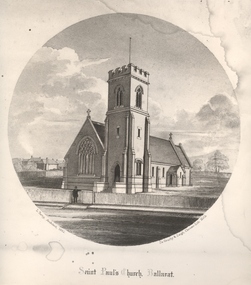
Print - Image, St Paul's Church, Bakery Hill, Ballarat
The architect of St Paul's was L. Terry. Image of St Paul's Church, Ballarat from a lithograph. It shows a church and bell tower behind a picket fence.ballarat, church, st paul's, st pauls, anglican, l. terry, st paul's anglican church -
 Flagstaff Hill Maritime Museum and Village
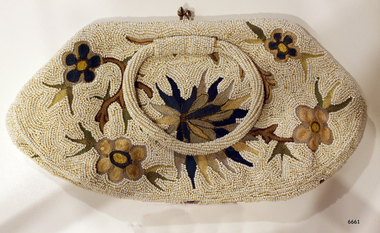
Accessory - Bag, 1930's
In the words of Donor, Betty Stone, "Owned by my aunt Mrs Elsie Mary (nee Dale) Towers, born 24 December 1895, daughter of Ellis and Ann Dale, of Latrigg, Wangoom, Warrnambool. This beaded bag was a personal gift from Miss Lake to Elsie Dale sometime in the early 1930s. Miss Lake was a member of a leading Warrnambool family whose property Lyndoch was situated by the banks of the Hopkins River. After completing her nursing course at Warrnambool Hospital and working there for a time, Elsie Dale was appointed Sister-in-Charge of the newly formed Baby Health Centre, which initially operated in temporary accommodation at or near the Council Chambers. In 1928 the Centre moved into new brick premises on Liebig Street. The building comprised of five rooms, a back yard and a front veranda where mothers parked their prams. The Warrnambool Standard reported in February 1928. The purpose of the Clinic is to the saving of infant's life. Many mothers attended the Clinic in the former location. They were able to acquire valuable knowledge from Sister Dale who is in charge of the Clinic and also have their infants weighed and measured each week. During the early days of the Centre Miss Lake, as a patron, took a keen interest in all aspects of the Centre and co-operated very closely with Sister Dale. Miss Lake would often call in at the centre while her uniformed chauffeur would wait beside her limousine parked in the street outside the Baby Heath Centre. I also recall my aunt driving to Lyndoch to discuss matters concerning the Centre with Miss Lake. Miss Lake purchased this evening bag in England, and upon her return from her overseas tour in the early 1930s, presented it to Sister Dale as a token of appreciation. Dedicated to her vocation, Sister Dale gave unstintingly of her effort, time and resources to create an attractive venue for mothers to visit. Her contribution to the welfare of all mothers and babies in the Warrnambool area, particularly during the Depression years, was considerable. Sister Dale, who drove a Dodge Tourer car, visited mothers in their homes when necessary and regularly visited the indigenous settlement at Framlingham. Amongst my early childhood memories are those of accompanying my aunt when she drove to the Nestles factory at Dennington to purchase large tins of dried milk baby food which she then delivered to the mothers who lived at the Framlingham settlement. Sister Elsie Dale retired in 1949 and moved to Mooroopna after her marriage to Solomon Towers. (Died aged 75 years 27 July 1971) (Note: For additional information please refer to Betty Stone’s book “Pioneers and Places - A History of three Warrnambool Pioneering Families” ie. Chamberlain, Dale and Lees Families)This item is associated with the families of Chamberlain, Dale and Lees. These families are listed in the "Pioneers' Register" for Warrnambool Township and the Shire, 1835-1900, published by A.I.G.S. Warrnambool Branch. Elsie Dale was the first Sister to work in the newly established Baby Health Centre in Warrnambool.Beaded evening bag or clutch purse. The bag was a gift to Elsie Dale from friend Miss Lake, purchased in England early 1930's. The fabric is covered in tiny white beads and features a floral design in browns and greens. The bag has two bead-covered handles and the lining includes a small pocket. Part of the 'Chamberlain Dale Lees Collection'.flagstaff hill, warrnambool, shipwrecked coast, flagstaff hill maritime museum, maritime museum, shipwreck coast, flagstaff hill maritime village, great ocean road, chamberlain, dale, lees, stone, betty stone, warrnambool pioneers, elsie dale, miss lake, lyndoch, handbag, purse, evening bag, beaded handbag, beaded purse, ladies' accessory, clutch purse, warrnambool baby health centre, infant welfare centre -
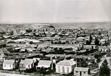 Federation University Historical Collection
Photograph - black and white, Ballarat Looking Towards Black Hill, c1870, c1870
A black and white photograph, and two details, showing Ballarat from the Ballarat Benevolent Asylum. Evident in the photos are houses, gardens, shingle roofs, fences, St Patrick's Cathedral, Black Hill, Ballarat West Fire Brigade tower, mine dumps, mullock heap, large chimneys.ballarat, ballarat townscape -
 Federation University Historical Collection
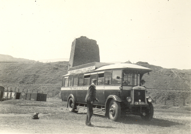
Photograph - Black and White, Frank Wright, St Hilda's Band bus at Llanelly, Wales, 29/5/1934
Frank Wright was a renown resident of Smeaton, where he was born on 2 August 1901. He lived at Laura Villa, and attended Smeaton State School. His father William was a gold miner and his mother's name was Sarah. Their family won many singing and instrumental awards. Frank was tutored by Percy Code and was awarded a gold medal for the highest marks in the ALCM examinations in the British Colonies at the age of seventeen years. He became the Australian Open Cornet Champion by the age of eighteen. A year later, Frank conducted the City of Ballarat Band, and later the Ballarat Soldiers’ Memorial Band. He formed the Frank Wright Frisco Band and Frank Wright and his Coliseum Orchestra. These bands won many South Street awards, and Frank as conductor won many awards in the Australian Band Championship contest. In 1933 Frank Wright sailed to England to conduct the famous St Hilda’s Band and was later appointed Musical Director of the London County Council, where he organized many amazing concerts in parks, in and around the London district. He was made Professor of Brass and Military Band Scoring and conducted at the Guildhall of Music and Drama. Frank was often invited to adjudicate Brass Band Championships around Europe, in Australia, including South Street and in New Zealand. The Frank Wright Medal at the Royal South Street competition is awarded to an individual recognized as making an outstanding contribution to brass music in Australia.Black and white photograph of an early 1930's bus parked on the grass in the foreground, with a man standing on the hidden steps of the bus and another man walking in front. In the middle distance rail lines can be seen on an embankment rising behind a post and wire fence and in the background a tower rises on the closest hill. The bus is the St Hilda's Band bus and the place is Llanelly in Wales.Written in pencil on back - Llanelly, Wales, 29/5/34frank wright, 1930's bus, welsh tower, st hilda's band, sthilda's band bus -
 Federation University Historical Collection
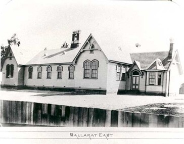
Photograph - Photograph - black and white, Ballarat East State School (No 1071)
The weatherboard Ballarat East State School SS 1071 was formerly known as Specimen Hill. According to 'Visions and Realisations' The Eureka gold lead opened in August 1852, running from Little Bendigo, south beneath Yarrowee Creek into Pennyweight flat, where it was joined 100 yards or so from the intersection of main and Eureka Streets by the Canadian Lead. State School 1071 was formerly known as Ballarat Common School No. 71, and was founded by the Free Presbyterian Church on Specimen Hill in Eureka Street, Ballarat on 01 January 1854. On 20 May 1869 the trustees of the Presbyterian School, Specimen Hill, Ballarat, consented to the transfer of the site to the Board of Education. On 01 September 1870, Specimen Hill, Ballarat, was vested in the Board and then became known as SS 1071. On 01 March 1879 the Minister, The Hon. William Collard Smith, and William Dobbie, Inspector of School Buildings, visited Ballarat to report on the buildings with a view to extensions and renovations. The minister issued instructions for the old wooden part of the school to be demolished, and brick additions to be erected, so that the whole premises would accommodate 350 students. (''Visions and Realisations: A Century of State Education in Victoria, Vol. 2'', Education Department of Victoria, 1973, p 729-730.)Black and white photograph of a weatherboard school with shingle roof known as Ballarat East (SS1071). The building has a brick chimney and bell tower. This school has Castlemaine flagging in the passages.ballarat east state school, education, st paul's school, specimen hill state school -
 Federation University Historical Collection
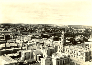
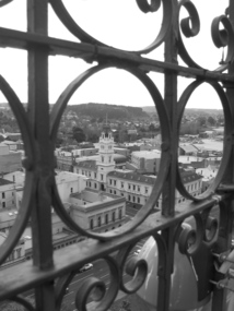
Photograph, Lisa Gervasoni, Ballarat Post Office from Town Hall Tower, 2007
Aerial view of the Ballarat Post Office, corner of Sturt Street and Lydiard Street North, taken from the tower of the Ballarat Town Hall, corner of Sturt Street and Armstrong Street South. The Post Office was opened in December 1858. Photograph taken through the wrought iron of the tower in 2007. The tower and main entrance to the Post Office face Lydiard Street North. Other buildings from the same era are the former Bank of Australia, opposite corner, and the Mining Exchange. In the distance is Black Hill, an old mining area.Black and white photograph of the Ballarat Post Office on the corner of Sturt Street and Lydiard Street North, taken from the tower of the Ballarat Town Hall corner of Sturt Street and Armstrong Street South. View is taken through the wrought iron of the tower. post office, town hall, tower, wrought iron, sturt street, lydiard street, armstrong street, bank of australia, mining exchange, black hill -
 Flagstaff Hill Maritime Museum and Village
Document - Plans, Lighthouse Keeper's Quarters Warrnambool, 1858-1909
The set of seven 1858 plans shows proposed plans for the original Lighthouse Complex that was built on Middle Island in 1858-1859. The whole complex was then transferred to Flagstaff Hill in 1871. The plan, dated 1909, is for proposed additions and repairs to the Quarters at Flagstaff Hill. The plan 'Alterations and Additions' shows alternate plans for changes to the quarters at the Flagstaff Hill location. This plan has no date. The Complex comprised the Lighthouse, the Lighthouse Keepers’ Quarters, the Store (now called the Chart Room) and a Privy, which was not included in these plans. The Keeper’s bluestone Quarters was a cottage divided into two compartments, one for each keeper and his family. The bluestone Store was divided into three; a store, a workshop an oil store (or office). The Privy comprised of a small building also divided into two separate, back-to-back toilets, one for each Keeper and his family. The Flagstaff Hill Keeper's Quarters have had extensions and additions at various times, and these have also been removed at various other times. THE PLANS - *Dec. 1858 (12/58) ‘Lighthouse Keepers Quarters No.2 Warrnambool’ (2375.01)* Public Works Office Melbourne – Front and Back elevations, sections, and floor plan. The drawing shows timber walls. [The floor plan is the closest plan to the current building, however, the walls are timber in this plan.] *Nov. 1858 – No.3 ‘Lighthouse Keepers Quarters Warrnambool’ (2375.02)* Office of Public Works, Melbourne – Back and End elevations and section through. The drawing shows stone walls. One side; Senior Keeper’s bedroom, living room and kitchen with storeroom. Another side; is the Assistant’s bedroom, living room and storeroom. *Nov. 1858 - No.4 ‘Lighthouse Stores Warrnambool’ (2375.03)* Office of Public Works – Front, Side and end elevations, centre section. The drawing shows stone walls. *Nov. 1858 – No.4, ‘Lighthouse Stores No. 2 Warrnambool’ (2375.04)* Office of Public Works – Front, side and end elevations, centre section. The drawing shows timber walls. *Nov. 1858 – ‘Details Lighthouse Keepers Quarters No. 2 Warrnambool’ (2375.05)* Public Works Office Melbourne. The plan shows the foundations, joists and eaves. The drawing shows timber walls. (Nov. 1858 – ‘No.4 ‘Lighthouse No. 2 – Warrnambool’ (2375.06)* Public Works Melbourne (Part of the paper is missing). This plan shows an octagonal tower, internal stairs, a balcony landing, and a weather vane on top. *November 1858 – No. 1, ‘Lighthouse – Warrnambool’ (2375.07)* Office of Public Works Melbourne. This plan shows a round tower, including the stairs, windows on the tower and the weather vane on the top. *4/3/9 [1909] – ‘Additions and Repairs, Lighthouse Quarters, Warrnambool, General Plan’ (2375.8)* Department of Public Works Melbourne’s official stamp is signed by Croft. It shows the floor plans of the Store, Upper Lighthouse and the Quarters. The Store building has three sections; a Store, Work-Shop and Office, with an internal wall between them and separate entries. The Quarters are divided into two dwellings. The Senior Keeper’s side on the left has fireplaces in two of the three bedrooms and there is a pantry and wash house. The Assistant’s side has no fireplaces in the bedrooms and there’s no pantry or washhouse. These plans include proposed changes to the buildings. The Senior Keeper’s Quarters would have a partition on bedroom 2, a bath with plumbing and drainage, a wall moved and a built-in side porch. The Store would also have a built-in porch. The undated plan 'Additions and Alterations' (2375.9) shows alternative arrangements for water tanks, plumbing and such. WARRNAMBOOL'S LADY BAY LIGHTHOUSES- In the 1800s ships sailing from England to Australia began to use Bass Strait as a faster route to Melbourne. Small navigation errors led to many tragic shipwrecks. From 1848 lighthouses were operating along Victoria’s southern coast as a guide for sailors. Coastal towns such as Warrnambool grew and the exchange of trade and passengers were of great benefit. However, the uncertain weather changes, relatively shallow waters and treacherous, hidden rocky reefs were not suitable for a Harbour and in the 1840s and 1850s there were many shipwrecks in the area, with some even stranded in its Lady Bay harbour. A jetty was built in 1850 and a flagstaff to guide seafarers was placed up high on what became known now as Flagstaff Hill. In November 1857 the Victorian Government recommended that Warrnambool Harbour had beacons and two lighthouses to guide vessels into and out of the Harbour safely. The white light of the Middle Island lighthouse was to be used for the first time on September 1, 1859. The red light of the Beach Lighthouse, a wooden obelisk structure, was first operated on March 25, 1860, but in 1868 this light was ‘discontinued’ due to it being too low. Melbourne’s Department of Public Works decided to relocate the Middle Island Lighthouse Complex - Lighthouse, Keeper’s Quarters, Privy, Store Room and even water tanks - to Flagstaff Hill. The lower obelisk was shortened, and a protruding gallery, railing, and external ladder were added, as well as the light from the Beach Lighthouse. A green guiding light was erected on the end of the jetty. The transfer of the Complex began in March 1871. Each shaped stone of the lighthouse was carefully numbered, removed then reassembled on Flagstaff Hill. In 1872 the well was sunk behind the Lighthouse Keeper’s Cottage. The Keepers and families had left Middle Island in April and moved to Flagstaff Hill in October 1871. Vessels entering Lady Bay align the Upper and Lower Lighthouse towers during the day and the lights at night. The Upper Lighthouse is a round tower, the Lower Light is square. The Lighthouses were categorised as harbour lights rather than coastal lights, so they remain under the control of the Victorian Government’s Ports and Harbours section. The lights were originally powered by oil, then acetylene gas, later by electricity, and then converted to solar power in 1988. In 1993 the solar panel was replaced by a battery charger. A decision was made in 1936 to replace the lighthouses’ lights with unattended lights that no longer required Keepers and Assistants. At least 29 Keepers had attended to the lighthouse from its opening in 1859 to when the last official Lightkeepers left In April 1916. The Warrnambool Harbour Board rented out the Quarters from 1916 to 1936. The Board closed down but the rentals continued with other unknown landlords. In the 1970s the Flagstaff Hill Planning Board was set up under the chairmanship of John Lindsay. The Board was to make recommendations to the Warrnambool City Council regarding the use of the buildings and the rest of the Crown Land on the site. The Flagstaff Hill Maritime Village opened in 1975 and began renovating the Cottage in stages, during which time evidence of a 1920s fire was found in the eastern section of the cottage. Additions of a porch on the west and a washroom on the east were made in the 1980s. The western part of the building is now a Shipwreck Museum and the east has returned to a late 19th-century Lighthouse Keeper’s cottage and includes the screen made by Assistant Lighthouse Keeper Thomas Hope during one of his two periods of service there. THE LIGHTHOUSE KEEPERS Lighthouse Keepers were responsible for keeping their Lighthouse’s lights shining at night. They kept a lookout for passing vessels and changes in weather. They were expected to clean, polish and maintain the equipment and buildings. They kept regular and detailed records of who was on watch, and the time the light was lit, trimmed and extinguished. They kept a journal about other events that occurred. They keep regular, accurate Meteorological Logs. It was expected that they were competent in Morse code signalling. They would be called to help in times of disasters and shipwrecks, and to give official statements about these events. Many Lighthouse Keepers also volunteered as members of the lifeboat crew. The Lady Bay lighthouses were officially classified as small, so the Keepers had the official titles of Senior Assistant Lighthouse Keeper and Assistant Lighthouse Keeper. They were employed by the Public Service and paid rent to live in the Lighthouse Quarters. They were compulsorily retired at the age of 60, with most receiving a superannuation payment. Despite their time-consuming duties, there was time to follow hobbies and crafts such as growing vegetables, playing musical instruments, making models of buildings including lighthouses, and crafting furniture pieces. An example of a keeper’s skills is the carved fire screen made by /assistant Keeper Thomas Hope in the early 20th century and displayed in the Lighthouse Keeper’s cottage at Flagstaff Hill. The last occupants of the Middle Island Complex were Senior Keeper Robert Deverell, his Assistant Keeper, Andrew Farncombe, and their families. They all became the first occupants at the Lady Bay Lighthouse Keepers’ Quarters on Merri Street. The Warrnambool Lighthouse Complex plans are the origin of what is now the Lady Bay Lighthouse Complex. They are a record of the people, process and departments involved in bringing the complex into fruition. The plans are significant to the Complex, which is now listed on the Victorian Heritage Register, H1520, for being of historical, scientific (technological) and architectural significance to the State of Victoria. The Complex is significant as an example of early colonial development. The plan are significant for their connection with the important navigational function of the Lighthouses, a function still being performed to this day. The plans are also significant as an example of a product from the Public Works Department in Victoria in the mid-to-late 19th century. The structures built to these plans still stand strong. Plans for the Lighthouse Complex in Warrnambool, including Lighthouses, Keeper's Quarters and Stores. Seven of the plans are on thin fragile paper, one is on thicker, stronger paper. The drawings have been made in pens coloured red and black. They originate from Public Works in Melbourne. Seven were drawn in 1858, one in 1904, the other is not dated.Dec. 1858 - Lighthouse Keepers Quarters No.2 Warrnambool. Public Works Office Melbourne. Nov. 1858 - No.3 ‘Lighthouse Keepers Quarters Warrnambool. Public Works Office Melbourne. Nov. 1858 - No.4 ‘Lighthouse Stores Warrnambool. Office of Public Works. Nov. 1858 - No.4, ‘Lighthouse Stores No. 2 Warrnambool. Office of Public Works. Nov. 1858 - Details Lighthouse Keepers Quarters No. 2 Warrnambool. Public Works Office Melbourne. Nov. 1858 - No.4 ‘Lighthouse No. 2 – Warrnambool. Public Works Melbourne. Nov. 1858 - No. 1, Lighthouse - Warrnambool. Office of Public Works Melbourne. 4/3/9 [1909] - Additions and Repairs, Lighthouse Quarters, Warrnambool, General Plan. Department of Public Works Melbourne. SIGNED "Croft" "15A" on reverse [no date] - Lighthouse Quarters Warrnambool, Additions and Alterations. "9A" on reverseflagstaff hill, warrnambool, lighthouse keeper's cottage, lighthouse residence, lighthouse, plans, public works, melbourne, flagstaff hill maritime museum, maritime museum, shipwreck coast, flagstaff hill maritime village, chart room, quarters, privy, middle island, beach lighthouse, obelisk, lighthouse keeper, assistant keeper, lighthouse complex, lady bay, lady bay complex, keepers, upper lighthouse, lower lighthouse, ports and harbours, cottage, harbour board, flagstaff hill planning board, meteorological record, robert deverell, andrew farncombe, warrnambool port, warrnambool harbour, residence, alterations, repairs, department of works -
 Flagstaff Hill Maritime Museum and Village
Financial record - Record Book, Warrnambool Lighthouse Book, ca. 1870s
Referencing works and removal of fittings and furnishings. Further on the book appears to have been used as a note book on further pages. WARRNAMBOOL'S LADY BAY LIGHTHOUSE COMPLEX; – The original Lady Bay Lighthouse Complex was built on Middle Island in 1858-1859 and comprised the Upper Light, Store (Chartroom), Cottage and Privy. The Lower Light was on a wooden tower on the beach of Lady Bay. In 1871 the Complex was transferred stone-by-stone to Flagstaff Hill, where the flagstaff had been installed since 1853. The Lower Light was erected on top of a bluestone obelisk that was built in 1854 as a navigational marker. The bluestone Lighthouse Keeper’s Quarters was a cottage divided into two compartments, one for the Senior Keeper and his family, the other for the Assistant Keeper and his family. The bluestone Store was divided into three; a store, a workshop, and an oil store (or office). The Privy was a small building divided into two separate, back-to-back toilet rooms, one for the Senior Keeper and his family and one for the Assistant Keeper and family. The record book from the Warrnambool Lighthouse is significant because of its connection with the Lady Bay Lighthouse Complex. The Lady Bay Lighthouse Complex is significant for its important role in the safe navigation of sailing and steam ships into and out of Lady Bay and the Port of Warrnambool. during the colonisation of Victoria and the settlement of southwest Victoria. The lighthouse also helped the passing ships to check the accuracy of their navigation along the southwest coast of Victoria and facilitated the call for help when vessels were in trouble.Warrnambool Lighthouse Book. Green hard covered book with red spine and reinforced corners. Inside are pages with printed horizontal linesBook detailing the cost of removal of the Lighthouse Station from Middle Island to its present location. Also other details. flagstaff hill, warrnambool, shipwrecked-coast, flagstaff-hill, flagstaff-hill-maritime-museum, maritime-museum, shipwreck-coast, flagstaff-hill-maritime-village, warrnambool lighthouse book, record of lighthouse relocation warrnambool, warrnambool historic record book, financial record, middle island -
 Federation University Historical Collection
Book, Art/Sculpture Scrap Book, c1880
This book was number R453 in the Ballarat technical Art School library.Green cloth covered scrapbook with photographic images from antiquity glued onto the pages, and handwritten descriptions.ballarat technical art school library, art, sculpture, arch of titus, temple of jerusalem, roman forum, foro romano, colosseum, palatine hill, rupe tarpeia, piazza de popolo, st peter's, rome, arch of constantine, trevi fountain, fontana di trevi, castello s. angelo, tomb of hadrian, ponte s. angelo, augustus caesar, julius caesar, commodus, dacian captine, posidippo, discobulus, discus thrower, the dying gladiator, demosdthenes, sophocles, pudicizia, fortuna, cerene, calliope, erato, enterpes, flora, sala agrippina, sala de'filosoti, pompei, pompei forno, skull, tre fontane, rome, leaning tower of pisa -
 Federation University Historical Collection
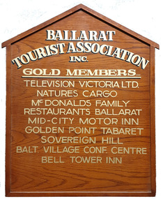
Sign - Honour Board, Ballarat Tourism Association Inc. Gold Members
Timber board listing the following gold members Television Victoria Ltd Natures Cargo McDonalds Family Restaurants Ballarat Mid-City Motor Inn Golden Point Tabaret Sovereign Hill Ballarat Village Conference Centre Bell Tower Inntelevision victoria ltd, natures cargo, mcdonalds family restaurants ballarat, mid-city motor inn, golden point tabaret, sovereign hill, ballarat village conference centre, bell tower inn -
 Murtoa & District Historical Society and Museum
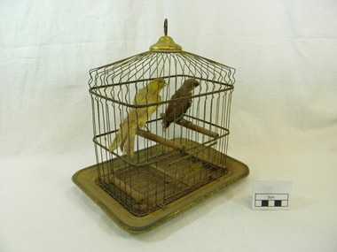
taxidermy bird, 1890
james hill taxidermy collection moved from kewell to murtoa (house) then to tower.held under scientific licenceyellow bird black eyes - held under scientific licence. murtoa lions club (custodians).murtoa, taxidermy, mutant canary, canary, james hill, natural history, flight, natimuk -
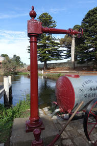 Flagstaff Hill Maritime Museum and Village
Functional object - Water standpipe, Langlands Bros. & Co, 1880-1893
This water standpipe is believed to be the only one of its kind in working order. It was originally located in Warrnambool, on the hillside at the corner of Mickle Crescent and Banyan Street, providing water for the Chinese Market Gardens below, on the flats. It was removed from this location on May 2nd, 1979, with the intention to relocate it at the new Flagstaff Hill Maritime Museum & Village. The standpipe lay in storage for years until the Warrnambool Company, Chemblast, offered to restore it for use as a working display. The display was officially opened on March 31, 2014. The water from the adjacent lake is drawn out with a hand operated water pump, and goes up into the standpipe, where flows through the canvas hose and into the top of the Furphy Farm Water Cart. The display is a visual acknowledgement of the years served by Flagstaff Hill volunteer and Friends of Flagstaff Hill Chairperson, Bob Crossman. Warrnambool’s early settlers had no water supply prior to the mid-1850s. They relied on rain water tanks, domestic wells and springs. The town experienced a huge, destructive fire in William Bateman Jnr. & Co.’s large produce store in November 1856, which highlighted the need for both a fire brigade and a good supply of water. In 1863 a volunteer fire brigade was established. In August 1880 the town celebrated the installation of its first water standpipe on the corner of Liebig and Timor streets. The water was pumped from springs at Cannon Hill through the connected pipeline to the standpipe, then distributed to households via horse and cart. Each of the licenced cart drivers were compelled by Council regulations to keep their carts full from sunset to sunrise, ready to cart water to outbreaks of fire. They received a fee for this service. In 1893 the town installed a water supply, sourced from the Merri River, stored in a reservoir basin and tower in north Liebig Street, and distributed throughout the town in a system of pipes. By late 1939 a reticulated supply was installed, with the water piped in under the Otway Scheme. Standpipes are still used in modern times in rural and remote areas for homes, farms, stock, agriculture and firefighting. Many commercial or government owned standpipes are metered, charging a fee for the quantities of water supplied. This water standpipe was made by Langlands Foundry Co. Limited, Melbourne, which was establish in 1842. It was Melbourne’s first foundry and iron shipbuilder, and one of the largest employers in Victoria at the time. Langlands was known for its high quality workmanship and wide range of goods for mining, engineering, marine, railway and other industrial uses. The company made the first cast bell, the first lamp posts in the colony, and the boiler for the first Australian train. In the 1860s it produced cast iron pipes for the Board of Works, which laid the pipes for Melbourne’s first reticulated water supply. The firm was bought by Austral Otis Co. in 1897.This water standpipe is significant historically as it is believed to be the only one of its type in working condition. The standpipe is significant for being manufactured by early colonial firm Langlands Foundry of Melbourne, which was known for high quality, cast iron products. The firm made the boiler for the first Australian train, assembled the first Australian paddle steamer and made the first Australian cast bell and lamp posts. Langlands was one of the largest employers in Victoria at the time. The standpipe is significant historically as it represents the evolution of water supply services in Australia. Standpipe; vertical cast iron water pipe, painted crimson, fixed in position, tapering inward from the round base to the rectangular joint near the finial on top. A hexagonal pipe extends at right angles from the joint, with an outlet fitting and flow-controlling wheel on the end. A length of canvas hose hangs from the outlet fitting. Inscriptions are on one face of the joint. The standpipe was made by Langlands Foundry Company of Melbourne. Embossed “LANGLANDS FOUNDRY CO. / LIMITED / ENGINEERS / MELBOURNE”warrnambool, flagstaff hill maritime museum, maritime museum, shipwreck coast, flagstaff hill maritime village, great ocean road, flagstaff hill, standpipe, stand-pipe, water standpipe, fire standpipe, firefighting equipment, water supply equipment, chinese market gardens, banyan street, liebig street, water tower, bateman’s fire, working display, water supply, town water, rural water, reticulated water, cannon hill spring, merri river, otway water, water carters, horse and cart water supply, volunteer fire brigade, langlands foundry, early melbourne, iron works, bob crossman, late 19th century water supply -
 Bendigo Historical Society Inc.
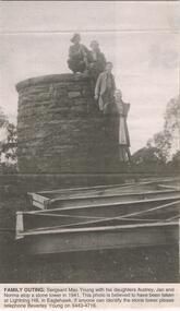
Newspaper - JENNY FOLEY COLLECTION: FAMILY OUTING
Bendigo Advertiser '' The way we were'' from 2002. Family outing: Sergeant Mac Young with his daughters Audrey, Jac and Norma atop a stone tower in 1941. This photo is believed to have been taken at Lighting Hill, in Eaglehawk. The clip is in a folder.newspaper, bendigo advertiser, the way we were