Showing 2588 items matching "aerial"
-
 Moorabbin Air Museum
Document (Item) - Specification for Aerial Spraying Equipment For Iroquois Aircraft, Technical Requirement Specification: AC158 Aerial Spraying Equipment For Iroquois Aircraft
-
Moorabbin Air Museum
Document (Item) - Ansett Map of Operations in Northern Queensland, Cairns Aerial Service
Contains two copies of an undated map of Ansett routes in Northern Queensland. -
Moorabbin Air Museum
Book - THE NORTH-WEST AERIAL FRONTIER 1919-1934, EDWARD P. WIXTED, 1985
-
Moorabbin Air Museum
Photograph (Item) - Photograph album pre WW 2 small prints aerial shots of Melbourne and assorted aircraft
-
Moorabbin Air Museum
Book - Aerial Flight: Aerodynamics, F. W. Lanchester, Aerodynamics: Constituting the First Volume of a Complete Work on Aerial Flight, 1907
Blue hard covernon-fiction -
Moorabbin Air Museum
Book - Aerial Flight: Aerodynamics, F. W. Lanchester, Aerodonetics: Constituting the Second Volume of a Complete Work on Aerial Flight, 1910
Blue hard covernon-fiction -
Moorabbin Air Museum
Booklet (Item) - Australian Aerial Services Ltd. Time Table And General Information
-
Moorabbin Air Museum
Document (item) - Royal Australian Navy - Air Publication AP(RAN) 28 Issue 4 - Delmar Aerial Target Towing Facility
-
Moorabbin Air Museum
manual (item) - Aerial Targeting Systems, Scale Model Mirach 100/5 Aerial Target
-
Moorabbin Air Museum
Manual (Item) - UK Ministry of Technology Aerial Targets and Drones Reports, United Kingdom The Technical Co-Operation Program Report on 12th Meeting of Working Panel H-1 Aerial Targets and Drones September 1969 Vol I and 2
Ministry of Technology UK -
Moorabbin Air Museum
Manual (item) - CAC Advanced Technology Aerial Refuelling System, Advanced Technology Aerial Refuelling System ( ARS) Slide Presentation
CAC Collection -
 Queenscliffe Maritime Museum
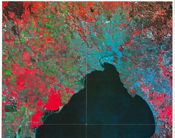
Print - Melbourne by Satellite by Woman's Weekly c1986, Aerial photo of Port Phillip c1986, c1986
Port PhillipAerial view of Port Phillip from 705km, 1986.Colour print insert from Woman's Weekly 1986, 'Melbourne by Satellite'.Reverse " Nil " -
 Ballarat Tramway Museum
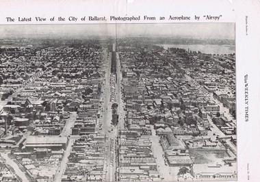
Photograph - Illustration/s, Herald & Weekly Times Ltd, Sturt St. Aerial View, 1934, Jan. 1934
Yields information about Ballarat from the eastern aspect of the city looking west in an aerial view dated 1934. Shows buildings such as the Gas Works and other buildings that no longer exist.Photographic reproduction of Ballarat looking west down Sturt St., page 6 of Magazine section of Weekly Times, Jan 20, 1934. On rear is two colour photo of Alexandria Avenue, Melbourne. Record updated and image added 21/9/2013.trams, tramways, ballarat, sturt st., aerial views -
Moorabbin Air Museum
Book - The Empire Express, Charles L. Scrivner, The Empire Express: The story of the U.S. Navy PV squadron' aerial strikes against the Japanese Kuriles during WWII
The book covers the Aeronautical action that occurred between the Japanese and Americans in the northern pacific islands during the second world war. It focuses on the aircraft and action that occurred between the Kuril Islands and Aleutian IslandsThe front cover is a stylised image of a sea plane over a body of coastal water. The image was created by Paul Matt.non-fictionThe book covers the Aeronautical action that occurred between the Japanese and Americans in the northern pacific islands during the second world war. It focuses on the aircraft and action that occurred between the Kuril Islands and Aleutian Islandsww2, pacific theatre, imperial japanese army air service, united states air force, second world war -
 Kew Historical Society Inc
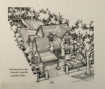
Drawing - Property Illustration, Margaret Picken, 33 Molesworth Street, Kew (aerial), 1993
After training as a Cartographic Draftsman within the mining industry, I worked as a property illustrator for real estate firms in the eastern suburbs of Melbourne for 23 years from 1983. I initially photographed houses with a Polaroid camera and made a 'thumbnail' sketch while there. The photos were used to scale off a sketch in pencil and then that sketch was overlaid with drafting film and the 'pen and ink' completed. The pens I used were the Rotring ‘Rapidigraph’ drafting pens. The ink was also made by Rotring (German).The film was ‘Rapidraw’, polyester drafting film, double matte. It takes a very fine line and doesn’t bleed. As well as house sketches, there were often floor plans and site plans ordered. Aerial sketches were ordered when the property needed an overall view. (Margaret Picken, 2020)This drawing is one of a series created by Margaret Picken for a number of real estate agents in Melbourne between 1983 and 2005. Each work is signed and dated by the artist.Gift of Margaret Picken, 2020Pen and ink architectural drawing on drafting film of 33 Molesworth Street, Kew by Margaret Picken.33 MOLESWORTH ST., KEW / MARGARET PICKEN ~93 / WOODARDS ~ KEWartist -- margaret picken 1950-, 33 molesworth street, 33 molesworth street - kew (vic) -
Stawell Historical Society Inc
Photograph, Stawell Aerial View showing many of Stawell distinctive buildings 1998 -- Coloured
stawell -
University of Melbourne, Burnley Campus Archives
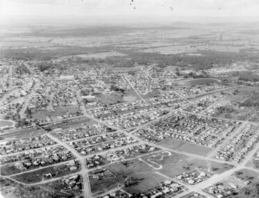
Photograph - Black and white print, Aerial View of Burnley Campus, 1977
Framed enlargements. (A) Burnley College and surrounding suburbs showing the nearly constructed Freeway, the College in the bend of the Yarra River, Glenferrie Road to the East Swan Street to the North. (B) Enlargement of (A) showing detail of Burnley College.burnley college, suburbs, freeway, yarra river, glenferrie road, east swan street, aerial view -
 University of Melbourne, Burnley Campus Archives
Photograph - Black and white print, Airspy, Aerial View of Burnley Campus c. 1930, c. 1930
Taken before the Boulevard was built, and probably before the flood of 1934. Therefore probably 1929-1934. Information provided by TH Kneen and EB LittlejohnColour photograph of black and white photograph. Photograph of Burnley Campus and large area of surrounding suburbs of Hawthorn and Toorak. It shows the Carter Oval, later modified, the Plant Research Institute (built 1929) and the Box Thorn Hedge (Lycium ferrocissimum).burnley campus, suburbs, hawthorn, toorak, carter oval, plant research institute, boxthorn hedge, lycium ferrocissimum -
 Federation University Art Collection
Painting - Artwork - Painting, Elizabeth Signorella, Aerial Scape by Elizabeth Signorella
This item is part of the Federation University Art Collection. The Art Collection features over 1000 works and was listed as a 'Ballarat Treasure' in 2007.art, artwork, tafe business collection -
 Stawell Historical Society Inc
Photograph, Aerial Photograph of town of Stawell Sept 1983
Photo taken facing North East and Mine site at rear of photo6 Stawell, Victoria Sept 1983panorama, streetscape -
Moorabbin Air Museum
Tool (item) - Aerial Dead Reckoning Computer RAAF Mk.1
-
 National Vietnam Veterans Museum (NVVM)
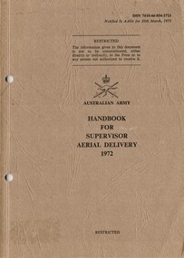
Booklet, Australian Army, Australian Army: Booklet For Supervisor Aerial Delivery, 1972
A brown coloured cardboard cover with black information on the front. Top right reads DSN 7610-66-054-1713. Under the Australian Army Insigia are the details of the booklet. Down the left hand side there are two punch holes.australia - armed forces - service manuals, supervisor, training -
Merbein District Historical Society
Photograph, Aerial view Merbein blocks & Murray River flood (framed), unknown
merbein township, murray river -
 Federation University Historical Collection
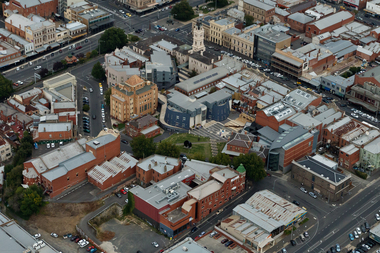
Photograph, Aerial View of Camp Street, Ballarat
camp street, arts academy, deakin place, alfred deakin place, art gallery of ballarat, ballarat state officers, former ballarat library, ballarat trades hall, george hotel, regent theatre, former ballarat courthouse -
Stawell Historical Society Inc
Photograph, Aerial Photo of Stawell 1981, 1981
Shows Railway Institute fire 1981. Swimming Pool in Cato Lake. Sawmill, King StreetVery Large Colour Print -
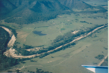 University of Melbourne, Burnley Campus Archives
Photograph - Colour print, Aerial View of Countryside, Unknown
4 colour photographs taken from a small aeroplane. Views of countryside, river, valley, mountains, dams, farm buildings countryside, aerial views, river, valley, farm buildings, dams, mountains -
Moorabbin Air Museum
Journal (item) - Avro Anson Dragonfly DH- 90 John Harrison Pander Mitsubishi MC 20 Wackett Consolidated LB-30, Man and Aerial Machines
-
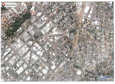 Bendigo Historical Society Inc.
Map - BENDIGO MAP AERIAL VIEW
Map of Bendigo. Aerial View of Bendigo. Published by City of Bendigo. Undated.photograph, aerial, bendigo -
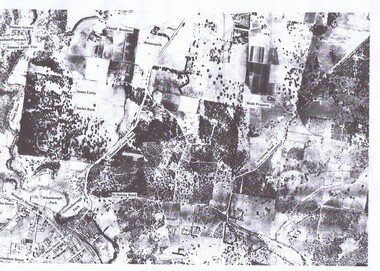 Greensborough Historical Society
Aerial Photograph, St Helena 1945, 1945_
Aerial survey photograph of St. Helena Road area of Greensborough3 copies, various enlargements of aerial surveygreensborough, st helena, st helena road -
Glenelg Shire Council Cultural Collection
Souvenir - Souvenir Badge - Portland Harbour, n.d
Shield shaped badge showing an aerial view of harbourbadge, souvenir, portland harbour, aerial