Showing 1535 items matching "aerial photograph"
-
 Creswick Campus Historical Collection - University of Melbourne
Still Image, 1966
... Aerial Photographs... envelope. Aerial Photographs Still Image ...Subject: Creswick . 9 brown envelopes marked Run 6. containing c 80 marked up photos. Numbers 30 to 50, 88 - 91 in sequence. Stored in a brown cardboard file box . Photos marked on rear as on loan from the Photographic Library of theForests Commission Victoria . pencilled in date "1946?" on one envelope.Aerial Photographs -
Creswick Campus Historical Collection - University of Melbourne
Still Image, 1952
... Aerial Photographs... section of a topographical map marked State Aerial Survey. Stored ...Subject: King Lake . 6 brown envelopes marked Run 3, 4, 7, 7a, 8, 9 containing c. 80 prints. 1 section of a topographical map marked State Aerial Survey. Stored in a brown cardboard file box marked King Lake Run No.3 - 9. (x9). Photos commissioned by Forests Commission Victoria.Aerial Photographs -
Creswick Campus Historical Collection - University of Melbourne
Still Image, 1962
... Aerial Photographs... 1962. Aerial Photographs Still Image ...Subject: Ballarat-Creswick Plantations Block A . 4 brown envelopes marked Run 4 No. 135 - 138 of c.30 prints total. Marked up with red pen. Stored in a brown cardboard file box marked Errinundra Project..Combien Project...Ballarat Plantation. commissioned by Forests Commission Victoria 1962.Aerial Photographs -
Creswick Campus Historical Collection - University of Melbourne
Still Image, 1958 -1967
... Aerial Photographs... file box marked as per contents. Aerial Photographs Still Image ...Subject: Calder Ridge Project . 3 brown envelopes marked Run 2 c.26 prints total. 1967. Subject: Mt Cole Mt Lonach 1958. 1 brown envelopes marked Run 4. c.15 prints total. Subject: Colac 1966 . 1 brown envelopes marked Run 6 c.8 prints total. Subject: Mt Tamoritha, Mt Arbuckle. 1966. 1 brown envelopes marked Civil AS-FRI-FCV-APMF CO-OP project no. 13.23 - 13.38 c.18 prints total. Stored in a brown cardboard file box marked as per contents.Aerial Photographs -
Creswick Campus Historical Collection - University of Melbourne
Still Image, 1956
... Aerial Photographs... A. Run 3. Aerial Photographs Still Image ...Subject: Ballarat-Creswick Plantations Block A . 9 brown envelopes marked Run 3 No. 84 - 92 of c.76 prints total. 1 brown envelopes marked Run 4 No. 127-136 of 9 prints total. 1956. Marked up with red pen. Stored in a brown cardboard file box marked Ballarat-Cres.Plantation Block A. Run 3.Aerial Photographs -
Creswick Campus Historical Collection - University of Melbourne
Still Image, 1964 - 1966
... Aerial Photographs.....Combien Project...Ballarat Plantation. Aerial Photographs Still ...Subject: Combienbar River Project. 1964. 2 brown envelopes marked Run 16, 17 of c.18 prints total. Subject: Errinundra Project. 1966. 2 brown envelopes marked Run 12, 13 of c.14 prints total. Stored in an unmarked brown cardboard file box . Related to item 1507. Marked Errinundra Project..Combien Project...Ballarat Plantation.Aerial Photographs -
Creswick Campus Historical Collection - University of Melbourne
Still Image, 1956
... Aerial Photographs... marked Creswick Run.6. Aerial Photographs Still Image ...Subject: Ballarat-Creswick Plantations Block A . 1956. 9 brown envelopes marked Run 4 No. 127 - 139 of c.75 prints total. Stored in a brown cardboard file box marked Creswick Run.6.Aerial Photographs -
Creswick Campus Historical Collection - University of Melbourne
Still Image, 1968
... Aerial Photographs.... Aerial Photographs Still Image ...Subject: Creswick 1968 Project . 1 x annotated map in envelope marked Run 3 No's 30 - 38 with runs marked up from aerial phtographs flown 1956 - 1968 on drafted plan of Creswick Plantations. 1 x topographical map marked Creswick with annotation "Mapsheet key diagram". 1 x topographical map marked Ballarat annotated with a grid of numbers. 13 brown envelopes marked Run 1 -3 No. 21 - 38 (missing sequences) of c.44 prints total. Mix of black and white and colour. Range of dates. Stored in a brown cardboard file box marked Creswick 1968 Project.Aerial Photographs -
Creswick Campus Historical Collection - University of Melbourne
Still Image, 1956 -1968
... Aerial Photographs... cardboard file box marked Creswick 1968 Project. Aerial Photographs ...Subject: Creswick 1956 . 8 brown envelopes marked Run 4 -3 No. 31 - 42 of c.45 prints total. 2 empty brown envelopes marked run 4 no.38 -39, and run 6 no. 85-87. 5 loose black and white prints. Subject: Lower Glenelg Plantation . 2 brown envelopes marked Run 1. No. 26-27. Stored in a brown cardboard file box marked Creswick 1968 Project.Aerial Photographs -
Creswick Campus Historical Collection - University of Melbourne
Still Image, 1948 - 1956
... Aerial Photographs... "INTERPRETATIONS. South Gippsland .......Otway area prints" Aerial ...Subject: Coffs Harbour 1956 . Subject: Grampians no. 11-15. Subject: Kinglake area 1948 -1950 Run 7 no.14 - 16, Run 8 no.69 -70 . Subject: Princetown Run 7 . Subject: South Gippsland Run 7 no.102 - 105. Subject: Otway area. Stored in 5 brown envelopes in a brown cardboard file box marked "INTERPRETATIONS. South Gippsland .......Otway area prints"Aerial Photographs -
Creswick Campus Historical Collection - University of Melbourne
Still Image, 1956 -1968
... Aerial Photographs... Creswick 1968 Project Run 1 24 - 27. 2. 42 - 47. 3. 32-33 Aerial ...Subject: Creswick 1968 Project . 10 brown envelopes marked Run 1 -3. Run 6. No.s missing sequences. c.50? prints total. Mix of black and white and colour. Range of dates. Stored in a brown cardboard file box marked Creswick 1968 Project Run 1 24 - 27. 2. 42 - 47. 3. 32-33Aerial Photographs -
Creswick Campus Historical Collection - University of Melbourne
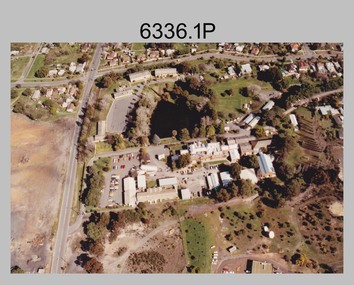
Still Image, 1990
... Aerial Photographs... Building 719 Creswick goldfields Subject Creswick. Colour. Aerial ...Subject Creswick. Colour.Aerial Photographs -
 Bendigo Military Museum
Booklet - RAEME BOOKLET, Ian Beaton, 4th Base Workshop Battalion
... . Aerial photograph of Bandiana workshops.... a black background. 2. Colour aerial photograph of a group.... Aerial photograph of Bandiana workshops. Cooper Collection ...1. Booklet outlines the work carried out by 4th Workshop Battalion, Bandiana, Victoria. Part of the Cooper Collection. 2. Aerial photograph of Bandiana workshops.1. A4 sized booklet with twelve pages secured to cover with two staples. Front cover has RAEME insignia in gold and silver on a black background. Title in gold and silver lettering. Pages contain colour photographs and text in white. Pages have a black background. 2. Colour aerial photograph of a group of buildings at Bandiana. 3. Business card featuring RAEME insignia and text in blue print.cooper collection, bandiana, 4th workshop battalion, raeme -
 City of Kingston
Photograph - Black and white, 20 December 1945
... This aerial photograph depicts the changing landscape...Aerial photograph taken in 1945 of Cheltenham and Highett... Parkdale This aerial photograph depicts the changing landscape ...This aerial photograph depicts the changing landscape of Cheltenham and Highett since WWII. Photographed in 1945, there is a mix of urban dwellings and industrial development and precedes the major transformation of Cheltenham with the development of the Southland shopping centre in the 1960s and expansion in the 1990s.A large part of Cheltenham was originally established as a rural market gardening community. The railway line and station brought urban development to the area and in the north, the Highett area was dominated by the Highett Gas Works. Cheltenham became a major destination for shopping in the 1960s with the opening of Southland.Aerial photograph taken in 1945 of Cheltenham and Highett within the City of Kingston. The image includes the Highett Reserve, (top right), the Methodist Children Homes (now Southland), Nepean Highway and Jamieson Street. Highett Gas Works is visible in the top left and the land now named William Fry Reserve at the intersection of Bay Road and Nepean Highway. A visible large parcel of land on the corner of Bay Road and Nepean Highway was developed in the 1990s as the west side addition to Southland. The densely vegetated area in the upper right sector of the image is now dense with housing. Tulip Grove, Heather Grove and Gilford Street are visible bottom left. This image is possibly from the collection of aerial photographs commissioned by the Department of Crown Lands and Survey and taken by Adastra Airways.Black ink: 57252 White lettering: VIC-10 57252 20.12.45 [lens information indecipherable] PROJ. No.5 MELB. METROP AREA Black pencil: 80highett, cheltenham, highett gas works, urbanisation -
 City of Kingston
Photograph - Black and white, 20 December 1945
... This aerial photograph depicts the changing landscape...Aerial photograph taken in 1945 of Cheltenham and Highett... Parkdale This aerial photograph depicts the changing landscape ...This aerial photograph depicts the changing landscape of Cheltenham and Highett since WWII. Photographed in 1945, there is a mix of urban dwellings and industrial development and precedes the major transformation of Cheltenham with the development of the Southland shopping centre in the 1960s and expansion in the 1990s.A large part of Cheltenham was originally established as a rural market gardening community. The railway line and station brought urban development to the area and in the north, the Highett area was dominated by the Highett Gas Works. Cheltenham became a major destination for shopping in the 1960s with the opening of Southland.Aerial photograph taken in 1945 of Cheltenham and Highett within the City of Kingston. The image includes the Highett Reserve, (top right), the Methodist Children Homes (now Southland), Nepean Highway and Jamieson Street. Highett Gas Works is visible in the top left and the land now named William Fry Reserve at the intersection of Bay Road and Nepean Highway. A visible large parcel of land on the corner of Bay Road and Nepean Highway was developed in the 1990s as the west side addition to Southland. The densely vegetated area in the upper right sector of the image is now dense with housing. Tulip Grove, Heather Grove and Gilford Street are visible bottom left. This image is possibly from the collection of aerial photographs commissioned by the Department of Crown Lands and Survey and taken by Adastra Airways.Black type: Reverse lettering VIC-10 57252 20.12.45 [lens information indecipherable] PROJ. No.5 MELB. METROP AREA White lettering: Reverse writing 57252cheltenham, highett, highett gas works, urbanisation -
Glenelg Shire Council Cultural Collection
Photograph - Photograph - Aerial view from N.W. Port of Portland, 05/03/1971
... Photograph - Aerial view from N.W. Port of Portland...b x w photograph - unframed. Aerial view from N.W. Port... Development. Fishermens' facilities. Photograph Photograph - Aerial ...Port of Portland Authority archives.Front: (no inscriptions) Back: (no inscriptions)port of portland archives, portland harbour -
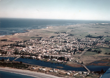 Port Fairy Historical Society Museum and Archives
Photograph
... Coloured aerial photograph ... pedestrian bridge Coloured aerial photograph Photograph Photograph ...Aerial-Port Fairy 1972Coloured aerial photograph aerial, moyne river, douglas house, railway, water tower, traffic bridge, pedestrian bridge -
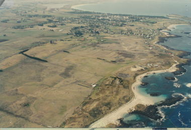 Port Fairy Historical Society Museum and Archives
Photograph
... Coloured aerial photograph... sand hill cemetery water tower west Coloured aerial photograph ...Aerial view of Port Fairy WestColoured aerial photographsand hill cemetery, water tower, west -
 Melbourne Tram Museum
Drawing, Melbourne & Metropolitan Tramways Board (MMTB), Aerial photographs Bundoora Tram Extensions, Plenty Road – MMTB Drawings – 12/1979, Bundoora Extension – Metropolitan Transit Authority – 2/1983, John-Connell – Mott Hay and Anderson – Preliminary drawings for the Latrobe Modal Interchange – August 1984, 1979 to 1984
... Interchange - 1984. Large print – Aerial photographs Bundoora Tram...On rear of aerial photograph sheet - at right hand end... Construction MTA On rear of aerial photograph sheet - at right hand end ...Set of drawings for the MMTB Plenty Road extension in 1979, MTA extension to Bundoora in 1983 and the Latrobe Uni Modal Interchange - 1984. Large print – Aerial photographs Bundoora Tram Extensions Stage 2 – Albert St to Kingsbury Drive Stage 3 – Kingsbury Drive to Settlement Road Has been rolled, left hand edge damaged, right hand edge torn Compiled by the ROW Division – 2/1981. Has written on rear at right hand end “Bundoora Tram Extension – Official MMTB Plans” 760H x 1190W Plenty Road – MMTB Drawings – 12/1979 P15123 Tyler St to Walsal Avenue P15124 Walsal Ave t McColl St P15125 McColl St to Dorrington Avenue Bundoora Extension – Metropolitan Transit Authority – 2/1983 P15400 Dorrington Avenue to Barwon Avenue P15401 Barwon Avenue to Nicholson Ave P15402 Nicholson St to Barling Park P15403 Barling Park to Darebin Creek P15404 Darebin Creek to Scott Grove P15405 Scott Grove to Clunes Street P15406 Clunes St to Cash St P15408 Cash St to Bundoora Park P15409 Bundoora Park to Larundel Hospital P15410 At Larundel Hospital P15411 Larundel Hospital to Marne Court P15412 Marne Court to Cherrywood Court P15413 Cherrywood Court to Morwell Ave P15414 Morwell Ave to Grimshaw St P15415 Grimshaw St to Nickson Street P15416 Nickson St to McLeans Road John-Connell – Mott Hay and Anderson – Preliminary drawings for the Latrobe Modal Interchange – August 1984. 8094-A-20 Set Out Plan and Paving Details 8094-A-21 Elevations 8094-A-22 Sections 8094-A-23 Roof Plan and Stormwater Layout 8094-A-24 Canopy Details 8094-A-25 Toilet Block and Waiting Room 8094-A-28 Miscellaneous DetailsOn rear of aerial photograph sheet - at right hand end “Bundoora Tram Extension – Official MMTB Plans” in felt pen.trams, tramways, plenty rd, bundoora, latrobe university, mmtb, construction, mta -
 Bendigo Military Museum
Photograph - Army Survey Regiment aerial photos, Fortuna, Bendigo, c1990
... This is a set of two aerial photographs of the Army Survey...This is a set of two aerial photographs of the Army Survey... goldfields This is a set of two aerial photographs of the Army Survey ...This is a set of two aerial photographs of the Army Survey Regiment, Fortuna, Bendigo taken in c1990. These photos are indicative of a series of 23 aerial photos in the collection taken from multiple angles and elevations. It is possible the photographs were taken from a hot air balloon. The approximate date of the photos is based on the existence of the new printing building - Wazgoose Hall and the new records building.This is a set of two aerial photographs of the Army Survey Regiment, Fortuna, Bendigo taken circa 1990. Colour photographs are on photographic paper and scanned at 300 dpi. They are part of the Army Survey Regiment’s Collection. .1) to .2) - Photo, colour, c1990. Army Survey Regiment aerial photos.royal australian survey corps, rasvy, army survey regiment, army svy regt, fortuna, asr -
 Ringwood and District Historical Society
Photograph, Aerial view of Ringwood -1972
... Black and white aerial photograph... photograph Aerial view of Ringwood -1972 Photograph ...Black and white aerial photographSimilar photograph -Reg 926 located in NWD 02-09-07 - Item no G0033 -
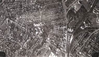
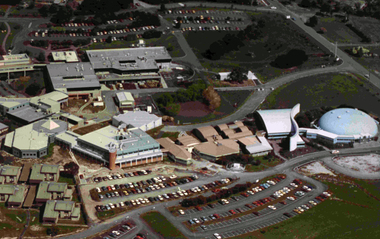 Federation University Historical Collection
Photograph, Gippsland Campus
... Aerial photograph of Gippsland Campus... education gippsland campus collection Aerial photograph of Gippsland ...Aerial photograph of Gippsland Campuschurchill campus, gippsland campus, gippsland institute of advanced education, gippsland campus collection -
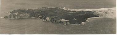 Phillip Island and District Historical Society Inc.
Photograph, Bryant West
... Aerial Photograph of Cape Woolamai.... woolamai phillip island john jenner bryant west Aerial Photograph ...One of a collection of over 400 photographs in an album commenced in 1960 and presented to the Philip Island & Westernport Historical Society by the Shire of Phillip IslandAerial Photograph of Cape Woolamai.local history, photography, photographs, coastline, cape woolamai, phillip island, john jenner, bryant west -
 Greensborough Historical Society
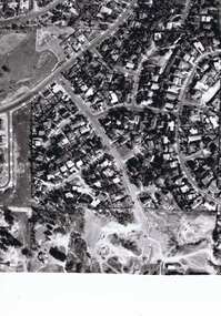
Photograph - Digital image, Frank Solomon, Pig Farm, Weidlich Road area: aerial view, 02/08/2009
... Digital copy of aerial photograph... greensborough Digital copy of aerial photograph Pig Farm, Weidlich Road ...An aerial view of the pig farm in Weidlich Road Greensborough, owned by Werner Hanusch. The land was used as a pig farm and quarry from 1954 and has now been subdivided into the Evelyn Way estate. This project of fifty, one double storey, dwellings was commenced on 2/8/2009 and completed on 6/2/2011.An example of the changing land use in Greensborough, from farming to residential.Digital copy of aerial photographwerner otto fritz hanusch, pig farm st helena, weidlich road greensborough, one evelyn way greensborough -
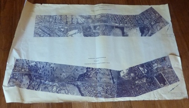
 St Kilda Historical Society
Photograph - Photo map, 28/01/1951
... Black and white aerial photograph... Black and white aerial photograph Photograph Photo map ...One of a series of photo-maps produced for the Department of Crown Lands and Survey (1857-1983). For correlation with a current map, and access to other historical photo maps of Victoria, see the Historic Photo-Maps Index published by the Department of Environment, Land, Water and Planning at https://services.land.vic.gov.au/DELWPmaps/historical-photomaps/Black and white aerial photograph1424-45 SECRET 534 Run 18 Lens 12" Melbourne Metropolitan 12150 28.1.51 M639albert park, st kilda junction, st kilda pier, catani gardens, st kilda, prahran, albert park lake, 1951, middle park, st kilda beach, windsor -
 St Kilda Historical Society
Photograph - Photo map, 17/01/1951
... Black and white aerial photograph... Metropolitan 12150 17.1.51 M586 Black and white aerial photograph ...One of a series of photo-maps produced for the Department of Crown Lands and Survey (1857-1983). For correlation with a current map, and access to other historical photo maps of Victoria, see the Historic Photo-Maps Index published by the Department of Environment, Land, Water and Planning at https://services.land.vic.gov.au/DELWPmaps/historical-photomaps/Black and white aerial photograph1414-21 538 Run 19 Lens 12" Melbourne Metropolitan 12150 17.1.51 M586st kilda, st kilda botanical gardens, peanut farm, elwood, 1951, point ormond, elwood canal, st kilda beach -
 St Kilda Historical Society
Photograph - Photo map, 28/01/1951
... Black and white aerial photograph... and white aerial photograph Photograph Photo map ...One of a series of photo-maps produced for the Department of Crown Lands and Survey (1857-1983). For correlation with a current map, and access to other historical photo maps of Victoria, see the Historic Photo-Maps Index published by the Department of Environment, Land, Water and Planning at https://services.land.vic.gov.au/DELWPmaps/historical-photomaps/Black and white aerial photograph1424-118 534 Run 20 Lens 12" Melbourne Metropolitan 12150 18.1.51M639elwood, point ormond, elwood park, elsternwick park, elwood beach, 1951 -
 St Kilda Historical Society
Photograph - Photo map, 17/01/1951
... Black and white aerial photograph..." Melbourne Metropolitan 12150 17.1.51 M586 Black and white aerial ...One of a series of photo-maps produced for the Department of Crown Lands and Survey (1857-1983). For correlation with a current map, and access to other historical photo maps of Victoria, see the Historic Photo-Maps Index published by the Department of Environment, Land, Water and Planning at https://services.land.vic.gov.au/DELWPmaps/historical-photomaps/Black and white aerial photograph1414-20 538 Run 19 Lens 12" Melbourne Metropolitan 12150 17.1.51 M586elwood, elsternwick, st kilda east, balaclava, ripponlea, 1951 -
 St Kilda Historical Society
Photograph - Photo map, 28/01/1951
... Black and white aerial photograph..." Melbourne Metropolitan 12150 28.1.51 M639 Black and white aerial ...One of a series of photo-maps produced for the Department of Crown Lands and Survey (1857-1983). For correlation with a current map, and access to other historical photo maps of Victoria, see the Historic Photo-Maps Index published by the Department of Environment, Land, Water and Planning at https://services.land.vic.gov.au/DELWPmaps/historical-photomaps/Black and white aerial photograph1424-44 534 Run 18 Lens 12" Melbourne Metropolitan 12150 28.1.51 M639 -
 St Kilda Historical Society
Photograph - Photo map, 28/01/1951
... Black and white aerial photograph... aerial photograph Photograph Photo map ...One of a series of photo-maps produced for the Department of Crown Lands and Survey (1857-1983). For correlation with a current map, and access to other historical photo maps of Victoria, see the Historic Photo-Maps Index published by the Department of Environment, Land, Water and Planning at https://services.land.vic.gov.au/DELWPmaps/historical-photomaps/Black and white aerial photograph1424-43 534 Run 18 Lens 12" Melbourne Metropolitan 12150 28.1.51 M639armadale, malvern, st kilda cemetery, caulfield north, st kilda east, 1951