Showing 1538 items matching "armstrong"
-
 Whitehorse Historical Society Inc.
Document, Sale of Estate Agency, 1926
Copy of receipt for preliminary deposit of ten pounds from Mr N. Armstrong to Fred C. Drake on purchase of Estate agency business, good will and car for the sum of four hundred poundsCopy of receipt for preliminary deposit of ten pounds from Mr N. Armstrong to Fred C. Drake on purchase of Estate agency business, good will and car for the sum of four hundred pounds and copy of lodgement of remaining sums at Bank Of Victoria Ltd.Copy of receipt for preliminary deposit of ten pounds from Mr N. Armstrong to Fred C. Drake on purchase of Estate agency business, good will and car for the sum of four hundred pounds armstrong, norman, real estate agents, drake, fred c, whitehorse road, mitcham -
 Melbourne Legacy
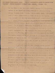
Document - Speech, Savige Memorial Oration, 1954
A typed copy of a speech by Legatee Brian Armstrong delivered as the Savige Memorial Oration at the Federal Conference of Legacy Clubs in Canberra on 22 October 1954. It is an account of Savige's life, his war service and his role in Legacy. Legatee Armstrong was a good friend of Savige. The moving address described General Savige's life and service career, and how he formed Legacy in 1923 at the suggestion of his former Commander, Major General Sir John Gellibrand. He said at the time of his death the late General had been a member of Legacy for 30 years, and had been chosen to represent Legacy at the Coronation of Queen Elizabeth. Following the Second World War he held many important posts, one of the most notable being Co-ordinator of Demobilisation. Legatee Armstrong told the conference that if a memorial to the founder of Legacy was required, they only had to look around themselves. This is a photocopy on flimsy brown paper, two other copies are in the archive.A record of the life and service of Legatee Stan Savige.Brown quarto paper with black type x 11 pages of a speech about Legatee Savige.Typed on top of first page 'Sir Stanley George Savige KBE. Copy of Commemorative address by Legatee Brian Armstrong - Federal Conference of Legacy Clubs, Canberra, October 1954.'vale, stan savige, conference -
 Whitehorse Historical Society Inc.
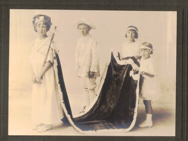
Photograph - Black and white photograph, Queen Carnival 1924, 1942
Studio portrait of Dorothy Armstrong as the winning Queen of the 1924 Queen Carnival, in aid of the Vermont Sports Reserve. Her attendants are Stuart Corr, Lily Stevens and Lucy Brockell. The photograph is mounted on card.vermont reserve, armstrong, dorothy jean, queen carnival 1924, corr, stuart, brockell, lucy, stevens, lily -
Whitehorse Historical Society Inc.
Document, Certificate, 1946
A certificate issued by the City of Nunawading with the coat of arms and seal in colour.A certificate issued by the City of Nunawading with the coat of arms and seal in colour. Proclaimed 26 May 1946. Presented to 'L.A. Jones in grateful recognition and high appreciation for services rendered for King and Empire in the Great War 1939- 1945'. Signed by the mayor N. Armstrong and the Town Clerk, K. Charlesworth.A certificate issued by the City of Nunawading with the coat of arms and seal in colour. city of nunawading, world war, 1939-1945, certificates, jones, lionel arthur -
 Warrnambool and District Historical Society Inc.
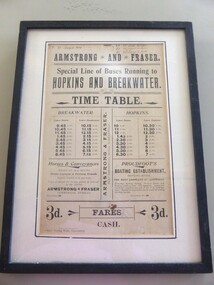
Poster - Armstrong and Fraser timetable, Late 19th Century
This poster is a time table for the coaches operated by Armstrong and Fraser.Their stables were in Liebig Street, Warrnambool next to the Commercial Hotel (The Whalers Hotel today) Armstrong and Fraser commenced business in 1882 and were prominent in Warrnambool at the end of the 19th century and the beginning of the 20th century. The kept as many as 70 horses in their stables and operated a daily timetable for tourists especially those going to the mouth of the Hopkins River and to the breakwater. This poster is of considerable interest as the time table indicates the extensive business of an early coach service in Warrnambool over 100 years ago. The poster comes possibly from the old Warrnambool Museum.This is a sheet of paper containing black printing and handwriting in black ink. It is encased in a black wooden frame with a white cardboard surround and a black border. It has glass protection. There is string and wire at the back for hanging the item . ARMSTRONG* AND * FRASER Special line of buses Running to HOPKINS AND BREAKWATER TIME TABLE (Also other detail re fares, Proudfoot's boating establishment and horses and conveyances) ( Handwriting 87,90, 91 January to March July to Sept. April to June Jany to March) warrnambool, bus timetable, armstrong and fraser -
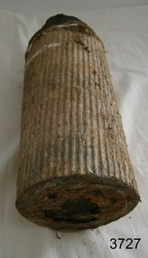
 Flagstaff Hill Maritime Museum and Village
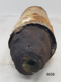
Weapon - Ammunition Shell, Late 19th-early 20th century
Ammunition shell was used in a 40 lb Armstrong Rifled Breach Loading (RBL) Gun. It does not contain explosives because the projectile and explosive were separate items. The Armstrong 40 lb BL Gun There were 4 x 40lb Armstrong (RBL) Guns issued to the Ham and Beef Battery at Hastings Victoria. After the Hastings Battery field artillery disbanded, the 4 Guns were transferred from the Hastings Battery to the Warrnambool Battery field artillery in 1904. (There is a photograph of one of these guns on its carriage, pictured in front of the Orderly room (Drill Hall) at Warrnambool, which is now the Library of South West TAFE). The 40lb Armstrong Guns were recalled back to Melbourne when the government issued the updated 4.7inch QF (Quick Firing) Naval Guns, mounted on carriages, to the Warrnambool Garrison Artillery 1907. The Hastings Museum today holds one of the original 40lb Armstrong RBL guns that were at first at Hastings and then Warrnambool, evidenced by tracing the numbers on that gun. This gun has now been restored. Surviving 40 lb Armstrong BL Guns in Australia The Hastings Museum has restored one of the Guns that was at Hastings and then from 1904-1907 in Warrnambool. This Gun is now on display at the Hastings Museum.This ammunition shell from a 40lb Armstrong RBL gun is very significant because of its association with the Warrnambool Battery Field Artillery in the early 1904-1907. It is known that the original 40lb Armstrong RBL gun used in Warrnambool is now restored and on display at the Hastings Museum.Ammunition shell from a 40Ib Armstrong Rifled Breach loading (RBL) Gun. Metal bullet-shaped object, flat base, tapering to cone-shaped tip. Parallel equidistant ridges run from outer edge of base to position where cone shape begins. Tip has a square-shaped hole in the centre and has a very uneven surface. Base has corrosion and metal is flaking away. Does not contain explosives. Remnants of white paint-like substance in several places. From the Hastings, Victoria, area. Late 19th - early 20th century.flagstaff hill maritime museum and village, great ocean road, shipwreck coast, ammunition shell, 40 lb, war equipment, hasting battery field, defence of warrnambool -
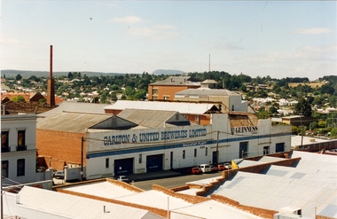 Federation University Historical Collection
Photograph - Photograph - Colour, Former Ballarat Brewery
Colour photograph of a former brewery in Armstrong Street Southballarat brewery, carlton and united breweries -
 Flagstaff Hill Maritime Museum and Village
Weapon - Ammunition Shell, late 19th-early 20th century
Ammunition shell was used in a 40 lb Armstrong Rifled Breach Loading (RBL) Gun. The shell was fired into Westernport Bay by the Hastings Battery Field Artillery in late 1800’s or early 1900’s. It was recovered by divers in recent times. It does not contain explosives because the projectile and explosive were separate items. The Armstrong 40 lb BL Gun There were 4 x 40lb Armstrong (RBL) Guns issued to the Ham and Beef Battery at Hastings Victoria. After the Hastings Battery field artillery disbanded, the 4 Guns were transferred from the Hastings Battery to the Warrnambool Battery field artillery in 1904. (There is a photograph of one of these guns on its carriage, pictured in front of the Orderly room (Drill Hall) at Warrnambool, which is now the Library of South West TAFE). The 40lb Armstrong Guns were recalled back to Melbourne when the government issued the updated 4.7inch QF (Quick Firing) Naval Guns, mounted on carriages, to the Warrnambool Garrison Artillery 1907. The Hastings Museum today holds one of the original 40lb Armstrong RBL guns that were at first at Hastings and then Warrnambool, evidenced by tracing the numbers on that gun. This gun has now been restored. Surviving 40 lb Armstrong BL Guns in Australia The Hastings Museum has restored one of the Guns that was at Hastings and then from 1904-1907 in Warrnambool. This Gun is now on display at the Hastings Museum. This ammunition shell from a 40lb Armstrong RBL gun is very significant because of its association with the Warrnambool Battery Field Artillery in the early 1904-1907. It is known that the original 40lb Armstrong RBL gun used in Warrnambool is now restored and on display at the Hastings Museum. Ammunition shell from a 40Ib Armstrong Rifled Breach loading (RBL) Gun. Metal bullet-shaped object, flat base, tapering to cone-shaped tip. Parallel equidistant ridges run from outer edge of base to position where cone shape begins. Tip has a square-shaped hole in the centre and has a very uneven surface. Base has corrosion and metal is flaking away. Does not contain explosives. Remnants of white paint-like substance in several places. From the Hastings, Victoria, area. Late 19th - early 20th century.flagstaff hill, warrnambool, shipwrecked coast, flagstaff hill maritime museum, maritime museum, shipwreck coast, flagstaff hill maritime village, great ocean road, ammunition shell, 40 lb armstrong rbl gun, volunteer corps, war equipment, defence forces, warrnambool bettery field artillery, hastings battery field artillery, defence of warrnambool -
Whitehorse Historical Society Inc.
Article, The first council - City's records are corrected
Undated article in which Norman Armstrong corrects earlier information and states that the first meeting of the Shire Council of Blackburn and Mitcham was at Blackburn on 16 Oct 1925.Undated article in which Norman Armstrong corrects earlier information and states that the first meeting of the Shire Council of Blackburn and Mitcham was at Blackburn on 16 Oct 1925.Undated article in which Norman Armstrong corrects earlier information and states that the first meeting of the Shire Council of Blackburn and Mitcham was at Blackburn on 16 Oct 1925.shire of blackburn and mitcham, ellemer, h, mock, w, elmore, algernon john, watts (cr), husband, charles edward, gray, l.j., bishop, herbert thomas, bayley, leonard.sherwin, armstrong, norman, fankhauser, g.f. -
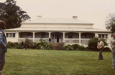 Linton and District Historical Society Inc
Photograph, St Enoch's Homestead, Stockyard Hill, 1986, 1986
Colour photograph showing closer view of old homestead with people in grounds. Photograph taken on LDHS trip to St Enoch's and Mt Widderin, 1986."St Enoch's Bill Armstrong".ldhs activities, st enoch's homestead -
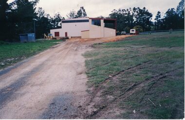 Linton and District Historical Society Inc
Photograph, Linton Recreation Reserve hall under construction, 1995
Colour photograph of the building under construction at the Linton Recreation Reserve, 1995"Letty Armstrong - July 1995"linton recreation reserve -
 Stawell Historical Society Inc
Memorabilia - Realia, c1880's
Mens Metal Belt Clips with Cricket Scene from Armstrong's Area stawell -
Moorabbin Air Museum
Document (Item) - Spitfire Trainer Conversions , MK VIII - Specification No. 499 , Mk IX - Specification No.502
Vickers - Armstrong Limited Supermarine Works -
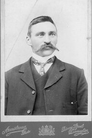 Stawell Historical Society Inc
Photograph, Portrait of gentleman in suite with large handlebar mustache
Collected by Dorothy Brumby in relation to Great Western ResearchB/W Portrait of gentleman with large handlebar mustache Armstrong Photo Princes Street Dunedin -
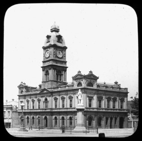 City of Ballarat Libraries
Glass Slide, Ballarat Town Hall
Town Hall completed 1872. Thomas Moore statue erected 1889. No evidence of electric trams indicates the photograph is pre-1905.Previously unknown image of Ballarat. The set and its subjects indicate these images were produced to promote Ballarat and were perhaps aimed at tourists.Ballarat Town Hall, se corner Sturt and Armstrong Streets, image not dated. gas lamps, statue -
 Stawell Historical Society Inc
Memorabilia - Realia, c1880's
Women's Metal Belt Clip with Raised Flower Pattern from Armstrong's Area stawell -
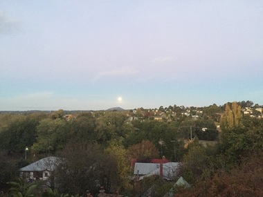 Ballarat Heritage Services
Photograph - Photograph - Colour, Clare Gervasoni, Towards Mt Warrenheip, Ballarat, 29/04/2018
Colour photographooking towards Mt Warrenheip from Armstrong Street South, Ballarat.mount warrenheip, ballarat -
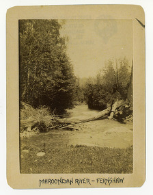 Marysville & District Historical Society
Photograph (Item) - Black and white photograph, Maroondah River - Fernshaw, c1900
An early black and white photograph of the Watts River at Fernshaw. The photograph has been incorrectly labeled as the Maroondah River - Fernshaw.An early black and white photograph of the Watts River at Fernshaw. The photograph has been incorrectly labeled as the Maroondah River - Fernshaw.ARMSTRONG COLLECTION 42 STATION STREET/ SANDRINGHAM 3191/ TEL. (03) 9521 5442/ IAN M.L. ARMSTRONG OAMwatts river, fernshaw, maroondah river, victoria -
 Marysville & District Historical Society
Photograph (Item) - Black and white photograph, Fernshaw, c1900
An early black and white photograph taken at Fernshaw.An early black and white photograph taken at Fernshaw. Fernshaw was a rural township 63 km north-east of Melbourne and 10 km north-east of Healesville. Situated on the Watts River, near where a log had fallen making a convenient crossing, Fernshaw was settled in the 1860s. It provided good country for orchards and berry growing. The location was at the foot of Blacks Spur, with Mounts Juliet and Mondah rising on either side, providing spectacular scenery. There were nearby fern gullies giving rise to the name – ‘shaw’ is old English for thicket or wood. By 1875 Fernshaw had a post office (1865), two hotels, a school (1871) and stores. It was famed for its beauty, attracting tourists. In 1886 the Melbourne and Metropolitan Board of Works began work on the Watts River water catchment scheme – later to become Maroondah – and the Board obtained approval for the catchment country to be reserved and kept free of settlement. This required the removal of the Fernshaw township, which was completed by about 1890. The area was described in the 1903 Australian handbook:ARMSTRONG COLLECTION 42 STATION STREET/ SANDRINGHAM 3191/ TEL. (03) 9521 5442/ IAN M.L. ARMSTRONG OAMfernshaw, healesville, watts river, orchard, berry orchard, blacks spur, black spur, mount juliet, mount mondah, maroondah dam, victoria -
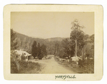 Marysville & District Historical Society
Photograph (Item) - Black and white photograph, Marysville, c1900
An early black and white photograph of the main road in Marysville in Victoria showing the Keppels Australian Hotel.An early black and white photograph of the main road in Marysville in Victoria showing the Keppels Australian Hotel which was built and opened by the Keppel Family in 1865. The Keppels Australian Hotel was the first hotel to be opened in Marysville. The Keppel Family were among Marysville's earliest pioneering families.ARMSTRONG COLLECTION 42 STATION STREET/ SANDRINGHAM 3191/ TEL. (03) 9521 5442/ IAN M.L. ARMSTRONG OAMaustralian hotel, marysville, keppel family, maurice john keppel, keppels australian hotel, keppels hotel, victoria -
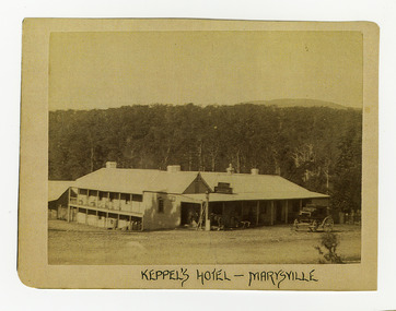 Marysville & District Historical Society
Photograph (Item) - Black and white photograph, Keppel's Hotel - Marysville, c1900
An early black and white photograph of the Keppels Australian Hotel in Marysville in Victoria.An early black and white photograph of the Keppels Australian Hotel which was built and opened by the Keppel Family in 1865. The Keppels Australian Hotel was the first hotel to be opened in Marysville. The Keppel Family were among Marysville's earliest pioneering families.ARMSTRONG COLLECTION 42 STATION STREET/ SANDRINGHAM 3191/ TEL. (03) 9521 5442/ IAN M.L. ARMSTRONG OAMkeppel hotel, keppels australian hotel, australian hotel, keppel family, maurice john keppel, marysville, victoria -
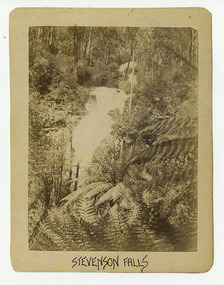 Marysville & District Historical Society
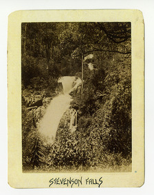
Photograph (Item) - Black and white photograph, Stevenson Falls, c1900
An early black and white photograph of Steavenson Falls in Marysville in Victoria.An early black and white photograph of Steavenson Falls in Marysville in Victoria. The Steavenson Falls is named after the Victorian Assistant Commissioner of Roads and Bridges, John Steavenson who arrived in Victoria in the early 1860s.ARMSTRONG COLLECTION 42 STATION STREET/ SANDRINGHAM 3191/ TEL. (03) 9521 5442/ IAN M.L. ARMSTRONG OAMstevenson falls, steavenson falls, marysville, victoria, john steavenson -
 Marysville & District Historical Society
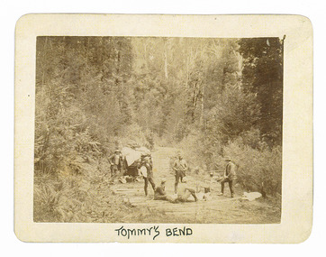
Photograph (Item) - Black and white photograph, Tommy's Bend, c1900
An early black and white photograph taken at Tommy's Bend near Marysville in Victoria.An early black and white photograph taken at Tommy's Bend near Marysville in Victoria. Tommy's Bend is a stretch of road 10 kilometres from Marysville on the Woods Point Road up to Lake Mountain. This road was originally constructed as a corduroy road (or log road) is a type of road or timber trackway made by placing logs, perpendicular to the direction of the road over a low or swampy area. The result is an improvement over impassable mud or dirt roads, yet rough in the best of conditions and a hazard to horses due to shifting loose logs.ARMSTRONG COLLECTION 42 STATION STREET/ SANDRINGHAM 3191/ TEL. (03) 9521 5442/ IAN M.L. ARMSTRONG OAMtommy's bend, marysville, victoria, marysville-wood's point road, corduroy road -
 Marysville & District Historical Society
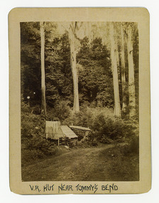
Photograph (Item) - Black and white photograph, V.R. Hut near Tommy's Bend, c1900
An early black and white photograph of a Victoria Roads worker's hut near Tommy's Bend near Marysville in Victoria. An early black and white photograph of a Victoria Roads worker's hut near Tommy's Bend near Marysville in Victoria. Tommy's Bend is a stretch of road 10 kilometres from Marysville on the Woods Point Road up to Lake Mountain.ARMSTRONG COLLECTION 42 STATION STREET/ SANDRINGHAM 3191/ TEL. (03) 9521 5442/ IAN M.L. ARMSTRONG OAMtommy's bend, marysville, victoria, marysville-wood's point road -
 Marysville & District Historical Society
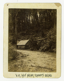
Photograph (Item) - Black and white photograph, V.R. Hut near Tommy's Bend, c1900
An early black and white photograph of a Victoria Roads worker's hut near Tommy's Bend near Marysville in Victoria. An early black and white photograph of a Victoria Roads worker's hut near Tommy's Bend near Marysville in Victoria. Tommy's Bend is a stretch of road 10 kilometres from Marysville on the Woods Point Road up to Lake Mountain.ARMSTRONG COLLECTION 42 STATION STREET/ SANDRINGHAM 3191/ TEL. (03) 9521 5442/ IAN M.L. ARMSTRONG OAMtommy's bend, marysville, victoria, marysville-wood's point road -
 Marysville & District Historical Society
Photograph (Item) - Black and white photograph, Beech Forest Beyond Tommy's Bend, c1900
An early black and white photograph of The Beeches, which is known as the Beech Grove, near Tommy's Bend near Marysville in Victoria.An early black and white photograph of The Beeches, which is known as the Beech Grove, near Tommy's Bend near Marysville in Victoria. Tommy's Bend is a stretch of road 10 kilometres from Marysville on the Wood's Point Road up to Lake Mountain. The Beeches Rainforest Walk is a loop that starts at Taggerty Cascades before winding through Myrtle Beech and Mountain Ash woodland and is one of the many walking tracks in and around Marysville. It is accessible from Lady Talbot Drive which is a 24 kilometer scenic rainforest car journey which passes a number of walks and waterfalls in the Yarra Ranges National Park. Lady Talbot Drive is named after Lady Sarah Elizabeth, the wife of Sir Reginald Talbot, who was the Governor of Victoria from 25th April, 1904 to 6th July 1908.ARMSTRONG COLLECTION 42 STATION STREET/ SANDRINGHAM 3191/ TEL. (03) 9521 5442/ IAN M.L. ARMSTRONG OAMtommy's bend, marysville, victoria, marysville-wood's point road, beech grove, wood's point road, lake mountain, beeches rainforest walk, taggerty cascades, myrtle beech, mountain ash, lady talbot drive, lady talbot forest drive, lady sarah elizabeth talbot, sir reginald talbot -
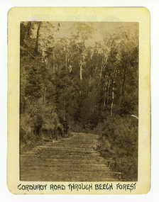 Marysville & District Historical Society
Photograph (Item) - Black and white photograph, Corduroy Road Through Beech Forest, c1900
An early black and white photograph of a corduroy road running through the forest near Marysville in Victoria.An early black and white photograph of a corduroy road running through the forest near Marysville in Victoria. A corduroy road (or log road) is a type of road or timber trackway made by placing logs, perpendicular to the direction of the road over a low or swampy area. The result is an improvement over impassable mud or dirt roads, yet rough in the best of conditions and a hazard to horses due to shifting loose logs.ARMSTRONG COLLECTION 42 STATION STREET/ SANDRINGHAM 3191/ TEL. (03) 9521 5442/ IAN M.L. ARMSTRONG OAMcorduroy road, marysville, victoria, beech forest -
 Marysville & District Historical Society
Photograph (Item) - Black and white photograph, Bridge Over The Cumberland, c1900
An early black and white photograph of a bridge over the Cumberland Creek near Marysville in Victoria.An early black and white photograph of a bridge over the Cumberland Creek near Marysville in Victoria. The Cumberland Creek is in the Cumberland Valley near Cambarville which was a timber town near Marysville. Cambarville is notable for its giant mountain ash (Eucalyptus regnans) trees within the Cumberland Memorial Scenic Reserve, and relics from former sawmills and gold mining. The Big Culvert is located nearby on the Marysville - Woods Point Road, which was historically part of the Yarra Track. Cambarville was established as a timber mill town in the 1940s. Timber mill owners A Cameron and FJ Barton named Cambarville. They established the mill to salvage timber from trees destroyed in the 1939 bushfires. Cambarville was impacted by the 2009 Black Saturday bushfires and any remaining structures were destroyed.ARMSTRONG COLLECTION 42 STATION STREET/ SANDRINGHAM 3191/ TEL. (03) 9521 5442/ IAN M.L. ARMSTRONG OAMcumberland creek, marysville, victoria, cumberland valley, cambarville, mountain ash, eucalyptus regnans, cumberland memorial reserve, the big culvert, marysville-wood's point road, yarra track, a cameron, fj barton, 2009 black saturday bushfires -
 Marysville & District Historical Society
Photograph (Item) - Black and white photograph, Bridge Over The Cumberland, c1900
An early black and white photograph of a bridge over the Cumberland Creek near Marysville in Victoria.An early black and white photograph of a bridge over the Cumberland Creek near Marysville in Victoria. The Cumberland Creek is in the Cumberland Valley near Cambarville which was a timber town near Marysville. Cambarville is notable for its giant mountain ash (Eucalyptus regnans) trees within the Cumberland Memorial Scenic Reserve, and relics from former sawmills and gold mining. The Big Culvert is located nearby on the Marysville - Woods Point Road, which was historically part of the Yarra Track. Cambarville was established as a timber mill town in the 1940s. Timber mill owners A Cameron and FJ Barton named Cambarville. They established the mill to salvage timber from trees destroyed in the 1939 bushfires. Cambarville was impacted by the 2009 Black Saturday bushfires and any remaining structures were destroyed.ARMSTRONG COLLECTION 42 STATION STREET/ SANDRINGHAM 3191/ TEL. (03) 9521 5442/ IAN M.L. ARMSTRONG OAMcumberland creek, marysville, victoria, cumberland valley, cambarville, mountain ash, eucalyptus regnans, cumberland memorial reserve, the big culvert, marysville-wood's point road, yarra track, a cameron, fj barton, 2009 black saturday bushfires