Showing 1075 items
matching bridges and buildings
-
 Melbourne Tram Museum
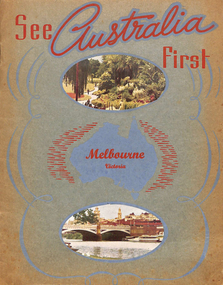
Book, Murray Views, "See Australia First - Melbourne Victoria", c1950
Book - 16 pages, including grey card covers, titled "See Australia First - Melbourne Victoria" featuring 12 pages of postcard photographs of Melbourne. Inside rear cover has a details of Melbourne's history, the city and its features. Produced by Murray Views of Gympie Qld, printed by Samuel Lee and Co. Images post second world war - late 1940's to early 1950's. Features images of: Alexandra Gardens River Yarra and Princes Bridge Flinders St Station St Kilda Road - tram track work being undertaken Flinders St and the Forum theatre The Exhibition Buildings Collins St Parliament House Bourke St - with cable tram tracks and the Metropole Hotel, Myer, Foys Aerial view of Melbourne Captains Cook's Cottage St Kilda Road with W2 287 Burns Memorial St Kilda Road St Paul's and Princes Bridge Town Hall Royal Melbourne Hospital Collins St with W2 turning Queen Victoria Gardenstrams, tramways, melbourne, flinders st station, collins st, town hall, princes bridge, st kilda rd -
 Melbourne Tram Museum
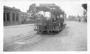
Photograph - Set of 4 Black & White Photograph/s, Don Schulz, mid 1920's
Series of four Black and White Photographs cable trams in Melbourne at the Bridge Road terminus or city during the mid 1920's/ .1 - Bridge road terminus with the car house or depot on the left hand side with the destination of Spencer St. .2 - Gripman possibly checking his watch with a depot worker? stepping off the tram. .3 - family stepping off the tram with cable trailer 368 in the view - Elizabeth St, near Flinders St? See Brian Weedon's notes re the photo and the trailer. .4 - As for .1 - with an X marked above the lady and a very large motor car passing. Printed on Kodak Paper. Adam Chandler advised by email 5/8/2020: " note there's a destination box fitted to the grip - from memory, these started to be used from the mid-1920s with the dummy and trailer repaints into the brown colour? That also looks to be either a 1925 or 26 Buick - the "moustache" shape at the top of the front radiator grille and the distinctly angled lower sash of the windscreen are further hints. Given the Richmond line closed in 1927 for conversion I'd say some time between 1924 and 29 June 1927." Also see image i5.pdf for further notes regarding the photographs and the Bridge Road tram depot building - use the original pdf file to read. Image i6, has had the "X" removed - done by Darren Hutchesson.On rear in ink in each print, "Cable car Melbourne" and "286 Anzac Hy/Marion Rd Adelaide SA, collection of late Don Schultz"trams, tramways, cable trams, bridge road, flinders st, richmond depot, hawthorn bridge, tram 368 -
 Bendigo Military Museum
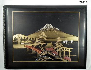
Album - ALBUM, PHOTOGRAPH, Photo Album BCOF Association, c1945-1949
Item is part of the BCOF Association collection. Refer Cat No 7625This is a large photo album. The front and rear covers are made from wood. The basic colour is dark brown. On the front cover is painted a picture of Mt. Fuji, a Japanese village, a bridge and a small building on land, a tree and an archway. Colours are white, gold, red and mauve. It also has a very fine layer of reflective material - possible pearl shell. Inside are a large quantity of Aust soldiers in Japan - postwar. There are tourist type photos as well. Tokyo - Kure - Iwakuni. There are coloured postcards amongst the photos. It also has numerous scenes of Japanese civilian life. There are a few unused pages at the end of the album.ww2, japan, bcof -
 Ballarat Tramway Museum
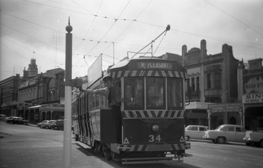
Negative - Black and white print from negative, Travis Jeffrey, c1961
Negative No. N391 and black and white print made by a laser printer (stored in folder) of Ballarat tram No. 34 about to cross Grenville St from Sturt St into Bridge St. Photo has the driver setting the route to control the tram signals for Mt. Pleasant. Photo has the buildings along the north side of Sturt St in the photograph. Date of photo on folder - 5/9/1959, but this is incorrect, as the tram has been fitted with dash canopy lights and tiger stripes, post 1961. Folder and negative could have been mixed up. Original negative rescanned 24/5/2020 and image file updated. Paper folder that contained the negative had "NR8A" in red ink, "BA19" in pencil, date stamp of "5/9/1959" on front, and on rear date stamps "26 Sep 1962" and "26 Sep 1962".trams, tramways, sturt st, grenville st, signals, safeworking, tram 34 -
 Ballarat Tramway Museum
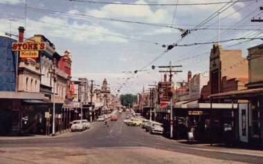
Photograph - Digital Image, Bridge Street
Yields information about the appearance of Bridge St early 1960's and the buildings on either side. Shows the festoon lighting.Digital Copy of a photograph sourced by Roger Greenwood as part of his work on the production of a Video Tape on Ballarat's trams. Photographer and source details not provided by Roger. See btm6304doc.pdf Image looking west along Bridge St Ballarat with the festoon lighting in position. See Reg Item 6303i. This image appears to be early 1960's, possibly a bogie tram with yellow stripping at the Grenville St end, but not the large white stripe. Has the Stones Corner and The State Bank buildings in the view. Photo from a postcard, published c1967 as advised in the e-mail of 20/7/15. Print in box 13 trams, tramways, bridge st, stones corner, main road -
 Melbourne Tram Museum
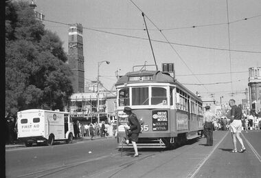
Photograph - Digital Image, changing the points for the cross over in Latrobe St, late 1960's or 1970
Digital image of a photograph from the Ron Scholten Collection of a conductress / conductor changing the points for the cross over in Latrobe St on the east side of Swanston St. The tram has terminated, for a Parade, possibly Moomba during the late 1960's or 1970 as the tram not fitted with side marker lights. In the background is the shot tower with a Penfolds Advert, the Argus building and the ? book Depot. A St Johns ambulance first aid van is parked. The tram has an advert for Queens Bridge Motor Holden and Viva cars (Vauxhall originally) and has a destination of Thornbury - Miller St Tram either SW6 855 or 955.trams, tramways, w6 class, latrobe st, crossover, events, swanston st, thornbury, conductors, conductresses, tram 855, tram 955 -
 Melbourne Tram Museum
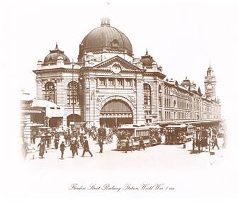
Photograph - Black & White Photograph/s, "Flinders Street Railway Station, World War 1 Era", 1980's?
Reproduced photograph, sepia toned of "Flinders St Railway Station, World War 1 Era, taken from St Paul's Cathedral steps. Has part of the Princes Bridge Station building on the left hand side. The Swanston St canopy of Flinders St station has the words "Enlist and Fight for the Dear Old Flag". Two Richmond line cable trams in Flinders St along with horse drawn vehicles. One of a series of four photographs produced by an unknown person/company. Two sizes of prints held, one large, two small. See also Reg Item 1883 for a 1944 photograph.On the rear of 587 "Cable Tram prints $10/set"trams, tramways, melbourne, flinders st station, world war 1, cable trams -
 St Kilda Historical Society
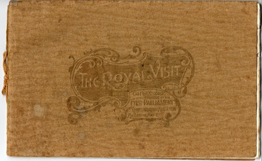
Memorabilia - Booklet, The Royal Visit Celebrations at the Opening of the First Parliament Commonwealth of Australia Melbourne May 1901, 1901
Booklet contains photographs of: THH the Duke and Duchess of Cornwall and York; Earl of Hopetoun, Governor General, and Countess; Commonwealth Ministry; The Royal Party at Government House Melbourne; TRH the Duke and Duchess Landing at St Kilda Pier; The Mayor of Melbourne Welcoming His Royal Highness at the entrance to the City; Procession Passing down Bourke Street; Presentation of War Medals to Victorian Soldiers; The Duke of York and his Staff; St Kilda and Prahran Arch; City Arch; Procession passing Princes Bridge; Opening Ceremony at First Federal Parliament; Citizens' Arch; Queen Victoria Arch; Royal Yacht Ophir; Warships Gromoboi (Russian) and Brooklyn (USA); German Arch; Chinese Arch; State School Fete at Exhibition Building; The University Commencement; Group of Fijian Constabulary; Laying Foundation Stone, Soldiers' Memorial Ballarat; Visit to South Star Gold Mine, Ballarat; Illuminations at Princes Bridge and Flinders Street Station; Illuminations at Parliament House and Treasury; Illuminations at Town Hall and City ArchGold coloured paper cover embossed and tied with gold thread. Contains 16 pages of cream coloured paper printed in black, some with blue decorative margins.Handwritten inscription on title page: 'For the Boy from Grandfather in memory of a very happy time we spent together May 1901'duke and duchess of cornwall and york, royal visits, 1901, opening of parliament, federation arch, st kilda and prahran arch, city arch, german arch, chinese arch -
 Warrnambool and District Historical Society Inc.
Domestic object, Drink Coasters (4)
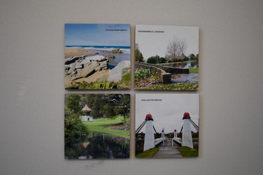
These coasters depict scenes from Warrnambool – the Botanic Gardens, The Hopkins River mouth and the Wollaston Bridge. All are areas of historical and tourist interest. The coaster were produced to raise funds for Peters Project in Warrnambool, a charity organization dedicated to bringing improved cancer care services to Warrnambool. The organization was founded in 2008 by Vicki Jellie in memory of her husband Peter who died of cancer. The major aim of the organization was realized in 2016 when the South West Regional Cancer Care Centre was opened in a new building in Ryot Street and services to assist cancer patients in Warrnambool continue to be extended. These coasters are of some interest as examples of fund-raising material produced by the Peters Project committee to assist with the campaign to bring improved cancer care services to Warrnambool..1 .2.3.4 A wooden drink coaster with a felt base and a colour photograph pasted on the top section.1 Warrnambool Gardens .2 Hopkins River Mouth .3 Wollaston Bridge .4 Warrnambool Gardenspeter’s project, warrnambool, vicki jellie, warrnambool souvenirs -
 Phillip Island Conservation Society Inc.
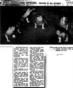
Work on paper - Photocopy of newspaper cutting, Melbourne Sun newspaper, "PHILLIP ISLAND SPECIAL PREPARED BY BILL HITCHINGS", 29.08.1969
This article by journalist Bill Hitchings describes the state of the land market and cost of transporting building materials, Phillip Island, late 1960s. At that stage a number of outlying residential estates had been created, especially on Phillip Island South Coast and at Cowes West. While blocks of land on the outlier estates were very cheap and poorly serviced, the Cowes blocks were selling at $3000 per residential block. Hitchings quotes the owner of the Hollydene motel, Reg Orr, as saying that when the new bridge opens shortly he did not expect it to create a rush of visitors or residents.Bill Hitching was a well-known Melbourne journalist. This article gives an idea of land values on Phillip Island in the late 1960s, the fact that business owners were prepared to upgrade and expand their businesses to cater for extra potential demand on accommodation, and the strong identification of Phillip Island with the Phillip Island Penguin Parade in the minds of the general public in Melbourne. The significance of the new Phillip Island bridge to Phillip Islanders and visitors, and the cost of the bridge, are also outlined. Reg Orr was highly active in the business community of that era on Phillip Island. The Hollydene motel was a well-known Phillip Island accommodation venue.T-shaped article cutting with large image at top of article, dark due to poor photcopy. Double collumn text under photo clearly readable. Black and white.Sun/29/8/6 (?) Probably: Melbourne Sun newspaper, 29 August, 1969phillip island, phillip island tourism, development, hollydene motel, reg orr, phillip island penguin parade, land values, phillip island first bridge, phillip island 2nd bridge, transportation costs -
 Melbourne Tram Museum
Photograph - Photo card Melbourne album sheets 1920c
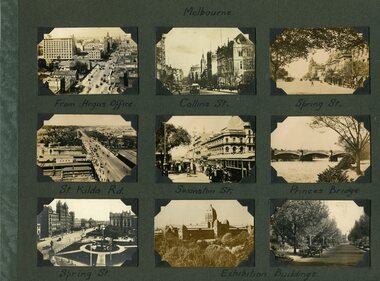
Part of an album of photo cards - cigarette card size - that depicted Melbourne and other country towns c1920. Sheet 1 - Melbourne - Elizabeth St, Collins St, Spring St, St Kilda Rd, Swanston St, Princes Bridge and Exhibition buildings. Sheet 2 - Healesville, Lorne, Brighton, Albury, Bendigo, Woori Yallock and Queenscliff - three cards have been removed prior to acquisition. Sheet 3 - Queen Victoria Gardens, Alexandra Avenue, Exhibition Gardens, St Kilda Road, Botanic Gardens - three cards have been removed prior to acquisition.Set of three album sheets containing up to 9 small printed photos on each sheet of Melbourne and some country towns.melbourne, victoria, tramways, gardens -
 Eltham District Historical Society Inc
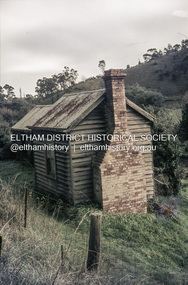
Slide, Pills Cottage, Heidelberg-Kinglake Road, Cottles Bridge, Vic, c.1970
Pills Cottage about halfway from Cottles Bridge to St Andrews near 1575 Heidelberg-Kinglake Road, St Andrews. William John "Bill" Pill was born on 19th June 1894 at Diamond Creek He was brutally murdered on 21st December 1958 age 64, in his cottage. His father was John Henry Pill, born 24 November 1856, Lalone, Perranzabuloe, Cornwall, England, He died 21 December 1930 at Cottles Bridge, His mother was Jessie Ann Whatmough, born 6th June 1870. She died 21 August 1921. William John "Bill '' Pill, grew tomatoes on his rich two and a half acres. In 2024 his second cousin Steve Whatmough recalled visiting Bill in 1957 with his parents (Eric and Nancy Whatmough) and Bill showing them his tomatoes. He had a very large aeroplane propeller set up at one end on his tomato crop. He would run the propeller on frosty mornings to keep away the frost damage. His tomatoes would ripen early and would receive a premium price for them. The cottage consisted of two buildings. The one closest in the right side of the photo was the kitchen. The second building that also has a chimney was his bedroom and living room.35 mm colour positive transparency Mount - Agfacolor Service (Blue)heidelberg-kinglake road, pills cottage, st andrews, william john pill, bill pill, john henry pill, jessie ann pill (nee whatmough), market gardener, murder, cottles bridge (vic.), tomato farm, mount - agfacolor service (blue), scan - 35mm positive -
 Eltham District Historical Society Inc
Slide, Pills Cottage, Heidelberg-Kinglake Road, Cottles Bridge, Vic, c.1970
Pills Cottage about halfway from Cottles Bridge to St Andrews near 1575 Heidelberg-Kinglake Road, St Andrews. William John "Bill" Pill was born on 19th June 1894 at Diamond Creek He was brutally murdered on 21st December 1958 age 64, in his cottage. His father was John Henry Pill, born 24 November 1856, Lalone, Perranzabuloe, Cornwall, England, He died 21 December 1930 at Cottles Bridge, His mother was Jessie Ann Whatmough, born 6th June 1870. She died 21 August 1921. William John "Bill '' Pill, grew tomatoes on his rich two and a half acres. In 2024 his second cousin Steve Whatmough recalled visiting Bill in 1957 with his parents (Eric and Nancy Whatmough) and Bill showing them his tomatoes. He had a very large aeroplane propeller set up at one end on his tomato crop. He would run the propeller on frosty mornings to keep away the frost damage. His tomatoes would ripen early and would receive a premium price for them. The cottage consisted of two buildings. The one closest in the right side of the photo was the kitchen. The second building that also has a chimney was his bedroom and living room.35 mm colour positive transparency Mount - Agfacolor Service (Blue)bill pill, cottles bridge (vic.), heidelberg-kinglake road, jessie ann pill (nee whatmough), john henry pill, market gardener, mount - agfacolor service (blue), murder, pills cottage, scan - 35mm positive, st andrews, tomato farm, william john pill -
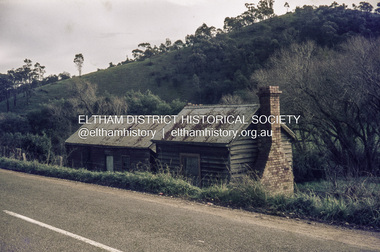
 Eltham District Historical Society Inc
Folder, Eltham Obelisk (later Cenotaph), 1918-2018
The Eltham Obelisk was originally located at the corner of Bridge and Main Roads in 1919. In 1943 (WW2) the local community commenced plans to establish the Eltham War Memorial, a living memorial to benefit the children as opposed to a one in stone as per the obelisk. The Eltham War Memorial Trust was established in 1945. In 1947 the Trust intended for the Obelisk to be relocated from Bridge Street and Main Road to the Garden of Remembrance which was planned as part of the Baby Health Centre which was to be the first of three buildings of the Eltham War Memorial to be built in 1951. In 1951 the Eltham RSL was invited to be represented on the Eltham War Memorial Trust. Around this time, with pending roadworks, the obelisk was relocated to the front garden of the Eltham RSL sub branch on Main Road for safe keeping. In 2007, a suggestion was proposed by Harry Gilham (President, EDHS) to John Cohen (ERSL) to claim a special site along with the historic Shillinglaw trees on the now vacant former Eltham Shire Office site adjacent to the Eltham War Memorial precinct for relocation of the obelisk. In 2010 following the financial collapse and sale of the Eltham RSL Sub-Branch property and amalgamation with the Montmorency Eltham RSL sub-branch, the location of the obelisk was again in immediate jepoardy and in conjunction with Nillumbik Shire Council, the obelisk was relocated in front of the Eltham War Memorial buildings in preparation for the Dawn Service on Anzac Day 2012. Contents: Newspaper article: Eltham Obelisk of 1919, Harry Gilham, August 2000 as well as draft submitted dated 22 Aug 2000 Newspaper article: Eltham, The Advertiser 15 Nov 1918 and 18 Nov 1918 Newspaper article: An Obelisk at Eltham, The Advertiser, 11 Jul 1919 Newspaper advertisement: Unveiling of Obelisk at Eltham, The Advertiser, 1 Aug 1919 Newspaper article: Eltham Soldiers’ Memorial; Unveiled by Sir William Irvine, The Argus, Monday, 4 Aug 1919, p8 Newspaper article: Eltham Memorial to Fallen Soldiers, Diamond Creek Valley Advocate, 8 Aug 1919 Newspaper article: Memorial to the Fallen; Unveiled at Eltham, The Age, Monday, 4th August 1919 Newspaper article: Programme - Presentation of German Machine Gun at the Obelisk, Eltham on Sunday, 8th August, 1920, at 3.30 P.M. Newspaper article: article about presentation of a war trophy, a heavy machine gun placed beside obelisk, The Advertiser, 13 Aug 1920 Newspaper article: Eltham: ANZAC Services, The Advertiser, Friday, May 2, 1924 Newspaper article: Eltham War Memorial, The Advertiser, Oct 26, 1928 Handwritten note from Harry Gilham (President EDHS) to John Cohen (ERSL) regarding history of Eltham RSL site and 1947 newspaper article "Eltham War Memorial Trust "Garden of Remembrance" referencing relocation of Obelisk to the proposed Garden of Remembrance at the Baby Health Centre (Eltham War Memorial). Officers' reports, 11.113/10 Relocation of Eltham RSL Cenotaph, Nillumbik Shire Council Ordinary Meeting, 21 December 2010 Email Correspondence: EDHS President to NSC General Manager Community and Leisure re RSL Obelisk (Cenotaph) proposed relocation, 24 May 2011 Newsletter Extract: Eltham RSL and War Memorial, EDHS Newsletter 14 Sep 2011 Officers' reports, OCM.091/11 Interim Relocation site for the Eltham Cenotaph, Nillumbik Shire Council Ordinary Meeting, 23 August 2011 Officers' reports, OCM.004/121 Interim Relocation of the Eltham Cenotaph, Nillumbik Shire Council Ordinary Meeting, 31 January 2012 (includes Funding agreement between NSC and Montmorency-Eltham RSL Sub-branch Inc) Newspaper article: Move war memorial: RSL, c.2011 Newspaper article: Memorial move lags, Diamond Valley Leader, 1 February 2012 Newspaper article: New dawn for tribute, Diamond Valley Leader ca April 2012 Open letter to the residents of Eltham and Montmorency and copies of drafts by the Montmorency Eltham RSL, no date and final version published in Diamond Valley New 21 March 2012 and Banyule & Nillumbik Weekly, 27 March, 2012 Newspaper article: RSL site nets $1.8m, Diamond Valley Leader, 9 May 2012 Newspaper article: Memorial Moved, Banyule/Nillumbik Weekly, 10 April 2012 Newspaper article: Eltham cenotaph move goes 'like clockwork', Diamond Valley Leader, 11 April 2012 Advertisement, Program for Eltham Dawn Service, Diamond Valley Leader, April 2012 Newspaper photo: Veterans (l-r) Alan Field, Max Lowerson and John Cohen will join piper David Cretney to commemorate fallen Diggers, 2012 (standing beside relocated obelisk in front of the Eltham War Memorial complex) Program for Montmorency Anzac Day March 2012 (incomplete, some pages duplicated, some pages upside down). Newspaper article: Plan to expand memorial, Diamond Valley Leader, Sep. 2004, p5 Newspaper article: Names renewal, thanks to Barry, Diamond Valley Leader, 18 Apr 2007, p3 with picture featuring Eltham RSL president John Haines and Gwen Rosewall Letter: EDHS President to Manager Community Participation, Learning and Culture, Nillumbik Shire Council regarding a proposal by the Montmorency-Eltham RSL Sub-branch to expand the area occupied by the relocated obelisk further into the Eltham War Memorial Garden of Remembrance, 18 Aug 2014 Notices of Motion, NOM.001/14 pertaining to memorials Advisory Committee and Montmorency-Eltham RSL to upgrade the Eltham War Memorial site in time for ANZAC Day 2015, Nillumbik Shire Council Ordinary Meeting, 26 August 2014 Agenda: User Groups and Stakeholders Meeting, Proposed Extension to Memorial Terrace, 11 September 2014 EDHS presentation to NSC Policy and Services meeting 9 September 2014 regarding the Montmorency-Eltham RSL proposal to expand/upgrade the Eltham War Memorial Policy and Services reports, PSD.034/14 Eltham War Memorial Building Precinct - Proposed Extension to Memorial Terrace, Nillumbik Shire Council Ordinary Meeting, 9 September 2014 Email (copy): President EDHS re Eltham War Memorial Complex, Main Road, Eltham, 15 Sep 2014 requesting Nillumbik Shire Council place a Heritage Overlay upon the Eltham War Memorial Complex Media Release: Support for cenotaph expansion, Nillumbik Shire Council, Sep 2014 Newspaper article: Council defers RSL war memorial upgrade to see consultation, Diamond Valley News, 17 Sep 2014 Letter (copy): Harry Gilham, Eltham to local press and others, 20 Sep 2014 protesting attempts by the RSL to further expand upon the area already ceded from the Eltham War Memorial for the relocated WW1 obelisk and alter the original vision for an Eltham War Memorial complex. Letter: Alan Field, President, The Eltham Veterans War Memorial Preservation Society Inc. to CEO and Councillors, Nillumbik Shire Council protesting at perceived injustices and ‘veteran bashing’ regarding their previous efforts to relocate ‘their Obelisk and Cenotaph’ to the Eltham War Memorial complex and their frustration in their attempts to further expand upon the Memorial Terrace. Areas of letter are highlighted with handwritten markups and notes. Also notes on loose card and paper with definitions of Memorial, Obelisk, Cenotaph, commentary on establishment of Eltham War Memorial, The Eltham War Memorial Trust and RSL involvement and current actions by RSL in respect to claims in the letter (written by Harry Gilham ?). Policy and Services reports, PS.038/14 Eltham War Memorial Building Precinct - proposed extension to the Eltham Cenotaph Terrace, Nillumbik Shire Council Policy and Services Committee Meeting, 14 October 2014 Newspaper article: Centenary dawn service moves to Petrie Park, Diamond Valley Leader, 22 Oct 2014 Newspaper article: Upset over upgrade; war memorial revamp plans get culled, Diamond Valley Leader, 29 Oct 2014 Newspaper article: Memories of our heroes, Diamond Valley Leader, 25 Apr 2018 – also Veteran saluted, featuring article on Army veteran, Glen Ferrarotto. Handwritten notes in pencil (2 pages) by Harry Gilham, Items form the Eltham and Whittlesea Shires The Advertiser newspaper 7 June 1918 - 1919 providing a summary of the formation of the Peace Celebration Committee leading to the establishment of the Avenue of Honour and the Eltham Obelisk Newspaper article: Obelisk honors their memory, Diamond Valley News, March 30, 1971, p11eltham cenotaph, nillumbik shire council, eltham war memorial, montmorency eltham rsl sub-branch, dawn service, cenotaph, eltham rsl sub-branch, eltham war memorial trust, garden of remembrance, harry gilham collection, john cohen, obelisk, remembrance garden, shillinglaw trees, german machine gun, war memorial, war trophy -
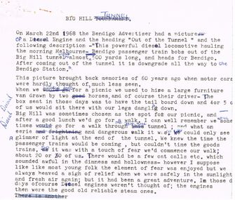 Bendigo Historical Society Inc.
Document - VARIOUS DRAFT ARTICLES FOR RHSV (BENDIGO) NEWSLETTER FEB 1972
Various draft articles for RHSV (Bendigo) Newsletter Feb 1972. 1 Big Hill Tunnel: description of memories by Lydia Chancellor of outings to area (Picnic Day); 2. Article by A W (Lew) Llewellyn re (fist fighting) Champions of England in 1700s and 1800s (incl details of ‘‘Thompson (w.) Bendigo'' - source ''Fistiana, pub. 1857); 3. ''Phenomenal Hail Storm'' by Edith Checcucci(?) description of hail-storm of March 27th, 1914 - hail 18'' thick in Hargreaves Street - describes damage from personal recollection as a child and Annals of Bendigo from March 1914; 4. Note from Neil Murray, President entitled ''Vale - Albert Richardson; obituary and condolences to family; 5. article by ''Jock'' re Chinese Masonic Hall, Bridge Street, and the future of this building describing the nature of the building, uses, owners/occupiers; 6. Handwritten original of #5 - named author; J O'C Hattam (''Jock'')document, newspaper, bendigo advertiser -
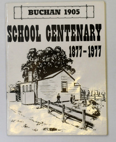 Orbost & District Historical Society
letter book, James Yeates & Sons (Printing) Pty Ltd, 1977
This book was prepared for the Buchan School centenary. In the Buchan District itinerant teaching was conducted in buildings with log walls and a bark roof typical of the mid 19th century. Not until 1878 was the first State school built on the same general site as the present school, on the Orbost Rd, ⅓ of a mile from the bridge over the Buchan River. This original school building must have been constructed from high quality timber, because it still serves as the shelter pavilion. On 11th of July 1878 William Scott opened the first school of approximately 40 pupils ranging from Grade 1 - 8. A larger weatherboard school was erected in 1914. A residence was provided for the HT in 1934 and in 1956 a second classroom erected and attached to the 1914 building. Unfortunately, all records of the Committee were lost in a fire when the homestead of Alex Cameron, then serving as Committee Secretary, was burnt to the ground, but it is well known to local citizens that Frank Moon, local prospector, explorer and discoverer of the famous Buchan Limestone Caves, attended school at SS1905 Buchan. (ref SCHOOLS EAST GIPPSLAND - John Phillips)This book is a useful research tool on the history of Buchan.Two copies of a 273 pp paper covered booklet. The cover is white with the title in black print. On the front is a sketch of an old school building. On the back is a black/white photograph of children running downhill. A book on the history of the Buchan school no.1905. Includes photographs, maps and lists of school students and staff.book buchan-history buchan-school -
 Bendigo Historical Society Inc.
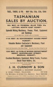
Document - IAN DYETT COLLECTION: AUCTION CATALOGUE - TASMANIAN MINING AND CONTRACTOR'S AUCTION
Beige covered catalogue of Tasmanian Sales by Auction held over three days. On Tuesday 9th May 1944 was an auction of Mining machinery,pumps, plant, equipment and buildings at the Michael Moon Mine, Poimena (Blue Tier) and at the AZ Mine, Poimena (Blue Tier). Thursday 11th May 1944 was the sale of Contractor's Machinery, plant and equipment used in the Construction of the Hobart Bridge by order of the Hobart Bridge Co. Ltd. And Friday 12th May 1944 was the auction of machinery, equipment, motor vehicles etc. at the Public Works Depot at Moonah, Hobart. J. H. Curnow & Son were the Auctioneers. Booklet contains description of some of the machinery, Special Notice regarding travelling and freight, Conditions of Sale and an Auctioneer's Notice mentioning the sale is being conducted by permission of the Director of Machine Tools and Gauges under Regulation 59 of the National Security (General) Regulations. Principals only are allowed to bid and buy unless special permission is granted by DMT & G for some person to act on their behalf, and that person must be an employee of the Firm.business, auctioneers, j h curnow & son pty ltd, ian dyett collection - auction catalogue - tasmanian mining and contractor's auction, michael moon mine, a z mines, hobart bridge co ltd, public works department hobart, j h curnow & son, w c wedd, director of machine tools and gauges, national security (general) regulations, the prahran telegraph printing co, c j curnow, h j lowe, f c dyett, j l jamieson & co -
 Orbost & District Historical Society
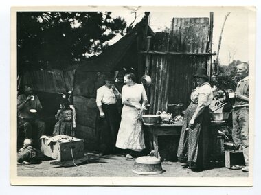
black and white photograph, C1916
This is a photograph of a railway camp, set up to house workers and their families when building the Bairnsdale to Orbost Railway in 1916. The Bairnsdale-Orbost railway was opened in 1916 to serve the agricultural and timber industry. Because of the decline in traffic and heavy operating costs, the line was finally closed in August, 1987. Orbost Railway Station was opened on Monday 10 April 1916 as the terminus of the Orbost railway line, and closed in 1987. The station was located on the west side of the Snowy River despite the town of Orbost being on the east side of the river, in order to save on the costs of a bridge over the river, which at the time had highly variable levels.This item is associated with the history of the Orbost-Bairnsdale railway line and therefore reflects the role that the rail line played in the social and economic history of Orbost.A black / white photograph of a campsite kitchen. The kitchen is outside against a roughly constructed hut. There are three women preparing food. Two men are drinking from tin mugs. a small child is crawling on the ground and another is seated.on back - "Railway Camp"orbost-railway newmerella-railway-camp transport -
 Otway Districts Historical Society
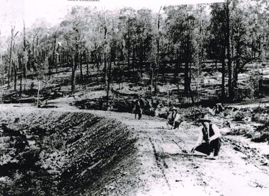
Photograph, Knox Collection, Surveying construction near Barongarook, 1900, 1900
In 1898 a recommendation for a railway of 2 ft 6 in gauge was handed down by the Parliamentary Standing Committee on Railways, to cost $138,000. Construction of the Colac-Beech Forest railway line began in 1900. About 100 men were employed in laying and ballasting the track while others formed the earthworks and the building of culverts and bridges. The earthworks of gravel ballast 150 mm deep were formed by horse and scoop or by shovel. Once the bed had been laid surveyors went along to check the layout, particularly all check rail curves and all 100 metre curves which the surveyors in the picture are doing.B/W. Three men surveying the construction of a curved bed on which track will be laid, near Barongarook, Victoria.colac; beech forest; barongarook; railways; -
 Kew Historical Society Inc
Plan, Melbourne & Metropolitan Board of Works : Borough of Kew : Detail Plan No.1576, 1904
The Melbourne and Metropolitan Board of Works (MMBW) plans were produced from the 1890s to the 1950s. They were crucial to the design and development of Melbourne's sewerage and drainage system. The plans, at a scale of 40 feet to 1 inch (1:480), provide a detailed historical record of Melbourne streetscapes and environmental features. Each plan covers one or two street blocks (roughly six streets), showing details of buildings, including garden layouts and ownership boundaries, and features such as laneways, drains, bridges, parks, municipal boundaries and other prominent landmarks as they existed at the time each plan was produced. (Source: State Library of Victoria)This plan forms part of a large group of MMBW plans and maps that was donated to the Society by the Mr Poulter, City Engineer of the City of Kew in 1989. Within this collection, thirty-five hand-coloured plans, backed with linen, are of statewide significance as they include annotations that provide details of construction materials used in buildings in the first decade of the 20th century as well as additional information about land ownership and usage. The copies in the Public Record Office Victoria and the State Library of Victoria are monochrome versions which do not denote building materials so that the maps in this collection are invaluable and unique tools for researchers and heritage consultants. A number of the plans are not held in the collection of the State Library of Victoria so they have the additional attribute of rarity.Original survey plan, issued by the MMBW to a contractor with responsibility for constructing sewers in the area identified on the plan within the Borough of Kew. The plan was at some stage hand-coloured, possibly by the contractor, but more likely by officers working in the Engineering Department of the Borough and later Town, then City of Kew. The hand-coloured sections of buildings on the plan were used to denote masonry or brick constructions (pink), weatherboard constructions (yellow), and public buildings (grey). Development in the 20th century has irreparably altered that part of Kew represented in this plan. In the block bounded by Cotham Road, Charles Street, Wellington Street and Gellibrand; just one house standing in 1903 remains. This block included two of the most historic houses in Kew: ‘Ordsall’ (later ‘Southesk’) and ‘Madford’ (previously ‘Elm Lodge’). Ordsall was the home of the second chairman of Kew, John Halfey. It contained some of the most significant interior murals in Kew, created for Halfey by artists working for Cullen & Co. It was demolished in 1960 to make way for the Kew Civic Centre. Elm Lodge had been built for William Siddeley in ca. 1864. Arthur Septimus King purchased it in 1874. The lower paddocks of Madford were sold in 1905 by his wife to the Borough of Kew and, after landscaping by George and Thomas Pockett, opened as the Alexandra Gardens in 1908. Elm Lodge/Madford was in 1922 to become St. Anthony’s Home for Little Children before its subsequent demolition in the 1980s.melbourne and metropolitan board of works, detail plans, maps - borough of kew, mmbw 1576, cartography -
 Kew Historical Society Inc
Plan, Borough of Kew Detail Plan No.1577, 1904
The Melbourne and Metropolitan Board of Works (MMBW) plans were produced from the 1890s to the 1950s. They were crucial to the design and development of Melbourne's sewerage and drainage system. The plans, at a scale of 40 feet to 1 inch (1:480), provide a detailed historical record of Melbourne streetscapes and environmental features. Each plan covers one or two street blocks (roughly six streets), showing details of buildings, including garden layouts and ownership boundaries, and features such as laneways, drains, bridges, parks, municipal boundaries and other prominent landmarks as they existed at the time each plan was produced. (Source: State Library of Victoria)This plan forms part of a large group of MMBW plans and maps that was donated to the Society by the Mr Poulter, City Engineer of the City of Kew in 1989. Within this collection, thirty-five hand-coloured plans, backed with linen, are of statewide significance as they include annotations that provide details of construction materials used in buildings in the first decade of the 20th century as well as additional information about land ownership and usage. The copies in the Public Record Office Victoria and the State Library of Victoria are monochrome versions which do not denote building materials so that the maps in this collection are invaluable and unique tools for researchers and heritage consultants. A number of the plans are not held in the collection of the State Library of Victoria so they have the additional attribute of rarity.Original survey plan, issued by the MMBW to a contractor with responsibility for constructing sewers in the area identified on the plan within the Borough of Kew. The plan was at some stage hand-coloured, possibly by the contractor, but more likely by officers working in the Engineering Department of the Borough and later Town, then City of Kew. The hand-coloured sections of buildings on the plan were used to denote masonry or brick constructions (pink), weatherboard constructions (yellow), and public buildings (grey). MMBW Plan No.1577 includes some of the most significant houses in Kew: Herbert Henty’s ‘Roxeth’ (now part of Trinity Grammar), ‘Butleigh Wooton’, ‘Bokara’ and ‘Harrow’. It also includes the streets that have since changed their names. That part of College Parade linked to Glenferrie Road is now named College Place, College Parade now extends further north, and Charles Street did not yet reach Barkers Road. Roxeth is one of a number of Henty houses in Kew. Herbert Henty made his home here and was elected a member of Kew Municipal Council in 1864 and mayor in 1868-69. Walter Henry Serle, of Harrow served in the First World War. He was awarded the Military Medal ‘’For conspicuous bravery and devotion to duty. On 29th September near BELLICOURT he showed the greatest bravery and determination when his platoon was attacked by enemy bombing parties. It was due largely to his personal efforts that all the attacks were repulsed. Until wounded, his utter disregard of personal safety and boldness in dealing with the attacks were the means of saving the situation and were an inspiring example to his men.’melbourne and metropolitan board of works, detail plans, maps - borough of kew, mmbw 1577, cartography -
 Kew Historical Society Inc
Plan, Melbourne & Metropolitan Board of Works : Borough of Kew : Detail Plan No.1578, 1904
The Melbourne and Metropolitan Board of Works (MMBW) plans were produced from the 1890s to the 1950s. They were crucial to the design and development of Melbourne's sewerage and drainage system. The plans, at a scale of 40 feet to 1 inch (1:480), provide a detailed historical record of Melbourne streetscapes and environmental features. Each plan covers one or two street blocks (roughly six streets), showing details of buildings, including garden layouts and ownership boundaries, and features such as laneways, drains, bridges, parks, municipal boundaries and other prominent landmarks as they existed at the time each plan was produced. (Source: State Library of Victoria). This plan forms part of a large group of MMBW plans and maps that was donated to the Society by the Mr Poulter, City Engineer of the City of Kew in 1989. Within this collection, thirty-five hand-coloured plans, backed with linen, are of statewide significance as they include annotations that provide details of construction materials used in buildings in the first decade of the 20th century as well as additional information about land ownership and usage. The copies in the Public Record Office Victoria and the State Library of Victoria are monochrome versions which do not denote building materials so that the maps in this collection are invaluable and unique tools for researchers and heritage consultants. A number of the plans are not held in the collection of the State Library of Victoria so they have the additional attribute of rarity.Original survey plan, issued by the MMBW to a contractor with responsibility for constructing sewers in the area identified on the plan within the Borough of Kew. The plan was at some stage hand-coloured, possibly by the contractor, but more likely by officers working in the Engineering Department of the Borough and later Town, then City of Kew. The hand-coloured sections of buildings on the plan were used to denote masonry or brick constructions (pink), weatherboard constructions (yellow), and public buildings (grey). MMBW Plan No.1578 is significant in that it defines the extent of two private schools: Xavier College and Kew High School (now part of Trinity Grammar) by 1904. In relation to the latter, the plan clarifies which buildings the High School operated from behind the mansion ‘Molina’. Established in 1902, Trinity Grammar was to later lease and subsequently buy Molina (now ‘Merritt House’) and ‘Elsinore’ (now ‘Roberts House’). Xavier College had been established in 1872. This 1904 plan delineates the West Wing and the Great Hall (built in 1890).melbourne and metropolitan board of works, detail plans, maps - borough of kew, mmbw 1578, cartography -
 Kew Historical Society Inc
Plan, Melbourne & Metropolitan Board of Works. Borough of Kew Detail Plan No.1579, 1904
The Melbourne and Metropolitan Board of Works (MMBW) plans were produced from the 1890s to the 1950s. They were crucial to the design and development of Melbourne's sewerage and drainage system. The plans, at a scale of 40 feet to 1 inch (1:480), provide a detailed historical record of Melbourne streetscapes and environmental features. Each plan covers one or two street blocks (roughly six streets), showing details of buildings, including garden layouts and ownership boundaries, and features such as laneways, drains, bridges, parks, municipal boundaries and other prominent landmarks as they existed at the time each plan was produced. (Source: State Library of Victoria). This plan forms part of a large group of MMBW plans and maps that was donated to the Society by the Mr Poulter, City Engineer of the City of Kew in 1989. Within this collection, thirty-five hand-coloured plans, backed with linen, are of statewide significance as they include annotations that provide details of construction materials used in buildings in the first decade of the 20th century as well as additional information about land ownership and usage. The copies in the Public Record Office Victoria and the State Library of Victoria are monochrome versions which do not denote building materials so that the maps in this collection are invaluable and unique tools for researchers and heritage consultants. A number of the plans are not held in the collection of the State Library of Victoria so they have the additional attribute of rarity.Original survey plan, issued by the MMBW to a contractor with responsibility for constructing sewers in the area identified on the plan within the Borough of Kew. The plan was at some stage hand-coloured, possibly by the contractor, but more likely by officers working in the Engineering Department of the Borough and later Town, then City of Kew. The hand-coloured sections of buildings on the plan were used to denote masonry or brick constructions (pink), weatherboard constructions (yellow), and public buildings (grey). While MMBW Plan No.1579 does not include many buildings, those that it does show are significant to Kew’s history. These include the ‘Kew [Railway] Station’ in Denmark Street and the ‘Recreation Hall’ and rear courts off Wellington Street. The plan shows the outline of the Recreation Hall, constructed in 1880, at the rear of which is listed a bowling green, two tennis courts, a ‘skittle alley’ and a pavilion. When the Hall was first built, the Kew Cricket Club occupied an adjacent ground, however in 1885 this was acquired by the State Government as the future location of the Kew Railway Station. The Plan also shows a single oval at Xavier College. This oval was completed in 1883. One of the current ovals conforms to this oval’s original shape and position in the school grounds.melbourne and metropolitan board of works, detail plans, maps - borough of kew, mmbw 1579, cartography -
 Kew Historical Society Inc
Plan, Melbourne and Metropolitan Board of Works, Borough of Kew : Detail Plan No.1580, 1904
The Melbourne and Metropolitan Board of Works (MMBW) plans were produced from the 1890s to the 1950s. They were crucial to the design and development of Melbourne's sewerage and drainage system. The plans, at a scale of 40 feet to 1 inch (1:480), provide a detailed historical record of Melbourne streetscapes and environmental features. Each plan covers one or two street blocks (roughly six streets), showing details of buildings, including garden layouts and ownership boundaries, and features such as laneways, drains, bridges, parks, municipal boundaries and other prominent landmarks as they existed at the time each plan was produced. (Source: State Library of Victoria)This plan forms part of a large group of MMBW plans and maps that was donated to the Society by the Mr Poulter, City Engineer of the City of Kew in 1989. Within this collection, thirty-five hand-coloured plans, backed with linen, are of statewide significance as they include annotations that provide details of construction materials used in buildings in the first decade of the 20th century as well as additional information about land ownership and usage. The copies in the Public Record Office Victoria and the State Library of Victoria are monochrome versions which do not denote building materials so that the maps in this collection are invaluable and unique tools for researchers and heritage consultants. A number of the plans are not held in the collection of the State Library of Victoria so they have the additional attribute of rarity.Original survey plan, issued by the MMBW to a contractor with responsibility for constructing sewers in the area identified on the plan within the Borough of Kew. The plan was at some stage hand-coloured, possibly by the contractor, but more likely by officers working in the Engineering Department of the Borough and later Town, then City of Kew. The hand-coloured sections of buildings on the plan were used to denote masonry or brick constructions (pink), weatherboard constructions (yellow), and public buildings (grey). The area represented in this detail plan has undergone significant change during the 20th century. The widening of High Street in the 1930s and 1950s involved the shops on the south side of High Street being demolished and later rebuilt to fit the widened street. Another significant loss was the mansion ‘Drayton’ fronting Wellington Street, owned at this stage by Susannah Fenton. Her family name would later to be given to Fenton Way, which was to be built over the grounds of the house following its demolition. The plan of the garden is particularly interesting, containing a batten dome fronting Wellington Street, an ornamental pond, a fountain and a brick and glass conservatory. The notes by the plumbing contractor on this plan are particularly detailed. Pink borders delineate the ownership of the varying parcels of land. Some of the better known owners listed include the real estate agent Cr. Henry de Castres Kellett (bt) and John Padbury, the funeral director. This particular plan provides a clear view of the configuration of the Kew Junction in 1903 and the commercial buildings that surrounded it.melbourne and metropolitan board of works, detail plans, maps - borough of kew, mmbw 1580, cartography -
 Kew Historical Society Inc
Plan, Melbourne & Metropolitan Board of Works : Borough of Kew : Detail Plan No.1581, 1904
The Melbourne and Metropolitan Board of Works (MMBW) plans were produced from the 1890s to the 1950s. They were crucial to the design and development of Melbourne's sewerage and drainage system. The plans, at a scale of 40 feet to 1 inch (1:480), provide a detailed historical record of Melbourne streetscapes and environmental features. Each plan covers one or two street blocks (roughly six streets), showing details of buildings, including garden layouts and ownership boundaries, and features such as laneways, drains, bridges, parks, municipal boundaries and other prominent landmarks as they existed at the time each plan was produced. (Source: State Library of Victoria)This plan forms part of a large group of MMBW plans and maps that was donated to the Society by the Mr Poulter, City Engineer of the City of Kew in 1989. Within this collection, thirty-five hand-coloured plans, backed with linen, are of statewide significance as they include annotations that provide details of construction materials used in buildings in the first decade of the 20th century as well as additional information about land ownership and usage. The copies in the Public Record Office Victoria and the State Library of Victoria are monochrome versions which do not denote building materials so that the maps in this collection are invaluable and unique tools for researchers and heritage consultants. A number of the plans are not held in the collection of the State Library of Victoria so they have the additional attribute of rarity.Original survey plan, issued by the MMBW to a contractor with responsibility for constructing sewers in the area identified on the plan within the Borough of Kew. The plan was at some stage hand-coloured, possibly by the contractor, but more likely by officers working in the Engineering Department of the Borough and later Town, then City of Kew. The hand-coloured sections of buildings on the plan were used to denote masonry or brick constructions (pink), weatherboard constructions (yellow), and public buildings (grey). The streets and built structures in this plan were surveyed in 1903 and released to contractors in 1904. In addition to the designation of building types by colour, the plan includes detailed descriptions of land use and ownership. While many buildings remain from this period, a number of the buildings represented have been demolished including the original Kew Town Hall, and the Congregational and Roman Catholic churches in Walpole Street. While the mansion ‘Illapa’ in Princess Street is still extant – now part of ‘Rylands’ – the neighbouring mansion ‘Elsmere’ was demolished some decades ago. Rivalling Illapa and Elsmere in size were two mansions in Walpole Street, one named on the plan as ‘Gnarlbine’. Over time, Kew Junction and the south side of High Street have been reconfigured and widened, so that the commercial buildings on the corner of Princess and High Street no longer exist. A surprising feature of this part of central Kew to the northwest of Kew Junction is the amount of vacant land. In a number of cases, this land is noted by the contractor as used for vegetable gardens.melbourne and metropolitan board of works, detail plans, maps - borough of kew, mmbw 1581, cartography -
 Kew Historical Society Inc
Plan, Melbourne & Metropolitan Board of Works : Borough of Kew : Detail Plan No.1582, 1904
The Melbourne and Metropolitan Board of Works (MMBW) plans were produced from the 1890s to the 1950s. They were crucial to the design and development of Melbourne's sewerage and drainage system. The plans, at a scale of 40 feet to 1 inch (1:480), provide a detailed historical record of Melbourne streetscapes and environmental features. Each plan covers one or two street blocks (roughly six streets), showing details of buildings, including garden layouts and ownership boundaries, and features such as laneways, drains, bridges, parks, municipal boundaries and other prominent landmarks as they existed at the time each plan was produced. (Source: State Library of Victoria)This plan forms part of a large group of MMBW plans and maps that was donated to the Society by the Mr Poulter, City Engineer of the City of Kew in 1989. Within this collection, thirty-five hand-coloured plans, backed with linen, are of statewide significance as they include annotations that provide details of construction materials used in buildings in the first decade of the 20th century as well as additional information about land ownership and usage. The copies in the Public Record Office Victoria and the State Library of Victoria are monochrome versions which do not denote building materials so that the maps in this collection are invaluable and unique tools for researchers and heritage consultants. A number of the plans are not held in the collection of the State Library of Victoria so they have the additional attribute of rarity.Original survey plan, issued by the MMBW to a contractor with responsibility for constructing sewers in the area identified on the plan within the Borough of Kew. The plan was at some stage hand-coloured, possibly by the contractor, but more likely by officers working in the Engineering Department of the Borough and later Town, then City of Kew. The hand-coloured sections of buildings on the plan were used to denote masonry or brick constructions (pink), weatherboard constructions (yellow), and public buildings (grey). Public buildings, coloured grey on the Plan 1582 include the police station and post office, churches and schools. The earliest church school, Common School No.356 was located at the rear of the Congregational Church in Peel Street. It was constructed in 1859. The first buildings of Kew Primary School No.1075 on the other side of Peel Street were constructed in 1871. The school in 1903 only occupied a small fraction of its current site. In 1903, where the rear playground is now located, were two weatherboard and one brick villa. Trinity Grammar School was founded in 1902 and opened in the Parish Hall at the rear of Holy Trinity Anglican Church. It was not to move to its current site until 1906. The outline of the building housing the Kew Fire Brigade in the centre of the north side of Walton Street is shown but not named on the plan. Further down Pakington Street stood the two-storey Italianate mansion ‘Overton’. The home of Stanford Chapman, it was to be featured in the Imperial Institute series of bromide photographs of Victoria, Vol. 1: Homes and scenery. It was later to become a boarding house before it was later demolished.melbourne and metropolitan board of works, detail plans, maps - borough of kew, mmbw 1582, cartography -
 Kew Historical Society Inc
Plan, Melbourne & Metropolitan Board of Works : Borough of Kew : Detail Plan No.1585, 1904
The Melbourne and Metropolitan Board of Works (MMBW) plans were produced from the 1890s to the 1950s. They were crucial to the design and development of Melbourne's sewerage and drainage system. The plans, at a scale of 40 feet to 1 inch (1:480), provide a detailed historical record of Melbourne streetscapes and environmental features. Each plan covers one or two street blocks (roughly six streets), showing details of buildings, including garden layouts and ownership boundaries, and features such as laneways, drains, bridges, parks, municipal boundaries and other prominent landmarks as they existed at the time each plan was produced. (Source: State Library of Victoria)This plan forms part of a large group of MMBW plans and maps that was donated to the Society by the Mr Poulter, City Engineer of the City of Kew in 1989. Within this collection, thirty-five hand-coloured plans, backed with linen, are of statewide significance as they include annotations that provide details of construction materials used in buildings in the first decade of the 20th century as well as additional information about land ownership and usage. The copies in the Public Record Office Victoria and the State Library of Victoria are monochrome versions which do not denote building materials so that the maps in this collection are invaluable and unique tools for researchers and heritage consultants. A number of the plans are not held in the collection of the State Library of Victoria so they have the additional attribute of rarity.Original survey plan, issued by the MMBW to a contractor with responsibility for constructing sewers in the area identified on the plan within the Borough of Kew. The plan was at some stage hand-coloured, possibly by the contractor, but more likely by officers working in the Engineering Department of the Borough and later Town, then City of Kew. The hand-coloured sections of buildings on the plan were used to denote masonry or brick constructions (pink), weatherboard constructions (yellow), and public buildings (grey). This plan, which covers parts of High Street, Pakington Street and Derby Street is dominated by two historic Kew mansions: ‘Konetta’ and ‘Ramornie’. Ramornie was constructed in 1890 for James Maitland Campbell, three times Mayor of Kew. Sold in 1940, it became a boarding house known as ‘The Towers’. Now a private residence again, it has only one of its three balconies remaining. The location of the missing two balconies can be seen on the plan. In 1903, the grounds of Ramornie included a large tennis court fronting Pakington Street. The rear of the property is shown as extending to Cobden Street. One of Kew’s oldest hotels, the Prospect Hill Hotel on the corner of High and Cobden Street was established in 1858. The outline of the hotel shown on the plan represents the second building on the site. During the 19th century it was often used for electoral meetings. The Prospect Hill Hotel was to be redeveloped again in 1928, by the local architect Robert McIntyre. Since the 1980s, the hotel has been a live music venue, the home of the Melbourne Jazz Club, a restaurant and a liquor outlet.melbourne and metropolitan board of works, detail plans, maps - borough of kew, mmbw 1585, cartography -
 Kew Historical Society Inc
Plan, Melbourne & Metropolitan Board of Works : Borough of Kew : Detail Plan No.1588, 1904
The Melbourne and Metropolitan Board of Works (MMBW) plans were produced from the 1890s to the 1950s. They were crucial to the design and development of Melbourne's sewerage and drainage system. The plans, at a scale of 40 feet to 1 inch (1:480), provide a detailed historical record of Melbourne streetscapes and environmental features. Each plan covers one or two street blocks (roughly six streets), showing details of buildings, including garden layouts and ownership boundaries, and features such as laneways, drains, bridges, parks, municipal boundaries and other prominent landmarks as they existed at the time each plan was produced. (Source: State Library of Victoria)This plan forms part of a large group of MMBW plans and maps that was donated to the Society by the Mr Poulter, City Engineer of the City of Kew in 1989. Within this collection, thirty-five hand-coloured plans, backed with linen, are of statewide significance as they include annotations that provide details of construction materials used in buildings in the first decade of the 20th century as well as additional information about land ownership and usage. The copies in the Public Record Office Victoria and the State Library of Victoria are monochrome versions which do not denote building materials so that the maps in this collection are invaluable and unique tools for researchers and heritage consultants. A number of the plans are not held in the collection of the State Library of Victoria so they have the additional attribute of rarity.Original survey plan, issued by the MMBW to a contractor with responsibility for constructing sewers in the area identified on the plan within the Borough of Kew. The plan was at some stage hand-coloured, possibly by the contractor, but more likely by officers working in the Engineering Department of the Borough and later Town, then City of Kew. The hand-coloured sections of buildings on the plan were used to denote masonry or brick constructions (pink), weatherboard constructions (yellow), and public buildings (grey). This plan shows the original configuration of the Kew Post Office, Court House and Police Station, which had opened in 1888. This configuration was to essentially remain until the purchase of the Court House and Police Station by the City of Boroondara in 2007 and its subsequent renovation. Interestingly, the MMBW surveyors incorrectly labelled parts of the complex. In the triangle in front of the Post Office, before the erection of the Kew Cenotaph in 1925, was located a lawn and the Queen Victoria Jubilee Fountain. While many of the shops on the south side of High street had been constructed by 1903 a number of sites were still used as vegetable gardens. Further along High Street, on the corner of Charles Street, the Salvation Army Barracks can be seen on the plan. These Barracks predate the later Citadel and ‘Young People’s Hall’ that were opened in 1919. At 22 Charles Street can be seen the house of James Venn Morgan. Hailed as the ‘father of Kew’, Morgan arrived in Melbourne in 1840. He was first engaged as a bookmaker, but a fortunate venture on the goldfields enabled him to purchase land in Kew. He conducted a market garden and dairy in Kew for many years.melbourne and metropolitan board of works, detail plans, maps - borough of kew, mmbw 1588, cartography -
 Kew Historical Society Inc
Plan, Melbourne & Metropolitan Board of Works : Borough of Kew : Detail Plan No.1590, 1905
The Melbourne and Metropolitan Board of Works (MMBW) plans were produced from the 1890s to the 1950s. They were crucial to the design and development of Melbourne's sewerage and drainage system. The plans, at a scale of 40 feet to 1 inch (1:480), provide a detailed historical record of Melbourne streetscapes and environmental features. Each plan covers one or two street blocks (roughly six streets), showing details of buildings, including garden layouts and ownership boundaries, and features such as laneways, drains, bridges, parks, municipal boundaries and other prominent landmarks as they existed at the time each plan was produced. (Source: State Library of Victoria)This plan forms part of a large group of MMBW plans and maps that was donated to the Society by the Mr Poulter, City Engineer of the City of Kew in 1989. Within this collection, thirty-five hand-coloured plans, backed with linen, are of statewide significance as they include annotations that provide details of construction materials used in buildings in the first decade of the 20th century as well as additional information about land ownership and usage. The copies in the Public Record Office Victoria and the State Library of Victoria are monochrome versions which do not denote building materials so that the maps in this collection are invaluable and unique tools for researchers and heritage consultants. A number of the plans are not held in the collection of the State Library of Victoria so they have the additional attribute of rarity.Original survey plan, issued by the MMBW to a contractor with responsibility for constructing sewers in the area identified on the plan within the Borough of Kew. The plan was at some stage hand-coloured, possibly by the contractor, but more likely by officers working in the Engineering Department of the Borough and later Town, then City of Kew. The hand-coloured sections of buildings on the plan were used to denote masonry or brick constructions (pink), weatherboard constructions (yellow), and public buildings (grey). Surveyed by the Board of Works in 1903 and published in 1904, Plan No.1590 shows development north of Cotham Road. While this plan includes built structures in Mary Street, Cotham Road, High Street, Park Hill Road, Kent Street, Ridgeway Avenue, and Ermington Lane (now Ermington Place), only part of this section was notated and coloured in this contractor’s copy. Numerous houses, large and small are named on the plan: ‘Cholula’, ‘Belper’, ‘The Uplands’, ‘Spring Grove’ facing Cotham Road; ‘Marion’ facing Kent Street; and ‘Kia Ora’ facing Ridgeway Avenue.melbourne and metropolitan board of works, detail plans, mmbw 1590, survey plans - borough of kew, cartography -
 Kew Historical Society Inc
Plan, Melbourne & Metropolitan Board of Works : Borough of Kew : Detail Plan No.1591, 1905
The Melbourne and Metropolitan Board of Works (MMBW) plans were produced from the 1890s to the 1950s. They were crucial to the design and development of Melbourne's sewerage and drainage system. The plans, at a scale of 40 feet to 1 inch (1:480), provide a detailed historical record of Melbourne streetscapes and environmental features. Each plan covers one or two street blocks (roughly six streets), showing details of buildings, including garden layouts and ownership boundaries, and features such as laneways, drains, bridges, parks, municipal boundaries and other prominent landmarks as they existed at the time each plan was produced. (Source: State Library of Victoria)This plan forms part of a large group of MMBW plans and maps that was donated to the Society by the Mr Poulter, City Engineer of the City of Kew in 1989. Within this collection, thirty-five hand-coloured plans, backed with linen, are of statewide significance as they include annotations that provide details of construction materials used in buildings in the first decade of the 20th century as well as additional information about land ownership and usage. The copies in the Public Record Office Victoria and the State Library of Victoria are monochrome versions which do not denote building materials so that the maps in this collection are invaluable and unique tools for researchers and heritage consultants. A number of the plans are not held in the collection of the State Library of Victoria so they have the additional attribute of rarity.Original survey plan, issued by the MMBW to a contractor with responsibility for constructing sewers in the area identified on the plan within the Borough of Kew. The plan was at some stage hand-coloured, possibly by the contractor, but more likely by officers working in the Engineering Department of the Borough and later Town, then City of Kew. The hand-coloured sections of buildings on the plan were used to denote masonry or brick constructions (pink), weatherboard constructions (yellow), and public buildings (grey). That area of Kew bordered by Cotham Road, Park Hill Road, Ermington Lane (now Ermington Place), and Belmont Avenue contained some of the significant homes owned by Kew pioneers. Chief among these was ‘Park Hill’ on an enormous lot facing Park Hill Road. The Jubilee History of 1910 noted, six years after this plan was drawn, that: ‘Park Hill Road, forming the southern boundary of the cemetery, takes its name from Park Hill, the residence of Mr. Thomas Judd, who has resided there since December, 1852.’ Other named houses on the plan include ‘Ferndale’ facing Cotham Road; ‘Ermington’ adjacent to Judd’s Park Hill, facing Park Hill Road; and ‘Gilden’ and ‘Mont Belmont’ facing Belmont Avenue. Mont Belmont was designed by the architectural firm of Reed, Henderson and Smart for William George Lilley in 1887 and was completed in 1888. Lilley was Mayor of Kew in 1887-88, a Justice of the Peace and a member of the first Board of Guardians of Kew’s St. Hilary’s Church of England.melbourne and metropolitan board of works, detail plans, survey plans - borough of kew, mmbw 1591, cartography