Showing 697 items
matching bullock
-
 Stawell Historical Society Inc
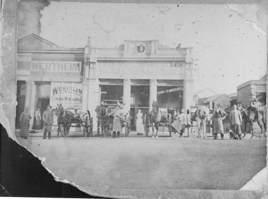
Photograph, Chaponnel, Bush and Allen Butcher’s Shop in Main Street Stawell built 1876
Chaponnel Bush and Allen Butcher’s Shop Main Street Stawell built 1876. Butchers in aprons and horse drawn carts lined up in the street in front Note the Bullocks Head in centre of Parapet. Also Wertheim Sewing Machines on building beside it.stawell business streetscape -
 Lakes Entrance Historical Society
Photograph - Bob Hodgson pioneer skills enthusiast and proprietor of Lyrebird Motel Lakes Entrance Victoria, Lakes Post Newspaper, 1/12/1992 12:00:00 AM
Bob Hodgson pioneer skills enthusiast and proprietor of Lyrebird Motel Lakes Entrance Victoria .Also a black and white photograph of Bob Hodgson with four of his bullocks pulling a wooden sled number 3905.1 size 12 x 15 cmBlack and white photograph of Bob Hodgson pioneer skills enthusiast and proprietor of Lyrebird Motel Lakes Entrance Victoriabusinesses, farm, animals -
 Charlton Golden Grains Museum Inc
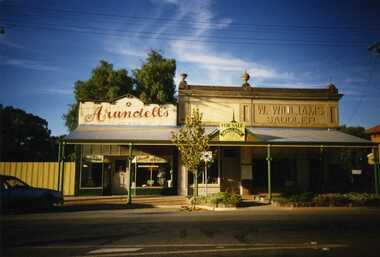
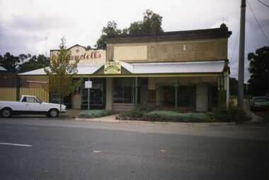
Photograph, Brownjohn, Reg, Charlton High Street 1988, 1988
Photo taken by R. Brownjohn in 1988 of three shops in the centre of High St, Charlton. Arundell's shoe shop, former Stock & Station Agency and Williams Saddlery (later Bullocks Grocery). The buildings were later demolished to become the Traveller's RestColour photograph of Vic Arundell's Shoe Shop, and former W. Williams Saddlery shop. For Sale sign over centre building. car parked in left of photo. East Charlton Hotel in background on RH side of photo.bullocks grocery, saddlery, williams, arundell, shoe shop, business -
 Otway Districts Historical Society
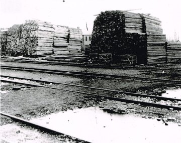
Photograph, Knox Collection, Beech Forest: timber stacks, 1906, 1906
Beech Forest was the principal despatch centre for split timber and mining laths in 1906, most of which was carried to the railway yards by bullock wagons, or a horse-hauled wooden tramline along the Olangolah Road to the east of the town. At the yards it awaited trans-shipment by rail.B/w. 190mm x 265mm. Timber stacked in the Beech Forest railway yard. Four roads passing. A goods shed in the background. beech forest; railways; -
 Charlton Golden Grains Museum Inc
Photograph, Brownjohn, Reg, Charlton High Street 1988, c.1988
Charlton High Street centre 1988. Vic Arundell's Shoe Shop, Stock & Station Agent and former W. Williams Saddlery (later Bullock's Grocery). Buildings latr demolished to become the Traveller's Rest. Williams St renamed John Curtin Drive.Colour photograph of Vic Arundell's shop and former W. Williams Saddlery on the corner of High St and Williams St. For Sale sign over the middle building. White ute parked in front of Arundell's. Another ute parked at side of buildings.bullocks grocery, business, industry, high street, arundell, shoe shop, saddlery, w. williams -
 Lakes Entrance Historical Society
Postcard, 1930c
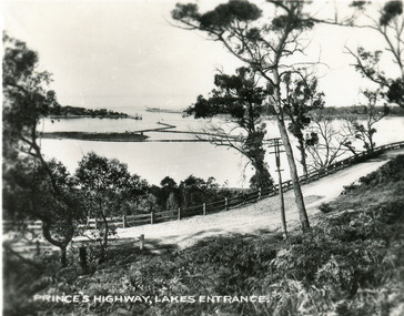
Also faded copy identical imageBlack and white small format postcard of the Princes Highway at Jemmys Point. It shows the road winding around the hill between the scrub covered hill and the post and rail guard fence, Bullock Island and rock groynes in the lake also entrance in distance. Lakes Entrance VictoriaPrinces Highway, Lakes Entranceislands, fences, roads and streets -
 Lakes Entrance Historical Society
Photograph - Tarpeena, Hammarstrom Ian, 1986 c
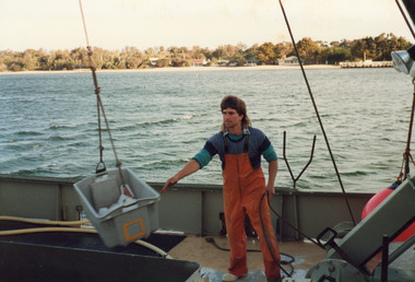
Colour photograph taken on the deck of fishing boat Tarpeena at Co-op jetty, Bullock Island, shows deck hand Gerald Rice at work during unloading of catch from fish well. Cunninghame Arm and New Works cottages in image. Lakes Entrance Victoriaships and shipping, fishing industry, people -
 Lakes Entrance Historical Society
Photograph - Township, Fish Marie, 1985c
Colour photograph of township, showing building on Bullock Island, Cunningham Arm and small white shed on old New Works Jetty near the entrance, view towards the barrier. Photo taken from near telecom tower on Merrangbaur Hill 1985c. Lakes Entrance Victoriatopography, township, waterways, bridges -
 Lakes Entrance Historical Society
Postcard - Views of Lakes Entrance c1970, John Engelander and Co Melbourne, 1970 c
Princes Highway to town showing concrete bridge over North Arm . Also identical postcard with message on back in Spares boxColour postcard of view from Princes Highway to town showing concrete bridge over North Arm old toilet block opposite road to Bullock Island, Club Spit being formed, Hill 60 visible on outer barrier hummocks Lakes Entrance Victoriaislands, people, recreational facilities, roads and streets -
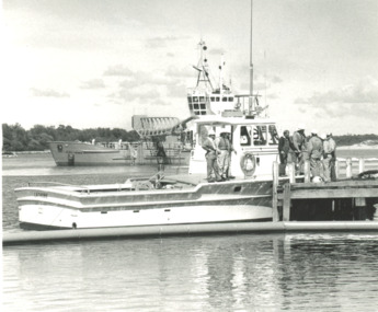 Lakes Entrance Historical Society
Photograph, Lakes Post Newspaper, Gippsland Ports vessel Latrobe Lakes Entrance Victoria, 1/11/1995 12:00:00 AM
Black and white photograph of Gippsland Ports vessel Latrobe and crew taken on training day for Oil Spill disaster. Dredge April Hamer in background both moored at Bullock Island Lakes Entrance Victoria. Also photograph taken during Oil Spill disaster activities gippsland ports, events -
 Lakes Entrance Historical Society
Photograph, Glenice Soderlund, Lady Harriet barge, Lakes Entrance Victoria, 1/06/1989 12:00:00 AM
Colour photograph showing Lady Harriet barge moored at wharf in Cunninghame Arm mast and rigging intact. Bullock Island and sand dunes in background Lakes Entrance Victoria. Also an enlarged colour lamenated photograph almost identical 04673.1 29 x 19.5 cmbarges, boats and boating -
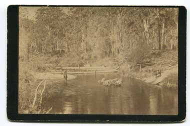 Orbost & District Historical Society
black and white photograph, late 19th - early 20th century
In the late 1800's early 1900's transporting goods by road was difficult and at times impossible because roads as thoroughfares did not exist.The means of travelling along the roads in the 1800's was by bullock wagon, horse pulled dray, pack horse or simply by foot. This is a pictorial record of transport in the mid 18th - early 19th century. Pack horses were vital for the delivery of goods, responding to emergencies as they could travel in country inaccessible to larger horse - drawn carts or wagons.A black / white photograph on a black buff card. It is of a group of pack horses being guided across a waterway with a man on horseback on either side of the river.transport pack-horses -
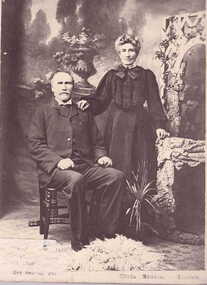 Clunes Museum
photograph, WAUGH
GINNY WAUGH [NEE ROBBINS] WAS THE FIRST WHITE CHILD BORN IN CLUNES. SHE AND HER HUSBAND, SAMUEL, ARE BURIED IN THE CLUNES CEMETERY. HER FATHER WAS HARRY ROBBINS WHO WAS THE FIRST MAN TO TAKE A LOAD OF GOLD QUARTZ FROM CLUNES TO BALLARAT BY BULLOCK WAGON.PHOTOGRAPH OF SAMUEL AND GINNY WAUGH. IT IS MOUNTED ON MASONITE.local history, photography, photographs, early citizens -
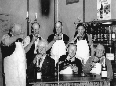 Stawell Historical Society Inc
Photograph, Seppelts Workers wine tasting 1950
Seppelts Workers wine tasting – 1950Black and Withe photgraph of Seven Men with white aprons and wine glassessipping champagne. four of the men are standing with three seated in front of a table with two bottles and ttwo canndle sticks.On the rear of the photgraph is a typed note: Seppelt Cellars Great Western November 1950 Standing: Jim Harris, Charlie Bullock, Harold Carr, Joe Tozer. Seated: Stan Wathen. Leo Hurley, Warren Taylor.great western, wine making, seppelts -
 Bendigo Historical Society Inc.
Map - CAMPBELL COLLECTION: BENDIGO & DISTRICT MAPS
Map. Lockwood, Parishes of Lockwood and Shelbourne. Scale 20 chains to 1 inch.Total area 4405 acres. Bullock Creek to the right, Spring Creek at Centre. Newbridge is 11 miles N E, To Marong, Bendigo Lockwood roads are on the left. (number 375 in map cupboard 1)map, bendigo, agricultural lands -
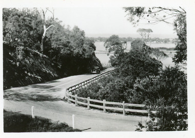 Lakes Entrance Historical Society
Postcard - Princes Highway Kalimna, 1940c
Plus 3 identical black and white|Plus 2 tinted, (one tinted copy has inscription, 'Jemmy's Point')Black and white small format postcard of the road as it winds around Jemmys Point. It shows a motor car travelling up the hill between the steep cliff of the road cutting and the post and rail guard fence. Glimpse of Bullock Island, lake and hummocks in distance. Lakes Entrance Victoriafences, roads and streets, transport, coast -
 Lakes Entrance Historical Society
Photograph - Carpentertown, 1920c
Copied from a copy in possession of J WhadcoatBlack and white photograph showing view of seven cottages on dunes. View of several boats at jetties and on slipway, white shed on New Works wharf, Cunninghame Arm in front of cottages, part of Bullock Island showing some vegetation and one telegraph pole. Lakes Entrance Victoriawaterways, islands, settlement -
 Lakes Entrance Historical Society
Photograph - The Entrance, Fraser Ian, 1995c
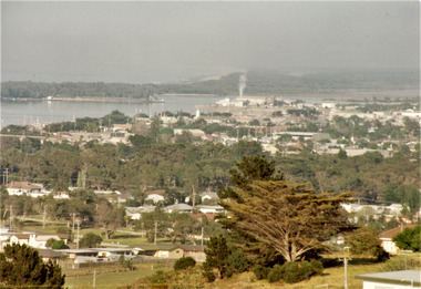
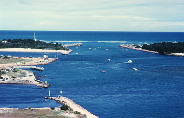
Colour photograph of the entrance from Bass Strait to the Gippsland Lakes. It shows the western end of Bullock Island and the entrance to North Arm, cars parked on island and many people fishing. This area built up during dredging operations over many years. Lakes Entrance Victoria topography, fishing industry, boats and boating -
 Lakes Entrance Historical Society
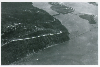
Photograph - Kalimna, Bulmer H D, 1940c
Black and white photograph of aerial view of Kalimna Heights, showing scattered buildings, Princes Highway around side of cliff, western end of township, North Arm bridge, footbridge to Bullock Island, and rock groynes. Track to lookout and signal beacon visible. Lakes Entrance Victoria waterways, roads and streets, bridges, township -
 Lakes Entrance Historical Society
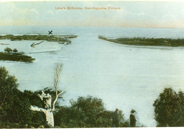
Postcard - The Entrance, 1900c
Also copy tinted postcard 10 x 15Coloured post card of the man made entrance through the sand dunes, taken from Jemmys Point. It shows the works and settlement at the entrance, Bullock Island and groynes to direct flow of lake waters towards entrance. Two men standing on Jemmys Point. Lakes Entrance VictoriaLakes Entrance, Cunninghame, Victoriaislands, waterways, topography -
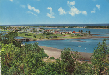
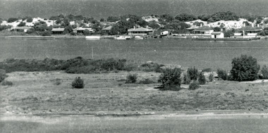
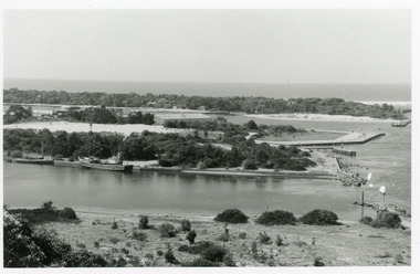
 Lakes Entrance Historical Society
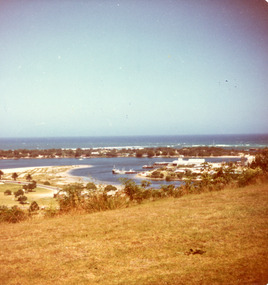
Photograph - Bullock Island, Fraser Ian, 1975c
Color photograph of the eastern part of Bullock Island, showing buildings of Lakes Entrance Fishing Co-Operative and PWD, spit opposite Club Hotel has been sown with grass, hummocks and Bass Strait in distance. Taken from Seaview Parade Kalimna. Lakes Entrance Victoriawaterways, islands, land reclamation, topography -
 Lakes Entrance Historical Society
Photograph - Bullock Island, 1990c
Black and white photograph of the entrance. It shows two fishing boats moored in North Arm, western end of Bullock Island with Fishermens Co-op building, and area below Jemmys Point, both formed during dredging operations over many years. Lakes Entrance Victoria waterfront, islands -
Glen Eira Historical Society
Document - Liscard St, 9, Elsternwick
A typed copy of a one-page report dated 16 May 1988 by H. Bullock and Rosalind Landells of Brighton Historical Society regarding the history and occupany of 9 Liscard Street, Elsternwick from 1888-1974. An undated hand-written note of the same information is included.liscard street, glen eira road, elsternwick, doyle estelle mrs, trew william tracey, cobbledick f.j. mrs, larsen rasmur j., johnson e. mrs, larsen bertha mrs, larsen roy, corkhill, depression 1890s -
 Stawell Historical Society Inc
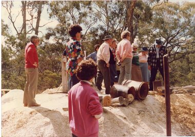
Photograph, Joe Mitchell's Mine
Stawell Historical Society Members visit Joe Mitchell's mine in the Ironbark, forest near Deep Lead. L to R Ian Jackson, Carmel Loats, Thelona Bullock, Allan Kingston, Betty Jackson, Betty Collins, Dorothy King, Leslie Bennett, Lawrie Bennett.Colour Photograph of a Group of people standing, looking down a mine shaft in bushland.mining, gold mininging, stawell historical society, deep lead -
Glen Eira Historical Society
Document - Dairies
This file contains two items: 1/A handwritten description of Margaret Bullock’s memories of the area where Sheridan’s dairy and house were in Kooyong Road, and of Lempriere’s Paddock. 2/A photocopied extract from Caulfield’s heritage vol. 1 by Dr. Gewlah Solomon on Joseph Sheridan.sheridan, dairies, hospital, car park, sheridan’s paddocks, north road, bluestone, sheridan’s cottage, lempriere estate, white flett, berkley hospital, the little company of mary, bethlehem hospital, bullock margaret, stewart margaret, gardenvale road, kooyong road, sheridan joseph, dairyman, mansions, dairy farms, sheridan t. j., sheridan thomas, elsternwick, dairying -
 Port of Echuca
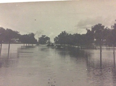
A black and white postcard, 1906. or. 1916
The postcard is significant because it shows the extent of the flood in the early 20th Century. The bridge crosses the Southern Cross channel which had been built as part of the Murray Darling irrigation system. There is a vehicle on the bridge either being towed by bullocks or horses. Floodwaters cover the whole view.The postcard is significant because it shows the extent of the flood in the early 20th Century. The bridge crosses the Southern Cross channel which had been built as part of the Murray Darling irrigation system. It is also near the water filtration plant which filters the town's water supply. There is a vehicle on the bridge either being towed by bullocks or horses. Floodwaters cover the whole view.A black and white postcard showing Goulburn Road, Echuca East, in either the 1906, or 1916 floods.Printed on the back are the words; W. Grimwood Echuca. POST CARD. Correspondence Address Only Kodak Australia. Hand written on the back are the words 1906 or 1916? Southern Cross bridge near filtration plant. Goulburn Road, Echuca East.floods, goulburn road, echuca east, pullicino, j, postcard, southern cross channel, water filtration plant -
 Kiewa Valley Historical Society
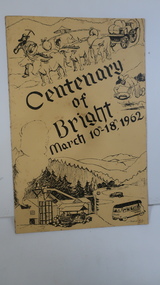
Booklet - Bright, Centenary of Bright March 10th - 18th, 1962
Township of Bright celebrated its centenary during the week from 10th - 18th March, 1962. This booklet outlines the program for the week.Bright is a nearby town to the the Kiewa Valley and currently the location of the current Shire (Alpine). The program gives historical information on activities in the early 1960s.Yellowy/Orange cover with brown title and sketch. One sketch is at the bottom and includes hills, pines, saw mill and bus. Sketch at the top is of a bullock team and in the middle on the right a gold miner. Inside cover has print as has both sides of the 4 pages held by 2 staples. 'C. Roper' on inside of the front cover.bright, centenary of bright -
Bendigo Historical Society Inc.
Map - BRIDGEWATER : COUNTY OF BENDIGO, 6-10-27
Map. Bridgewater, County of Bendigo, Inglewood, Salisbury, Derby, Leichardt, Yarraberb, Yarrayne, Bullock Creek, Loddon River, Sandhurst and Inglewood Railway. Photo-Lithographed at the Department of Lands and Survey Melbourne by W.J. Butson, 6-10-27. Price 1/-. (number 53 in map cupboard 1)W.J. Butsonmap, bendigo, bridgewater -
Port Melbourne Historical & Preservation Society
Postcard - Swallow & Ariell promotion, On the Road
"On the Road" Coloured postcard, front shows a bullock team and dray in front of a bark hut. Large gum tree on right and hills behind. Back shows Swallow & Ariell's renowned biscuits and cakes, pure jams and canned fruits. Plum puddings and Australian seeded raisins etc. are the bestindustry - food, swallow & ariell ltd -
 Bendigo Historical Society Inc.
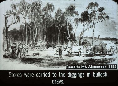
Slide - DIGGERS & MINING. STORES AT THE DIGGINGS, c1852
Diggers & Mining. Stores at the diggings. Road to Mt. Alexander, 1852. Stores were carried to the diggings in bullock drays. Slide shows travellers with swags and drays pulled by ox, with stores also a horse pulling a dray with supplies. Markings: 37 994.LIF. 5. Used as a teaching aid.hanimounteducation, tertiary, goldfields