Showing 663 items
matching bullocks
-
 Otway Districts Historical Society
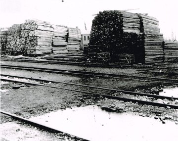
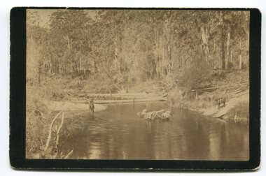
Photograph, Knox Collection, Beech Forest: timber stacks, 1906
Beech Forest was the principal despatch centre for split timber and mining laths in 1906, most of which was carried to the railway yards by bullock wagons, or a horse-hauled wooden tramline along the Olangolah Road to the east of the town. At the yards it awaited trans-shipment by rail.B/w. 190mm x 265mm. Timber stacked in the Beech Forest railway yard. Four roads passing. A goods shed in the background. beech forest; railways; -
 Charlton Golden Grains Museum Inc
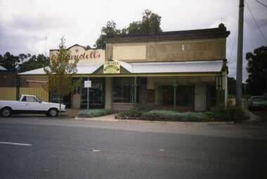
Photograph, Charlton High Street 1988
Charlton High Street centre 1988. Vic Arundell's Shoe Shop, Stock & Station Agent and former W. Williams Saddlery (later Bullock's Grocery). Buildings latr demolished to become the Traveller's Rest. Williams St renamed John Curtin Drive.Colour photograph of Vic Arundell's shop and former W. Williams Saddlery on the corner of High St and Williams St. For Sale sign over the middle building. White ute parked in front of Arundell's. Another ute parked at side of buildings.high st, vic arundell's shoes, w.williams saddlery, bullocks grocery -
 Federation University Historical Collection
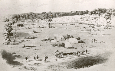
Photograph - Photograph - black and white, William Strutt, View of Golden Point, Ballarat, Taken from West
The lithograph is held by the State Library of Victoria. Printed below the image is Lithographed by Campbell & Macartney. The title is beneath image and continues: 'Respectfully dedicated to the inhabitants of Victoria / By their obedient servant / Wm. Strutt.'Photograph of a lithograph of view of the Golden Point - Ballarat by William Strutt. The Golden Point goldfield at Ballarat is depicted with a number of people congregated along a creek (Yarrowee Creek), some tents, stockyards evident, a butcher's shambles (tent) a bullock dray, three aborigines and a number of 'diggers' walking towards the goldfield are evident.ballarat, golden point, william strutt, ballarat townscape, mining, goldfield -
 Lakes Entrance Regional Historical Society (operating as Lakes Entrance History Centre & Museum)
Photograph, Lakes Entrance Tidy Town, 1995 c
Colour photograph showing two children and an adult riding bicycles on pathway between south end of North Arm bridge and Bullock Island road. Middle distance left turn into Marine Parade foreground now site of skate park. In distance palm trees at entry to Esplanade Lakes Entrance Victoriarecreation -
Lakes Entrance Regional Historical Society (operating as Lakes Entrance History Centre & Museum)
Photograph, 1900 c
Myrtle Fish collection daughter of George Price GrantSepia toned photograph showing large Bullock team of George Price Grant of Metung moving a small building in Metung district four men visible one on right with an axe other with whips. Bare hill and a few dead trees in background showing early land improvement for agriculture Metung Victoriaschools, postal services, genealogy -
 Lakes Entrance Regional Historical Society (operating as Lakes Entrance History Centre & Museum)
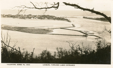
Postcard
Black and white postcard of west end of Bullock Island, showing rock groynes around island, wooden entrance piers in entrance to Gippsland Lakes from Bass Strait, sand dunes showing New Works houses and sheds. A tree branch across top and foreground shrubbery. Lakes Entrance VictoriaLooking towards Lakes Entrance (on front)islands, waterways, bridges, township, room display -
 Lakes Entrance Regional Historical Society (operating as Lakes Entrance History Centre & Museum)
Photograph, 1924c
Black and white photograph showing view from Jemmys Point of the entrance, with wooden piers, PWD houses and works buildings at New Works. West end of Bullock Island on left side of photo, bathing boxes and some trees on island, some rock groyne work at the entrance. Lakes Entrance Victoriawaterfront, boats and boating, houses, jetties -
 Bendigo Historical Society Inc.
Slide - DIGGERS & MINING. THE GOLD ERA, c1850s
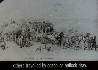
Diggers & mining. The gold era. - - - others travelled by coach or bullock dray. Slide shows a dray pulled by 4 ox, a coach pulled by 4 horses, men on horseback, and men on foot one with a wheel barrow. There are also several dogs. Markings 14 994.031 GOL:5. Used as a teaching aid.hanimounteducation, tertiary, goldfields -
Bendigo Historical Society Inc.
Map - POMPAPIEL : COUNTY OF BENDIGO, 1-10-27
Map. Pompapiel, County of Bendigo, Calivil, Janiember East, Yarrayne, Salisbury, Yallook, Talambe, Judyong Creek, Bullock Creek, Pompapiel Creek, Edeyrn Estate. Photo-Lithographed at the Department of Lands and Survey, Melbourne by W.J. Butson, 1-10-27, Price 1/-. (number 4 in map cupboard 1)W.J. Butson, Government Printermap, bendigo, pompapiel -
 Bendigo Historical Society Inc.
Photograph - BENDIGO CEMETERY: CARPENTER STREET, 1861
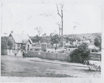
black and white photo: stone building at left with central porch, 1 chimney, large sign '.. Cemetery' Tall dead tree at rear. Graves with headstones, treed hill at back. 2 bullocks with chain at front right. At left near gate, 2 children, adult male. In image B.R. Batchelder.Batchelderplace, cemetery, bendigo cemetery, carpenter street -
 Greensborough Historical Society
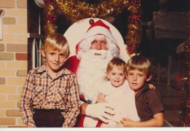
Photograph - Digital image, David and Daniel Black and Katie Elizabeth Bullock, 1970s
Part of a collection of photographs copied from the late Shirley Fraser (nee Black), also descendant of the McLaughlin family. This photograph shows David Black (age 8 years), Daniel Black (6 years) and Katie Elizabeth Bullock (1 year) on a visit to Santa.Digital copy of colour photograph.shirley fraser, david black, daniel black, katie elizabeth bullock -
 Orbost & District Historical Society
black and white photograph, late 19th - early 20th century
In the late 1800's early 1900's transporting goods by road was difficult and at times impossible because roads as thoroughfares did not exist.The means of travelling along the roads in the 1800's was by bullock wagon, horse pulled dray, pack horse or simply by foot. This is a pictorial record of transport in the mid 18th - early 19th century. Pack horses were vital for the delivery of goods, responding to emergencies as they could travel in country inaccessible to larger horse - drawn carts or wagons.A black / white photograph on a black buff card. It is of a group of pack horses being guided across a waterway with a man on horseback on either side of the river.transport pack-horses -
 Clunes Museum
photograph - PHOTOGRAPH - WAUGH
GINNY WAUGH [NEE ROBBINS] WAS THE FIRST WHITE CHILD BORN IN CLUNES. SHE AND HER HUSBAND, SAMUEL, ARE BURIED IN THE CLUNES CEMETERY. HER FATHER WAS HARRY ROBBINS WHO WAS THE FIRST MAN TO TAKE A LOAD OF GOLD QUARTZ FROM CLUNES TO BALLARAT BY BULLOCK WAGON.PHOTOGRAPH OF SAMUEL AND GINNY WAUGH. IT IS MOUNTED ON MASONITE.local history, photography, photographs, early citizens -
 Stawell Historical Society Inc
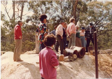
Photograph, Joe Mitchell's Mine
Stawell Historical Society Members visit Joe Mitchell's mine in the Ironbark, forest near Deep Lead. L to R Ian Jackson, Carmel Loats, Thelona Bullock, Allan Kingston, Betty Jackson, Betty Collins, Dorothy King, Leslie Bennett, Lawrie Bennett.Colour Photograph of a Group of people standing, looking down a mine shaft in bushland.mining, gold mininging, stawell historical society, deep lead -
Glen Eira Historical Society
Document - Dairies
This file contains two items: 1/A handwritten description of Margaret Bullock’s memories of the area where Sheridan’s dairy and house were in Kooyong Road, and of Lempriere’s Paddock. 2/A photocopied extract from Caulfield’s heritage vol. 1 by Dr. Gewlah Solomon on Joseph Sheridan.sheridan, dairies, hospital, car park, sheridan’s paddocks, north road, bluestone, sheridan’s cottage, lempriere estate, white flett, berkley hospital, the little company of mary, bethlehem hospital, bullock margaret, stewart margaret, gardenvale road, kooyong road, sheridan joseph, dairyman, mansions, dairy farms, sheridan t. j., sheridan thomas, elsternwick, dairying -
Glen Eira Historical Society
Document - Liscard St, 9, Elsternwick
A typed copy of a one-page report dated 16 May 1988 by H. Bullock and Rosalind Landells of Brighton Historical Society regarding the history and occupany of 9 Liscard Street, Elsternwick from 1888-1974. An undated hand-written note of the same information is included.liscard street, glen eira road, elsternwick, doyle estelle mrs, trew william tracey, cobbledick f.j. mrs, larsen rasmur j., johnson e. mrs, larsen bertha mrs, larsen roy, corkhill, depression 1890s -
 Stawell Historical Society Inc
Photograph, The Reef Hotel Pleasant Creek 1858 - 1861 -- note, no Bullock team as in Rees painting
The Reefs Hotel Pleasant Creek. 1858 - 1861 (note, no Bullock team as in Rees painting) Three windlasses over mineshafts can be seen, two on the left and one in front of the assembly hall. Some horse driven Whims can be seen in the background above the Assembly Hall.One of earliest known photographs of Pleasant CreekSeveral buildings in mining area with trees in background, one building labelled The Reefs Hotel. Spoil heaps in foreground with other mining activities . Number of people visible in street.stawell -
Bendigo Historical Society Inc.
Map - POMPAPIEL : COUNTY OF BENDIGO, 1-10-27
Map. Pompapiel, County of Bendigo, Calivil, Talambe, Yallook, Salisbury, Yarrayne, Janiember East, Waranga Mallee Channel, Blind Creek, Judyong Creek, Bullock Creek. Photo-Lithographed at the Dept. of Lands and Survey Melbourne by W.J. Butson 1-10-27. Price 1/-. (number 85 in map cupboard 1)W.J. Butsonmap, bendigo, pompapiel -
Bendigo Historical Society Inc.
Map - POMPAPIEL : COUNTY OF BENDIGO, 1-10-27
Map. Pompapiel, County of Bendigo, Calivil, Talambe, Yallook, Salisbury, Yarrayne, Janiember East, Waranga Mallee Channel, Judyong Creek.Pompapiel Creek, Bullock Creek, Blind Creek. Photo-Lithographed at the Department of Lands and Survey by W.J. Butson, 1-10-27. Price 1/-. (number 84 in map cupboard 1)W.J. Butson.map, bendigo, pompapiel -
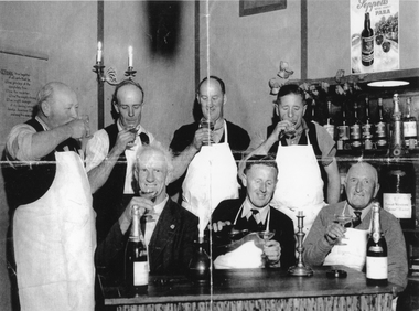 Stawell Historical Society Inc
Photograph, Seppelts Workers wine tasting 1950
Seppelts Workers wine tasting – 1950Black and Withe photgraph of Seven Men with white aprons and wine glassessipping champagne. four of the men are standing with three seated in front of a table with two bottles and ttwo canndle sticks.On the rear of the photgraph is a typed note: Seppelt Cellars Great Western November 1950 Standing: Jim Harris, Charlie Bullock, Harold Carr, Joe Tozer. Seated: Stan Wathen. Leo Hurley, Warren Taylor.great western, wine making, seppelts -
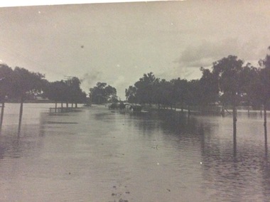 Port of Echuca
A black and white postcard, 1906. or. 1916
The postcard is significant because it shows the extent of the flood in the early 20th Century. The bridge crosses the Southern Cross channel which had been built as part of the Murray Darling irrigation system. There is a vehicle on the bridge either being towed by bullocks or horses. Floodwaters cover the whole view.The postcard is significant because it shows the extent of the flood in the early 20th Century. The bridge crosses the Southern Cross channel which had been built as part of the Murray Darling irrigation system. It is also near the water filtration plant which filters the town's water supply. There is a vehicle on the bridge either being towed by bullocks or horses. Floodwaters cover the whole view.A black and white postcard showing Goulburn Road, Echuca East, in either the 1906, or 1916 floods.Printed on the back are the words; W. Grimwood Echuca. POST CARD. Correspondence Address Only Kodak Australia. Hand written on the back are the words 1906 or 1916? Southern Cross bridge near filtration plant. Goulburn Road, Echuca East.floods, goulburn road, echuca east, pullicino, j, postcard, southern cross channel, water filtration plant -
Lakes Entrance Regional Historical Society (operating as Lakes Entrance History Centre & Museum)
Photograph, H D Bulmer, 1930 c
Black and white photograph of lower section of Princes Highway around Jemmys Point, car parked on road at junction of original steep road to top of Jemmys Point. Man on bicycle riding up hill. Bullock Island and New Works in distance over North Arm and Cunninghame Arm waterways Lakes Entrance Victoriaroads and streets, township, waterways -
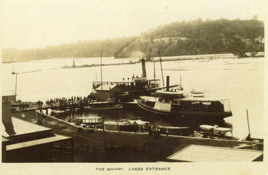 Lakes Entrance Regional Historical Society (operating as Lakes Entrance History Centre & Museum)
Photograph, 1910 c
Black and white photograph showing two steamers at New Works wharf, five or six other smaller vessels and crowds of people on wharf and steamers. Small shed on end of wharf, rooves of two buildings in foreground. Jemmys Point hill in the background and timber barrier wall for formation of Bullock Island. Lakes Entrance Victoria.The Wharf, Lakes Entranceships and shipping, township, waterways, retail trade -
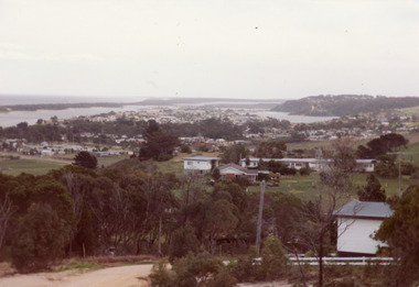 Lakes Entrance Regional Historical Society (operating as Lakes Entrance History Centre & Museum)
Photograph
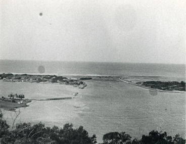
Colour photograph of township of Lakes Entrance showing North Arm, North Arm Bridge, Jemmys Point, Mount Barclay, Kalimna Heights, Cunningham Arm and sand dunes on left. Looking west to Bullock Island and Rigby Island. Photo taken from near Telecom Tower on Merrangbaur Hill. Lakes Entrance Victoriaconstruction, bridges, waterways -
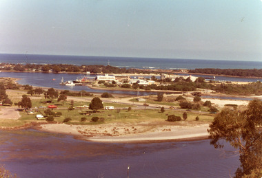 Lakes Entrance Regional Historical Society (operating as Lakes Entrance History Centre & Museum)
Photograph, Holding George, 1975c
Colour photograph of Bullock Island showing Pecks fish processing factory Lakes Entrance Fishing Co-Operative, and PWD buildings, vehicles on picnic area of Marine Parade during one and only offshore power boat race. Spit opposite Club Hotel has grass and some bushes. Lakes Entrance Victoriaislands, land reclamation, waterways -
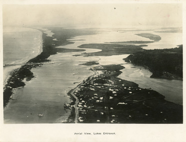 Lakes Entrance Regional Historical Society (operating as Lakes Entrance History Centre & Museum)
Postcard, 1923c
Also large postcard 15 x 20|Also two mini postcard 6 x 9|Also copy black and white 9 x 14.5Black and white postcard of an aerial view of township of Lakes Entrance, showing western end of town, jetties and boat harbours in Cunninghame Arm, the entrance and piers, North Arm bridge, Bullock Island, Rigby, Fraser and Flannegan Islands, and a distant view of Boole Poole, Bunga Arm and Lake King. Lakes Entrance VictoriaAn aerial view showing position of Lakes Entranceaerial photograph, islands, waterways, topography -
 Bendigo Historical Society Inc.
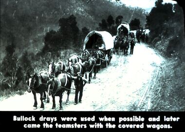
Slide - DIGGERS & MINING. DIGGERS AND MINERS, c1800s
Diggers & Mining. Diggers and miners. Walhalla - Gold Town. Bullock drays were used when possible and later came the teamsters with the covered wagons. Picture shows 3 covered wagons pulled by teams of eight horses. Men with the wagons. On a track carved into a mountain. Markings: 13 995 WAL. Used as a teaching aid.hanimounteducation, tertiary, goldfields -
Glen Eira Historical Society
Document - Jasper Road, 321, Ormond
A copy of a two page research report on 321 Jasper Road, Ormond by Hilary Bullocks and Rosalind Landells of the Brighton Historical Society, dated 08/11/1996. The report provides a brief history of the property and its occupancy. The file also includes one page of their handwritten, undated working notes.bick david, landells rosalind, bullocks hilary, bentleigh, ormond, jasper road, glengarry villa, raveloe, moorabbin, hallinan family, garrett minnie, hallinan frank, ellin albert, hannaford harry j, chatts julius, o’loughlin kath, o'loughlan kath, o’loughlin e, o'loughlan e mrs, martin albert v, perry c v, phelan leo a, perry albert e, jones robert h, jackson a, schools -
 Lakes Entrance Regional Historical Society (operating as Lakes Entrance History Centre & Museum)
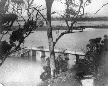
Photograph, 1920c
Other photographs in album of this area dated 1928Black and white photograph of the North Arm Bridge, taken from Kalimna Heights looking towards the Entrance and Bullock Island. Bridge has no side rails, appears to be chain and wire between concrete posts. Sedan car passing over the bridge. The walking track to Kalimna Heights visible right foreground. Lakes Entrance Victoriabridges, waterways, transport -
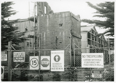 Lakes Entrance Regional Historical Society (operating as Lakes Entrance History Centre & Museum)
Photograph, Lakes Post Newspaper, 1995
This image appeared in Lakes Post 21 May 1995Black and white photograph of Pecks fish processing factory on Bullock Island, during demolition. It shows a building clad with asbestos cement sheets, and a partly demolished brick tower, enclosed by cyclone wire fence and gates with eight warning signs attached. Health and safety issues were paramount during demolition. Lakes Entrance Victoriaislands, machinery, topography