Showing 2065 items
matching burke
-
 Cheese World Museum
Book, Spectrum Print Solutions, Pioneering Dairy Families, May 2013
Book developed from the Heritage Week 2011 display featuring some pioneering farming families connected with Warrnambool Cheese and Butter Factory Ltd. The book was printed and launched at the 125th Anniversary celebrations of the factory in May 2013. Families featured are Anderson, Burke, Burleigh, Chislett, Kelly, Logan, Mahony, McConnell, Rea, Taylor, Uebergang.Records the contribution of early dairy farming families connected with Victoria's oldest dairy processing manufacturer. The company was established in May 1888 and commenced commercial processing in November 1888. The company remained as an independent processor until early 2014.White cloth bound book with chrome screw binding, green and cream Warrnambool Cheese and Butter Factory Company logo and title in green print; 12 laminated pages, full colour. Book printer details on sticker on inside back cover.Spectrum Print Solutions/for all your printing needs/Shop2,377 Raglan Pde, Warrnambool/Ph 03 5561 5233 www.spectrum-oz.comdairying, dairy processors, milk, butter, cheese, families, anderson, burke, burleigh, kelly, logan, mahony, mcconnell, rea, taylor, uebergang, warrnambool cheese and butter factory company, wcb, anniversary celebrations -
 The Beechworth Burke Museum
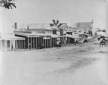
Photograph, 1859
Taken in Beechworth 1859, this photograph depicts the south side of Ford street looking towards the Methodist Church. The Methodist Church was built in 1857, and was the first permanent church building on the Ovens goldfields. It was one of the first permanent churches built on the Victorian goldfields, and the first on the Ovens goldfield. It demonstrates the rapid development which occurred in the goldfield towns following the discovery of gold in the early 1850s. It reflects the importance of Methodism in Victoria at this time, and the early activities of the Wesleyan Methodist Church in taking their religious message to the gold miners. [https://vhd.heritagecouncil.vic.gov.au/places/104] The buildings ceased being used as a church in 1966 when the Methodist and Congregational churches in Beechworth amalgamated.Black and white rectangular photograph. Image is printed on matte photographic paper. Obverse: NO INSCRIPTION Reverse: 7775 Ford St Looking Southwest 1859 Burke Museum Beechworth beechworth, ford street, methodist church, 1859 -
 Melbourne Tram Museum
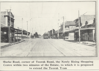
Photograph - Black & White Photograph/s, 1970's
Black and white copy photograph from a Real Estate Poster of a tram in Burke Road, Camberwell, at corner of Toorak Road. Has title on photograph "Burke Road, corner of Toorak Road, the Newly Rising Shopping Centre within two minutes of the Estate, to which it is proposed to extend the Toorak Tram" Street lighting suspended off the tramway overhead. Tram is a single trucker in the PMTT numbering livery.trams, tramways, mmtb, pmtt, burke rd, toorak rd -
 Kew Historical Society Inc
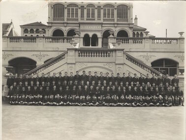
Photograph, Students of Xavier Preparatory School, 1960s
This work forms part of the collection assembled by the historian Dorothy Rogers, that was donated to the Kew Historical Society by her son John Rogers in 2015. The manuscripts, photographs, maps, and documents were sourced by her from both family and local collections or produced as references for her print publications. Many were directly used by Rogers in writing ‘Lovely Old Homes of Kew’ (1961) and 'A History of Kew' (1973), or the numerous articles on local history that she produced for suburban newspapers. Most of the photographs in the collection include detailed annotations in her hand. The Rogers Collection provides a comprehensive insight into the working habits of a historian in the 1960s and 1970s. Together it forms the largest privately-donated collection within the archives of the Kew Historical Society.An undated school photograph of the students of Xavier Preparatory School in Nolan Avenue, Kew. The photograph is taken outside the entrance to Burke Hall (earlier named Waverley, then Studley Hall).studley hall, burke hall, xavier preparatory school, dorothy rogers -
 Kew Historical Society Inc
Plan - Subdivision Plan, Birdwood Estate, 1920
Pru Sanderson, in her groundbreaking ‘City of Kew Urban Conservation Study : Volume 2 - Development History’ (1988), summarised the periods of urban development and subdivisions of land in Kew. The periods that she identified included 1845-1880, 1880-1893, 1893-1921, 1921-1933, 1933-1943, and Post-War Development. These periods were selected as they represented periods of rapid growth or decline in urban development. An obvious starting point for Sanderson’s groupings involved population growth and the associated economic cycles. These cycles also highlighted urban expansion onto land that was predominantly rural, although in other cases it represented the decline and breakup of large estates. A number of the plans in the Kew Historical Society’s collection can also be found in other collections, such as those of the State Library of Victoria and the Boroondara Library Service. A number are however unique to the collection.The Kew Historical Society collection includes almost 100 subdivision plans pertaining to suburbs of the City of Melbourne. Most of these are of Kew, Kew East or Studley Park, although a smaller number are plans of Camberwell, Deepdene, Balwyn and Hawthorn. It is believed that the majority of the plans were gifted to the Society by persons connected with the real estate firm - J. R. Mathers and McMillan, 136 Cotham Road, Kew. The Plans in the collection are rarely in pristine form, being working plans on which the agent would write notes and record lots sold and the prices of these. The subdivision plans are historically significant examples of the growth of urban Melbourne from the beginning of the 20th Century up until the 1980s. A number of the plans are double-sided and often include a photograph on the reverse. A number of the latter are by noted photographers such as J.E. Barnes.Bordering Burke Road, the Birdwood Estate included a subdivision of 34 lots on either side of Birdwood Street, Balwyn. Six of the lots faced Burke Road. At the other end of the subdivision a line would indicate that a creek once bordered the subdivision. Lots were advertised for sale at a low figure on five-year terms. Purchasers could pay off the balance in twenty quarterly instalments (i.e. over five years).subdivision plans - balwyn, birdwood estate -
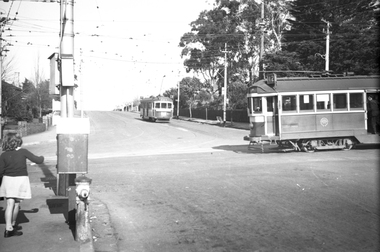 Melbourne Tram Museum
Negative, Wal Jack, 24/07/1944 12:00:00 AM
Black and white negative, by Wal Jack, of W2 638 (Route 42) in Whitehorse Road crossing Burke Road, Camberwell, with SW6 883 (City Route 7) at the terminus. Note the curves in front of the tram which allowed for cars to turn from Whitehorse Road Westbound into Burke Road. Note the conductor standing in the doorway. Photo dated 24-7-1944 in the Wal Jack album along with details of the location and the tramcar.trams, tramways, balwyn, whitehorse road, burke road, w2 class, sw6 class, tram 638, tram 883 -
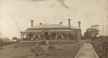 Kew Historical Society Inc
Photograph, Deepdene
Rare photograph of a significant Melbourne home.Photograph of the historically significant house, Deepdene, which was located before demolition on the southeast corner of Burke Road and Cotham Road. The photograph is on the back of a subdivision plan of the Auburn Heights Estate.deepdene -
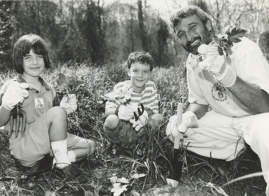 Lakes Entrance Historical Society
Photograph, B Advertiser, Weed Worriors, East Gippsland Victoria, 1990 c
Black and white photograph of Don Burke with Weed Worriors seven year old Zephyr Pavey and Maisie Dubosersky removing invasive seedlings from bushland East Gippsland Victoriaeducation, environment, land reclamation -
 St Kilda Historical Society
Photograph, St Kilda Pier and foreshore
Showing St Kilda Pier, St Kilda Yacht Club boat shed, Burke's Whisky and Burke's Stout signage.black and white photograph, unmounted copy, fair condition -
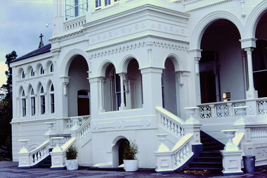 Kew Historical Society Inc
Slide - 'Burke Hall', Nolan Avenue, 1976
Colour transparency (slide) created in June 1976 during a tour by the Junior National Trust, which was led by members of Kew Historical Society. The collection of 21 slides reveals that the tour covered all parts of Kew, but focused understandably on heritage buildings and sites.Image of an historic place in Kew that can be dated to an exact time and place. The images, albeit amateurish in composition, frequently reveal aspects of important buildings and sites that have changed over time.35mm colour transparency of the front portico of Burke Hall (formerly Studley Hall, Waverley) and now Xavier Junior School in Nolan Avenue, Kew. Since its construction in the 19th century, the building has had numerous additions made by subsequent owners. The original render has been painted and sections of the original colonnades glazed in. The facade of Burke Hall faces away from Studley Park Road to take advantage of the views to the south.historic houses -- kew (vic), xavier college -- kew (vic.), burke hall -- kew (vic.), waverley -- kew (vic.), nolan avenue -- kew (vic.), studley hall -- kew (vic.) -
 Bendigo Historical Society Inc.
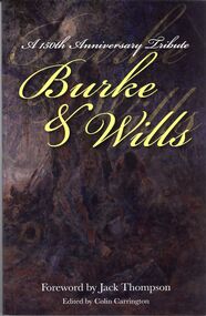
Book - BURKE & WILLS
A 150th Anniversary Tribute Burke & Wills a soft cover book of poems and stories foreword by Jack Thompson published by Bendigo Goldfields Poets Inc printed by Griffin Press illustrations by Brian.V.Nunan.books, collections, poetry -
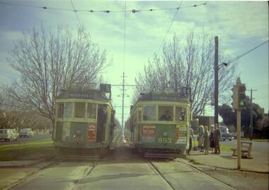 Melbourne Tram Museum
Negative, Travis Jeffrey, 10/06/1962 12:00:00 AM
Colour negative of trams 514 and 953 in Dandenong Road. Tram 514 has destination Malvern - Burke Rd and Route No 5. Photo shows tram on the left track (city-bound), although facing towards its destination (Malvern). Driver standing in door of cab and conductor standing in doorway to tram. Tram 953 has destination East Brighton via Caulfield and Route No 64. Sign on front states: "Connect with Malvern-Burke Rd tram".Paper folder that contained the negative had "NR75B" and date written as 10 Jun 62 in red ink.trams, tramways, w2 class, route 5, route 64, dandenong rd, wattle tree rd, malvern burke rd, tram 514, tram 953 -
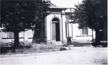
 The Beechworth Burke Museum
Photograph
This photograph depicts four men standing near a large unidentified building. This building is the entrance to a deep lead mine shaft. There is a bridge entering the building, which was used to access the elevator to the shaft. Deep lead mining involved placing large shafts into the ground which miners use to access deeper locations in order to excavate the rocks in the search for lead. Deep lead mining was highly dangerous as roofs could cave in of the soil was loose. Therefore, this particular mining considered to be highly undesirable profession as many miners did not want to work long hours nor risk their lives in the search for lead. Indigo Shire was a large area where deep lead mining took place, and thus the landscape and environment was largely impacted by these mining businesses. The Indigo Shire grew in population and wealth in the early 1850s when people came into this location in the hopes of finding gold and making a fortune. Ultimately, the accessibility and availability of gold and precious metals decreased once the gold reserves dried up and alongside this, the large population moved away. The Ovens was also heavily impacted environmentally as deep mining resulted in the change in land formation.The search for gold is ingrained into the history of Victoria and therefore, images like this one which portray an open cut sluicing site can reveal important information for society and technology for the date when the photograph was taken. This image is of important historical significance for its ability to convey information about the methods used to find gold in Indigo Shire. It also shows a location where deep mining was undertook which provides insight into the impact of deep mining on the environment at a time when it was done. This image is important for current research into the history of Indigo Shire, a region in Victoria's north-east. Therefore, this image has the capacity to be beneficial for research into society and the motivations of those living and working in this region during this period and therefore, has social significance. The Beechworth Burke Museum has additional images relating to deep lead mining and Indigo Shire which can be analysed and studied alongside images like this one.Sepia coloured retangular photo printed on gloss photographic paper.Reverse: 1997, 2510/ A02570/ Deep Lead Mining/ page 94/ 65%/ Burke Museum, Photo 44beechworth, burke museum, indigo shire, deep lead mining, mining, gold, gold mining -
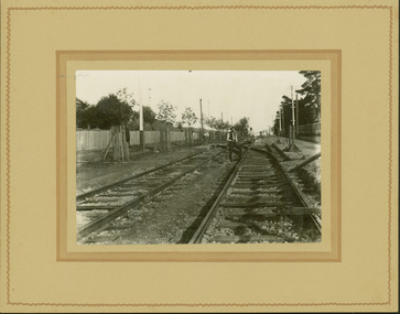 Kew Historical Society Inc
Photograph - Electric tram line construction in Cotham Road, Kew, E.J. Dower, 1913
One of a series of photographs, taken by Edgar James Dower in the second decade of the twentieth century. Born and raised in Olinda, his family later moved to Surrey Hills. He worked as an adult as a clerk in the city office of the Metropolitan Gas Company, and in his role as a 'collector', he was able to photograph scenes including the construction of tramlines and associated buildings in Kew, Hawthorn, Camberwell and Surrey Hills. Later he established a real estate agency with his brother - the E.J. Dower Real Estate Agency, Dandenong Office.The image is an historically significant record of the development of transport infrastructure which was used to connect Victorians in the first two decades of the twentieth century. This development resulted from increases in population and the consequent extension of Melbourne's suburbs. The photographs, both individually and collectively, richly detail the labour of workers and the tools and machinery used to create and extend Melbourne's tram network in the years preceding and during World War 1.Digital copy of an original mounted photograph depicting construction of a new electric tramline in Cotham Road, Kew. The photo shows a worker standing on the tracks at the then terminus.Annotated verso: "Preparing for electric trams / Cotham Road Kew / Taken from corner of Burke Road / 1913"theme --- travelling by tram, theme -- connecting victorians by transport and communications, cotham road -- kew (vic.), trams -- kew (vic.) -
 Bendigo Historical Society Inc.
Photograph - STRAUCH COLLECTION: CARL WILLIAM GOLLMICK
Copy of photograph of Carl William Gollmick at 4 years ( father of Rosemary ) with his older sister Beryl. Courtesy Miss Rosemary Gollmick, 105 Burke Rd Nth Ivanhoe East 3079.photograph, person, gollmick, bendigo-german-gollmick -
 NMIT (Northern Melbourne Institute of TAFE)
Book: The Barrier Range: a journey to Broken Hill, Ray Liversidge, 2006
Book of 220 pages of Poetry and Prose by Ray Liversidge. Full title is The Barrier Range: a journey to Broken Hill: Burke & Wills. Published by Flat Chat Press, NMIT in 2006. ISBN 1921142030 flat chat press, school publications, nmit -
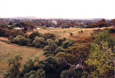 Hume City Civic Collection
Photograph, c 1980s
The photograph although recently taken shows the original settled area in Sunbury, which included Goonawarra Vineyard and Macedon Street which was once the business centre of Sunbury township before the railway was established.A coloured photograph of Sunbury Township looking west from above Jacksons Creek and Goonawarra Winery. Macedon Street can be seen in the middle distance and Mt. Holden and Burke Hill are across the skyline.sunbury township, mt. holden, burke hill, francis, james goodall, barnier, john, jacksons creek, goonawarra winery, george evans collection -
Whitehorse Historical Society Inc.
Newspaper - Article, Schwerkolt Cottage, n.d
Australian Garden Journal article by Jo-Ann C. Burke giving description of the gardens at Schwerkolt Cottage and how they were re-established in 1965 in an appropriate manner for a century old cottage garden.schwerkolt cottage, faggetter, pat -
Kew Historical Society Inc
Archive (Sub-series) - Subject File, Legacy House
Kew Historical SocietySince its foundation in 1958, members of the Kew Historical Society have been compiling and storing information about subjects relating to the history of Kew and its environs, of which this file is an example. Arranged by Secondary Values (value of records to users)Subject file containing a newspaper article reporting the removal of hedge at the corner of Burke and Cotham Roads following the sale of the property, formerly Legacy House, more recently the Christian Blind Mission International.legacy house -- kew (vic.), christian blind mission international -- kew (vic.)legacy house -- kew (vic.), christian blind mission international -- kew (vic.) -
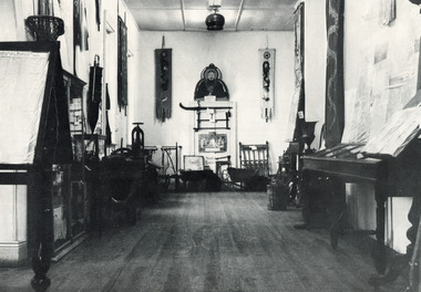 The Beechworth Burke Museum
Photograph
This black and white photograph is estimated to have been taken c1900 inside the Burke Museum. Several objects part of the museum collection at the time can be seen, with a high number of Asian influence objects visible; potentially Chinese in origin, as several Chinese villages were located around Beechworth and across Spring Creek, from the mid 1800s. The Burke Museum is part of the Precinct of Beechworth, which was established upon the discovery of gold in 1852. Originally built as the Beechworth Athenaeum in 1857, the museum was later renamed to the Robert O'Hara Burke Memorial Museum, more commonly known as the Burke Museum, in honour of the famous explorer and former Beechworth Superintendent of Police, Robert O'Hara Burke, after his death in 1861 at Coopers Creek during the famed ill-fated Burke and Wills expedition.This photograph is contextually, historically and socially significant due to its connection to both the Burke Museum and Chinese culture in and around Beechworth during the mid-1800s through to 1900s. Around 4700 people of Chinese heritage lived at the Ovens goldfield by April of 1857, representing one-quarter of the entire population at the time. The object holds strong representativeness to the history of the Burke Museum and to the objects in its collection. Its interpretive capacity could be supported and enhanced with other photographs and objects in the collection. Collectively, these records and objects could provide an insight into the museum's collection and its relationship with the origins of the objects.Black and white rectangular photograph printed on paper. Unmounted; taped to paper. beechworth, spring creek, chinese, burke museum, immigration, chinese immigration, ovens goldfield, china, museum, robert o'hara burke, burke and wills expedition, burke and wills, goldfields -
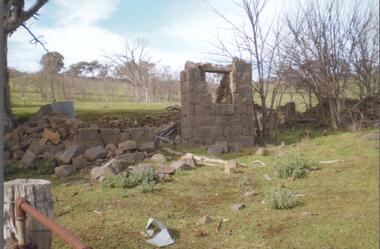 Bendigo Historical Society Inc.
Photograph - BENDIGO HISTORICAL SOCIETY COLLECTION: RUINS OF MIA MIA HOTEL
Colour photograph of bluestone ruins of former Mia Mia Hotel, Mia Mia. Part of one wall standing with window opening. Bare trees in background and on side. Burke and Wills Expedition travelled through this region and allegedly visited the Mia Mia Hotel. The Burke and Wills expedition passed through Mia Mia in 1860 on their journey across Australia from Melbourne to the Gulf of Carpentaria. They arrived on Saturday, 25 August 1860 and made Camp VI at Mia Mia.buildings, commercial, mia mia hotel -
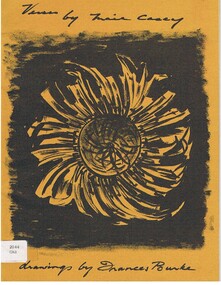 Bendigo Historical Society Inc.
Book - ALEC H CHISHOLM COLLECTION: BOOK 'VERSES BY MAIE CASEY'
Book. ALEC H CHISHOLM COLLECTION. A 19 page soft cover book of verse by Maie Casey with drawings by Frances Burke. Printed by McLaren & Co. Pty Ltd, Melbourne in 1963. (copy No. 213) Handwritten in ink on flyleaf 'Mr Alec Chisholm with best wishes from Maie Casey 8.11.63. Also the signature of Frances Burke. Catalogue sticker '2044 CAS' on front cover. Maie Casey was the wife of Lord Casey, Australian politician and Governor General.Maie Caseybooks, collections, poetry, alec h chisholm collection, poetry, maie casey, frances burke -
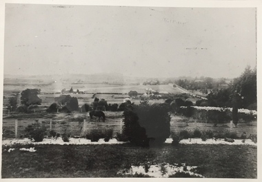 Kew Historical Society Inc
Photograph, Kew looking East to Deepdene, c.1905
Kew looking east towards Deepdene. Before 1909. The reverse of the photograph includes an analysis of the photo and the places that can be seen within it (eg Deepdene Station, first Deepdene School, Burke Road etc)farming (kew), deepdene -
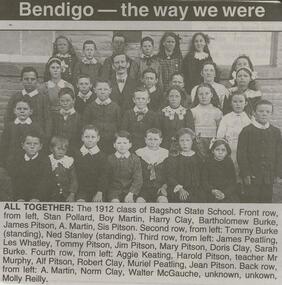 Bendigo Historical Society Inc.
Newspaper - JENNY FOLEY COLLECTION: ALL TOGETHER
Bendigo Advertiser '' The way we were'' from Monday, March 15, 2004. All together: the 1912 class of Bagshot State School. Front row, from left: Stan Pollard, Roy Martin, Harry Clay, Bartholomew Burke, James Pitson, A. Martin, Sis Pitson. Second row, from left:: Tommy Burke (standing), Ned Stanley (standing). Third row, from left: James Peatling, Les Whatley, Tommy Pitson, Mary Pitson, Doris Clay, Sarah Burke. Fourth row, from left: Aggie Keating, Harold Pitson, teacher Mr. Murphy, Alf Pitson, Robert Clay, Muriel Peatling, Jean Pitson. Back row, from left: A. Martin, Norm Clay, Walter McGauche, unknown, unknown, Molly Reilly. The clip is in a folder.newspaper, bendigo advertiser, the way we were -
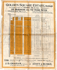 City of Moorabbin Historical Society (Operating the Box Cottage Museum)
Flyer - Golden Square Estate, Bentleigh, 1923
Land sales in the Municipality of Moorabbin increased when the train line from the City to Frankston was electrified.Example of the progress of the Municipality of MoorabbinThe train line from the city to Frankston was electrified which intensified the sale in the municipality of Moorabbin, particularly land which was in the vicinity of the railway stations.Golden Square Estate, Bentleigh - J. D. Graham, Stott & Burke - 25 business sites and 112 home sitescentre road, brewers road, jasper road, robert street, mitchell street, daley street, bendigo avenue, auction, real estate, moorabbin, bentleigh -
 The Beechworth Burke Museum
Photograph, George Peach, c. 1930
Black and White photograph taken of the Robert O'Hara Burke Memorial Museum. The museum is named in honor of explorer and former Beechworth Superintendent Robert O'Hara Burke following his death in 1861.This item is significant because it shows the historic Burke Museum in a historic context, which can be used to document the changes in the building and the surroundings which have occurred over time.Copy of a black and white landscape photograph on photographic paper.burke museum, robert o'hara burke, robert o'hara burke museum -
Whitehorse Historical Society Inc.
Document, St John's Roman Catholic Church, Mitcham, 1952 - 1972
Collection of items relating to St John's Catholic Church, Mitcham:Collection of items relating to St John's Catholic Church, Mitcham: Fifty years of work for God (Marian Monthly, vole, no 10, Nov 1910); Our parish, c1960: invitation to Dedication of St John's, 9 Nov 1952; Reminiscing : Peter O'Brien talks to Fr Coghlan (St John's Parish News, Nov 1970); St John's Parish News [Excepts 1968 - 75]; Opening of St John's Church, Mitcham (Advocate Nov 1952); The Parish of St John's (Nunawading Historical Society Newsletter, Feb-Mar, 1972); 100 years : our first church (Parish Comment, Mar 1972); The Story of St Aloysius Church, Sevenhill, by A.F. Burke.Collection of items relating to St John's Catholic Church, Mitcham: st johns catholic church, mitcham, coghlan, gerard, fr, kranewitter, aloysius, fr, lyons, douglas c, fr, st aloysius church, sevenhill, s.a. -
Whitehorse Historical Society Inc.
Article, LGB praise for Council, 1994
Leonie Burke, Local Government Board Chairperson was impressed by Nunawading's preparation and community inclusion in the impending amalgamation decision.Leonie Burke, Local Government Board Chairperson was impressed by Nunawading's preparation and community inclusion in the impending amalgamation decision. Cr Abbott stated Box Hill's resident survey was incorrect regarding rates after a merger.Leonie Burke, Local Government Board Chairperson was impressed by Nunawading's preparation and community inclusion in the impending amalgamation decision. local government, city of box hill, city of nunawading, city of whitehorse, amalgamations, local government finance -
 8th/13th Victorian Mounted Rifles Regimental Collection
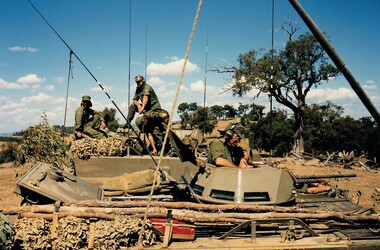
Photograph
In the period 5-20 March 1988, ‘A’ Squadron 8th/13th Victorian Mounted Rifles participated in an exercise conducted at Puckapunyal by 4th Infantry Brigade (Reserve) codenamed ‘Fiery Cauldron’. Other units participating included 5th/6th Battalion and 8th/7th Battalion Royal Victorian Regiment, 4th/19th Prince of Wales’s Light Horse Regiment and 1st Armoured Regiment. The training focussed on armoured/infantry cooperation, in particular the use of armoured personnel carriers. Colour photograph of two M113 Armoured Personnel Carriers at Puckapunyal during Exercise " Fiery Cauldron " 5 - 20 March 1988. Crewmen identified : Sergeant Burke standing on carrier; Captain Colin Carrington in turret of carrier. -
Port Melbourne Historical & Preservation Society
Container - Bottle, Burke's Pale Ale, excavated from cesspit behind All England Eleven Hotel, Port Melbourne, 1850s
When house in Rouse Street was demolished in November 1997, Peter LIBBIS obtained this from the bottle diggers who emptied the former cesspit behind All England Eleven Hotel.Beer bottle c1850-60s Burke's Pale Ale. Dug from cesspit behind All England Eleven Hotel, in Little Princes lane (ref photos of cesspit excavation 895)/ Dark green, fragments of label.business and traders - hotels, all england eleven hotel