Showing 406 items
matching bushfires australia
-
 Marysville & District Historical Society
Photograph (Item) - Black and white photograph, Unknown
A digital copy of a black and white photograph of the swimming pool at Marysville House. Marysville House was built in the late 1920s by Arthur Dickinson.A digital copy of a black and white photograph of the swimming pool at Marysville House. Marysville House was built in the late 1920s by Arthur Dickinson.marysville, victoria, australia, marysville house, arthur james dickinson, grace dickinson, arnold spooner, eileen marie spooner, eileen marie dickinson, grace sweetland, eric dowdle, elsie may denton, elsie may dickinson, peter dickinson, linda dickinson, 2009 black saturday bushfires, photograph, swimming pool -
 Marysville & District Historical Society
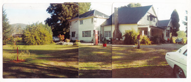
Photograph (Item) - Colour panoramic photograph, Unknown
A digital copy of a colour panoramic photograph of Marysville House. Marysville House was built in the late 1920s by Arthur Dickinson.A digital copy of a colour panoramic photograph of Marysville House. Marysville House was built in the late 1920s by Arthur Dickinson.marysville, victoria, australia, marysville house, arthur james dickinson, grace dickinson, arnold spooner, eileen marie spooner, eileen marie dickinson, grace sweetland, eric dowdle, elsie may denton, elsie may dickinson, peter dickinson, linda dickinson, 2009 black saturday bushfires, photograph -
 Eltham District Historical Society Inc
Photograph - Digital Photograph, Alan King, Wycliffe Centre, Graham Road, Kangaroo Ground, 2008
Wycliffe translates the Bible for people around the world. Published: Nillumbik Now and Then / Marguerite Marshall 2008; photographs Alan King with Marguerite Marshall.; p171 The peace and beauty of Australia’s Wycliffe Centre reflects what it aims to bring to thousands of people around the world. Kangaroos calmly feed, accompanied by bird song, near the mud-brick buildings set amongst Kangaroo Ground’s rolling hills. On 11 hectares off Graham Road, the centre aims to transform people’s lives by giving groups around the world, with no written language, help with literacy and Bible translation into their own tongue. Associate Director, Harley Beck, says reading the Bible (probably history’s most influential collection of books), in one’s own language, provides a strong moral basis, helping people withstand exploitation and escape poverty. One of Wycliffe’s field partners, SIL (formerly Summer Institute of Linguistics) Papua New Guinea, has won two UNESCO awards, and SIL branches in many other countries have won international and national awards. The translators are modern heroes. They undertake hardships, forsaking for years, sometimes decades, a salary and the soft western lifestyle, to face loneliness and primitive conditions that most of us would not even contemplate. No staff is paid a salary. An example is the first Australian Director and former International President, David Cummings, who for 50 years has depended on donations from supporters and churches. Students of all ages at the EQUIP Training School on the site come from all walks of life. They train in linguistics and learn how to communicate in a way that is sensitive to other cultures. Spiritual resilience is encouraged, enabling people to persist until the job in the field is done, which takes on average ten to 15 years. Courses range from a few weeks to a year. The Wycliffe concept was born in the 1920s when American missionary, Cameron Townsend, found a Spanish Bible was inadequate to evangelise the Cakchiquel people of Guatemala. When a Cakchiquel man challenged: ‘If your God is so great, why doesn’t he speak my language?’ Townsend decided to translate the Bible into all languages! He founded a linguistics training school in 1934, naming it after 14th century theologian John Wycliffe, the first to translate the Bible into English. The first Wycliffe Bible was completed in 1951 in the Mexican San Miguel Mixtec language. In May 2007 after 30 years of work, Wycliffe Australia, with other organisations, completed the first Bible for indigenous people in the Kriol* language, for about 30,000 people in northern Australia. Wycliffe Australia began in 1954 in the Keswick Bookshop basement, Collins Street, Melbourne. As the organisation grew, its quarters became so cramped that Director Cummings at times interviewed potential recruits in his car! The development of the Kangaroo Ground property is a story of faith and generosity. In 1967 Cummings proposed moving to a larger property despite having no funds. Within a month Wycliffe received a $20,000 donation and a gift of land towards a national centre. An earlier owner of the Kangaroo Ground property, Mrs Elsie Graham, would have been delighted, as she had wanted her land to be used for ‘God’s service’. Mud-brick architect and Christian, Alistair Knox, offered to design the centre at no charge. Despite a drought, straw was donated to make bricks. Many volunteers helped with the building, including church youth groups who made mud-bricks. Volunteers planted thousands of native plants, watered by recycled water from the site’s dam. Building began in 1968 and in 1983 the South Pacific SIL School (now EQUIP Training) followed. Wycliffe, the world’s largest linguistic organisation, and other organisations, have translated the Scriptures into more than 2000 languages. But another 2000 languages still lack any portion of the Bible. However translations are now completed more quickly, because of new computer programs and as education spreads, more speakers of the local language can assist. Despite the growth of secularisation, Beck says support for Wycliffe Australia, which has offices in all states and the ACT, is stronger than ever. * Kriol is a Pidgin language, which has become a speech community’s prime language.This collection of almost 130 photos about places and people within the Shire of Nillumbik, an urban and rural municipality in Melbourne's north, contributes to an understanding of the history of the Shire. Published in 2008 immediately prior to the Black Saturday bushfires of February 7, 2009, it documents sites that were impacted, and in some cases destroyed by the fires. It includes photographs taken especially for the publication, creating a unique time capsule representing the Shire in the early 21st century. It remains the most recent comprehenesive publication devoted to the Shire's history connecting local residents to the past. nillumbik now and then (marshall-king) collection, graham road, kangaroo ground, wycliffe centre -
 Eltham District Historical Society Inc
Photograph - Digital Photograph, Alan King, Blue Lake, Plenty Gorge Park, 2008
A quarry was transformed into the Blue Lake. Published: Nillumbik Now and Then / Marguerite Marshall 2008; photographs Alan King with Marguerite Marshall.; p179 The dramatic steep-sided Plenty Gorge lies along the divide of two geological areas, and separates the Nillumbik Shire and the City of Whittlesea. On the Nillumbik side are undulating hills and sedimentary rock, and in Whittlesea, lies a basalt plain formed by volcanic action up to two million years ago. This provides the Plenty Gorge Park with diverse vegetation and habitats, making it one of Greater Melbourne’s most important refuges for threatened and significant species. The park, established in 1986, consists of around 1350 hectares, and extends 11 kilometres along the Plenty River, from Greensborough to Mernda. It provides a wildlife corridor for around 500 native plant and 280 animal species. The area’s plentiful food and water attracted the Wurundjeri Aboriginal people and then European settlers. By 1837 squatters had claimed large runs of land for their sheep and cattle. The Plenty Valley was among the first in the Port Phillip District to be settled - mainly in the less heavily timbered west - and was proclaimed a settled district in 1841.But by the late 1880s, the settlers’ extensive land clearing for animal grazing, then agriculture, depleted the Wurundjeri’s traditional food sources, which helped to drive them away. Many Wurundjeri artefacts remain (now government protected), and so far 57 sites have been identified in the park, including scarred trees, burial areas and stone artefacts. Pioneer life could be very hard because of isolation, flooding, bushfires and bushrangers. Following the Black Thursday bushfires of 1851, basalt was quarried to build more fire-resistant homes. Gold discoveries in the early 1850s swelled the population, particularly around Smugglers Gully; but food production made more of an impact. In the late 1850s wheat production supplanted grazing. In the 1860s the government made small holdings available to poorer settlers. These had the greatest effect on the district, particularly in Doreen and Yarrambat, where orchards were established from the 1880s to 1914. Links with a prominent early family are the remains of Stuchbery Farm, by the river’s edge bounded by Smugglers Gully to the north and La Trobe Road, Yarrambat, to the east. The Stuchberys moved to the valley in 1890, and the family still lives in the area. In 1890, Alfred and Ada first lived in a tent where four children were born, then Alfred built the house and outbuildings around 1896. They planted an orchard, then a market garden, and developed a dairy. The family belonged to the local Methodist and tennis communities. Their grandson Walter, opened the Flying Scotsman Model Railway Museum in Yarrambat, which his widow, Vi, continues to run. Wal was also the Yarrambat CFA Captain for 22 years until 1987. Walter sold 24 hectares in 1976 for development - now Vista Court - and in 1990, the remaining 22.6 hectares for the park. Remaining are an early stone dairy and remnants of a stone barn, a pig sty and a well. Until it was destroyed by fire in 2003, a slab hut stood on the Happy Hollow Farm site, at the southern end of the park. The hut is thought to have been built in the Depression around 1893. This was a rare and late example of a slab hut with a domestic orchard close to Melbourne. Emmet Watmough and his family first occupied the hut, followed by a succession of families, until the Bell family bought it around 1948. There they led a subsistence lifestyle for 50 years, despite encroaching Melbourne suburbia. The Yellow Gum Recreation Area includes the Blue Lake, coloured turquoise at certain times of the year. Following the 1957 bushfires, this area was quarried by Reid Quarries Pty Ltd for Melbourne’s first skyscrapers, then by Boral Australia. However in the early 1970s water began seeping into the quarry forming the Blue Lake and the quarry was closed. The State Government bought the site in 1997 and opened it as a park in 1999.This collection of almost 130 photos about places and people within the Shire of Nillumbik, an urban and rural municipality in Melbourne's north, contributes to an understanding of the history of the Shire. Published in 2008 immediately prior to the Black Saturday bushfires of February 7, 2009, it documents sites that were impacted, and in some cases destroyed by the fires. It includes photographs taken especially for the publication, creating a unique time capsule representing the Shire in the early 21st century. It remains the most recent comprehenesive publication devoted to the Shire's history connecting local residents to the past. nillumbik now and then (marshall-king) collection, blue lake, plenty gorge park -
 Eltham District Historical Society Inc
Photograph - Digital Photograph, Marguerite Marshall, Stuchbery Farm dairy, 14 March 2008
Stuchbery Farm was situated on the Plenty River bounded by Smugglers Gully to the north and La trobe Road, Yarrambat, to the east. Alan and Ada Stutchbery moved to the valley in 1890, first living in a tent where four children were born. Alfred built a home and outbuildings around 1896. They planted an orchard, then a market garden and developed a dairy. Published: Nillumbik Now and Then / Marguerite Marshall 2008; photographs Alan King with Marguerite Marshall.; p179 The dramatic steep-sided Plenty Gorge lies along the divide of two geological areas, and separates the Nillumbik Shire and the City of Whittlesea. On the Nillumbik side are undulating hills and sedimentary rock, and in Whittlesea, lies a basalt plain formed by volcanic action up to two million years ago. This provides the Plenty Gorge Park with diverse vegetation and habitats, making it one of Greater Melbourne’s most important refuges for threatened and significant species. The park, established in 1986, consists of around 1350 hectares, and extends 11 kilometres along the Plenty River, from Greensborough to Mernda. It provides a wildlife corridor for around 500 native plant and 280 animal species. The area’s plentiful food and water attracted the Wurundjeri Aboriginal people and then European settlers. By 1837 squatters had claimed large runs of land for their sheep and cattle. The Plenty Valley was among the first in the Port Phillip District to be settled - mainly in the less heavily timbered west - and was proclaimed a settled district in 1841. But by the late 1880s, the settlers’ extensive land clearing for animal grazing, then agriculture, depleted the Wurundjeri’s traditional food sources, which helped to drive them away. Many Wurundjeri artefacts remain (now government protected), and so far 57 sites have been identified in the park, including scarred trees, burial areas and stone artefacts. Pioneer life could be very hard because of isolation, flooding, bushfires and bushrangers. Following the Black Thursday bushfires of 1851, basalt was quarried to build more fire-resistant homes. Gold discoveries in the early 1850s swelled the population, particularly around Smugglers Gully; but food production made more of an impact. In the late 1850s wheat production supplanted grazing. In the 1860s the government made small holdings available to poorer settlers. These had the greatest effect on the district, particularly in Doreen and Yarrambat, where orchards were established from the 1880s to 1914. Links with a prominent early family are the remains of Stuchbery Farm, by the river’s edge bounded by Smugglers Gully to the north and La Trobe Road, Yarrambat, to the east. The Stuchberys moved to the valley in 1890, and the family still lives in the area. In 1890, Alfred and Ada first lived in a tent where four children were born, then Alfred built the house and outbuildings around 1896. They planted an orchard, then a market garden, and developed a dairy. The family belonged to the local Methodist and tennis communities. Their grandson Walter, opened the Flying Scotsman Model Railway Museum in Yarrambat, which his widow, Vi, continues to run. Wal was also the Yarrambat CFA Captain for 22 years until 1987. Walter sold 24 hectares in 1976 for development - now Vista Court - and in 1990, the remaining 22.6 hectares for the park. Remaining are an early stone dairy and remnants of a stone barn, a pig sty and a well. Until it was destroyed by fire in 2003, a slab hut stood on the Happy Hollow Farm site, at the southern end of the park. The hut is thought to have been built in the Depression around 1893. This was a rare and late example of a slab hut with a domestic orchard close to Melbourne. Emmet Watmough and his family first occupied the hut, followed by a succession of families, until the Bell family bought it around 1948. There they led a subsistence lifestyle for 50 years, despite encroaching Melbourne suburbia. The Yellow Gum Recreation Area includes the Blue Lake, coloured turquoise at certain times of the year. Following the 1957 bushfires, this area was quarried by Reid Quarries Pty Ltd for Melbourne’s first skyscrapers, then by Boral Australia. However in the early 1970s water began seeping into the quarry forming the Blue Lake and the quarry was closed. The State Government bought the site in 1997 and opened it as a park in 1999.This collection of almost 130 photos about places and people within the Shire of Nillumbik, an urban and rural municipality in Melbourne's north, contributes to an understanding of the history of the Shire. Published in 2008 immediately prior to the Black Saturday bushfires of February 7, 2009, it documents sites that were impacted, and in some cases destroyed by the fires. It includes photographs taken especially for the publication, creating a unique time capsule representing the Shire in the early 21st century. It remains the most recent comprehenesive publication devoted to the Shire's history connecting local residents to the past. nillumbik now and then (marshall-king) collection, ada stuchbery, alan stuchbery, dairy, stuchbery farm, farm buildings, yarrambat, plenty gorge park -
 Falls Creek Historical Society
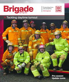
Magazine - Brigade Magazine Spring 2016
Brigade Magazine is issued to members of the Victorian CFA. The Spring edition of 2016 includes an article to acknowledge 21 years of service by the Falls Creek CFA. The article was written by Joy Nowakowski on behalf of the Falls Creek CFA with information provided by the Falls Creek Historical Society. Falls Creek Fire Brigade protects Falls Creek Village from fires throughout the year and supports other brigades to fight bushfires nearby and further away. In 2016 the brigade had 23 year-round volunteers. At a celebratory function at Falls Creek in June 2016, alpine pumper and brigade snowmobiles were on display. Falls Creek’s alpine pumper was the first of its kind in Australia. It had a pumping capacity of 4,000 litres a minute and its tracks enabled it to access areas of the village and ski fields. Until 2016 Falls Creek Village has been threatened by two major fires, the worst being in 2003 when CFA crews saved the village and the adjoining ski field infrastructure right at the boundaries. Snow making equipment was used to create a water/fog barrier that helped stop the fires from taking the village. The team that saved the village was considered heroic Support for fighting fires at Falls Creek dates back to 1956 but this support came from Mount Beauty, 30 kilometres down the mountain. Falls Creek locals were concerned by this, so used six available hydrants and a canvas hose to fight any fires on the mountain. In 1964 the SECV gave the village a trailer which could be used with both wheels and skis for summer and winter operations. But this trailer only lasted two years. In the early 1970s, the village was given a 2,000-gallon Ford Blitz 4WD truck, and additional equipment was quickly acquired by the village including a new locally-constructed trailer with a pumper unit. In the 1990s, a change in land status meant the Falls Creek area became the responsibility of CFA. This status was formalised in 1995 by a public meeting that formed Falls Creek Fire Brigade.This magazine is significant because it contains an article celebrating 21 years of Falls Creek CFA.A publication for CFA members which includes stories about recent incidents, brigades, training, events, community safety, health and safety and general CFA news. falls creek cfa, alpine firefighting, falls creek cfa 21 years -
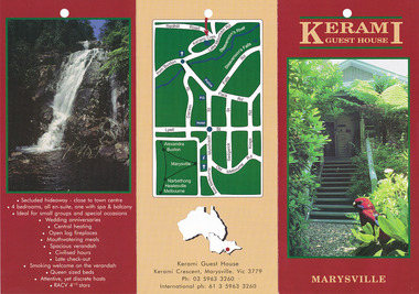
 Marysville & District Historical Society
Newspaper (Item) - Newspaper advertisement, KERAMI, Unknown
A newspaper advertisement regarding Kerami Guest House in Marysville.A newspaper advertisement regarding Kerami Guest House in Marysville.marysville, victoria, australia, kerami guest house, accommodation, corn cakes recipe, 2009 black saturday bushfires -
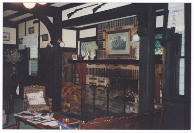 Marysville & District Historical Society
Photograph (Item) - Colour photograph, 1996
A colour photograph of a room in the interior of Kerami Guest House taken in 1996. Kerami Guest House was located in Marysville.A colour photograph of a room in the interior of Kerami Guest House taken in 1996. Kerami Guest House was located in Marysville.1996marysville, victoria, australia, kerami guest house, accommodation, 2009 black saturday bushfires, photograph -
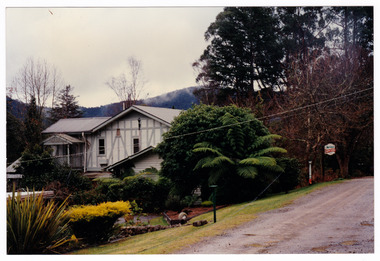 Marysville & District Historical Society
Photograph (Item) - Colour photograph, 1996
A colour photograph of Kerami Guest House taken in 1996. Kerami Guest House was located in Marysville.A colour photograph of Kerami Guest House taken in 1996. Kerami Guest House was located in Marysville.1996marysville, victoria, australia, kerami guest house, accommodation, 2009 black saturday bushfires, photograph -
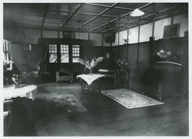 Marysville & District Historical Society
Photograph (Item) - Black and white photograph, Unknown
A black and white photograph of a room in the interior of Kerami Guest House. Kerami Guest House was located in Marysville.A black and white photograph of a room in the interior of Kerami Guest House. Kerami Guest House was located in Marysville.marysville, victoria, australia, kerami guest house, accommodation, 2009 black saturday bushfires, photograph -
 Marysville & District Historical Society
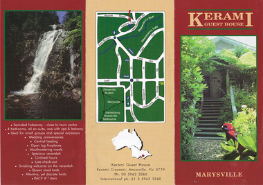
Ephemera (Item) - Information brochure, KERAMI GUEST HOUSE, Unknown
An information brochure regarding Kerami Guest House in Marysville.An information brochure regarding Kerami Guest House in Marysville.marysville, victoria, australia, kerami guest house, accommodation, 2009 black saturday bushfires, information brochure -
 Marysville & District Historical Society
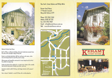
Ephemera (Item) - Information brochure, KERAMI GUEST HOUSE, Unknown
An information brochure regarding Kerami Guest House in Marysville.An information brochure regarding Kerami Guest House in Marysville.marysville, victoria, australia, kerami guest house, accommodation, 2009 black saturday bushfires, information brochure -
 Marysville & District Historical Society
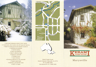
Ephemera (Item) - Information brochure, KERAMI GUEST HOUSE, Unknown
An information brochure regarding Kerami Guest House in Marysville.An information brochure regarding Kerami Guest House in Marysville.marysville, victoria, australia, kerami guest house, accommodation, 2009 black saturday bushfires, information brochure -
 Marysville & District Historical Society
Flyer (Item) - Information flyer, Unknown
An information flyer regarding Kerami Manor in Marysville.An information flyer regarding Kerami Manor in Marysville.marysville, victoria, australia, kerami guest house, accommodation, 2009 black saturday bushfires, information flyer -
 Marysville & District Historical Society
Newspaper (Item) - Newspaper article, Anne Richey, Marysville's Kerami Manor re-opens, 09-11-2016
... in the 2009 Black Saturday bushfires. A newspaper article regarding ...A newspaper article regarding the re-opening of Kerami Manor in Marysville after the original guest house was destroyed in the 2009 Black Saturday bushfires.A newspaper article regarding the re-opening of Kerami Manor in Marysville after the original guest house was destroyed in the 2009 Black Saturday bushfires.marysville, victoria, australia, kerami guest house, accommodation, 2009 black saturday bushfires, newspaper article, the alexandra & eildon standard -
 Marysville & District Historical Society
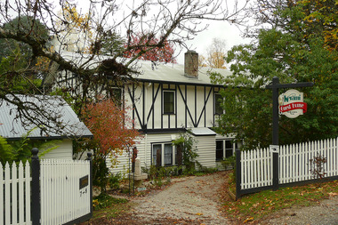
Photograph (Item) - Colour photograph, Unknown
A digital copy of a colour photograph of Kerami Guest House in Marysville.A digital copy of a colour photograph of Kerami Guest House in Marysville.marysville, victoria, australia, kerami guest house, accommodation, 2009 black saturday bushfires, photograph -
 Marysville & District Historical Society
Photograph (Item) - Colour photograph, Unknown
A digital copy of a colour photograph of Kerami Guest House in Marysville.A digital copy of a colour photograph of Kerami Guest House in Marysville.marysville, victoria, australia, kerami guest house, accommodation, 2009 black saturday bushfires, photograph -
 Department of Energy, Environment and Climate Action
Rakehoe (McLeod Tool)
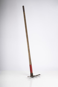
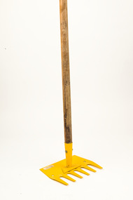
Bushfire perimeter rather than bushfire area is the main control problem for firefighters on the ground. A conundrum rapidly compounded by spot fires. A small 5 ha fire can be nearly 1 km around the perimeter. That's a long way to build a control line by hand in rough bush. Dry firefighting techniques by hand were mostly confined to “knocking down” or “beating out” the flames, as well as "digging out". Digging or raking a “mineral earth” trail down to bare dirt proved most effective in forest fuels which, unlike grass, tend to retain heat and smoulder. Early tools were whatever happened to be close at hand. They were simple and primitive and included shovels, slashers, axes, hoes, beaters and rakes. A cut branch to beat the flames was often the only thing available. Farming and logging tools, developed over centuries of manual labour, and readily available at local hardware stores came into use, but little thought was given to size, weight, and balance. For years foresters experimented with combination tools. In about 1952 fire beaters and other implements were being replaced with Rakuts. However, its believed the now common Rakehoe is an Australian variation of the American McLeod Tool which was developed in 1905 by forest ranger Malcolm McLeod of the Sierra National Forest. The late Athol Hodgson advised that predecessors, Reg Torbet who had been the Chief Fire Officer for the Forests Commission from 1948-1956, along with his QLD counterpart Clive Price, went in late 1951 as Australian delegates on a 10 week fire study tour of Nth America organised by the United Nations. They came back with a couple of McLeod tools from Canada. Cam MacLeod (different spelling) had been the Head of Fire Research for the Canadian Forest Service at the time and had supplied them. The tools were ideal for deciduous forests in the eastern provinces and Clive arranged to have them manufactured in QLD. The Rakho, as it was then spelled, was first issued to FCV crews 65 years ago in 1955-56. The American Pulaski had been trialled, but never found favour with Australian firefighters.Rakhoeforests commission victoria (fcv), hand tools, forest harvesting, bushfire -
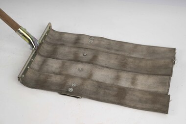 Department of Energy, Environment and Climate Action
Fire beater (canvas)
Bushfire perimeter rather than bushfire area is the main control problem for firefighters on the ground. A conundrum rapidly compounded by spot fires. A small 5 ha fire can be nearly 1 km around the perimeter. That's a long way to build a control line by hand in rough bush. Dry firefighting techniques by hand were mostly confined to “knocking down” or “beating out” the flames, as well as "digging out". Digging or raking a “mineral earth” trail down to bare dirt proved most effective in forest fuels which, unlike grass, tend to retain heat and smoulder. Early tools were whatever happened to be close at hand. They were simple and primitive and included shovels, slashers, axes, hoes, beaters and rakes. A cut branch to beat the flames was often the only thing available. Farming and logging tools, developed over centuries of manual labour, and readily available at local hardware stores came into use, but little thought was given to size, weight, and balance. For years foresters experimented with combination tools. In about 1952 fire beaters and other implements were being replaced with Rakuts. However, its believed the now common Rakehoe is an Australian variation of the American McLeod Tool which was developed in 1905 by forest ranger Malcolm McLeod of the Sierra National Forest. The late Athol Hodgson advised that predecessors, Reg Torbet who had been the Chief Fire Officer for the Forests Commission from 1948-1956, along with his QLD counterpart Clive Price, went in late 1951 as Australian delegates on a 10 week fire study tour of Nth America organised by the United Nations. They came back with a couple of McLeod tools from Canada. Cam MacLeod (different spelling) had been the Head of Fire Research for the Canadian Forest Service at the time and had supplied them. The tools were ideal for deciduous forests in the eastern provinces and Clive arranged to have them manufactured in QLD. The Rakho, as it was then spelled, was first issued to FCV crews 65 years ago in 1955-56. The American Pulaski had been trialled, but never found favour with Australian firefighters.Fire Beater (canvas) 1930s designforests commission victoria (fcv), hand tools, forest harvesting, bushfire -
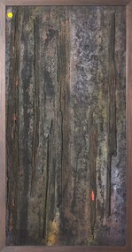 Merri-bek City Council
Mixed media - Callistemon charcoal and ink on marine ply, Brian McKinnon, Bush Fire I “Redgum Sleeper”, 2019
... responded to the Australian bushfires of 2019 in relation to his ... -
 Marysville & District Historical Society
Magazine (item) - Magazine article, Emily Friedel, Saladin's Story, 2021
A magazine article on the history of Saladin Lodge in Narbethong that appeared in the Murrindindi Guide of Autumn 2021.A magazine article on the history of Saladin Lodge in Narbethong that appeared in the Murrindindi Guide of Autumn 2021.narbethong, victoria, australia, saladin lodge, accommodation, events, conferences, catering, cafe, produce store, b&b accommodation, information flyer, kim rycroft, john robert crooke, aspendale racecourse, saladin, 1872 australian cup, dr peter crooke, sally crooke, dean crooke, 2009 black saturday bushfires -
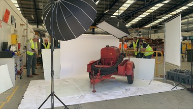 Department of Energy, Environment and Climate Action
Altona Collection Photography and Cataloguing - November 2024
In November 2024, a small group of cheerful volunteers from the Forests Commission Retired Personnel Association (FCRPA) toiled over nine days to dust-off, photograph and record nearly 300 artifacts in DEECA's Altona Museum. It followed a similar project at the FCRPA's Beechworth Museum in February 2024. The Altona project was generously supported by DEECA / FFMVic to engage professional photographer Mark Jesser from Wodonga whose boundless energy and good humour helped to create these amazing images. Special thanks go to the FFMVic Chief Fire Officer, Chris Hardman, as well as Andrew Stanios and Kat Jensen for making it happen. FFMVic crews and the ever-patient staff from Altona took a strong interest and also helped to shift some of the heavy items like pumps and the Bedford tanker which was very welcome. The Forests Commission and its successors continuously encouraged bushfire research and innovation. In 1946 a large parcel of industrial land was purchased at North Altona as a fire cache and workshop. The Altona workshop became a hotbed of new technological thingumajigs… a marvellous blend of Aladdin’s Cave of Wonders coupled with Wallace and Gromit’s madcap contraptions… an exhilarating place where lots of gizmos were invented and tested… mostly with astounding results... but nearly always with some head-scratching frustrations… and thankfully not too much explosive mayhem. In fact, a lot of Australia’s pioneering equipment development was led by staff from Altona, often in collaboration with other State forestry and fire authorities. The CSIRO also contributed significantly. The US Forest Service, the US Bureau of Land Management and US State agencies such as the California Department of Forestry and Fire (CalFire) as well as the Canadian Forest Service faced similar challenges and proved strong and willing partners in sharing knowledge, ideas, equipment and expertise over many decades. The collection at Altona started in the 1970s by fire equipment wizard Barry (Rocky) Marsden. As obsolete equipment was returned to the Fire Protection Workshop for auction, Rocky began the process of selecting some which would be interesting to retain and display. The items at Altona represent just a small sample of the amazing story of Victoria's forestry and bushfire heritage. The largest item was undoubtedly the Bedford tanker which took two days and nearly 1000 photos which were later stitched together with photoshop. The oldest item is probably the Ericsson wall telephone from 1904. There are also many unique items, but the CSIRO incendiary machine and ping-pong incendiary machine developed at Altona probably had the most significant impact on fire management in Australia. There are plenty of gaps in the collection, but some items are in regional DEECA offices. It’s hoped to merge the FCRPA's Beechworth collection to Altona one day and rename the site to honour Rocky Marsden. There may be some additions to the Altona museum over time, but space is limited. The museum is available to visit by appointment. Peter McHugh - January 2025 forests commission victoria (fcv) -
 Department of Energy, Environment and Climate Action
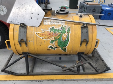
Aerial Drip Torch (ADT) or "Dragon"
The Aerial Drip Torch (ADT) was an idea conceived in Canada in the 1970s by John Muraro It was developed in 1982 by the New Zealand Forest Service to become the Ashley Aphid Helitorch. Forestry Tasmania acquired one of the machines and modified it in February 1987. Also known as a dragon helitorch it consisted of a large 135-litre tank containing jellied petrol, a displacement pump, propane ignition system, burner nozzle and fire extinguisher system. It was first trialled in Victoria at Swifts Creek in 1991 and the Aerial Drip Torch (ADT) has now become standard practice.Two Aerial Drip Torches (ADTs) were built in the 1990s by the Fire Equipment Development Centre at North Altona, They were developed in conjunction with the Department of Conservation and Land Management in Western Australia. The first was trialled during the 1991/92 autumn burning season. The machine proved to be successful and a second machine was introduced in 1998 to assist with burning operations across the State. The ADTs were commonly used for regeneration burning (controlled burning of logging slash). The first ADT introduced in 1992 had a dry weight of 160kg and a capacity of 130 litres, providing about an hour of operation. Following initial use, systematic modifications were adapted including improved ignition of gel at the drop tube, installation of an air bleed valve at the pump to assist pump priming and improved mounting brackets for the CO2 bottles and propane canister attached to the machine. The second, and lightweight ADT, introduced in 1998 had a dry weight of 68kg and a capacity of 200 litres due to a smaller lightweight frame and plastic (Polyfin) tank. In operation the ADT is suspended below a helicopter via four strops attached to the vessel and a cable to the helicopter cargo hook. Gelled fuel is dispensed via a drop tube which is attached to the pump outlet of the machine, and ignited via a gas torch. Safety features built into the first ADT were: a brass melting plug designed to be activated at 200 C bursting disc designed to burst at170 Kpa should the vessel over pressurise. a pressure relief valve set to 35 Kpa ( vessel operated between 16 &34 Kpa) a low pressure sensor designed to shut down the machine should the vessel pressure drop below 15Kpa. the vessel is filled with CO2 above the gelled fuel to eliminate ignition with in the vessel. CO2 is used to expel any residue of ignited gel from the drop tube to prevent ignition when flying outside the boundaries of the burning area. See FIRE EQUIPMENT NOTE - 46 [ https://drive.google.com/file/d/1CKtcH-3rUlrtbE9dkNP27PYT2-raVVhF/view ]forests commission victoria (fcv), bushfire, bushfire aviation, planned burning -
 Department of Energy, Environment and Climate Action
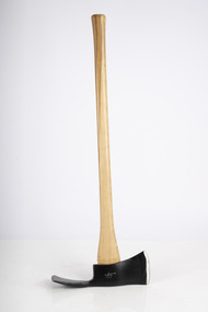
Pulaski
Bushfire perimeter rather than bushfire area is the main control problem for firefighters on the ground. A conundrum rapidly compounded by spot fires. A small 5 ha fire can be nearly 1 km around the perimeter. That's a long way to build a control line by hand in rough bush. Dry firefighting techniques by hand were mostly confined to “knocking down” or “beating out” the flames, as well as "digging out". Digging or raking a “mineral earth” trail down to bare dirt proved most effective in forest fuels which, unlike grass, tend to retain heat and smoulder. Early tools were whatever happened to be close at hand. They were simple and primitive and included shovels, slashers, axes, hoes, beaters and rakes. A cut branch to beat the flames was often the only thing available. Farming and logging tools, developed over centuries of manual labour, and readily available at local hardware stores came into use, but little thought was given to size, weight, and balance. For years foresters experimented with combination tools. In about 1952 fire beaters and other implements were being replaced with Rakuts. However, its believed the now common Rakehoe is an Australian variation of the American McLeod Tool which was developed in 1905 by forest ranger Malcolm McLeod of the Sierra National Forest. The late Athol Hodgson advised that predecessors, Reg Torbet who had been the Chief Fire Officer for the Forests Commission from 1948-1956, along with his QLD counterpart Clive Price, went in late 1951 as Australian delegates on a 10 week fire study tour of Nth America organised by the United Nations. They came back with a couple of McLeod tools from Canada. Cam MacLeod (different spelling) had been the Head of Fire Research for the Canadian Forest Service at the time and had supplied them. The tools were ideal for deciduous forests in the eastern provinces and Clive arranged to have them manufactured in QLD. The Rakho, as it was then spelled, was first issued to FCV crews 65 years ago in 1955-56. The American Pulaski had been trialled, but never found favour with Australian firefighters.Pulaski Fire Tool Combines an axe and a grubbing hoe. Digging end and cutting end with short wooden handleforests commission victoria (fcv), hand tools, forest harvesting, bushfire -
 Forests Commission Retired Personnel Association (FCRPA)
Rakehoe, McLeod Tool (American)
Bushfire perimeter rather than bushfire area is the main control problem for firefighters on the ground. A conundrum rapidly compounded by spot fires. A small 5 ha fire can be nearly 1 km around the perimeter. That's a long way to build a control line by hand in rough bush. Dry firefighting techniques by hand were mostly confined to “knocking down” or “beating out” the flames, as well as "digging out". Digging or raking a “mineral earth” trail down to bare dirt proved most effective in forest fuels which, unlike grass, tend to retain heat and smoulder. Early tools were whatever happened to be close at hand. They were simple and primitive and included shovels, slashers, axes, hoes, beaters and rakes. A cut branch to beat the flames was often the only thing available. Farming and logging tools, developed over centuries of manual labour, and readily available at local hardware stores came into use, but little thought was given to size, weight, and balance. For years foresters experimented with combination tools. In about 1952 fire beaters and other implements were being replaced with Rakuts. However, its believed the now common Rakehoe is an Australian variation of the American McLeod Tool which was developed in 1905 by forest ranger Malcolm McLeod of the Sierra National Forest. The late Athol Hodgson advised that predecessors, Reg Torbet who had been the Chief Fire Officer for the Forests Commission from 1948-1956, along with his QLD counterpart Clive Price, went in late 1951 as Australian delegates on a 10 week fire study tour of Nth America organised by the United Nations. They came back with a couple of McLeod tools from Canada. Cam MacLeod (different spelling) had been the Head of Fire Research for the Canadian Forest Service at the time and had supplied them. The tools were ideal for deciduous forests in the eastern provinces and Clive arranged to have them manufactured in QLD. The Rakho, as it was then spelled, was first issued to FCV crews 65 years ago in 1955-56. The American Pulaski had been trialled, but never found favour with Australian firefighters.First used in 1955Rakehoe Combination of a heavy-duty six-toothed (each 9cm long) rake with a large, sturdy (25cm) hoe.bushfire, forests commission victoria (fcv) -
 Marysville & District Historical Society
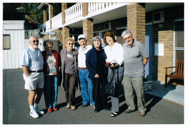
Photograph (item) - Colour photograph, 2008
A colour photograph of the Life Activities Club Croydon outside the Tower Motel in Marysville. The photograph was taken in 2008. The Tower Motel was one of the few buildings in Marysville to survive the 2009 Black Saturday bushfires.A colour photograph of the Life Activities Club Croydon outside the Tower Motel in Marysville. The photograph was taken in 2008.marysville, victoria, australia, tower motel, accommodation, photograph, life activities club croydon, 2009 black saturday bushfires -
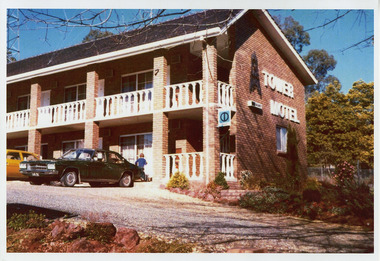 Marysville & District Historical Society
Photograph (item) - Colour photograph, Unknown
A colour photograph of the Tower Motel in Marysville. The Tower Motel was one of the few buildings in Marysville that survived the 2009 Black Saturday bushfires.A colour photograph of the Tower Motel in Marysville.marysville, victoria, australia, tower motel, accommodation, photograph, 2009 black saturday bushfires