Showing 379 items
matching central gardens
-
 Bendigo Historical Society Inc.
Book - MINING REPORTS - THE CONFIDENCE GROUP OF MINES BULLETIN NO 41
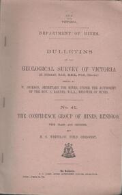
Light brown covered booklet 'Bulletins of the Geological Survey of Victoria issued by W Dickson, Secretary for Mines, Under the Authority of the Hon. S Barnes M L A Minister of Mines. No 41 The Confidence Group of Mines, Bendigo with Plans and Sections by H S Whitelaw, Field Geologist, dated 1918. Mines mentioned are: Confidence Extended Mine, Confidence Tribute Company and the Central Windmill Hill Mine. Mentioned in the report are crushings and gold yield, details of levels, names of leases along the reef. Extracts from Mine Manager's Half-yearly Reports, 1878-1915 of tons crushed and gold yield. Plans and sections of the Confidence Extended Mine on the Garden Gully Line of Reefs are: Plate I General Plan of All Levels, Plans of Levels Plate No II, Plans of Levels Plate No III, Transverse Section Plate No IV, Longitudinal Section Plate No V, and Central Windmill Hill Mine Transverse Section Plate No VI. Plates signed by H S Whitelaw 17 & 18/6/16 and 20/7/16. Booklet if part of the Albert Richardson Collection. book, bendigo, mining reports, mining reports, the confidence group of mines bulletin no 41, confidence extended mine, confidence tribute company, central windmill hill mine, department of mines, bulletins of the geological survey of victoria, w dickson, the hon s barnes, h s whitelaw, h j green, mr robert eddy, mr w h cundy, j foster, c j thompson -
 Bendigo Historical Society Inc.
Document - MINING REPORTS - KENTISH MINE MANAGER'S REPORT
Here on the Garden Gully Line were Bell and Watson’s, the Cornish United, the Victory and George Lansell’s pride, the Pandora. Here too, was the enormously rich Kentish Mine from which its owner, J.B.Watson, was credited with taking some thirteen tons of gold, then worth £1,500,000. At this time, John Boyd Watson was well on the way to becoming not only the richest man in Sandhurst, but probably in the colony. (Extract from North West Victoria Historic Mine Sites, David Bannear, Heritage Victoria, 1991.)Handwritten extracts by Albert Richardson, with typed copy of same, from the Kentish Mine Manager, J. J. Jewell's Report. Extracts dated 1-11-1894 and 9-3-1894. Report mentions crushings and gold yield at the Old Carlisle Shaft and crushings and gold yield from The 'Central' mullock. (b) mentions the baling of water and the Carlisle Shaft, formerly Nth Garden Shaft.document, gold, mining reports, mining reports, kentish mine manager's report, j j jewell, old carlisle shaft, w griffiths & party, nth garden shaft, j cock & party, the 'central' -
 Glen Eira Historical Society
Photograph, Beauville Avenue, 2, Murrumbeena, 2001
Originally labelled "Beauville Estate, Established 1936, Still Thriving 65 years on, 10th March 2001", the Beauville Estate Album contains colour photographs of houses in the Estate. They were taken around the time of the Beauville Estate’s 65th Heritage Celebration held on 10/03/2001 and donated to the Caulfield Historical Society shortly afterwards. Photographer Bev Baxter. City of Glen Eira’s Heritage Management Plan Vol 2 p79 (this is p84 of the pdf version) – HO12 Beauville Estate and environs, Murrumbeena: The Beauville Historic Area is important at the State level as the first large housing estate undertaken by the AV Jennings Construction Co, later Jennings Group Limited, Victoria’s largest home builder. It is important also as a very early estate development incorporating a range of features other than houses and including made roads, shops and recreation facilities. In this respect it was the forerunner of the comprehensively planned housing estate of the post war era. The estate is distinguished by its aesthetic values, as is the earlier and comparable Hillcrest Estate, which are formed by a combination of restrained diversity in house styles, with the exception of no. 30 in the emerging International style, and by a landscaped garden environment. Colour photograph of an unpainted brick house. Other features include a central porch, tiled roof, square paned windows and a low unpainted brick fence in the foreground.murrumbeena, beauville avenue, architectural styles, 1930's, inter war style, a.v. jennings, av jennings, jennings, brick houses, beauville estate, porches, sir albert victor jennings, a v jennings construction co, beauville estate heritage area, glen eira city council, architectural features, jennings group limited, land subdivision, gardens, beauville historic area -
 Bendigo Historical Society Inc.
Document - AUCTION SALES - MINING CATALOGUE AUCTION SALES
BHS CollectionYellow and white patterned, spring back Spirax Students No. 594 Note Book containing extracts from mining Catalogues loaned by Mr. Dyett (J. H. Curnow's). Mines mentioned include Ramrod Gold Mine, Hercules No. 1, Central Blue, South Virginia Extended, Alfords Battery, South New Moon,The Gold Mine Clunes, Guildford Plateau, Big Blue, Spring Gully Mine at Chewton, Eureka Central at Chewton, Bdgo Amalg. Goldfields Limited, Koch's Air Station, Cornish Mine, Carlisle Battery, Victory & Pandora Mine, Garden Gully, Londonderry Mine, Princess Dagmar, Golden Age, Suffolk United, Virginia South Extended, South Red White & Blue, Pitfield Plains Glenfine South Shaft, Adelong Dredge & Leases, Bright Valley Dredge, North Chewton (Chewton), Talbot Alluvials Norbury's No. 2 Shaft, Gordon Gold Mine Inglewood, Post Office Hill Mine Chewton, Carlisle & Whittaker Plant Maldon, Bunninyong, Yandoit Mine, North Chewton, Golden Transverse Bdgo, Yandoit Co., Chapman's Gold Mine Chewton, Ross Creek Extended G. M. Coy (Ballarat).book, bendigo, mining auction sales, auction sales mining catalogue auction sales, j h curnow, mr dyett, a richardson, ramrod gold mine, hercules no. 1, central blue, south virginia extended, alfords battery, south new moon, the gold mine clunes, guildford plateau, big blue, spring gully mine at chewton, eureka central at chewton, bdgo amalg. goldfields limited, koch's air station, cornish mine, carlisle battery, victory & pandora mine, garden gully, londonderry mine, princess dagmar, golden age, suffolk united, virginia south extended, south red white & blue, pitfield plains glenfine south shaft, adelong dredge & leases, bright valley dredge, north chewton (chewton), talbot alluvials norbury's no. 2 shaft, gordon gold mine inglewood, post office hill mine chewton, carlisle & whittaker plant maldon, bunninyong, yandoit mine, north chewton, golden transverse bdgo, yandoit co., chapman's gold mine chewton, ross creek extended g. m. coy (ballarat). -
 Ringwood and District Historical Society
Document - Research Notes, Richard Carter, Land Subdivisions in Ringwood 1890-1950
Handwritten table listing main local pre-1950s subdivisions in the Ringwood area, with estate names, streets, number of allotments for sale, and where known, vendor agent, LP (Lodged Plan) title registration number, and auction/sale date, some with sale price.Pg1 RINGWOOD STATION ESTATE LP3070 (Year?) Station Street, William Street (now Kendall Street), Wantirna Road, Station Street Pg1 RINGWOOD TOWNSHIP ESTATE LP5577 (1913) Station Road (now Warrandyte Road), Pratt Street (part now Aird Street), Whitehorse Road Pg2 RINGWOOD ORCHARD ESTATE LP4315 (1914) Brysons Road, Hillcrest Road, Anzac Avenue, Sulva Road Pg3 RINGWOOD RAILWAY ESTATE LP7522 (1918) Whitehorse Road (now Mount Dandenong Road), Dublin Road, Freeman Street, Patterson Street, Bona Street Pg4 THE RINGWOOD ESTATE LP7578 (1919) Warrandyte Road, Hobart Street, Paxton Street, Arnold Street Pg5 GARDEN FARMS ESTATE (LP?) (1919) Canterbury Road, Armstrong Road, Bungalook Road, Orchard Road, Bayswater Road (now Mountain Highway) Pg6 THE RINGWOOD ESTATE (SECOND SUB-DIVISION) LP7604 (1919) Warrandyte Road, Tamar Street, Derwent Street, Mersey Street Pg7 RINGWOOD STATION ESTATE LP7703 (1919) Bedford Road, Williams Grove (now Lena Grove) Pg8 RINGWOOD TOWNSHIP ESTATE LP8198 (1919) Wantirna Road, Ellison Street, Haig Street, Greenwood Avenue Pg9 EASTFIELD ESTATE (LP?) (1920) Eastfield Road, Longview Road, Pleasant Rise, The Mount Pg10 ELECTRIC RAILWAY ESTATE RINGWOOD LP9473 (1922) Campbell Street, Myrtle Avenue, George Street (now Tudor Court), Henry Street (now Myrtle Avenue), Williams Grove (now Lena Grove) Pg11 RINGWOOD PARK ESTATE LP7884 (1922 - two stages) Wonga Road (now Loughnan Road), William Street, Andrew Street, Harrison Street Pg12 HEATHMONT STATION ESTATE LP11009 (Date? - after 1922) Lisgoold Street, Viviani Crescent, Balrour Avenue, Station Street (now part Heathmont Road and part Wainui Street) Pg13 RINGWOOD RAILWAY ESTATE LP10507 (1923) Whitehorse Road, Sherbrooke Avenue, Burwood Avenue, Bonview Avenue, Heatherbrae Avenue, Grant Crescent Pg14 GARDEN HOMES ESTATE (LP?) (1923) Mullum Road, The Centreway, Wattle Crescent (now Wattle Avenue) Reserve Crescent (now Reserve Road) Pg15 DUBLIN ROAD ESTATE LP11993 (1923) Alexandra Road, Vonadawn Avenue, Green Street, Wood Street, Howard Avenue, Bedford Road, Dublin Road Pg16 CARLINGA ESTATE RINGWOOD LP9620 (1923) Bourke Street, Bond Street, Ringwood Street Pg17 PRATT'S JUNCTION ESTATE (LP?) (1923) Junction Street, Georges Road, Oliver Street, Whitehorse Road Pg18 EAST RINGWOOD ESTATE LP10492 (1923) Bona Street, Patterson Street, Miller Grove, Fairview Avenue, Eastfield Road, Whitehorse Road (now Mount Dandenong Road) Pg19 COLEMAN'S HEATHMONT ESTATE LP9974 (1923) Canterbury Road, Bedford Road, Alvena Crescent, Coleman Street, Leonard Street (now Royal Avenue) Pg20 RINGWOOD HEIGHTS ESTATE LP10506 (1924) Whitehorse Road, Bonview Avenue, Grant Crescent, Hillcrest Avenue, Heatherbrae Avenue, Margaret Street, Mary Street Pg21 EAST RINGWOOD STATION ESTATE LP10551 (1924) Knaith Road, Wenwood Street, Lois Street, Victoria Street, Station Street (now Railway Avenue) Pg22 GRAND VIEW ESTATE LP11019 (1924) Whitehorse Road, Rupert Street, Herbert Street, Leonard Street Pg23 RINGWOOD RAILWAY ESTATE & RINGWOOD HEIGHTS ESTATE - FINAL SECTIONS LP10506 & LP10507 (1924) Whitehorse Road, Sherbrooke Avenue, Burwood Avenue, Bonview Avenue, Heatherbrae Avenue, Margaret Street, Mary Street, Grant Crescent Pg24 RINGWOOD EAST ELECTRIC STATION ESTATE (LP?) (1924) Railway Parade (now Patterrson Street), Federal Road, Howship Avenue (part now French Street), Dublin Road, Rosedale Crescent Pg25 BEDFORD PARK (now Ringwood Secondary College) (LP?) (1924) Bedford Road, Adams Street, Anderson Street, Joyce Street, Graham Road Pg26 CROWN JEWEL ESTATE LP11645 (Private sales after 1924) Mount Dandenong Road, Mirabel Avenue, Valda Avenue, Evon Avenue, Velma Grove Pg27 GRAND CENTRAL ESTATE LP10917 (1925) Heathmont Road, Great Ryrie Street, Douglas Street, Garden Street, Bellevue Avenue Pg28 RINGWOOD (unnamed estate - 1926) Nelson Street, Seymour Street, Whitehorse Road Pg29 EAST RINGWOOD RAILWAY STATION ESTATE (YEAR? - 25 shops 60 villas) Railway Avenue, Dublin Road, Lawrence Grove, Stanley Avenue, Knaith Road Pg30 CHARM VIEW ESTATE (LP?) (year? - after 1926) Canterbury Road, Heathmont Road, Dickasons Road, Bennjett Avenue, Orchid Street Pg31 SUNBEAM ESTATE LP12150 (Circa 1925) Govt Road (now Old Lilydale Road), Sunbeam Avenue, Holland Road, Everard Street (now Everard Road) Pg32 FAIRVIEW ESTATE EAST RINGWOOD LP10853 (Circa 1924) Eastfield Road, Patterson Street, Margaret Street (now Short Street) Pg33 EAST RINGWOOD TOWNSHIP ESTATE LP3025 (Circa 1924 - 35 allotments) Mount Dandenong Road, Grey Street, Eastfield Road Pg34 EAST RINGWOOD TOWNSHIP ESTATE LP3025 (Circa 1924 - 49 allotments) and STATE SCHOOL ESTATE (26 allotments) and EAST RINGWOOD STATION ESTATE (14 shop sites) Mount Dandenong Road, Grety Street, Dunn Street, Eastfield Road, King Street, Holland Road, Dublin Road, Patterson Street, Bona Street Pg35 EAST RINGWOOD CENTRAL ESTATE LP17004 (1948) Knaith Road, Shasta Avenue, Talofa Avenue, Russet Road, Dublin Road Pg36 WARE ESTATE LP43360 (1958) Ware Crescent, Davey Drive, Grey Road (now Grey Street), Mount Dandenong Road Pg37 Lot 57 Kendall Street LP3070 (1939) £75.0.0 Pg37 Lot 14 LP7346 (year?) £225 Pg37 Lot 8 WHITE HORSE ESTATE LP14010 (year?) Maroondah Hwy, Seymour Street £98.9.0 Pg37 Lots 4-14 incl. LP10902 (year?) £300 Pg37 Lots 69&70 LP2216 (1939) Bedford Road, Pitt Street £500 Pg37 Lots 60&70 LP2216 (year?) £460 Pg37 MOUNTAIN VIEW ESTATE LP10902 (1936) Lots 1&2, 19-22 Wantirna Road, Daisy Street £50 Pg38 RAILWAY STATION ESTATE RINGWOOD EAST LP7522 (1925) Lots 16 to 19 £250 Pg38 RINGWOOD PARK ESTATE (LP?) (1924) Lot 112 Munro Street £230 Pg38 RINGWOOD TOWNSHIP ESTATE (LP?) (1925) Lot 57 Wantirna Road £850 Pg38 ELECTRIC RAILWAY ESTATE LP9473 (1925) Lot 98 & 99 £180 (30/- foot) Pg38 ELECTRIC RAILWAY ESTATE LP9473 (year?) Lot 100 £233.12.6 incl improvements (£2.12.6 foot) Pg38 Lot 22&23 Bedford Road Heathmont (LP & year?) £675 incl improvements Pg39 Lot 9 Mullum Mullum Road LP8221 (1923) £150 Pg39 Lot 27 Haig Street LP8198 (1925) £825 Pg39 Lot 56 Haig Street cnr Wantirna Road LP8198 (1923) £171 Pg39 Lots 3 & 4 Loughnan Road LP9626 (192?) £147 Pg39 Lots 98 & 99 Myrtle Avenue LP9473 (1925) £180 Pg39 Lots 80 & 81 Myrtle Avenue LP9473 (1929) £150 Pg39 Lot 30 Sherbrooke Avenue LP10507 (1926) £700 incl improvements Pg40 Lot 10 (year?) LP7703 £750 Pg40 Lot 36 (year?) LP7522 £25 Pg40 Lot 38 Pitt Street LP2216 (year?) £350 Pg40 Lot 7 Dublin Road cnr Green Street LP11993 (year?) £300 -
 Bendigo Historical Society Inc.
Document - MINING REPORTS - REPORT ON MINES DEC. 1ST 1966
Handwritten notes, with typed copy, listing 14 reports on mines and locality plans. If it was decided to have postcards of some famous mines, there is a suggestion of how they could be set out. Also a paragraph thanking the Mine's Dep't, Miss Parry and Mr. E. Jackman for work they have done.document, gold, mining reports, mining reports, report on mines dec 1st 1966, carlisle united, central nell gwynne, central red white and blue, fortuna hustlers, garden gully united, gt extended hustlers, lady barkly, new argus, new chum railway, new chum syncline, new moon, new red white and blue consolidated, south new moon, united hustlers and redan, mine's dep't, miss parry, mr e jackman -
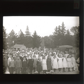 The Beechworth Burke Museum
Photograph - Lantern Slide, c1900
This glass slide depicts a group of school children standing in Queen Victoria Park (previously Beechworth Botanic Gardens), circa 1900. Queen Victoria Park was first secured in 1858 by the Beechworth Council with the assistance of the Central Board of Health (CBH). The CBH was a firm believer in the socially beneficial effects of parks and other recreation areas which is why they aided the council in securing the parkland. the council held a local competition for the design of the park and decided on a plan called "Better late than never" by Hungarian nobleman, J.A. Rochlitz. The first non-native trees were planted in 1861 and have since been heritage listed on the National Trust's register of significant trees. There are nine trees located in Queen Victoria Park that are currently on the National Trust's register. These are the Loblolly Pine, Italian Cypress, Shore Pine, and the Big Cone Pine. These trees hold significance as they date back to 1875 and show rare and localised examples of these types of species which are not seen in many other places in Victoria. The trees in the background of the glass slide depict a species of the pine tree and may be some of the trees still standing in Queen Victoria Park today.This glass slide captures social and historical significance as it not only captures a moment in time of these school children, but it also shows environmental significance for the heritage trees depicted in the background.burke museum, beechworth, lantern slide, slide, glass slide, plate, burke museum collection, photograph, monochrome, queen victoria park, indigo shire, school, j.a. rochlitz, beechworth council -
 University of Melbourne, Burnley Campus Archives
Plan, Plan of Richmond Park, 1886-1948
(1) Black and white photographed copy of an original coloured plan. Plan of Richmond Park with Horticultural Society Gardens marked in. Includes additional land which became the Field Station. Original plan dated 31 August 1872, note of Crown Grant to the Board of Land & Works and Richmond City Council 1886; showing land, "Permanently Preserved for the Gardens". Stamp, "Department of Lands and Survey Photographed at the Central Plan Office 1/1 Plate 7.12.48" (2) Also 2 photocopies, 1 reduced - possibly used in a publication1 photocopy has "Figure 1. Plan of Burnley Gardens circa 1863 [sic]gardens, richmond, horticultural society of victoria, richmond park, a.l. martin -
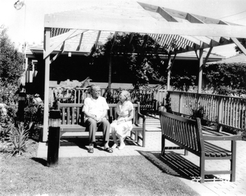 Broadmeadows Historical Society & Museum
Photograph, Meeting Place, Banksia Gardens Estate, Broadmeadows 1998, 22 January 2025
The meeting place at Banksia Gardens Estate in Broadmeadows, captured in 1998, holds significant historical value. This public housing area, where people gathered at the pergola, serves as a testament to the community spirit and social interactions that were central to the estate's external development. The photograph records the evolution of Banksia Gardens, highlighting its role as a hub for community engagement and support. It reflects the importance of creating accessible and inclusive spaces that foster social connections and enhance the quality of life for residents.The meeting place at Banksia Gardens Estate in Broadmeadows, captured in 1998, holds significant historical value. This public housing area, where residents gathered at the pergola, exemplifies the community spirit and social interactions that were integral to the estate's external development. The photograph documents the evolution of Banksia Gardens, highlighting its role as a central hub for community engagement and support. It underscores the importance of creating accessible and inclusive spaces that foster social connections, enhance the quality of life for residents, and contribute to the overall development of the community.Black and white photograph on glossy photograph paper.Public housing where people meet at the Pergola/Banksia Gardens, 1998banksia gardens, broadmeadows, 1998, public housing -
 University of Melbourne, Burnley Campus Archives
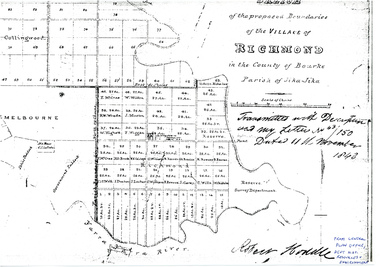
Plan - Photocopy, Sketch of the Proposed Boundaries of the Village of Richmond, 1843
Sketch of the proposed boundaries of the village of Richmond in the County of Bourke Parish of Jika-Jika. Handwritten on original: "Transmitted with Description and my letter No 43/150 Dated 11th November 1843 Robert Hoddle." Shows Burnley Gardens site as "Reserve. Survey Department." original in Central Plan Office, Department of Natural Resources and EnvironmentIn ink: From Central Plan Office Dept. Nat. Resources & Environmentrichmond, jika-jika, survey department, yarra river, robert hoddle -
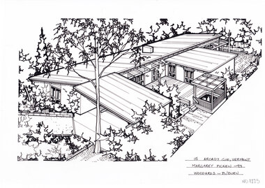 Whitehorse Historical Society Inc.
Artwork, other - Ink Line Drawing, Margaret Picken, 15 Arcady Gve., Vermont, 1993
A property illustration by Margaret Picken Commissioned by a real estate agency for the purpose of advertising 15 Arcady Gve., Vermont This property is listed as having sold for $178,000 in 1995 Made by using Rotring ‘Rapidigraph’ drafting pens with Rotring ink on Rapidigraph polyester drafting film, double matte. Trained as a cartographic draftsman within the mining industry, Margaret Picken is an artist who worked producing property illustrations for real estate agencies in eastern suburbs of Victoria from 1983-2005. Retiring from the industry as technological changes favored coloured photography over illustrations, and commissioning companies over sole contractors.This artwork is of Historical Significance as a record of local domestic architecture.A black ink line drawing on drafters film by Margaret Picken, of a black and white line drawing of a single story brick house from a angled birdseye view, on a left to right diagonal. On the left, a horizontal driveway leads to a connected carport, with the main of the house of the left. Wrapping around a central decked courtyard. There is a backyard in the background in the upper right corner. There are two hole punch holes just below centre of the upper edge15 Arcady Gve., Vermont Margaret Picken -93 Woodards - B/Burnwhitehorse historical society, schwerkolt cottage, housing, architecture, margaret picken, house, garden, real estate, vermont -
 Whitehorse Historical Society Inc.
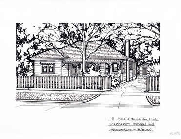
Artwork, other - Ink Line Drawing, Margaret Picken, 8 Menin Road., Nunawading, 1997
... , with garden beds and central tree. There are two holepunch holes.... In the foreground is a front garden, with garden beds and central tree ...A property illustration by Margaret Picken Commissioned by a real estate agency for the purpose of advertising 8 Menin Road., Nunawading. This property is listed as having sold for $225,000 in 1997 Made by using Rotring ‘Rapidigraph’ drafting pens with Rotring ink on Rapidigraph polyester drafting film, double matte. Trained as a cartographic draftsman within the mining industry, Margaret Picken is an artist who worked producing property illustrations for real estate agencies in eastern suburbs of Victoria from 1983-2005. Retiring from the industry as technological changes favored coloured photography over illustrations, and commissioning companies over sole contractors.This artwork is of Historical Significance as a record of local domestic architecture.A black ink line drawing on drafters film by Margaret Picken, of a black and white line drawing of a single story weatherboard house with bullnose verandah covering the front porch. On the right is a driveway leading to a separate garage in the background. In the foreground is a picket fence enclosing the front garden. black and white line drawing of a single story weatherboard house, with a driveway on the right leading to a separate garage in the background. In the foreground is a front garden, with garden beds and central tree. There are two holepunch holes on just under the upper edge.8 Menin Road., Nunawading Margaret Picken - 97 Woodards - B/Burnwhitehorse historical society, schwerkolt cottage, housing, architecture, margaret picken, house, garden, real estate, nunawading -
 Lakes Entrance Historical Society
Photograph - Central Flats Lakes Entrance, Wally Stephenson, 1982 c
Also another colour photograph taken of west side of Myers Street showing Silver Sands Caravan Park 05209.1Colour photograph of Lakes Central Flats on corner of Myer Street and Church Street looking West from Police Station showing flowers in garden at roundabout Lakes Entrance Victoriahousing -
University of Melbourne, Burnley Campus Archives
Plan - Photocopy, Proposed Reserve for Horticultural and Experimental Garden in the Survey Paddock Richmond, 1862-1948
Photocopy of Plan Gazetted 01.08.1863. From Central Plan Office Department of Natural Resources.Original signed by Clement Hodgkinson, Deputy Surveyor General. Stamped Department of Lands and Survey 7.12.48 Neg.18377. Handwritten notes on back "Melb Roll 23, R.19(A)"burnley, horticultural and experimental garden, survey paddock, richmond, clement hodgkinson -
University of Melbourne, Burnley Campus Archives
Plan - Photocopy, Contour Map 1891, 1891
... of the garden design. From Central Plan Office Dept. of Natural... and Principal's Residence but not much of the garden design. From Central ...Photocopy of plan showing contour lines from Yarra River. Shows Pavilion and Principal's Residence but not much of the garden design. From Central Plan Office Dept. of Natural Resources."Contour map 1891" written in biroyarra river, pavilion, burnley horticultural college, burnley gardens -
 Bendigo Historical Society Inc.
Document - NEW CHUM & VICTORIA LINES OF REEF - BENDIGO GOLDFIELD
Handwritten notes listing Bendigo Mines, their years of operation, ounces of gold taken out, Dividends, Calls, and depth of shaft. Some of the mines only have the year they ceased operations mentioned. Dated 1/3/67. Also, a typed copy.document, gold, new chum & victoria lines of reef, new chum & victoria lines of reef, bendigo goldfield, mines dept, new chum cons, new chum united, eureka extd, south belle vue, old chum, new chum & victoria, lansell big 180, ellenborough, st mungo, sth st mungo, little 180, mining register 1893 - 1902 m d annual reports 1902 on, mines dept quarterly to 1892, south new moon, hercules, ironbark, ironbark south, central r w & blue, stanfield, hercules no 1, north nell gwynne, new chum syncline, central nell gwynne, carshalton b m l, napoleon bml, nell gwynne bml, nell gwynne reefs, monument hill, central deborah, north deborah, deborah, south deborah, neangar, lightning hill, alliance, shellbach, south virginia, catherine reef united, belmont & saxby, lady barkly, unity, vict quartz, new argus, new chum railway, garden gully united -
 Bendigo Historical Society Inc.
Document - NEW CHUM & VICTORIA LINES OF REEF - NEW CHUM & VICTORIA LETTER & NOTES
Handwritten letter to Mr. Blake with reference to meeting students and the changes in Bendigo. Mentioned are the Log Lock-Up, the Central Deborah Mine, the ex-manager of the mine, Mr. Rowe acting as a guide, Victoria Hill and the Bendigo Pottery. The notes titled ''To replace Around the Goldfields'' mentions the Third Edition, 'Historic Guide to Bendigo', published in 1969 of land reclamation schemes rapidly removing all traces of several mines. Those affected on the New Chum Line of Reef are: The Victoria Consols, Ironbark and Hercules and Energetic. The Sheepshead Line - the Ironbark and Ironbark South. On the Garden Gully Line - The Cornish United, Koch's Pioneer and Confidence Extended. The Paddy's gully Line - The British American, Lansell's Sandhurst (Needle) and the Collman and Tacchi. On the Derby Line - Johnson's No 3 (Nelson) and on the Hustlers Line are the United Hustlers and Redan and the K. K. Mines. Also, a carbon copy of the notes.document, memo, new chum & victoria letter & notes, mr blake, mr hattam, log lock-up, central deborah mine, mr rowe, victoria hill, bendigo pottery, historic guide to bendigo third edition, new chum line of reef, the victoria consols, ironbark, hercules and energetic, sheepshead line, ironbark, ironbark south, garden gully line, cornish united, koch's pioneer, confidence extended, paddy's gully line, the british american, lansell's sandhurst (needle), collman and tacchi. derby line, johmson's no 3 (nelson), hustlers line, united hustlers and redan, k k mines -
 Bendigo Historical Society Inc.
Document - VICTORIA HILL - SELF TOUR OF GOLDFIELDS NO 1
... Deborah, Central Deborah, The Fortuna Hustlers, Hustlers Royal..., Garden Gully United, Central Nell Gwynne, The Old Chum, The New ...Two copies (a & b) of a Royal Historical Society of Victoria, Bendigo Branch Self Tour of Goldfields No 1. The guide is to enable the tourist to locate and see for himself some of the gold mining area of Bendigo. Mines mentioned are: Deborah, North Deborah, Central Deborah, The Fortuna Hustlers, Hustlers Royal Reserve (City Mine), Great Extended Hustlers, The Hustlers Reef, Lansell's Comet, The United Hustlers and Redan, Garden Gully United, Central Nell Gwynne, The Old Chum, The New Chum and Victoria, The Lazarus, The New Chum United, The New Chum Consolidated, The Garibaldi, Advance, Lansell's 180, The Victoria Quartz, North Old Chum, The Ironbark, The Hercules, The Carlisle United, The Mungo Group, The Ellenborough, The St. Mungo, The Lady Barkly, South St. Mungo. Notes also include wages at the Fortuna Hustlers in 1906 and 1907, gold yield, depth of shaft, Dividends and Calls. Notes compiled by Mr. A. Richardson.document, gold, victoria hill, self tour of goldfields no 1, deborah (big deborah), north deborah, central deborah, the fortuna hustlers, hustlers royal reserve (city mine), great extended hustlers, the hustlers reef, lansell's comet, the united hustlers and redan, garden gully united, central nell gwynne, the old chum, the new chum and victoria, the lazarus, the new chum united, the new chum consolidated, the garibaldi, advance, lansell's 180, the victoria quartz, north old chum, the ironbark, the hercules, the carlisle united, the mungo group, the ellenborough, the st. mungo, the lady barkly, south st. mungo, hustlers hill, new chum hill, jonathan harris, j hustler, messrs latham and watson, buckell & jeffrey, camp hill school, mechanics institute eaglehawk, duke of edinborough, geo lansell, the k k shaft, williamsons, little's claim, rosalind park, mr pryor, gold mines hotel, burrowes and sterry, bonatti, menzies, hildebrant and koch's, ellesmere, p m g repeater station, mr lazarus, mt alvernia hospital, mr clarke magee, rae's, jeweller's shop, hopetoun band room, manchester arms hotel, wattle gully mine chewton, long gully post office, 'pope pius' roman catholic church, kentish, mr j b watson, california gully state school, duke of edinborough, new st mungo, duchess tribute, south devonshire, duchess of edinborough, west united devonshire, united devonshire, princess alexandra, hopewell, miners' phthisis, bendigo goldfields, mr a richardson -
 Bendigo Historical Society Inc.
Document - MINING REPORTS - KENTISH MINE MANAGER'S REPORT
Handwritten extracts from the Kentish Mine Manager, J. Jewell's Report. Items mentioned are water baling, firewood, Robinson Street, sinking preparations, too hot to work, total depth of shaft, mullock and the Old Carlisle Shaft.document, gold, mining reports, kentish mine manager's report, j jewell, j cock & party, central mullock, carlisle shaft, north garden shaft, old carlisle shaft, w griffiths & party