Showing 445 items
matching clearing
-
 Monbulk Historical Society
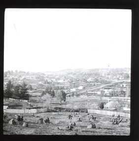
Ben Simcox
Bennie Simcox first came to the Monbulk area about 1860, following the first important gold discovery at the end of 1858. As the gold rush was short lived Simcox returned to Collingwood but later came back to Monbulk, built himself a hut to live in and become its first known permanent resident. The hut was burnt in the 1913 fires. Monbulk was thrown open to selection in 1894, and that's when the first farmers including Bennie Simcox went into Monbulk. It was a big, timbered country in those days. Once Ben had cleared some of his land he started to grow raspberries on it. He would be up before daylight ready to start picking. Ben also picked for a local family, the Camms to help make ends meet. When Ben Simcox was virtually at the retired stage, he wanted to develop his bit of the gully as a tourist attraction, As his nephew Fred Gay who owned the 10 acres below Ben wanted to farm, he was happy to swap his treed block with Ben. At a time when most settlers were clearing their properties, Ben Simcox, by contrast, cultivated the native plants and planted most of the large trees seen on the property today. And so Nathania Springs was developed as a tourist resort, and a mini-botanical garden. He diverted the natural water supply to form ornamental garden pools stocked with trout and tame native black fish. There were many visitors came to the Dandenongs, Some arriving in motor cars others in converted furniture vans lined with seats or charabancs with the long extended chassis and the open canvas roofs. Identities such as Billy Hughes, Madame Melba would often come to look through Nathania Springs. Bennie sold Nathania Springs to Councillor Ferdinand Thomas Le Juge, a boarding house proprietor and later the town baker in 1909 then in about 1921 Ben’s nephew Fred and his wife and family continued to open Nathania Springs to the public. It was not unusual in around 1924-25 for up to a thousand people a day to arrive at Nathania Springs to go through the gardens. At sixpence a time, that was a lot of money in those days. This photo is part of a collection of historic and social significance of the early settlement of Monbulk. Copies of photographs can be purchased from the Monbulk Historical Society.simcox, nathania springs, monbulk, 1860, berries -
 The Beechworth Burke Museum
Photograph - Lantern Slide, c1900
Miners from Snake Valley lobbied the Victorian Government in 1855 to make land available for sale for farming purposes as an alternative occupation and income for people who wished to stay in the region but move away from gold mining. A secondary motivation was to increase the supply of fresh produce and decrease prices of items that otherwise needed to be transported from Melbourne or other regions. Forty-three country lots were initially offered in the Three Mile area, ranging in size from two to ninety acres and costing from £1 to £3 per acre. An additional eighty-five country lots were auctioned later in the year, in addition to many smaller suburban lots. More lots were offered than sold, initially, but this represented conditions of sale requiring the total purchase cost up front which many people interested in purchasing could not afford, especially as land purchased for farming would accrue substantial additional costs for clearing and labour before becoming productive. Further lobbying activities and the election of parliamentary members sympathetic to the cause took place through the 1850s. Ovens Parliamentary Member, Daniel Cameron, was re-elected in 1856 on a platform of surveying the land for public selection with deferred payment options. Land reform remained an issue in the area through the 1850s and early 1860s, impacting broader decisions in the new State of Victoria relating to voting rights, use of Crown land and the farming of land that wasn't always suitable for the purpose. This photograph depicts Beechworth in approximately 1900, after several waves of land sales resulted in increasingly levels of development. Lantern slides, sometimes called 'magic lantern' slides, are glass plates on which an image has been secured for the purpose of projection. Glass slides were etched or hand-painted for this purpose from the Eighteenth Century but the process became more popular and accessible to the public with the development of photographic-emulsion slides used with a 'Magic Lantern' device in the mid-Nineteenth Century. Photographic lantern slides comprise a double-negative emulsion layer (forming a positive image) between thin glass plates that are bound together. A number of processes existed to form and bind the emulsion layer to the base plate, including the albumen, wet plate collodion, gelatine dry plate and woodburytype techniques. Lantern slides and magic lantern technologies are seen as foundational precursors to the development of modern photography and film-making techniques.This glass slide is significant because it provides insight into Beechworth's built environment and infrastructure in the early Twentieth Century, around the time of Australia's Federation. It is also an example of an early photographic and film-making technology in use in regional Victoria in the time period.Thin translucent sheet of glass with a square-edged image printed on the front and framed in a black backing. It is held together by metal strips to secure the edges of the slide.burke museum, beechworth, lantern slide, slide, glass slide, plate, burke museum collection, photograph, monochrome, indigo shire, north-east victoria, farming, squatters, miners, agriculture, land-clearing, land reform, daniel cameron, land sales, three mile, snake valley, tarrawingee -
 Eltham District Historical Society Inc
Film - Video (DVD), Nillumbik Shire Council, Edendale Farm Community Environment Centre: History, c.2009
EDENDALE FARM Edendale Farm is Nillumbik Shire Council's environment centre situated in Gastons Road, Eltham between the railway and the Diamond Creek. The homestead on the property was built in 1896 and is of historical significance, being the subject of a Heritage Overlay under the Nillumbik Planning Scheme. The Edendale property was originally part of an extensive land purchase in 1852 from the Crown by pioneer Eltham farmer Henry Stooke. He initially purchased 51 acres and later expanded his holdings by purchasing another three adjacent Crown allotments extending northerly from Josiah Holloway's Little Eltham subdivision. Despite clearing the land, Stooke did not build on this property, choosing to live on his property "Rosehill" at Lower Plenty. In 1896 Thomas Cool, Club Manager of the Victoria Coffee Palace in Melbourne purchased 7 acres of the original Stooke land and built the house now known as Edendale. Cool did not farm the land, instead using it as a gentleman’s residence, retiring to Eltham at weekends. In 1918 he purchased an additional 7 acres but in 1919 he sold the property. Later owners included J.W. Cox, the Gaston family and D. Mummery. In the 1980s the Eltham Shire Council purchased the site for use as a Council depot, but this use did not proceed. Subsequently, it was used as the Council pound. The Edendale Farm Pet Education and Retention Centre was established in the summer of 1988/1989 and was set up to replace the existing dog kennels with a high standard pet retention centre. The design style of the building was established to compliment the features of the existing house. It was equipped with 10 retention pens, a veterinary room and a pet education area where school children and other interested parties learnt about pet care procedures. It was later developed into a community farm and was run by an advisory committee and in 2000 it became an Environment Centre. In early 2006 an advisory committee was established for the development of a master plan for future development at Edendale Farm. The committee included Russell Yeoman, a former long-time shire planner and founding member of the Eltham District Historical Society. At the time of filming the Master Plan and future for Edendale was about continuing to develop Edendale as a centre of environment learning and looking at expanding displays and school program, running a lot more of life-long learning and workshops around sustainable living.edendale community farm, eltham, gastons homestead, gastons road, shire of nillumbik, video recording -
 Federation University Historical Collection
Work on paper - Cartoons, Edwin Cannon, World War One Cartoons by Edwin Cannon, 1916, 1916
Edwin (Ted) Cannon was born at Ballarat on 30 July 1895, the only son of Edwin and Florence Cannon. He studied art at the Ballarat School of Mines Technical Art School. Ted displayed a talent for industrial design but it was his black and white work that 'drew' most attention. His cartoons and caricatures, heavily influenced by Phil May, were of a particularly high standard. During the Ballarat Exhibition of 1913 Ted's work was singled out for notice and he was awarded First Prize. After completing his art course Ted was employed as an assistant teacher at the Ballarat Technical Art School, before taking a position as cartoonist with the Ballarat Star newspaper at the end of 1914. With the war raging in Europe Ted discovered a darker aspect for his artwork, but, still, he could not resist depicting Turkey as a full-feathered, fez-wearing bird. In 1915 Ted was awarded the prestigious Victorian Education Department Senior Technical School Scholarship. Only months into his scholarship, Ted volunteered for the AIF. A keen member of the local 71st "City of Ballarat" Regiment Ted was already primed for a life in the army. He embarked from Port Melbourne on 23 November 1915 with reinforcements to the 6th Infantry Battalion bound for Egypt. It was during the Battle of Pozieres on the Western Front that Ted Cannon came into his own. His work with the Scout Platoon (under the command of Lieutenant Jack Rogers) sketching the enemy's gun emplacements proved invaluable to the Brigade and brought Ted to the attention of the Australian High Command. On 13 September 1916 Ted was given a special assignment for General C.B.B. White. Ted was sent out forward of the Old Mill at Verbrandenmolen (in the Ypres Salient) to draw a panorama of the German lines in the area from Hill 60 to The Bluff. It was a hazardous task and Ted was warned to be careful. Tragically he was sniped by an enemy machine-gunner and sustained severe abdominal wounds. Stretcher-bearers rushed him to the 17th Casualty Clearing Station where he was operated on by the doctors at 8.30 that night. With little chance of success, but ever resilient, Ted remained conscious almost to the end. He died early in the morning of the 14 September 1916. His body was buried in the large Military Cemetery at Lijssenthoek. See http://www.ballarat.edu.au/about-ub/history/art-and-historical-collection/ub-honour-roll/c/edwin-joseph-ted-cannon-1895-1916Digital images of a number of cartoons published in the Ballarat School of Mines Students' Magazine, 1916. Ted Cannon sent cartoons home to Ballarat from the World War One front.edwin cannon, ted cannon, cartoons, world war, world war 1 -
 Victorian Interpretive Projects Inc.
Cartoons, World War One Cartoons by Edwin Cannon
Edwin (Ted) Cannon was born at Ballarat on 30 July 1895, the only son of Edwin and Florence Cannon. He studied art at the Ballarat School of Mines Technical Art School. Ted displayed a talent for industrial design but it was his black and white work that 'drew' most attention. His cartoons and caricatures, heavily influenced by Phil May, were of a particularly high standard. During the Ballarat Exhibition of 1913 Ted's work was singled out for notice and he was awarded First Prize. After completing his art course Ted was employed as an assistant teacher at the Ballarat Technical Art School, before taking a position as cartoonist with the Ballarat Star newspaper at the end of 1914. With the war raging in Europe Ted discovered a darker aspect for his artwork, but, still, he could not resist depicting Turkey as a full-feathered, fez-wearing bird. In 1915 Ted was awarded the prestigious Victorian Education Department Senior Technical School Scholarship. Only months into his scholarship, Ted volunteered for the AIF. A keen member of the local 71st "City of Ballarat" Regiment Ted was already primed for a life in the army. He embarked from Port Melbourne on 23 November 1915 with reinforcements to the 6th Infantry Battalion bound for Egypt. It was during the Battle of Pozieres on the Western Front that Ted Cannon came into his own. His work with the Scout Platoon (under the command of Lieutenant Jack Rogers) sketching the enemy's gun emplacements proved invaluable to the Brigade and brought Ted to the attention of the Australian High Command. On 13 September 1916 Ted was given a special assignment for General C.B.B. White. Ted was sent out forward of the Old Mill at Verbrandenmolen (in the Ypres Salient) to draw a panorama of the German lines in the area from Hill 60 to The Bluff. It was a hazardous task and Ted was warned to be careful. Tragically he was sniped by an enemy machine-gunner and sustained severe abdominal wounds. Stretcher-bearers rushed him to the 17th Casualty Clearing Station where he was operated on by the doctors at 8.30 that night. With little chance of success, but ever resilient, Ted remained conscious almost to the end. He died early in the morning of the 14 September 1916. His body was buried in the large Military Cemetery at Lijssenthoek. See http://www.ballarat.edu.au/about-ub/history/art-and-historical-collection/ub-honour-roll/c/edwin-joseph-ted-cannon-1895-1916 Digital images of a number of cartoons published in the Ballarat School of Mines Students' Magazine, 1916. Ted Cannon sent cartoons home to Ballarat from the World War One front.edwin cannon, ted cannon, cartoons, world war, world war 1 -
 Bendigo Historical Society Inc.
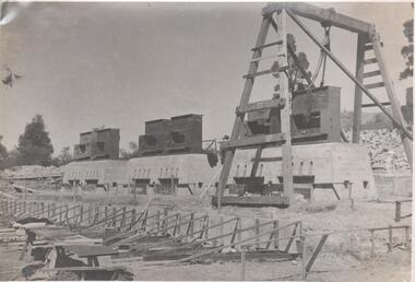
Photograph - Napoleon Reef Gold Mine Battery Site, 1936
The Napoleon (BML) gold mine (1932) was located near McDougall Road, Golden Gully, between Martin and Hattam Street. It had a depth of 921 feet. It was one of the latest and most lavish of Bendigo's mines. Plant and equipment were electrically driven. The four-compartment shaft, extra large by goldfield's standards, measured 17 feet 6 inches by 5 feet 2 inches and was cement lined below 900 feet instead of being red gum boxed as was the usual practice. The workshop was equipped to carry out all repairs for the equally lavish BML mines on the Nell Gwynne and Carshalton reefs. (The Gold Mines of Bendigo, Book 2, Arthur Victor Palmer) 'Napoleon BML Mines No Liability have issued a report for the fortnight ended September 5, where it states that the development scheme has been formulated and necessary equipment is being ordered. The Napoleon main shaft, (about 1700 feet south of the old Napoleon shaft) will be a four compartment shaft (17ft 6 inches by ft 2 inches inside the timber). aLevels will be opened at approximately 100 ft vertical intervals and cross-cuts extended approximately 125 ft each side of centre country to explore a cross-section across the anticline opposite to the shaft. At every fifth level, main drives will be extended north to connect with the old Napoleon shaft and south approximately 1800 ft. At the latter point, another cross-section of the anticline will be explored by rising and cross-cutting. The old Napoleon will be unwatered and on the 500ft and 1000 ft levels main drives will be driven to connect with main levels from the Napoleon main shaft to the south as well as being driven north 1800 ft where another cross-section of the anticline will be explored. Cross-sections further north and south may be developed as desired and also at intermediate points if necessary. Clearing and grading of the main shaft site are now in progress and the erection of the office and store building is proceeding. The design of engine room, change house and machine shops is now in hand and erection will proceed as soon as working plans and specifications are prepared.' The main shaft has been commenced at 3ft and advanced 10 ft. to 13 ft. https://trove.nla.gov.au/newspaper/article/10975478?searchTerm=napoleon%20bml (The Argus, 8th. September 1934, 'Mining' page 18) Significant to mining history of Bendigo.Black and white photograph of a stamper head being lowered into position on the battery site of the Napoleon Reef Gold Mine. A wooden gantry supports the battery head as it being lowered. Three large concrete foundations are visible in immediate background, two of which have stampers already in position, the third stamper is being lowered onto the final foundation. In immediate foreground, 'boxing' is erected for future concrete pours. napoleon gold mine, napoleon reef gold mine -
 Flagstaff Hill Maritime Museum and Village
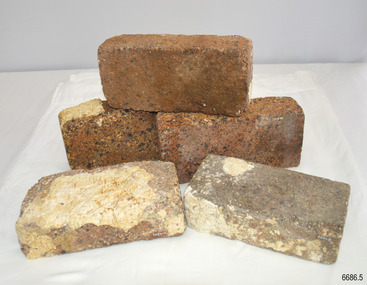
Ceramic - Clay Bricks, Circa 1838
These bricks are a sample of “5000 house bricks from London” carried by the CHILDREN as ballast, and intended for the Portland Bay settlement of her owners Henty Bros. Flagstaff Hill divers recovered them from Childers Cove in February 1974, and noted, “These bricks are the major feature of the wreck site. Subsequent notes indicate “The hull structure has broken up, leaving few visible remains, except for piles of house bricks intended for the Hentys of Portland”. According to Lloyds Shipping Register 1837-1839, the CHILDREN was built in 1825 at Liverpool and operated by owners Gordon & Co, of London, London registered number 123/1837; James Henty then bought her in 1837 as a three-masted barque of 254 tons, with a hull of “part pitch pine, felt sheathed” and “coppered 1837”. Launceston registered number 6/1837; in 1838 the CHILDREN, under her master Captain H. Browne, completed a successful round trip from Launceston to London (carrying wool and whale oil loaded in Portland), returning in late November of that year (carrying general cargo including the house bricks). On the 11th of January 1839, the CHILDREN sailed from Launceston for Adelaide, with 24 passengers, 14 crew, and an awkward mixed cargo, including 1500 sheep, 8 bullocks, 7 horses, and farming implements, and six whaleboats with associated whaling gear. One account states that when the CHILDREN “put out from port she was light and badly ballasted”. The vessel immediately encountered four days of hurricane-force storms, eventually clearing on the early morning of the 14th to “west force 10”, but too late to take accurate measurements of the sun or stars to establish their position relative to the coast. The CHILDREN collided with a limestone stack at the entrance of Childers Cove, and the seas smashed her into pieces within half an hour. All the cargo and 16 lives were lost (including 8 children). The Hentys contributed £150 towards a fund for the 22 survivors at a memorial service held in Launceston later that year. It was a major financial setback for the Hentys, but one from which they recovered. In a submission to the Governor of New South Wales dated 24 March 1840, the Hentys summarised their work over the previous six years of settlement: “Six stations have been occupied, one at Portland Bay…three at the open country about 60 miles inland called ‘Merino Downs’…They have erected two houses at Portland Bay and two others at Merino Downs”.These bricks are significant as a sample of 5000 house bricks carried from London as ballast by the Children and were intended for the Portland Bay settlement of her owners James Henty & Co. The CHILDREN was one of the first vessels to be lost in the Western District of Victoria, east of Warrnambool, on January 14th 1838, breaking up within twenty minutes. The wreck is also significant as one of the first vessels to have been lost in the Western District of Warrnambool and as such is registered on the Victorian Heritage Register S116.Five ‘house bricks from London’, some with white marine encrustation, recovered from the wreck of the ship CHILDREN. The bricks are oblong shaped and constructed of a blue-coloured and coarse-grained conglomerate. One brick is higher, shorter and narrower, than the other four bricks.Nonewarrnambool, shipwreck coast, flagstaff hill, shipwrecked coast, flagstaff hill maritime village, flagstaff hill maritime museum, shipwreck artefact, maritime museum, london house bricks, children shipwreck, james henty and co, henty brothers, childers cove, early shipowreck -
 National Vietnam Veterans Museum (NVVM)
Poster - Poster, Information Board, 5 RAR 1966 - 1967 (1st Tour)
An Poster, Information Board of 5 RAR 1966 to 1967 (tst Tour). The 5th Battalion Royal Australian Regiment ("Battalion") were the leading element of the First Australian Task Force (1 ATF) and stationed in Vietnam from 1966 to 1967. The Battalion's task was to break Viet Cong control over the central region of Phuoc Tuy Province - an area that communists had freely operated in since 1945. Commencing of the 24th May 1966, the Battalion conducted its first operation codenamed "Hardihood". Their objective was to sweep and clear areas to the north and east of Nui Dat to a distance of 5000 meters, then create a defensive position to enable 1 ATF to establish an operation base. The Battalion conducted eighteen full-lenght operations as well as numerous day and night cordon and search, search and destroy, ambush and clearing patrols conducted at company, platoon and section levels. the Battalion achieved considerable success during Operations Canberra and Queanbeyan in October 1966 when it swept and cleared the Nui Thi Vai mountain. A Viet Cong base consisting of training facilities, a hospital, booby trap factory and several tonnes of rice was located and destroyed. during phase two (Operation Queanbeyan) the battalion discovered complex cave and tunnel systems along with other fixed installations that were vigorously fought for and destroyed by the battalion. Not only di the caves contain large quantities of weapons, equipment and documents but the 274 VC Regiments deputy commanders radio complex. For bravery and leadership, three Military Crosses, one Military Medal and one Mentioned in Dispatches were awarded. The last was awarded posthumously. However, at the completion of the battalion's first tour, the 274 and 275 Viet Cong Regiments remained functional. While the enemy retained the capacity to inflict serious casualities on smaller allied forces, the Battalion and other elements of the 1 AFt were successful in denying the enemy their previous gains. This enabled the South Vietnamese Government to re-establish control of over 96 per cent of the Phuoc Tuy Province during Australia's involvement. Source O'Neill, RJ Vietnam Task, the 5th Battalion, Royal Australian Regiment 1966/67, Melbourne. Cassell Australia Ltd, 19685 rar, 1st tour 1966 - 1967, operation hardihood, 1st atf base, poster, information board, nui dat, nui thai vai mountains, operation canberra, operation queanbeyan, viet cong, 274 vc regiments -
 Flagstaff Hill Maritime Museum and Village
Functional object - Nail, circa 1825
Nails such as this solid copper nail were forged by blacksmiths. A nail of this length could have been used for the ship's decking. It was recovered from the shipwreck of the barque Children. The Children wrecking: The barque Children was one of the first vessels to be lost in the Western District the vessel was wrecked to the east of Warrnambool on 14th January 1838. When it ran ashore in hurricane-force winds, 22 passengers and crew were fortunate to escape being battered to death on the rocks. The Children broke up within 20 minutes, sweeping sixteen of those on board to their deaths. After eleven days, the survivors, all of whom were injured, were rescued and taken to Portland. According to Lloyd's Shipping Register 1837-1839, the Children was built in 1825 at Liverpool and operated by owners Gordon & Co, of London. Registration number 123/1837, James Henty then bought her in 1837 as a three-masted barque of 254 tons, with a hull of “part pitch pine, felt sheathed” and “coppered in 1837” at Launceston registered number 6/1837. In 1838 the Children, under her master Captain H. Browne, completed a successful round trip from Launceston to London (carrying wool and whale oil loaded in Portland), returning in late November of that year carrying a general cargo including house bricks used for ballast. On the 11th of January 1839, the Children sailed from Launceston for Adelaide, with 24 passengers, 14 crew, and an awkward mixed cargo, including 1500 sheep, 8 bullocks, 7 horses, and farming implements, and six whaleboats with associated whaling gear. One account states that when the Children were “put out from port she was light and badly ballasted”. The vessel immediately encountered four days of hurricane-force storms, eventually clearing on the early morning of the 14th. However, it was too late to take accurate measurements of the sun or stars to establish their position relative to the coast. The Children collided with a limestone stack at the entrance of Childers Cove, and the seas smashed her into pieces within half an hour. All the cargo and 16 lives were lost including 8 children. The Henty brothers contributed £150 towards a fund for the 22 survivors at a memorial service held in Launceston later that year. It was a major financial setback for James Henty and his brothers, but one from which they recovered. In a submission to the Governor of New South Wales dated 24 March 1840, the Henty’s summarised their work over the previous six years of establishing the Portland settlement stating. “Six stations have been occupied, one at Portland Bay three at the open country about 60 miles inland called ‘Merino Downs’ They have erected two houses at Portland Bay and two others at Merino Downs”.This nail is significant as part of the vessels original fixtures. The Children was delivering cargo intended for the Portland Bay settlement of her owners the James Henty brothers The wreck is also significant as one of the first vessels to have been lost in the Western District of Warrnambool. As a result the shipwreck of the Children is registered with the Victorian Heritage Register S116. Ship's nail, copper, with a washer attached. The nail has a round head, solid round shank and a flat end. It is bent, twisted and has indentations in the centre section. The nail was recovered from the wreck of the CHILDREN.warrnambool, flagstaff-hill-maritime-museum, shipwreck-coast, shipwreck artefact, the children, nail, copper nail, ship's nail, children shipwreck -
 Ballarat Heritage Services
Photograph, Henry William Frisch, c1915
Henry William Frisch was born at Warrnambool to H.W. and Sarah Frisch. He iniitally served with the 8th Battallion, was transferred to the 59th Battalion on 26 February 1916, then to the 58th Battalion on 15 May 1916 served with the 59th Battalion during World War One. He had the regimental number 3054. At the time of his enlistment on 8 June 1915 he had worked as a butter box maker at MvcGennan's of Warrmabool. On 26 February 1916 he was at Tel-el-Kebir, Egypt. On 17 June 1916 he embarked on the H.T. Translyvania from Alexandria and disembarked at Marseilles on 23 June 1916. On 14 September 1917 he was furloughed to England, rejoining his battalion on 05 October 1917. On 16 October 1917 Henry Frisch was wounded in the field with shrapnel wounds to the back and neck and multiple shrapnel wounds penetrating the abdomen. He died of wounds received on 17 October 1917 aged 23 yeard. He was buried at Lyssenthoek Military Cemetery (Plot 21. Row H. Grave 19A). The ceetery is south west Poperinghe, Begium. "IN MEMORIAM. ON ACTIVE SERVICE. FRISCH —In loving memory of our dear, son, Private H. W. Frisch, who died of wounds on 17th Oct., 1917, at the 17th Casualty Clearing, Station, France. No one knows how much we miss him, Friends may think the wound is healed; But they cannot see the sorrow, Deep within our hearts concealed. Just when life was brightest, Just when his hopes were best; His country called—he answered, Nows in God's home he rests. (Inserted by his loving parents, West Reserve, Warrnambool, his sisters and Stanley). FRISCH—In loving memory of my dear brother, Pte. H. W. Frisch, who died of wounds on 17th Oct., 1917, at the 17th Casualty Clear-ng Station, France. My hero brother. Sadly a sister is thinking, Of her soldier brother, so brave; Who fought for the cause of freedom, Who lies in a hero's grave. I seem, to see your face, dear Henry, Through a mist of anxious tears; And a sister's heart is broken, For many and many a year. One of Australia's dearest and best. Sadly missed by all. (Inserted by his loving sister, Ethel, East Melbourne). FRISCH—In loving memory of our dear brother, Henry William, who died of wounds in France, on 17th October, 1917. Not for the love of battle, Did he leave his dear homeland; He heard the call of duty, And responded like a man. —(Inserted by his loving sister and brother-in-law, France and Steve Ferrier) . FRISCH—In fond and loving memory of Private Henry Frisch, who died of wounds on active service 17th Oct., 1917. —(Fondly remembered by Mrs. Henry and family). (Warrnambool Standard, Thursday 17 October 1918.)Cut down photographic post card of Henry Wiliam Frisch. The photographer was located at 175 Collins St, Melbourne. Verso "Keith's uncle Henry Frisch killed WW1"world war one, henry frisch, belgium, warrnambool -
 Surrey Hills Historical Society Collection
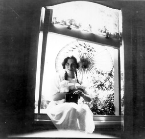
Photograph, Norma Bull portrait
Norma Bull in a window of 'Medlow', 1920s Her brother (Ronald) Richard was a keen photographer and is believed to have taken the photographs of the family and in the grounds of 'Medlow'. Norma Catherine Bull (7 September 1906 – September 1980) was an Australian painter, printmaker and etcher best known for the paintings and sketches she made in Britain during World War II. Norma was the daughter of Richard Joseph Bull (1874-1927) and Catherine Grace Perrier (1884-1972). Her father was the Director of Bacteriology at Melbourne University. Richard and Catherine had 2 children. Norma was born in Hawthorn in 1906 and her brother Ronald Richard was born in Surrey Hills in 1912, where in 1911 Richard bought a property at 42 Warrigal Road, Surrey Hills developed by Colonel William Cairncross, known as ‘Willcyrus’ and renamed ‘Medlow’ by the Bulls. As a child, Norma was a high achiever both intellectually and artistically. She was educated at Fintona, where she matriculated as Dux of the School and winner of an exhibition in French. She won a scholarship to attend the University of Melbourne where she studied French, Zoology, Philosophy, English and History, leading to a Bachelor of Arts in 1929. Following this she studied painting and drawing at the National Gallery Art School for seven years. Whilst most of the students of the 1930s were inspired by Modernism, Norma followed more traditional styles and became known for her etchings and realistic depiction of urban scenes. Her work was strongly influenced by the conservative nature of the National Gallery Art School under Bernard Hall, and she remained a traditionalist all her life. In 1938, she was awarded the Sir John Longstaff Scholarship in Fine Art. This enabled her to travel to England to study at the Royal Academy in London. She arrived in April 1939 and after the outbreak of war, she worked as a volunteer at a First Aid Clearing Station and applied to become a war artist. In 1941, she was given a sketching permit by the War Artists Advisory Committee to record bomb damage in the Bristol area. In 1947, an exhibition of her 205 wartime works entitled “Two Hemispheres”, opened at Australia House in London. Many were acquired for major collections in England including the Victoria and Albert Museum, the Imperial War Museum and the Royal Collection. The “Two Hemispheres” exhibition toured Australia in 1948 and for over twelve months she followed Wirth’s Circus around the country, painting aspects of circus life. From then on she lived at Medlow’, From 1960 she was secretary of the Fellowship of Australian Artists. She was a finalist in the Archibald Prize on 2 occasions and is remembered through a biennial Art Prize, ‘The Norma Bull Portraiture Scholarship’ which is administered by The Victorian Artist’s Society. She continued to paint landscapes and seascapes in her traditionalist style. She had holiday homes at Anglesea and Bright. After she died in September 1980, 31 of her works were bequeathed to Bright Art Gallery. A black and white photograph of a lady holding a sun umbrella and sitting in a window frame.miss norma bull, medlow, house names, warrigal road, surrey hills, mr ronald richard bull -
 Flagstaff Hill Maritime Museum and Village
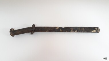
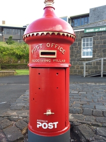
Functional object - Post Office Receiving Pillar, 1885
Post Office Receiving Pillar was Collected from Warrnambool City Council’s Scott Street Depot and transported to Flagstaff Hill, stored in the Barracks area Friends of Flagstaff Hill began the project of restoring the Post Office Receiving Pillar in early 2011. The replacement dome required a pattern to be made from paper, then timber, then someone to manufacture it. The cast iron body required sand blasting and undercoating. The pillar was installed in Flagstaff Hill Maritime Village in March 2014. A specialist visited the Village and painted the pillar with 7 coats of ‘post office red’ then completed the job with gold paint on the details. In 2015 an information plate of brass was fitted to the Pillar in the position that would have originally announced the clearing times. It was originally manufactured by G Couch, Engineer, Alliance Iron Works, Melbourne. Gordon Couch passed away in June 1896 and his Works were offered for auction in November 1897. HISTORY OF POST OFFICE RECEIVING PILLARS In 1851 ‘pillar boxes’ were installed at roadside locations in the island of Jersey, England; they had already been successful in several European countries. The use of new prepaid, adhesive postage stamps as well as the roadside pillar boxes meant there was no need for the public to take a trip to the Post Office just to post a letter. By 1855 London had installed its first six Pillar Boxes. In 1856 the pillar boxes were first introduced in Sydney. These were circular with a crown on the dome, supported by leaves. Early Victoria Mail was originally collected by ‘letter carriers’, first appointed in Melbourne in 1841, equipped with leather bag and hand bell. He wore a red coat with brass buttons and a black top hat! In 1844 two wooden receiving boxes were erected in Melbourne. The first cast iron boxes were installed in South Melbourne (Emerald Hill) and were still in service until 1967. They were a fluted circular design and made in England. In the early 1860’s the ‘low door round’ design posting box was introduced, being circular and surrounded by a crown, with two broad embossed bands around its circumference. The clearance door was in front of the box and low down. These were made in Australia. In the early 1870’s square boxes with a tapering top were being used. These too were made in Australia by different manufacturers with slight variations on style such as the orientation and number of slots. Next came the circular boxes again, similar to the ‘low door round’ but with the clearance door extending to just below the posting slot, often referred to as ‘high door round’. These boxes did not have embossed bands. In 1887 small cast iron boxes were introduced, attached to posts and poles and called ‘lamp post receivers’. Around 1930 a ‘London’ model was used in Victoria. It was copied from the flat-domed type in London but made in Tasmania. … [References: Flagstaff Hill Maritime Village records, The Argus, 11th April, 1890, The Argus, 2nd July, 1896, The Argus, 30th Nov. 1897, “Stamps.Au” http://www.stampsau.com, 4th April 2011 (Extracted from “Australian Street Posting Boxes” by Ken Sparks – out of print)] Post Office Receiving Pillar, or letterbox.1885 "High Door Round" design, restored 2014 Tall cast iron sylinder with decorative dome cap, slot in side, hinged door with handle shaped as a fist. Painted red with gold trip..Reconditioned barrel, reconstructed dome. Restored by Friends of Flagstaff Hill, 2014. Now a working letterbox. Made in Melbourne.Oval maker's plate “ - G. COUCH - / ENGINEER / ALLIANCE IRON / WORKS / MELBOURNE”flagstaff hill, warrnambool, shipwrecked coast, flagstaff hill maritime museum, maritime museum, shipwreck coast, flagstaff hill maritime village, great ocean road, post office receiving pillar, letterbox, mailbox, australia post -
 Eltham District Historical Society Inc
Photograph, Fay Bridge, Former Glynn's Dairy Farm, Glynns Road, North Warrandyte, 31 August 2018
Glynn’s farm Originally Section 7, Parish of Nillumbik marked Aborigine Reserve in 1866 Crown Allotment 8, Section 7, Parish of Nillumbik, County of Evelyn, Certificate of Title Volume 4095, Folio 818.835, approx. 93 acres purchased by Joseph Panton in 1881 for £1/acre and known as Panton’s Point. By 1924 owned by S.S. Sergeant and called Riverswood. Sergeant commissioned Edna Walling to design the garden. In September 1929 the property was sold at auction by Mortgagee’s sale. Described as well built, brick, tile roof, Attic Villa containing downstairs 7 good rooms, bath, scullery, inside lavatory, etc. Upstairs 2 bedrooms and sleep out. Outbuildings compromising of brick and weatherboard wash house, stables, workshop, feed room, cow bails, large G.I. Hay shed, etc In January 1931 Riverswood property was proclaimed a sanctuary for native game for the entire year. A private swing bridge crossed the river at Pound Bend was known as Pearson’s bridge after C.W.K. Pearson who bought Riverswood in the early 1930s. The bridge was swept away in the December 1934 floods. Riverswood was sold by C.W.K. Pearson at auction on 25 November 1936. Described as a beautiful farm home of 93 acres and over one mile of River Yarra frontage, modern brick residence, lovely garden, rich river flat pastures, model poultry farm. The fine brick home was destroyed on Black Friday (13 Jan.) 1939. It was still a ruin when the Evelyn Evans purchased Waikowhane above Riverswood in 1940. The Glynn family purchased the Riverswood property in 1941 from Robert and Emily Hannon. Their son Kenneth Patrick Glynn inherited the property and he set about clearing the land during WW2 selling wood. Prior to marriage, Kenneth was living alone on the farm in a house he had built from whatever was available. He used the bluestone foundations from the original fine brick home. He met and married Honora Elizabeth Drew in early 1945 and their daughter Anna grew up on the farm. It was compulsorily acquired by the Board of Works in 1976 who then rented the house out in the 1980s. The property was transferred to Melbourne Parks and Waterways in 1996. Waikowhane was a pretty timber house built on top of the hill on 50 acres above Riverswood by retired nurse Jessie MacBeth. (This would be at the intersection of Glynns Road and Overbank Road where the big water tank is now situated on what was once James Orford’s property.) It was also destroyed Black Friday and she rebuilt it from the plans living in a caravan on site supervising the build. It was almost complete when she died May 1939. The property was bought by Evelyn Evans (a city girl) and her estranged husband in 1940. She had two sons, one only 9 months old at the time. It was a timber house with no power or water connected. The Ewen Cameron family bought Waikowhane in 1957. They had to evacuate when the 1961 bushfires swept through. The house was saved by Matcham Skipper. It was demolished by Melbourne Water in the 1990s when they acquired it.fay bridge collection, 2018-08-31, glynn's, glynn's dairy farm, glynns road, north warrandyte, parks victoria, ruins, riverswood, kenneth patrick glynn -
 Flagstaff Hill Maritime Museum and Village
Functional object - Urinal, circa 1825
It is probable that the urinal was situated in the forward part of the ship rather than the stern, being one of two placed on either side of the deck and housed immediately adjacent to the doors into for-castle, or crew sleeping quarters. The toilets on maritime vessels were (and still are) called the ‘heads’, after the sanitation arrangements common until the end of the eighteenth century. The name was given to the ‘head’ of the ship, forward of the forecastle and around the beak or bowsprit. These first lavatories were floored with grating or nets so the force of the sea could wash them clean, and they were always used on the lee or non-weather side so the effluent fell directly into the water rather than back on board. The Children wrecking: The barque Children was one of the first vessels to be lost in the Western District the vessel was wrecked to the east of Warrnambool on 14th January 1838. When it ran ashore in hurricane-force winds, 22 passengers and crew were fortunate to escape being battered to death on the rocks. The Children broke up within 20 minutes, sweeping sixteen of those on board to their deaths. After eleven days, the survivors, all of whom were injured, were rescued and taken to Portland. According to Lloyd's Shipping Register 1837-1839, the Children was built in 1825 at Liverpool and operated by owners Gordon & Co, of London. Registration number 123/1837, James Henty then bought her in 1837 as a three-masted barque of 254 tons, with a hull of “part pitch pine, felt sheathed” and “coppered in 1837” at Launceston registered number 6/1837. In 1838 the Children, under her master Captain H. Browne, completed a successful round trip from Launceston to London (carrying wool and whale oil loaded in Portland), returning in late November of that year carrying a general cargo including house bricks used for ballast. On the 11th of January 1839, the Children sailed from Launceston for Adelaide, with 24 passengers, 14 crew, and an awkward mixed cargo, including 1500 sheep, 8 bullocks, 7 horses, and farming implements, and six whaleboats with associated whaling gear. One account states that when the Children were “put out from port she was light and badly ballasted”. The vessel immediately encountered four days of hurricane-force storms, eventually clearing on the early morning of the 14th. However, it was too late to take accurate measurements of the sun or stars to establish their position relative to the coast. The Children collided with a limestone stack at the entrance of Childers Cove, and the seas smashed her into pieces within half an hour. All the cargo and 16 lives were lost including 8 children. The Henty brothers contributed £150 towards a fund for the 22 survivors at a memorial service held in Launceston later that year. It was a major financial setback for James Henty and his brothers, but one from which they recovered. In a submission to the Governor of New South Wales dated 24 March 1840, the Henty’s summarised their work over the previous six years of establishing the Portland settlement stating. “Six stations have been occupied, one at Portland Bay three at the open country about 60 miles inland called ‘Merino Downs’ They have erected two houses at Portland Bay and two others at Merino Downs”.This urinal is significant as part of the vessels original fittings he Children was delivering cargo intended for the Portland Bay settlement of her owners the James Henty brothers The wreck is also significant as one of the first vessels to have been lost in the Western District of Warrnambool. As a result the shipwreck of the Children is registered with the Victorian Heritage Register S116. A lead urinal with a rounded back at the top splash plate with an attached semi-circular receptacle or basin (20cm deep and projecting forward 30cm). At the sides are flanges with bolt holes connecting to a ship's wall. The urinal is drained by a funnel-shaped outlet also made of lead, reducing from a 10cm radius to a joined 5 cm pipe. The urinal was recovered from the wreck of the CHILDREN.Noneflagstaff hill, warrnambool, flagstaff-hill, flagstaff-hill-maritime-museum, shipwreck-coast, shipwreck artefact, the children, lead ship’s plumbing, crew urinal, the ‘heads’, ship plumbing, james henty, portland bay, urinal, ship's urinal -
 Wodonga & District Historical Society Inc
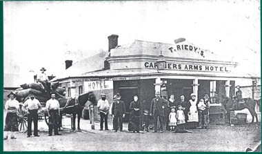
Photograph - The Carriers' Arms, Wodonga
In October 1874, Thomas Reidy and Andrew McCormack opened the Carriers’ Arms on the corner of South and Church Streets. They also established a general store next door, which they soon extended. The Carriers’ Arms was a coach stop for the Bethanga Express Coach. On 8 December 1882 the licence for the Carriers’ Arms was granted to Ann Reidy. In 1883, Edmund T. Powell, and his Irish-born wife, Mary Ann, purchased the Carriers’ Arms. By 1898 the Licence was in the name of M. A. Powell. She was still the licensee at the time of her death in August 1906. For a short time, the property was in the hands of Miss Maud Powell but in February 1907, the licence for The Carriers’ Arms Hotel was transferred to Mr George L. Leighton. On Monday 5th February 1917 a clearing sale of all furniture and effects of the Carriers’ Arms Hotel was held. The new proprietor and licensee was Henry R. Baker. In April 1920, the Carriers’ Arms had another new proprietor, Mrs A. E. Frauenfelder but by October 1921 it was transferred to Kathleen Hickey. Mrs. Hickey was at the Carriers’ Arms until she died in January 1926. In 1927, Mr H.W. Allen, formerly proprietor of the Terminus Hotel took over the Carriers’ Arms but in August 1928 the balance of the lease was transferred to Mrs Mulrooney. In 1932 it again changed hands, with the licence being transferred to Mrs Eileen Dorothy Hemphill, of Wodonga. In 1933 the Carriers’ Arms was licensed to Mrs. M.G. O’Brien, a sister of Mrs Hemphill. In 1935 Leo Houlihan took over the business but 6 months later it was transferred to A C Ferguson. The next year the licence was transferred yet again to Zelda Allen. By 1937 it was in the hands of Percy Cumberland then to Lila Maud MacPherson and soon followed by Ronald Dobson. By 1940 Herbert V.A. Callender had taken over the Carriers’ Arms and in 1942 the licence was transferred again to Sarah Jane Callander. In July 1943 Mr G. A. Adams disposed of the freehold of the Carriers’ Arms Hotel in Hume Street to Mr J.H. Perry. By September 1955 Edward Spencer held the Victualler’s licence for Carriers Arms Hotel and the licences was transferred to Kevin Patrick Howell. Mr Howell operated the hotel for many years. At some stage in the 1980s Geoff Milne operated the Carriers’ Arms. In 2007 he was killed in a light airplane crash. In 1991 David McLeish and Bob Craig, took over the Carriers’ Arms and were joined in 1993 by James Carroll. They continued to operate it until 2003. In 2010 Greg Evans held the Freehold with Licensees Cate Nightingale and Michael McNamara, After running into major financial difficulties it was run by Greg Evans. In 2010 the Carriers’ Arms was put up for auction but failed to sell. From 2013 - 2016, Ron Montgomery and his wife Michelle took over the lease of the Carriers’ Arms. In 2018, the Carriers’ Arms was purchased from Greg Evans by Leigh Esler. After opening to the public in 1874, The Carriers’ Arms was closed in 2019 and following extensive refurbishment opened as Church Street These items are significant as they document the history of a long-serving business in the Wodonga community.A collection of photos and advertisements documenting the life of the Carriers' Arms Hotel, Wodonga.early wodonga businesses, carriers' arms wodonga -
 Ringwood and District Historical Society
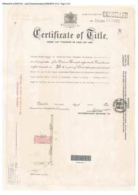
Document, Certificate of Title - W.G. Carter, Grandview Grove, Warranwood, Victoria, (later Bemboka Road) - part of Crown Section Twenty, Parish of Warrandyte, County of Evelyn - 1947
A4 copies of Landata Victoria Historical Search documents - Vol 7052 Fol 1410222. Includes Carter Family Tree property notes. William George Carter of Grandview Grove Ringwood, Nurseryman, is now the proprietor - three acres or thereabouts shown on map (12202a) - 14th March, 1947. Transfer B284834 Registered 21 September, 1961 - 1 acre shown on map (12202c) north of Plymouth Road. NOTES ON GRANDVIEW GROVE PROPERTY (Carter Family Tree extract) The Grandview Grove property was purchased by William (Bill) and Doreen Carter in 1947 as three acres of uncleared bushland. They had a 2 bedroom fibro-cement house built on the land which they informally called "Willoreen". With Doreen looking after sons Peter (born in 1940) and Robin (born in 1950), Bill worked locally at Croydon Dairy. The family spent much of their spare time clearing the land, where Bill then grew and sold fruit, flowers and berries, particularly strawberries, as a hobby and to supplement their income. Bill continued to do so while Peter and Robin were growing up, and after Doreen died in 1958. In 1961 Bill sold one of the three acres to one of his seven sisters, Grace, who lived in Kew but later moved to Rosebud and sold the land without ever building on it. During the 1960s, Grandview Grove was renamed Bemboka Road. After retiring as a milkman, Bill moved to Rosebud, Vic, and in 1977, sold the property to the Anglican Church, who were looking to invest in the site in anticipation of proposed future residential development in the area. As nearby properties were subdivided during the 1980s, the house, which the Church had initially utilised as low-cost family accommodation, was modified internaly to become a church/Sunday school. By the early 2000s, construction of a contemporary-design church and carparking area between the house and street alignment had been completed but the house remained as a detatched meeting room until falling into disrepair and was eventually demolished around 2010. -
 Melbourne Tram Museum
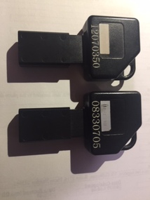
Functional object - Digital memory module, KDM, c1995
Digital Memory module, or Portable Memory Key, equivalent in type to a USB stick, black plastic with sliding mechanism to protect 8 copper contact strips with a digital memory area at one end. Stamped into the memory area part number "109 13858 512K KDM", indicating it had a memory storage of 512Kb. Above the number are the remains of a white bar-code label. Has as key type appearance. .1 - Numbered in white numerals "08330705" .2 - ditto "120703350" Advised by Adam Chandler 20-11-2017: They were used by tram and bus drivers. The PM (portable memory) key was issued to each driver. At the start of a shift, the driver would put it into a cream-coloured terminal at the sign-on point (starter's office in the depot) and transfer their shift information onto the key. Once the driver reached the vehicle, they put the key into the black-coloured terminal (tram driver's keypad - TDKP or bus driver's keypad) to upload the shift data to the vehicle. This was also the method used to transfer the 'blacklist' of periodical passes that had been stolen or misappropriated to each vehicle. IE if an annual Metcard had been stolen, once the holder reported it to Metcard they would blacklist the ticket number and this would be sent out to every depot and piece of equipment. From memory there were 100 slots in the blacklist. When a tram driver was finishing their shift (either being taken or running in) they would transfer all of the validations and ticket sale information to the PM key by inserting it a few minutes before the end of shift and downloading all of this data from the vehicle. They would then be required, on arriving back at the starter's office, to insert the key in the cream coloured terminal once more and copy all of the information across to the main system. Bus drivers also issued tickets from their BDKPs so the black PM key was also used for ensuring the accounting information was copied across to the main system. My memory might be faulty but I recall using them at railway stations with the Booking Office Machines (for starting and finishing shifts). No transfer of ticket issuance data however, as there was a computer equipment cabinet at each railway station with a DSL or cable link back to the OneLink central computers (in the revenue clearing house) I don't know what happened with the MTH cars on the Stony Point rail line but I could presume that there was a cabinet with a TDKP equivalent in it and a similar procedure for start and finish of shift.trams, tramways, ticket machines, metcard -
 Bendigo Historical Society Inc.
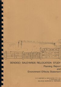
Book - BENDIGO SALEYARDS COLLECTION: BENDIGO SALEYARDS RELOCATION STUDY - PLANNING REPORT AND ENVIRONMENT
Bendigo Saleyards Relocation Study - Planning Report and Environment Effects Statement for the City of Bendigo by A E Huefner & Associates Pty Ltd in association with Meldrum Burrows & Partners. Book has a light brown cover with black plastic binder spine. Green and yellow pages separate some sections. The front cover has a sketch of a stock transport with a pig, sheep and cattle behind gates. Contents include: Introduction, Summary, Recapitulation on the Feasibility Report which includes The Need for Action, the Site and Existing Uses Adjacent to the Site, The Proposal which includes Concept, Project Description, Components, Siting of Facilities, Land Clearing, Earthworks, Darainage, Buildings and Structures, Roads and Pavements, Services, Landscaping, Soil Profile and Construction Programme. Invironmental Effects which include Visual Impact Dust, Odours, Effluent, Effluent Treatment System, Traffic, Artificial Lighting, Noise, Operational Failures and Nature Conservation Effects. Statutory Planning Considerations which includes Zoning Controls and Suggested Procedure for Initiating I.D.O. Amendment. Appendices are: A.- Copy of Tit;e, B - Soil Investigation, C - Acoustic Assessment and D - Suggested Draft Amendment to Shire of Marong I.D.O. Contains a photo of the area - View of the Site, looking South and a number of drawings. Copies of various Council Reports referring to the Saleyards Relocation Project. It has a bright yellow cover and a hard plastic type spine. Mentioned in the reports is the cost to bring the old saleyards up to standard and list of improvements. Reports are as at 16th July, 1984. Mustard coloured book with plastic spine titled Bendigo Saleyards Relocation Study Feasibility Report by Meldrum Burrows & Partners in association with A E Huefner & Associates Pty Ltd and Acil Australia Pty Ltd dated September, 1983. Items mentioned are: Introduction, Summary, Background, Role in Livestock Marketing for the Bendigo Saleyards (Acil Australia Pty. Ltd., Saleyard Relocation: Strategic Considerations, Financial Implications and Conclusion. Appendix 1: Estimation of Livestock Population in Catchment Area. Drawings in Fig 1 Existing Bendigo Saleyards and Surrounding Land Uses, Fig 2 Catchment Area for Bendigo Saleyards 1983, Fig 4.1 Estimated Sheep Populatiuon in Catchment Area 1976 - 77 to 1981 - 82, Fig 4.2 Estimated Cattle Population in Catchment area 1976 -77 to 1981 -82, Fig 3 Possible Saleyard Relocation Areas, Fig 4, Directions from which access to possible Saleyard Locations would be obtained - Estimated percentage of sheep to cattle stock, Fig 5 Possible Saleyard Locations - Northern Area, Fig 6 Possible Locations of Saleyards - Inner West, Fig 7 Possible Locations of Saleyards - Outer West. Considerations were made as to renovate the existing saleyards or to move them elsewhere. Effluent, transport and stock movement, and condition of the yards were a problem.bendigo, council, cattle markets, bendigo saleyards collection - bendigo saleyards relocation study - planning report and environment effects statement, a e huefner & associates pty ltd, meldrum burrows & partners, city of bendigo, state electricity commission, mal styles, bendigo college of advanced education, n j fieldew, pryce goodale & duncan pty ltd, p b swift, shire of marong -
 Federation University Historical Collection
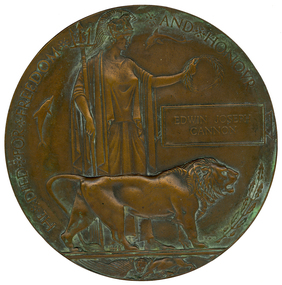
Medal - Numismatics, 'Dead Man's Penny' for Edwin Joseph 'Ted' Cannon, c1919
The Dead Man’s Penny is a commemorative medallion which was presented to the next-of-kin of the men and women from England and the Empire who died during World War One. The Dead Man’s Penny was accompanied by a letter from King George V, stating ‘I join with my grateful people in sending you this memorial of a brave life given for others in the Great War’.[http://nma.gov.au/blogs/education/2010/11/14/dead-mans-penny/] Popularly known as the "Dead Man’s Penny", because of the similarity in appearance to the somewhat smaller penny coin. 1,355,000 plaques were issued, which used a total of 450 tonnes of bronze, and continued to be issued into the 1930s to commemorate people who died as a consequence of the war. [http://en.wikipedia.org/wiki/Memorial_Plaque_(medallion)] It was decided that the design of the plaque was to be picked from submissions made in a public competition. Over 800 designs were submitted and the competition was won by the sculptor and medallist Edward Carter Preston with his design called Pyramus, receiving a first place prize of £250.[http://en.wikipedia.org/wiki/Memorial_Plaque_(medallion)] They were initially made at the Memorial Plaque Factory, 54/56 Church Road, Acton, W3, London from 1919. Early plaques did not have a number stamped on them but later ones have a number stamped behind the lion's back leg. [http://en.wikipedia.org/wiki/Memorial_Plaque_(medallion)] Ted Cannon's plaquette does not have a stamped number. Ted Cannon was a gifted artist and cartoonist who studied at the Ballarat School of Mines Technical Art School. During the Battle of Pozieres on the Western Front Ted Cannon worked with the Scout Platoon sketching the enemy's gun emplacements. Ted proved invaluable to the Brigade and brought he came under the attention of the Australian High Command. On 13 September 1916 Ted was given a special assignment for General C.B.B. White. Ted was sent out forward of the Old Mill at Verbrandenmolen (in the Ypres Salient) to draw a panorama of the German lines in the area from Hill 60 to The Bluff. It was a hazardous task and Ted was warned to be careful. Tragically he was sniped by an enemy machine-gunner and sustained severe abdominal wounds. Stretcher-bearers rushed him to the 17th Casualty Clearing Station where he was operated on by the doctors at 8.30 that night. With little chance of success, but ever resilient, Ted remained conscious almost to the end. He died early in the morning of the 14 September 1916. His body was buried in the large Military Cemetery at Lijssenthoek. The effects of the late Ted Cannon were returned to his parents. These were an autograph book, three brushes, prayer book, housewife, whistle, book, hymn book, curios. Another listing gives his effects as "identity disc, letters, photos, wallet, 2 books, Mexican Dollar, 1 cent (Ceylon), 3 German Straps, Fountain Pen, Cigarette-holder, Franc Note, 50 centimes Note, devotional book, mirror, rosary, scapula, metal ring, two combs, book of views, nail clippers, badges, tie clip, Egyptian stamp.[http://recordsearch.naa.gov.au/scripts/Imagine.asp?B=3202589] Ted Cannon was an only child. It is not known how the 'Dead Man's Penny' came into the ownership of the donor, but it is thought that it may have been left in a house owned by the donor's mother. Further information on Ted Cannon can be found at http://bih.ballarat.edu.au/index.php/Edwin_J._Cannon and http://www.ballarat.edu.au/about-ub/history/art-and-historical-collection/ub-honour-roll/c/edwin-joseph-ted-cannon-1895-1916Large bronze medallion or plaquette featuring an image of Lady Britannia surrounded by two dolphins (representing Britain’s sea power) and a lion (representing Britain) standing over a defeated eagle (symbolising Germany). Around the outer edge of the medallion are the words ‘He died for freedom and honour’. Next to Lady Britannia is the deceased solider’s name, with no rank provided to show equality in their sacrifice. (http://nma.gov.au/blogs/education/2010/11/14/dead-mans-penny) The plaque was distributed throughout the British Empire, and the first plaques were distributed in Australia in 1922 "Returned home" by W. & O. Mayne, 2013. ted cannon, edwin joseph cannon, cannon, world war 1, world war -
 Old Colonists' Association of Ballarat Inc.
Photograph - Photograph - Colour, The entrance foyer of the Old Colonists' Club, 2015
From the Argus Newspaper of 10 May 1888: "OLD COLONISTS' ASSOCIATION OF BALLARAT. (FROM OUR CORRESPONDENT.) BALLARAT, WEDNESDAY. This association, which was founded in August, 1883, and at first known as the Old Identities' Association, now has a roll of 450 members. The objects of the association are "to aid and assist indigent or suffering old colonists; to raise a fund, by the voluntary subscriptions of the members and the aid of outside donations, for the purpose of relieving members in sickness and old age ; for assisting those in extreme distress, to provide the shelter o a home for old and indigent pioneers of the gold fields, their widows, or anyone connected with the association, and in the event of the death of any member to have his remains decently buried, the association defraying the expenses of the funeral (providing that no funds or property are left by the deceased), and to attend the funeral if so desired by the relatives " The qualifications for member- ship are good character and repute, and residence in the colonies for a quarter of a century. For some time the association had no property except the regular subscriptions, but about a year ago they obtained from the Minister of Lands the grant of a very valuable block of land in Lydiard-street, the Crown grant of which they received last week. This block has a frontage of 66ft to Lydiard street, worth at least £100 a foot. The ground was given to the association as a site for them to build a hall upon, and with so valuable an asset they had no difficulty in borrowing at 7 per cent, enough money to construct a hall. For revenue purposes the ground floor of the building has been made into four shops, and the rental from these, judging from the rentals of shops in the vicinity, will not only pay all the interest on the borrowed money, but over £200 a year towards clearing off the principal. The officers of the association are Messrs J P Murray, president; J W Graham and T. Stoddart, vice presidents; D Fern, treasurer , and J Fraser, secretary. The Old Colonists' Hall is an elegant looking building in Lydiard-street, lying between the newly-opened mining exchange and the Commercial Club house, and a few doors north of the Post office. The style of the facade is classic. The lower portion of the front is constructed of Waurn Ponds stone, forming piers, and the upper portion of brick and cement, the background being tuckpointed. The centre bay is carried by two three quarter columns with Ionic cups, which support a pediment on which is set a cast of the Ballarat coat of arms. The four other bays are supported by pilasters with Corinthian caps mid partly fluted. The entrance is through a spacious circular headed doorway, the keystone of the arch of which bears a sculptured head, in marble, representing that of the president of the Old Colonists' Association here, Mr. John P Murray. An ample vestibule leads to a wide stone staircase which ends at a spacious landing. The landing has a dome over the centre, with cornice and enrichments, and is lighted from above. The walls round the landing are panelled with marble slabs, which are to be appropriately inscribed in the future. On the first door are the rooms appropriated to the association. The principal of these is a hall 44ft x 33ft and 17ft high. This room is well ventilated and lighted from the back of the building with large windows, and the walls are finished with Keene's cement. The other rooms are committee room, 14ft x 16ft; scretary's, 14ft x 17ft 6in; kitchen, bedrooms, bathroom, &c. The front portion of the first floor is arranged so that it may be let for offices, or utilised for club purposes. Suitable provision has been made throughout tor lighting, ventilation, and means of egress. The architect for the edifice is Mr A. G Legge, of this city, and the contractors are Messrs. Whitelaw and Atkinson, Irving and Glover, Reynolds, and J Donaldson. The total cost of the building when completed, which will be in a few weeks, will be about £4,000."Colour photograph of a room with marble plaques on the wall. They relate to the Old Colonists' Association of Ballarat, old colonists' association ballarat, old colonists' club, marbles -
 Halls Gap & Grampians Historical Society
Map - Coloured
Background on Bridle Path up Stony Creek Gorge Pre 1840 C. B. Hall, squatter on Mokepilly Run 1841-1842, first European to discover the Fyans Creek valley, the entrance of which became known as Hall's Gap. He later recorded that he followed a number of tracks which he assumed had been made by the Aboriginies and described one as "leading up a wild romantic glen and over on to the source of the Glenelg River". This could well have been the route taken up Stony Creek gorge by the first timber-cutters in this part of the Grampians to the saddle between the Wonderland and Mt. Difficult ranges known as Valley Gap 1850s/60s Timber cutters and shingle splitters were reported to be moving into the eastern side of the Grampians and by the mid 1860s there were a number of families connected to the supplying of timber to Pleasant Creek living in the "Hall's Gap ranges". John Wakeham, the first store owner in Pleasant Creek in 1854, established a timer-mill in upper Stony Creek Gorge in the late 1850s. Wakeham is credited for the clearing and levelling of the first bridle-path up the gorge. 1870s By the mid 1870s the track had been extended over Valley Gap to the Victoria Forest (the upper region of the Victoria Valley). McKeon's bullock team was known to have hauled red gum from the Valley to Stawell in the late 1870s and the 1880s. 1880s In 1887 an article in the Pleasant Creek news describes the Stony Creek Gorge track as "being a ledge alongside the mountain range, formed in the early days with the aid of earth and timber, along which the bullock teams used to travel to Horsham and plains of the Wimmera beyond." 1890s Gold was discovered in the catchment area of Stony Creek and by the end of the 1890s a new track was built from "near the junction of Fyan's and Stony Creeks, up the gorge to the diggings settlement. The mining Department had paid L300 for its construction and, when completed, the track was "three miles and 30 chains in length, the side cuttings at the narrowest part being 10 feet between" and "the watercourses which cross the track at various points" having been "filled up with rocks rolled down the sides of the hills, and consequently there can be no damage caused by bushfires which destroyed the former wooden bridges erected on the old track to Wakeham's saw-mill, the remains of which are still to be seen at the side of the diggings" The article goes on to further describe the track as one which "can with ease travel with a two horse conveyance either up or down" and that the workmen engaged in the construction of the track would be attending "a ball that night at McKeon's farm near the mouth of the gap to celebrate the successful completion of the undertaking". 1900s At what time the bridle path was extended beyond Valley Gap to the Wartook basin on the Mt. Difficult Range has not yet been determined. However, it is known that, by the turn of the century, people were travelling between Halls Gap and the caretakers' residence at Wartook Reservoir along what was now known as the "Bluff Road. Wartook's embankment had been constructed in 1887 and at that time there was already a track from Rosebrook Station homestead (near the present day Wartook Pottery) to the reservoir. Philip Rose owned both Rosebrook and Wartook Stations from the mid 1840s to the late 1850s and had regularly leased the Wartook basin to Cobb & Co. to rest horses there. 1920s Following the war of 1914-1918, tourism really took off in the Grampians, and Halls Gap rapidly grew. People would travel as far as they could on the many tracks then hike to the many lookouts being discovered by local tour guides. This led to the need for access across the range so that horse riders and the increasing number of vehicles could travel between Horsham and Halls Gap. To this end, the Bluff Road was improved and extended on 1929 and at its opening in March, 1930, by Lady Somers it was renamed the Mt. Victory Road.Map of Mt Victory Road and othersaccess routes, mt victory rd, bridle path, roads -
 Eltham District Historical Society Inc
Photograph - Digital Photograph, Alan King, Kinglake National Park, 27 March 2008
Fern gullies around Jehosaphat Gully Covered under National Estate. Published: Nillumbik Now and Then / Marguerite Marshall 2008; photographs Alan King with Marguerite Marshall.; p125 The magnificent Kinglake National Park, fringing Nillumbik’s north, is the largest national park close to Melbourne. Thanks to the vision and hard work of a band of local people, the park was created from what was rapidly becoming degraded land. Seeing a threat to Kinglake’s indigenous flora and fauna, several prominent local people campaigned for a national park, which was established in 1928.1 Since then, the park has grown through donations and acquisitions of land, from around 13,800 acres of land (5585ha) to 22,360 hectares. The Sugarloaf and Everard Blocks – of almost 8000 hectares – stand in Nillumbik and the park extends into Mitchell and Murrundindi Shires and the City of Whittlesea. Mt Everard commemorates William Hugh Everard, State member for Evelyn when the park was established. Before 1928, European settlers had degraded the Kinglake area, which was named after the celebrated English author and lawyer, Alexander William Kinglake. Remains of gold shafts and diggings in the park are reminders of Kinglake’s first settlers, who hoped to strike it rich at the gold diggings. But like other gold fields in this shire, they proved not very lucrative and soon timber cutting replaced mining in importance. However, before long, the accessible timber supply ran out, so in the 1920s agriculture took over – particularly potatoes and berry fruits – which involved large-scale clearing.2 The park’s instigator was retired Melbourne University Professor of Music, William Laver.3 As chair of the Kinglake Progress Association he began negotiations to have crown lands on the southern scarp of the Great Dividing Range reserved as a national park. Even before the park was proclaimed, from 1927, KPA members cut tracks to the major scenic points. Professor Laver was one of several people who gave land for the park, donating around 50 acres (20ha), including the Jehosaphat Gully.4 Laver chaired the park’s first Committee of Management, which raised money to employ a ranger and provide facilities, including tracks and roads for fire protection vehicles, toilets and shelters. The committee charged fees for firewood collection, some grazing of livestock, and visitor entrance, and obtained small State Government and Eltham Shire grants. In 1957 the State Government provided revenue for national parks. Then, in 1975, the State Government took over the management and the Committee of Management became an advisory committee, which disbanded in 1978. Originally, the park covered crown land in the Shires of Eltham and Whittlesea; then Wombelano Falls in Yea and other areas were added. In 1970 the park extended into the Shires of Eltham, Healesville, Whittlesea and Yea.5 Bush fires have been an ongoing problem. In 1939 hundreds of eucalypts and acacias had to be sown around the Jehosaphat Gully to rejuvenate the forest. To manage bushfires, the Committee of Management, then the State Government, worked closely with the Forestry Commission, shire councils and local fire brigades. Early national parks focussed on recreation. But by the 1980s, conservation, education and scientific research became more important, playing a vital role in preserving representative samples of the natural environment. Each year many thousands of people use the park’s extensive network of walking tracks amongst the protected plant and animal life as well as camping, cycling and horse riding. The park, along the slopes of the Great Dividing Range, has lookouts revealing magnificent views of the Melbourne skyline, Port Phillip Bay, the Yarra Valley and the You Yangs. Vegetation in the Masons Falls area includes messmate forest, Austral grass-trees, ferns and Hazel Pomaderris. In spring, orchids, lilies, everlasting daisies, correas, grevillea and heath appear. Around Jehosaphat Gully are wet and dry forest, fern gullies and banksia. Animal life includes wallabies, kangaroos, koalas, echidnas, possums, gliders and bandicoots. Male lyrebirds can be heard mimicking in the Jehosaphat Gully, particularly in the Everard Block in winter.This collection of almost 130 photos about places and people within the Shire of Nillumbik, an urban and rural municipality in Melbourne's north, contributes to an understanding of the history of the Shire. Published in 2008 immediately prior to the Black Saturday bushfires of February 7, 2009, it documents sites that were impacted, and in some cases destroyed by the fires. It includes photographs taken especially for the publication, creating a unique time capsule representing the Shire in the early 21st century. It remains the most recent comprehenesive publication devoted to the Shire's history connecting local residents to the past. nillumbik now and then (marshall-king) collection, kinglake national park, jehosaphat gully -
 Eltham District Historical Society Inc
Photograph - Digital Photograph, Alan King, Blue Lake, Plenty Gorge Park, 2008
A quarry was transformed into the Blue Lake. Published: Nillumbik Now and Then / Marguerite Marshall 2008; photographs Alan King with Marguerite Marshall.; p179 The dramatic steep-sided Plenty Gorge lies along the divide of two geological areas, and separates the Nillumbik Shire and the City of Whittlesea. On the Nillumbik side are undulating hills and sedimentary rock, and in Whittlesea, lies a basalt plain formed by volcanic action up to two million years ago. This provides the Plenty Gorge Park with diverse vegetation and habitats, making it one of Greater Melbourne’s most important refuges for threatened and significant species. The park, established in 1986, consists of around 1350 hectares, and extends 11 kilometres along the Plenty River, from Greensborough to Mernda. It provides a wildlife corridor for around 500 native plant and 280 animal species. The area’s plentiful food and water attracted the Wurundjeri Aboriginal people and then European settlers. By 1837 squatters had claimed large runs of land for their sheep and cattle. The Plenty Valley was among the first in the Port Phillip District to be settled - mainly in the less heavily timbered west - and was proclaimed a settled district in 1841.But by the late 1880s, the settlers’ extensive land clearing for animal grazing, then agriculture, depleted the Wurundjeri’s traditional food sources, which helped to drive them away. Many Wurundjeri artefacts remain (now government protected), and so far 57 sites have been identified in the park, including scarred trees, burial areas and stone artefacts. Pioneer life could be very hard because of isolation, flooding, bushfires and bushrangers. Following the Black Thursday bushfires of 1851, basalt was quarried to build more fire-resistant homes. Gold discoveries in the early 1850s swelled the population, particularly around Smugglers Gully; but food production made more of an impact. In the late 1850s wheat production supplanted grazing. In the 1860s the government made small holdings available to poorer settlers. These had the greatest effect on the district, particularly in Doreen and Yarrambat, where orchards were established from the 1880s to 1914. Links with a prominent early family are the remains of Stuchbery Farm, by the river’s edge bounded by Smugglers Gully to the north and La Trobe Road, Yarrambat, to the east. The Stuchberys moved to the valley in 1890, and the family still lives in the area. In 1890, Alfred and Ada first lived in a tent where four children were born, then Alfred built the house and outbuildings around 1896. They planted an orchard, then a market garden, and developed a dairy. The family belonged to the local Methodist and tennis communities. Their grandson Walter, opened the Flying Scotsman Model Railway Museum in Yarrambat, which his widow, Vi, continues to run. Wal was also the Yarrambat CFA Captain for 22 years until 1987. Walter sold 24 hectares in 1976 for development - now Vista Court - and in 1990, the remaining 22.6 hectares for the park. Remaining are an early stone dairy and remnants of a stone barn, a pig sty and a well. Until it was destroyed by fire in 2003, a slab hut stood on the Happy Hollow Farm site, at the southern end of the park. The hut is thought to have been built in the Depression around 1893. This was a rare and late example of a slab hut with a domestic orchard close to Melbourne. Emmet Watmough and his family first occupied the hut, followed by a succession of families, until the Bell family bought it around 1948. There they led a subsistence lifestyle for 50 years, despite encroaching Melbourne suburbia. The Yellow Gum Recreation Area includes the Blue Lake, coloured turquoise at certain times of the year. Following the 1957 bushfires, this area was quarried by Reid Quarries Pty Ltd for Melbourne’s first skyscrapers, then by Boral Australia. However in the early 1970s water began seeping into the quarry forming the Blue Lake and the quarry was closed. The State Government bought the site in 1997 and opened it as a park in 1999.This collection of almost 130 photos about places and people within the Shire of Nillumbik, an urban and rural municipality in Melbourne's north, contributes to an understanding of the history of the Shire. Published in 2008 immediately prior to the Black Saturday bushfires of February 7, 2009, it documents sites that were impacted, and in some cases destroyed by the fires. It includes photographs taken especially for the publication, creating a unique time capsule representing the Shire in the early 21st century. It remains the most recent comprehenesive publication devoted to the Shire's history connecting local residents to the past. nillumbik now and then (marshall-king) collection, blue lake, plenty gorge park -
 Eltham District Historical Society Inc
Photograph - Digital Photograph, Marguerite Marshall, Stuchbery Farm dairy, 14 March 2008
Stuchbery Farm was situated on the Plenty River bounded by Smugglers Gully to the north and La trobe Road, Yarrambat, to the east. Alan and Ada Stutchbery moved to the valley in 1890, first living in a tent where four children were born. Alfred built a home and outbuildings around 1896. They planted an orchard, then a market garden and developed a dairy. Published: Nillumbik Now and Then / Marguerite Marshall 2008; photographs Alan King with Marguerite Marshall.; p179 The dramatic steep-sided Plenty Gorge lies along the divide of two geological areas, and separates the Nillumbik Shire and the City of Whittlesea. On the Nillumbik side are undulating hills and sedimentary rock, and in Whittlesea, lies a basalt plain formed by volcanic action up to two million years ago. This provides the Plenty Gorge Park with diverse vegetation and habitats, making it one of Greater Melbourne’s most important refuges for threatened and significant species. The park, established in 1986, consists of around 1350 hectares, and extends 11 kilometres along the Plenty River, from Greensborough to Mernda. It provides a wildlife corridor for around 500 native plant and 280 animal species. The area’s plentiful food and water attracted the Wurundjeri Aboriginal people and then European settlers. By 1837 squatters had claimed large runs of land for their sheep and cattle. The Plenty Valley was among the first in the Port Phillip District to be settled - mainly in the less heavily timbered west - and was proclaimed a settled district in 1841. But by the late 1880s, the settlers’ extensive land clearing for animal grazing, then agriculture, depleted the Wurundjeri’s traditional food sources, which helped to drive them away. Many Wurundjeri artefacts remain (now government protected), and so far 57 sites have been identified in the park, including scarred trees, burial areas and stone artefacts. Pioneer life could be very hard because of isolation, flooding, bushfires and bushrangers. Following the Black Thursday bushfires of 1851, basalt was quarried to build more fire-resistant homes. Gold discoveries in the early 1850s swelled the population, particularly around Smugglers Gully; but food production made more of an impact. In the late 1850s wheat production supplanted grazing. In the 1860s the government made small holdings available to poorer settlers. These had the greatest effect on the district, particularly in Doreen and Yarrambat, where orchards were established from the 1880s to 1914. Links with a prominent early family are the remains of Stuchbery Farm, by the river’s edge bounded by Smugglers Gully to the north and La Trobe Road, Yarrambat, to the east. The Stuchberys moved to the valley in 1890, and the family still lives in the area. In 1890, Alfred and Ada first lived in a tent where four children were born, then Alfred built the house and outbuildings around 1896. They planted an orchard, then a market garden, and developed a dairy. The family belonged to the local Methodist and tennis communities. Their grandson Walter, opened the Flying Scotsman Model Railway Museum in Yarrambat, which his widow, Vi, continues to run. Wal was also the Yarrambat CFA Captain for 22 years until 1987. Walter sold 24 hectares in 1976 for development - now Vista Court - and in 1990, the remaining 22.6 hectares for the park. Remaining are an early stone dairy and remnants of a stone barn, a pig sty and a well. Until it was destroyed by fire in 2003, a slab hut stood on the Happy Hollow Farm site, at the southern end of the park. The hut is thought to have been built in the Depression around 1893. This was a rare and late example of a slab hut with a domestic orchard close to Melbourne. Emmet Watmough and his family first occupied the hut, followed by a succession of families, until the Bell family bought it around 1948. There they led a subsistence lifestyle for 50 years, despite encroaching Melbourne suburbia. The Yellow Gum Recreation Area includes the Blue Lake, coloured turquoise at certain times of the year. Following the 1957 bushfires, this area was quarried by Reid Quarries Pty Ltd for Melbourne’s first skyscrapers, then by Boral Australia. However in the early 1970s water began seeping into the quarry forming the Blue Lake and the quarry was closed. The State Government bought the site in 1997 and opened it as a park in 1999.This collection of almost 130 photos about places and people within the Shire of Nillumbik, an urban and rural municipality in Melbourne's north, contributes to an understanding of the history of the Shire. Published in 2008 immediately prior to the Black Saturday bushfires of February 7, 2009, it documents sites that were impacted, and in some cases destroyed by the fires. It includes photographs taken especially for the publication, creating a unique time capsule representing the Shire in the early 21st century. It remains the most recent comprehenesive publication devoted to the Shire's history connecting local residents to the past. nillumbik now and then (marshall-king) collection, ada stuchbery, alan stuchbery, dairy, stuchbery farm, farm buildings, yarrambat, plenty gorge park -
 Melbourne Legacy
Document, Diary of Priscilla Wardle, a nurse in France 1916, 1916
An incomplete diary of an Australian nurse serving in France in 1916. The author is unidentified in the document but after extensive research it is concluded that is by Priscilla Wardle, who left Melbourne on 14 April 1915 on RMS Orontes and served with Queen Alexandra's Imperial Military Nursing Service (QAIMNS) in France. A larger portion of her diary is available from the Ballarat Base Hospital Trained Nurses League entries on Victorian Collections. The contents of the diary has been retyped and is in the Word document. The diary shows she was serving at a Casualty Clearing Station (CCS) in Bethune, France in March 1916. She goes on to serve at Wimereux, at the No 8 Stationary hospital. Also possibly at Boulogne. She had a period of rest at Hardelot, a convalescent home for nurses, and also a trip to England and Scotland. She tried to visit the graves of ancestors, such as relatives of 'Grandfather Allan', in the church yard at East Kilbride church. During her nursing experience she mentions being gassed by 'weeping' gas and hearing the sounds of shelling. Also the numbers of operations per month, such as 311 in March 1916. And another day when there were 29 operations in one day. She talks of POWs coming to the hospital. They are treated after the Allied soldiers are looked after. So operations often continued into the night to take care of the Germans. She also mentions removing a piece of shrapnel herself in one operation. She appears to be of a senior rank as she is asked to meet with senior hospital officials and high ranking officers that visit. In particular she mentions a staff surgeon from Admiral Jellicoe's ship the 'Iron Duke'. He visited just after the Battle of Jutland, which was a naval battle fought between Britain's Royal Navy Grand Fleet, under Admiral Sir John Jellicoe, and the Imperial German Navy's High Seas Fleet, under Vice-Admiral Reinhard Scheer, during the First World War (31 May – 1 June 1916). Also being visited by Stan Walker (also from Ballarat) and Lt Brough who was ADC to General Legge. It is possible Stan Walker is Lt (later Captain) Edward Stanley Walker. Lt Brough is believed to be Charles Anthony Brough. She also mentions meeting a Lady Gifford and Madam O'Gorman. She mentions travelling with Captain Newton to London in early December 1916 - she calls him Sauchiehall and Sauchie, both could be nicknames. Capt Newton later becomes Sir Wilberforce Newton, who was serving in the Royal Army Medical Corps on the Western Front between 1915 and 1917. His diaries are held in the University of Melbourne archive. He also left Melbourne on the RMS Orontes on 14 April 1915 (source Trove) and would have known the 14 Victorian nurses that went on to serve with QAIMNS. On 11 December 1915 he mentions trying to see a Sister Loughran at the No. 7 Stationary hospital - which was in Boulogne. Sister Loughran was also on the RMS Orontes. When he was ill he mentions receiving a parcel from two other nurses that were on the Orontes and served with QAIMNS (Madge Donnellan and Margaret Donaldson). Other things that indicate it might be Priscilla Wardle is that from Births Deaths and Marriages Victoria (BDM) she was born in Ballarat, her mother's maiden name was Allan, she had a sister Janet that went by the name of Jean who was married at the time mentioned in the diary (BDM and Trove), Priscilla's mother also died during the time of diary and coincides with the diary entry of the 'death of dear mother'. An article in Trove after Priscilla's return to Australia mentions she was in the areas mentioned in the diary. Also that Priscilla went on to be trained as an anaesthetist to help in the surgeries. It matches the comment in the diary that she was involved in many operations and even allowed to perform a bullet extraction. Finally on seeing the diary held by Ballarat Base Hospital Trained Nurses League - it was determined the handwriting matched and this diary is part of the larger diary held there, so is definitely Priscilla Wardle. After the war Priscilla Wardle married Cyril Terrence (Terry) Charles Kirby, an English soldier and they settled in Ballarat and later Melbourne. Terry Kirby became a Legatee in 1929 and transferred to Melbourne Legacy in 1935. He was a well liked, hard working Legatee and worked at Legacy House up to his death in 1967. That is probably how the diary ended up in the building. In May 2021 the pages were returned to descendants of Priscilla so now only electronic copies are in our archive.A valuable first hand account of life as a nurse in World War One. The founders of Legacy all served in World War One and may have known this nurse or been in situations similar to her.Handwritten diary of a nurse from 1916 on 10 pages of notepaper.memoir, world war one, nurse -
 Eltham District Historical Society Inc
Film - Video (DVD), Frank Stokes, Stokes Family, 1950-1977
Various family scenes taken from outside the family home on the southeast corner of the intersection of Nyora Road and Pitt Street with Eucalyptus Road. Also, scenes of the Stokes Orchard and equipment used, construction of water reservoir at the end of Nyora Road near Reynolds Road and Diosma Road as well as early stages of the Stokes Orchard housing development. Frank Stokes worked as a qualified accountant at Kennons leather factory in Burnley, while living at 1 Thomas Street, Mitcham. He suffered from migraines and wanted to go back to the land (he had previously worked on farms and orchards since coming to Australia in 1926 both in WA and Vic.). He first travelled to the district by train in July 1942 to find land with the intention to establish an orchard. By chance he met Arthur Bird of Bird Orchard (bounded by Pitt Street, Eucalyptus Road and Wattle Grove) and they got talking over their common interest. Arthur put Frank up for the night and pointed out the land, 158 acres- Taylor Estate- £900, part of Crown Allotment 15, Section 5, Parish of Nillumbik (CA15) somewhat diagonally opposite Bird Orchard. He applied through the Riverina Agency to purchase the land who in turn had to get permission from Canberra to sell as there was a new government regulation banning land sales except for immediate production. He obtained a loan on his Mitcham house of £600 @ 5% and paid £450 deposit with quarterly payments of £15 over 5 years. The title to the property was issued May 15, 1946. He was helped and advised by Arthur Bird who farmed the neighbouring orchard. Early 1943 he took possession and would catch the train out to Eltham on Fridays after work and began building a hut for shelter and to lock up tools. He was able to pay a neighbour (Hawkins) to help with clearing and fencing 25 acres and with a horse and single furrowed plow, planted approximately 2,500 fruit trees - cherries, peaches, plums, almonds, pears, apricots and lemons as well as a few apples and oranges; a massive job. A huge problem was hares and rabbits eating all the new buds off the tiny trees. As well as laying poison he painted the trees with a mixture of cow manure and lime. Often working by moonlight. It was extremely difficult to get wire and wire netting because of the war but after much effort he obtained a permit from the Agricultural Department for supplies in March 1944. In February 1945 he applied for a permit to build a “packing shed” as no house building allowed. It was to be 33 feet x 21 feet and cost £312. Constructed mostly from second-hand materials, which was hard to obtain, especially iron for roofing. Frank finished work at Kennons October 31, 1945, and in March 1946 he sold the Mitcham house for £1230 plus £170 for furniture. The family of five then moved into a very unfinished at Eltham, which was a struggle to weatherproof. Eventually rooms were divided off and lined with hessian bags and whitewashed. Their income was firewood (cut and sold), selling rockery stones and cut sweet bursaria. (It was discovered during the 1940s that Bursaria contained the sunscreen compound Aesculin. The RAAF utilised this compound from Bursaria during WW2 for pilots and gunners.) The orchard’s first fruit sale was a 1/2 case of Le Vanq peaches in December 1947 - 8 shillings. In 1956 plans for house were drawn and Glen Iris bricks purchased (1956 Olympic Rings variant). The building of the house commenced in 1957 - 12 feet of original packing shed removed – and was completed in 1959. Water was connected from newly built pressure storage on the property at the end of 1959 and the electricity connection for the first time at 3pm on April 29, 1960. In the mid-1970s the Shire of Eltham divided the orchard up into numerous rate-able parcel lots, which became unaffordable for Frank. Consequently, Stokes Orchard was turned into a housing development by Macquarie Builders and marketed as the Stokes Orchard Estate in two stages; Stage 1 encompassing Scarlet Ash Court, Ironbark Close and Peppermint Grove bounded by Nyora and Eucalyptus roads c.1976 and Stage 2 encompassing Stokes Place, Orchard Way, The Crest and The Lookout bound by Nyora and Diosma roads c.1979. The development of Orchard Way, The Crest and The Lookout did not proceed as planned due to the lack of the sewer along Diosma Road and so many of the proposed lots were incorporated into five-acre parcels instead. With the arrival of the sewer along Diosma Road many years later, most of these five-acre parcels have since been subdivided many times.Representative of the orchard growing areas of ElthamMP4 00:24:39; 426MB Digital file only - Digitised by EDHS from a DVD copy on loan from Beryl Bradbury (nee Stokes), daughter of Frank Stokes. 24 min duration compilation of home movie Super 8mm film shot by Frank Stokes brother-in-law.beryl bradbury (nee stokes) collection, frank stokes, nyora road, stokes orchard, stokes orchard estate, stokes place, video recording -
 Ballarat Heritage Services
Digital photograph, Dorothy Wickham, Tower of London, 2016
The Tower of London, officially Her Majesty's Royal Palace and Fortress of the Tower of London, is a historic castle located on the north bank of the River Thames in central London. It lies within the London Borough of Tower Hamlets, separated from the eastern edge of the square mile of the City of London by the open space known as Tower Hill. It was founded towards the end of 1066 as part of the Norman Conquest of England. The White Tower, which gives the entire castle its name, was built by William the Conqueror in 1078, and was a resented symbol of oppression, inflicted upon London by the new ruling elite. The castle was used as a prison from 1100 (Ranulf Flambard) until 1952 (Kray twins),[3] although that was not its primary purpose. A grand palace early in its history, it served as a royal residence. As a whole, the Tower is a complex of several buildings set within two concentric rings of defensive walls and a moat. There were several phases of expansion, mainly under Kings Richard the Lionheart, Henry III, and Edward I in the 12th and 13th centuries. The general layout established by the late 13th century remains despite later activity on the site. The Tower of London has played a prominent role in English history. It was besieged several times, and controlling it has been important to controlling the country. The Tower has served variously as an armoury, a treasury, a menagerie, the home of the Royal Mint, a public record office, and the home of the Crown Jewels of England. From the early 14th century until the reign of Charles II, a procession would be led from the Tower to Westminster Abbey on the coronation of a monarch. In the absence of the monarch, the Constable of the Tower is in charge of the castle. This was a powerful and trusted position in the medieval period. In the late 15th century the castle was the prison of the Princes in the Tower. Under the Tudors, the Tower became used less as a royal residence, and despite attempts to refortify and repair the castle its defences lagged behind developments to deal with artillery. The peak period of the castle's use as a prison was the 16th and 17th centuries, when many figures who had fallen into disgrace, such as Elizabeth I before she became queen, Sir Walter Raleigh, and Elizabeth Throckmorton were held within its walls. This use has led to the phrase "sent to the Tower". Despite its enduring reputation as a place of torture and death, popularised by 16th-century religious propagandists and 19th-century writers, only seven people were executed within the Tower before the World Wars of the 20th century. Executions were more commonly held on the notorious Tower Hill to the north of the castle, with 112 occurring there over a 400-year period. In the latter half of the 19th century, institutions such as the Royal Mint moved out of the castle to other locations, leaving many buildings empty. Anthony Salvin and John Taylor took the opportunity to restore the Tower to what was felt to be its medieval appearance, clearing out many of the vacant post-medieval structures. In the First and Second World Wars, the Tower was again used as a prison, and witnessed the executions of 12 men for espionage. After the Second World War, damage caused during the Blitz was repaired, and the castle reopened to the public. Today the Tower of London is one of the country's most popular tourist attractions. Under the ceremonial charge of the Constable of the Tower, it is cared for by the charity Historic Royal Palaces and is protected as a World Heritage Site.(Wikipedia) A World Heritage Site is a landmark which has been officially recognized by the United Nations, specifically by UNESCO. Sites are selected on the basis of having cultural, historical, scientific or some other form of significance, and they are legally protected by international treaties. UNESCO regards these sites as being important to the collective interests of humanity. More specifically, a World Heritage Site is an already classified landmark on the earth, which by way of being unique in some respect as a geographically and historically identifiable piece is of special cultural or physical significance (such as either due to hosting an ancient ruins or some historical structure, building, city, complex, desert, forest, island, lake, monument, or mountain) and symbolizes a remarkable footprint of extreme human endeavour often coupled with some act of indisputable accomplishment of humanity which then serves as a surviving evidence of its intellectual existence on the planet. And with an ignoble intent of its practical conservation for posterity, but which otherwise could be subject to inherent risk of endangerment from human or animal trespassing, owing to unmonitored/uncontrolled/unrestricted nature of access or threat by natural or accelerated extinction owing to local administrative negligence, hence it would have been listed and demarcated by the United Nations Educational, Scientific and Cultural Organization (UNESCO) to have been identified or recognised and officially christened and internationally elevated through multilateral declaration by UNESCO as a universally protected zone. [1] The list is maintained by the international World Heritage Programme administered by the UNESCO World Heritage Committee, composed of 21 UNESCO member states which are elected by the General Assembly. (Wikipedia)The Tower of London is a UNESCO world heritage site.tower of london -
 Eltham District Historical Society Inc
Photograph - Digital Photograph, Alan King, Edendale Farm Homestead, 29 January 2008
Edendale Farm is Nillumbik Shire Council's environment centre situated in Gastons Road, Eltham between the railway and the Diamond Creek. The homestead on the property was built in 1896 and is of historical significance, being the subject of a Heritage Overlay under the Nillumbik Planning Scheme. The Edendale property was originally part of an extensive land purchase in 1852 from the Crown by pioneer Eltham farmer Henry Stooke. He initially purchased 51 acres and later expanded his holdings by purchasing another three adjacent Crown allotments extending northerly from Josiah Holloway's Little Eltham subdivision. Despite clearing the land, Stooke did not build on this property, choosing to live on his property "Rosehill" at Lower Plenty. In 1896 Thomas Cool, Club Manager of the Victoria Coffee Palace in Melbourne purchased 7 acres of the original Stooke land and built the house now known as Edendale. Cool did not farm the land, instead using it as a gentleman’s residence, retiring to Eltham at weekends. In 1918 he purchased an additional 7 acres but in 1919 he sold the property. Later owners included J.W. Cox, the Gaston family and D. Mummery. In the 1980s the Eltham Shire Council purchased the site for use as a Council depot, but this use did not proceed. Subsequently, it was used as the Council pound. The Edendale Farm Pet Education and Retention Centre was established in the summer of 1988/1989 and was set up to replace the existing dog kennels with a high standard pet retention centre. The design style of the building was established to compliment the features of the existing house. It was equipped with 10 retention pens, a veterinary room and a pet education area where school children and other interested parties learnt about pet care procedures. It was later developed into a community farm and was run by an advisory committee and in 2000 it became an Environment Centre. In early 2006 an advisory committee was established for the development of a master plan for future development at Edendale Farm. The committee included Russell Yeoman, a former long-time shire planner and founding member of the Eltham District Historical Society. At the time of filming the Master Plan and future for Edendale was about continuing to develop Edendale as a centre of environment learning and looking at expanding displays and school program, running a lot more of life-long learning and workshops around sustainable living. Covered under Heritage Overlay, Nillumbik Planning Scheme. Published: Nillumbik Now and Then / Marguerite Marshall 2008; photographs Alan King with Marguerite Marshall.; p101 A sharp turn from busy Wattletree Road by the railway line, brings a surprise. Only 1.4 km from Eltham’s centre, sheep feed, blissfully unaware of the hectic suburban activity so close by. At the entrance to the 5.6ha Edendale Farm is another surprise. A work of art that looks like huge tree trunks transformed into bowler and top-hatted men. The Fences Act 1968 by Tony Trembath with Mark Cain and John Doyle, 1996, is classified by the National Trust of Australia as having Regional Significance. The title refers to a government act on disputes between neighbors over the placement of fences and boundaries. This takes a ‘wry swipe’ at a community divided by trivial squabbles. It also celebrates making do with limited resources.1 Further along on the left, the office wall is decorated with a massive Eltham Copper Butterfly, designed by Robert Tickner and made by school children with used plastic bottles and other waste material. Nillumbik Council runs Edendale as an Environmental Education Centre, to help preserve and enhance the local environment. As early as 1988 the former Eltham Shire Council realised Edendale’s importance in meeting people’s needs, particularly of children, to enjoy farmland. The centre, with the Eltham North Reserve to the north - including remnant bushland and open parkland - makes up the major part of the public open space for this area. The council considers this area will become increasingly important to the local community for recreational use.2 Educational programs aim to encourage community involvement to ensure the long-term rehabilitation and protection of natural bushland areas. Edendale is used by people of all ages - from school children to adults - for environmental programs and workshops, as well as for recreation, to enjoy the domestic animals and to picnic. Edendale is also home to the Environmental Works staff who manage reserves and roadsides and support Nillumbik Friends environmental groups. The Friends propagate plants at the nursery, which grows indigenous plants and sells these to the public.3 The centre demonstrates the sustainable living the farm teaches, with features like solar hot water and drive lighting and for the fireplace, logs of recycled cardboard. Edendale has had a varied history as a dog pound and even as a retreat for Thomas Cool, Club Manager of the Victoria Coffee Palace in Melbourne. His single-storey weatherboard house built in 1896, which still stands, was grander than most homes in Eltham. Although such buildings were common in many other parts of Melbourne, Eltham’s poverty and remoteness did not encourage such construction. The Victorian rectangular-shaped house, with a corrugated iron roof and veranda, has elegant large rooms, leadlight windows, ceiling roses, two bay windows and ornately carved wooden fireplace surrounds. Cool bought seven acres (2.8ha) from pioneer Eltham farmer Henry Stooke’s 200 acre (81ha) farm, which he had bought from the Crown in 1852. In 1918 Cool bought an extra seven acres (2.8ha) but in 1919 sold the estate to farmer John Cox. In 1933 Cox sold Edendale to Mrs Elizabeth Gaston, after whom the road leading to the centre was named. The property was owned by several Gaston family members, who called it Edendale, then by a police constable, Douglas Mummery, until the Shire of Eltham bought it in 1970. Oddly Edendale was known as Mummery’s for almost 20 years, although Mummery owned it only for a short time.4 The shire used Edendale as a dog pound until amalgamation with other municipalities in 1996. The pound then moved to the Yan Yean Road, Plenty site, which had been used by the former Diamond Valley Shire Council. To the west and north the centre is bounded by Diamond Creek and on the east by the Melbourne-Hurstbridge railway line. Part of the Research creek forms the centre’s southern boundary.This collection of almost 130 photos about places and people within the Shire of Nillumbik, an urban and rural municipality in Melbourne's north, contributes to an understanding of the history of the Shire. Published in 2008 immediately prior to the Black Saturday bushfires of February 7, 2009, it documents sites that were impacted, and in some cases destroyed by the fires. It includes photographs taken especially for the publication, creating a unique time capsule representing the Shire in the early 21st century. It remains the most recent comprehenesive publication devoted to the Shire's history connecting local residents to the past. nillumbik now and then (marshall-king) collection, edendale farm -
 Eltham District Historical Society Inc
Photograph, Entrance to Shire of Eltham Memorial Park, Garden Hill, Eltham-Yarra Glen Road, Kangaroo Ground, c.1923
View to south-east from Shire of Eltham Soldiers' Memorial Park showing the carriageway from the road to top of Memorial Park. Accompanying notes state that the entry gate was put in place in May 1921. Eltham and Whittlesea Shire Advertiser and Diamond Creek Valley Advocate Fri 21 May 1920 p 2 reported: Kangaroo Ground Memorial Park "It was decided to arrange for a working bee on Saturday, 29th inst., for the purpose of forming and gravelling the track leading to the Park, and of carrying out other necessary works." A history summary of the Shire of Eltham Soldiers’ Memorial Park • The summit at Garden Hill was a popular tourist lookout and picnic spot from the 1880s. Virtually the entire Shire of Eltham and beyond could be viewed from this location. • A local farmer, Mr Walter A. D. Wippell is credited as being the first to propose the idea of a war memorial park and offered £50 towards the purchase of the land. • The earliest public reference to this project is to be found in the local Advertiser newspaper edition of August 9th, 1918. A report of the August Council meeting records the Eltham Shire President, Cr. Robert White, saying: "some time back it was proposed that the Council obtain and place on an Honour Board in the Council Chamber [at Kangaroo Ground] containing names of the lads who had enlisted. Just recently however, it had been suggested that a more fitting memorial would be the obtaining of a piece of land on the summit of Garden Hill, Kangaroo Ground, and the formation of a memorial park in which a monument could be erected to represent the whole of Shire. If a couple of acres could be obtained a gentleman had promised to donate 50 pounds, and another one would fence it, and other contributions, he was sure, could be obtained." • Councillors were favourable of the proposal and the President, Shire Secretary and Shire Engineer were deputised to wait on Messrs Mess Bros. (the owners of the Garden Hill farm) and ascertain if they would gratuitously give the land. The Mess Bros. land adjoined the farm/stud of Mrs Fanny White (Cr Robert White’s mother), daughter of Andrew Harkness who established their property on Garden Hill around 1846. • Access to the land came in February 1919 when several Councillors and the Shire Engineer surveyed the actual two acres of '5 chains along the road and 4 chains deep'. The Engineer volunteered his services free to do this task. The Mess brothers however demanded £100 per acre but eventually agreed to take £50 per acre. • Entry from the Kangaroo Ground-Yarra Glen road was seen to be a problem and Mrs. White, who owned the land beside the park, was asked to donated a triangle of her property to allow this access. • By September 1919 returned soldiers were employed by the Shire and volunteers were called to clear the hilltop by ploughing up the rocks and clearing the area, the fencing was put into place and in May 1921 the Council erected three gates, within an archway, at the entrance to the drive and pathway to the summit. • Public subscriptions were sought through the Advertiser newspaper to beautify the site. The views of the Curator of the Melbourne Botanical Gardens were sought as to the ‘class of ornamental trees most suitable for planting in the Park area”. • The Memorial Park or Shire of Eltham Soldiers’ Memorial Park was officially opened by Mr. W.H. Everard, M.L.A., 3 September 1921. • In 1922 plans were made to place a War Memorial in the Park. Funds were donated by the Council of £250 and a challenge to the community, to match this money with contributions was met. • On Anzac Day 1923, 1,000 people gathered on the summit in the park for a memorial service. A much smaller group of about 50 people gathered around a newly constructed cairn and flagstaff in the afternoon of Anzac Day 1924 amidst rain and a squally southerly wind, the morning service being cancelled. • A meeting for those interested in establishing a War Memorial monument within the park was held in January 1924 and the Eltham Shire War Memorial League was formed and a design competition decided upon. • The Shire of Eltham War Memorial tower was built in 1926 at a cost of £1,023 and 5 shillings with locally quarried stone donated by Dr Ethel and Professor William Osborne. It was formally known as the ‘Shire of Eltham War Memorial’ and was unveiled on 11 November 1926. The large bronze inscription above the entrance to the tower states: SHIRE OF ELTHAM WAR MEMORIAL THESE MEN DIED FOR THEIR COUNTRY 1914 IN REMEMBRANCE THIS TOWER WAS BUILT 1918 • The Caretaker’s hut was built in 1927 with left over from the tower construction. • A returned soldier was appointed to act as caretaker for the memorials. Tiny Carrol, a huge man, was the first caretaker and lived in the stone hut. There was a push to have alterations made at one stage to provide additional rooms for a married caretaker but was rejected. • A new Caretaker Cottage was built in 1951 at a cost £2,500. The cottage had been subjected to raids by thieves three times during construction until a guard from the Returned Servicemen’s League was posted until its opening. • The War Memorial tower was re-dedicated by Sir Dallas Brooks on 8 November 1951, unveiling new bronze plaques containing the names of those who fell during the Second World War. Sir Dallas also officiated the opening of the new Caretaker’s Cottage. • A toilet block was built in 1965. • A further dedication of the Shire of Eltham War Memorial tower took place 11 November 2001 to recognise the men who fell in subsequent campaigns up to and including Vietnam. • Four land titles are involved: o The purchase of the two acres from owners Ruth Gosling, Alexander Mess, James Johnson Mess and Joseph Mess is recorded in two actions, the first being the payment of £100 for the two acres, the second showing that the Shire of Eltham did not get a transfer of title until 14th January 1952. o The access land donated by Mrs. Fanny White is dated 26 February 1924. A further need to widen the entry came after the deepening of the road cutting and another land donation was given by Sir Herbert Gepp, title dated 15th May 1952. This would have been about the time he sold off the former White ‘Garden Hill’ property. o The land reserve to increase the area and possibly allow a circuit road to be put in place on the western side of the park was purchased by the Shire of Eltham, title dated 16th February 1973. Rare photograph of the entrance to the Shire's Memorial Park during early stages of development prior to the erection of the Shire of Eltham War MemorialSepia photograph printed with white border with slight crack lower left hand corner and three significant vertical cracks fanning from lower centre edge to upper edge Digitally enhanced version to minimise impact of crackseltham-yarra glen road, entrance gate, garden hill, kangaroo ground, shire of eltham memorial park, shire of eltham war memorial, kangaroo ground war memorial park -
 Old Colonists' Association of Ballarat Inc.
Photograph - Newsclipping, The Old Colonists' Association of Ballarat, 1888, 1888
The Old Colonists' Association Ballarat Inc. is a not for profit charitable organisation providing accommodation for elderly people. It manages a 27 Home retirement village at Charles Anderson Grove Ballarat. Accommodation is offered at significantly below market rates. It has been providing low cost accommodation to the elderly since the 1920s. The Association Council overseas the running of this facility on a voluntary basis. OLD COLONISTS' ASSOCIATION OF BALLARAT. (FROM OUR CORRESPONDENT.) BALLARAT, WEDNESDAY. This association, which was founded in August, 1883, and at first known as the Old Identities' Association, now has a roll of 450 members. The objects of the association are "to aid and assist indigent or suffering old colonists ; to raise a fund, by the voluntary subscriptions of the members and the aid of outside donations, for the purpose of relieving members in sickness and old age; for assisting those in extreme distress, to provide the shelter of a home for old and indigent pioneers of the gold fields, their widows, or anyone connected with the association, and in the event of the death of any member to have his remains decently buried, the association defraying the expenses of the funeral (providing that no funds or property are left by the deceased), and to attend the funeral if so desired by the relatives." The qualifications for member ship are good character and repute, and residence in the colonies for a quarter of a century. For some time the association had no property except the regular subscriptions, but about a year ago they obtained from the Minister of Lands the grant of a very valuable block of land in Lydiard-street, the Crown grant of which they received last week. This block has a frontage of 66ft to Lydiard street, worth at least £100 a foot. The ground was given to the association as a site for them to build a hall upon, and with so valuable an asset they had no difficulty in borrowing at 7 per cent, enough money to construct a hall. For revenue purposes the ground floor of the building has been made into four shops, and the rental from these, judging from the rentals of shops in the vicinity, will not only pay all the interest on the borrowed money, but over £200 a year towards clearing off the principal. The officers of the association are Messrs J. P. Murray, President; J. W. Graham and T. Stoddart, vice presidents; D. Fern, treasurer; and J. Fraser, secretary. The Old Colonists' Hall is an elegant looking building in Lydiard-street, lying between the newly-opened mining exchange and the Commercial Club house, and a few doors north of the Post Office. The style of the facade is classic. The lower portion of the front is constructed of Waurn Ponds stone, forming piers, and the upper portion of brick and cement, the background being tuckpointed. The centre bay is carried by two three quarter columns with Ionic cups, which support a pediment on which is set a cast of the Ballarat coat of arms. The four other bays are supported by pilasters with Corinthian caps mid partly fluted. The entrance is through a spacious circular headed doorway, the keystone of the arch of which bears a sculptured head, in marble, representing that of the president of the Old Colonists' Association here, Mr. John P. Murray. An ample vestibule leads to a wide stone staircase which ends at a spacious landing. The landing has a dome over the centre, with cornice and enrichments, and is lighted from above. The walls round the landing are panelled with marble slabs, which are to be appropriately inscribed in the future. On the first door are the rooms appropriated to the association. The principal of these is a hall 44ft x 33ft and 17ft high. This room is well ventilated and lighted from the back of the building with large windows, and the walls are finished with Keene's cement. The other rooms are committee room, 14ft x 16ft; secretary's, 14ft x 17ft, 6in; kitchen, bedrooms, bathroom, &c. The front portion of the first floor is arranged so that it may be let for offices, or utilised for club purposes. Suitable provision has been made throughout for lighting, ventilation, and means of egress. The architect for the edifice is Mr A. G. Legge, of this city, and the contractors are Messrs. Whitelaw and Atkinson, Irving and Glover, Reynolds, and J. Donaldson. The total cost of the building when completed, which will be in a few weeks, will be about £4,000. (The Argus, 10 May 1888)ballarat old colonists' club, charles anderson grove, old colonists' association