Showing 19411 items
matching coast
-
 Ballarat Heritage Services
Photograph, Clare Gervasoni, Wild Dog Creek at Apollo Bay, 19/09/2020
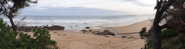
Colour photograph of Wild Dog Creek flowing in to the beach at Apollo Bay near the rocky outcrop known as Match Point.apollo bay, wild dog creek, match point, beach, coast -
 Ballarat Heritage Services
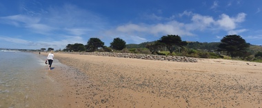
Photograph - seascape, Clare Gervasoni, Wild Dog Creek at Apollo Bay, 19/09/2020
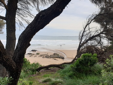
Colour photograph of Wild Dog Creek flowing in to the beach near the rocky outcrop known as Match Point, Apollo Bay.apollo bay, wild dog creek, match point, beach, coast -
 Ballarat Heritage Services
Photograph, Clare Gervasoni, Rocks Near Wild Dog Creek, Apollo Bay, 24/01/2022
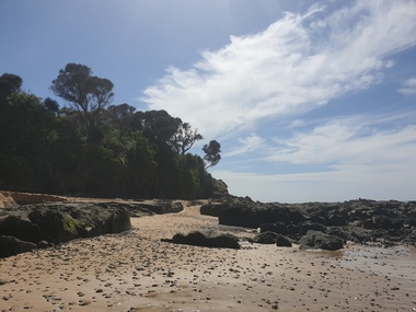
Colour photograph of rocks on the beach at Apollo Bay at a rocky outcrop known as Match Point.apollo bay, match point, beach, coast, rocks -
 Ballarat Heritage Services
Photograph, Clare Gervasoni, Rocks Near Wild Dog Creek, Apollo Bay, 24/01/2022
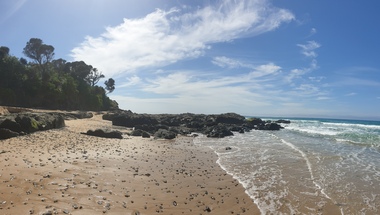
Colour photograph of rocks on the beach at Apollo Bay at a rocky outcrop known as Match Point.apollo bay, match point, beach, coast, rocks -
 Ballarat Heritage Services
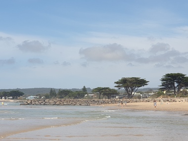
Photograph, Clare Gervasoni, Apollo Bay, Victoria, 24/01/2022
In 2021, the Department of Environment, Land, Water and Planning (DELWP) constructed two new groynes and a section of rock seawall at Apollo Bay to help manage the impacts of coastal erosion. The new 70-meter-long rock groynes run perpendicular to the shoreline and be located just south of the Milford St revetment and to the south of Milford Creek. Sections of rock seawall will be constructed between the two Groynes with an aim to protect the dune, walking path, cypress trees and road from erosion. Colour photograph of a coastal scene at Apollo Bay, featuring new rock groynes to protect the Great Ocean Road from erosion. apollo bay, beach, coast, groyne, rockwall -
 Ballarat Heritage Services
Photograph, Clare Gervasoni, Apollo Bay, Victoria, 24/01/2022
In 2021, the Department of Environment, Land, Water and Planning (DELWP) constructed two new groynes and a section of rock seawall at Apollo Bay to help manage the impacts of coastal erosion. The new 70-meter-long rock groynes run perpendicular to the shoreline and be located just south of the Milford St revetment and to the south of Milford Creek. Sections of rock seawall will be constructed between the two Groynes with an aim to protect the dune, walking path, cypress trees and road from erosion. Colour photograph of a coastal scene at Apollo Bay, featuring new rock wall and groynes to protect the Great Ocean Road from erosion. apollo bay, beach, coast, groyne, rockwall -
 Ballarat Heritage Services
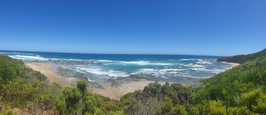
Photograph, Clare Gervasoni, Crayfish Bay, Victoria
Coastal scenes at Crayfish Bay, Victoriacrayfish bay, beach, coast, great ocean road, otways -
 Ballarat Heritage Services
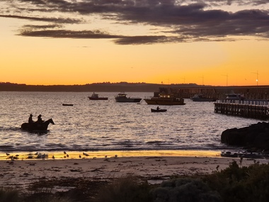
Photograph, Warrrnambool Dawn, 2020, 29/06/2020
Colour photograph of horses swimming at Warrnambool breakwater.warrnambool, horse, beach, coast, dawn -
 Ballarat Heritage Services
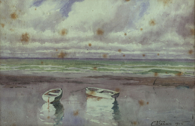
Painting - Artwork - painting, Colin Colahan, 'The Mouth of the Carrum Creek' by Colin Colahan, 1915
Colin COLAHAN (1897-1987) Born Australia Colin Colahan was a student of Max Meldrum, and was one of the first tonalist painters to have his work purchased by the National Gallery of Victoria. He contributed cartoons to 'The Bulletin'. Colahan was working in Paris in the 1920s and had a studio in Mont Martre. He returned to Melbourne by 1927. He next lived and worked in London in 1936 for the next 22 years. During World War Two his house in Chelsea was bombed and everything destroyed. Some photographs donated to Xavier College, his alma mater, are the only evidence of the destroyed work. Cola ham was an Australian War Artist after 1942, with over 90 of his works held by the Australian War Memorial. He moved permanently to Itsly in 1958. Images of a framed watercolour by Colin Colahan. Signed lr "Colin Colahan 1915"colin colahan, watercolour, boats, coast, beach -
 Bayside Gallery - Bayside City Council Art & Heritage Collection
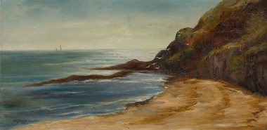
Painting - oil on canvas, I.M. Stone, Sandringham Beach, 1924
I.M. Stone, Sandringham Beach 1924, 43.6 x 90 cm. Bayside City Council Art and Heritage Collection.sandringham, beach, coast, port phillip bay, yacht -
 Lakes Entrance Historical Society
Photograph - Lakes Entrance, 1985c
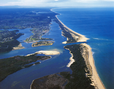
Photo was cut from Tourist brochureColour photograph showing aerial view of township and the Ninety Mile Beach. Pecks factory on Bullock Island, Old North Arm bridge, bitumen for carpark for future. Fishermen's Club near North Arm Bridge. Photo shows East end of Rigby Island and Snake Island. Glimpse of Red Bluff, Lake Bunga and Lake Tyers in far east. Lakes Entrance Victoriabridges, coast, waterways, topography, township -
 Lakes Entrance Historical Society
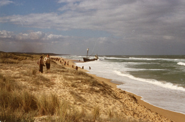
Photograph - Dageraad, 1981
Vessel went aground 26 April 1981Colour photograph showing view of the stranded fishing vessel Dagaraad which ran aground on the 90 mile beach. Many people on beach. Lakes Entrance Victoriaships and shipping, shipwrecks, media, coast, fishing industry -
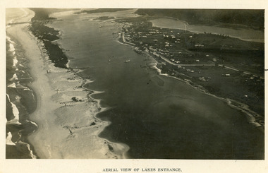 Lakes Entrance Historical Society
Photograph - Lakes Entrance, 1923c
Two copies 16.5 x 25.5 very darkBlack and white photograph showing early aerial view of township of Lakes Entrance, photo shows highway going along Myer Street and along Roadknight Street, no shops in Myer Street appears to be no foot bridge, therefore taken prior to 1937, sparce vegetation on foreground dunes, four barriers built on dunes to stop erosion through sand, two masted sailing boat in lake. Bullock Island in distance appears very small, Snake Island of Rigby Island in centre distance. Lakes Entrance VictoriaAerial View of Lakes Entrancewaterways, coast, aerial photograph, islands, township -
 Lakes Entrance Historical Society
Photograph - Foreshore Lakes Entrance, Bulmer H D, 1923c
Second copyBlack and white photograph showing aerial view of the entrance to the Gippsland Lakes, shows Cunninghame Arm, North Arm, Reeves River and Hopetoun Channel, Rigby Island and Snake Island, the barrier on right foreground. Lakes Entrance Victoriawaterways, islands, aerial photograph, fishing industry, coast -
 Lakes Entrance Historical Society
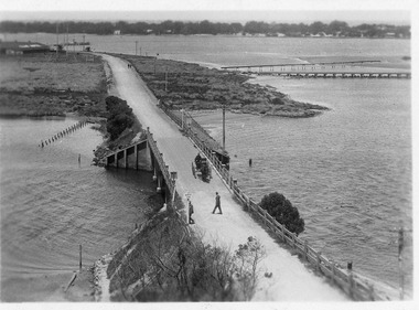
Postcard - North Arm bridge Lakes Entrance Victoria, 1917c
Also sepia toned photographic print 10cmx15cm, good condition old cat No 310 or 318? (Club Hotel and Hummocks area cropped from top) also Black and white photographic print 12.5cmx18cm, good condition- 2 copies 'Original T-Beam bridge opened Sept 1917 on reverse P01151-3.Black and white photographic miniature postcard showing the concrete bridge over the North Arm, showing the extended abutments, and shortened bridge length compared to previous bridge, causing restriction of waterway. Two walkers and horse drawn vehicle, buggy, on bridge. Remaining piles of wooden bridge upstream of bridge, telegraph poles upstream of bridge and across mudflats. Bridge to Bullock Island from mudflat, Club Hotel, Cunninghame Arm, and sand hummocks in distance. Lakes Entrance Victoriabridges, waterways, coast, transport, hotels -
 Lakes Entrance Historical Society
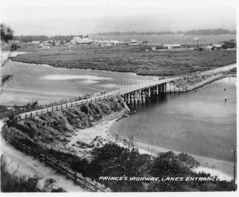
Postcard - North Arm bridge Lakes Entrance Victoria, 1920c
Also 2x identical fade P)1151-2,3Black and white miniature postcard of the concrete bridge spanning the North Arm, showing the bridge and abutments,road to bridge from Kalimna, and post and rail fences along road, grass covered mud flats with Club Hotel, Methodist Church and Maranui Guesthouse in distance amongst other buildings. Cunninghame Arm and sand hummocks in far distance. Sandbars visible in North Arm. Lakes Entrance VictoriaPrincess highway Lakes Entrancebridges, coast, religion, hotels, guesthouses -
 Hymettus Cottage & Garden Ballarat
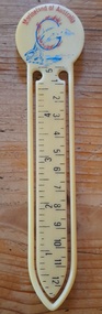
Functional object - Bookmark, Marineland of Australia
Marineland of Australia, was located on the Gold Coast, Queensland Australia operating from 1965, until 1976.gold coast, queensland, marineland, aquarium, sea life, bookmark, souvenir, tourist attraction -
 Warrnambool and District Historical Society Inc.
Booklet - Warrnambool Visitor's Handbooks 1979-2024, Collett, Bain and Gaspar, Printers, 1979-2014
This is a collection of eight Warrnambool Visitor handbooks produced between 1979 and 2014 by the City of Warrnambool Tourist Information Centre. They contain maps of Warrnambool, lists of services, accommodation and tourist attractions as well as many advertisements for local businesses.These handbooks give a useful snapshot of businesses and tourist attractions in Warrnambool for each of the years covered. (1979, 1980, 1986, 1990, 1993, 1994, 1995, 2014)[.1a] A 48 page booklet with white pages and blue printing. The front cover has a coloured photograph of Flagstaff Hill with boats on a man made lake in the foreground looking across Lake Pertobe toward South Warrnambool. [.1b] A coloured bifold brochure. The front cover has a fisherman on a cray-boat holding a crayfish in the lower section. The top quarter has a blue back ground with white printing. The rear cover is red and has small photos of the Hopkins River and the Framlingham Forest. [.2] A 48 page booklet with white pages and black printing. The front cover is white with black writing on the left hand side and a colour photograph of the Loch Ard peacock. The Warrnambool Premier Town stylised logo of seven Norfollk pines above blue waves is in the top right hand corner. There is a blank ink Warrnambool Library stamp underneath the logo. The rear cover has photographs of The Twelve Apostles and the Hopkins Falls and the Premier Town Logo [.3] A 40 page booklet with mainly black printing on white paper. There are three fold out maps of Warrnambool and the surrounding district. The glossy cover has a black background with a colour photograph of the Twelve Apostles taken at sunset. The rear cover has three small of Proudfoot's boathouse on the Hopkins River, Flagstaff Hill, and the main beach area. The front cover has black writing inside to peach coloured rectangles. The inside rear cover has a fold out coloured tour map of Western Victoria. [.4] A 40 page booklet printed on glossy white paper with coloured photographs and black and red printing. The front cover has a photograph of The Twelve Apostles surrounded by a white border. There is red writing in the upper border. There is a sandy coloured writing superimposed across the bottom of the photograph and a Victoria's Shipwreck Coast logo in the bottom right hand corner. [.5] A 44 page booklet printed on white paper with black printing. The cream coloured cover has a pale red rectangle with blue writing on the right hand facing edge and includes two stylised Norfolk pines and with waves underneath. There is is an intersecting blue rectangle with cream printing. [.6] A 48 page booklet printed on white paper with black printing. The cover is brown with a cream vertical strip containing black writing on the right hand side. There is a stylised map from Geelong to Mount Gambier showing the Great Ocean Road across the cover. [.7] A 48 page booklet printed on white paper with black print. The glossy colour cover has a photograph of a Southern Right whale fluke. There is white printing on a the blue background of the sky and sea. The bottom left hand side of the front cover has a Tourism Victoria logo made of jigsaw puzzle pieces. The back cover has a stylised coloured map of The Great Ocean Road located in a white rectangle at the top of the page. Within the rectangle is a small map of Australia locating Victoria and the part of Victoria covered by the map. [.8] A 64 page A5 coloured booklet printed on white pages with black print. The white front cover has black and grey print with a colour photograph of two people holding coffee cups watching four race horses being exercised on the beach and in the water of Lady Bay in the early morning. The bottom right hand corner has a Tourism Victoria logo. The rear cover has a mainly blue back ground with a pink orange and green colour splats contains words advertising the 2015 Fun 4 Kids Festival [.1a] Warrnambool The Heart of Victoria's Great Southwest Visitor's Handbook [.1b] Warrnambool City for all seasons; The Heart of Victoria's Great Southwest [.2] Warrnambool visitor's handbook Warrnambool Premier Town 1979-1982 [.3] Warrnambool Handbook Victoria [.4] Warrnambool The Shipwreck Coast [.5] Welcome to Warrnambool Warrnambool Visitors Handbook 1993-1994 [.6] Welcome to Warrnambool Visitors Handbook 1994-95 Rear cover: Warrnambool Centre of Victoria's Shipwreck Coast on Australia's Great Ocean Road [.7] Warrnambool Shipwreck Coast - Great Ocean Road; You'll love every piece of Victoria; Visitors Handbook [.8] Warrnambool Great Ocean Road Official Visitor Guide; It's a wonderful Warrnambool; You'll love every piece of Victoria visitvictoria.com. Rear Cover Live entertainment.Workshops.Creativity.Action 28 June - 5 July 2015 Australia's Best Children's Festival F4K The ultimate winter school holiday adventure Fun 4 kids festival Warrnambool For more information visit Fun4kids.com.au Warrnambool great Ocean Road Victoriawarrnambool, visitor handbooks, tourist information guides, warrnambool maps -
 Tatura Irrigation & Wartime Camps Museum
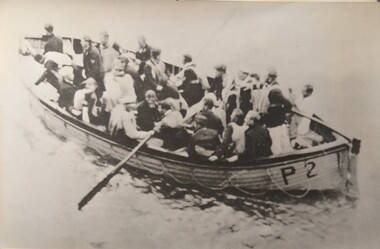
Photograph, Kormoran Survivors in Lifeboat P2
Survivors of the German Auxiliary Cruiser Kormoran in a lifeboat, P2, after sinking HMAS Sydney of the WA coast.historicBlack and white photograph of a number of men in a life boat, with P2 on the side, with 1 oar on the left hand side.german auxiliary cruiser kormoran, kormoran, kormoran survivors, kormoran lifeboat p2 -
 National Wool Museum
Certificate, Certificate of Recognition
Certificate of Recognition for services to the Geelong Coast Tennis Association, presented to Bob Pettitt, 5th Nov 1983.Bob Pettitt Trevor Colbertgeelong coast tennis association, pettitt, mr r. w. -
 Woolamai Beach Surf Life Saving Club
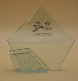
Award - Glass Trophy, 2007 S.L.S.A. & D.H.L. Australian Surf Club of the Year, 2007
2007 S.L.S.A - D.H.L. Surf Life Saving Club of the Year. Awarded to the best Club on the Australian coastWoolamai won the top Award in 2007, which was also the "Year of the Lifesaver"Glass Trophy2007 Year of the Life Saver D.H.L. Club of the Year -
 Bendigo Historical Society Inc.
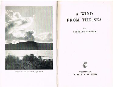
Book - ALEC H CHISHOLM COLLECTION: BOOK ''A WIND FROM THE SEA'' BY GERTRUDE DEMPSEY
Book. ALEC H CHISHOLM COLLECTION. 129 page memoir about the beaches of the coast north of Wellington, New Zealand. Illustrated with 16 B & W photographs. Published in 1950 by A.H. & A. W. Reed, Wellington and printed at The Herald Printing Works, Timaru. Catalogue sticker ''2154 DEM'' on spine. Handwritten in ink on flyleaf ''With the Author's compliments Gertrude Dempsey 4.10.1950''.Gertrude Dempseybooks, collections, memoir, alec h chisholm collection, gertrude dempsey, wellington, new zealand, memoir, nature -
 Tennis Australia
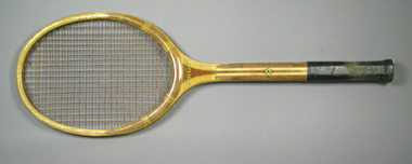
Racquet, Circa 1935
A wooden racquet with black leather handle grip. Inscription, starting across base of head of obverse, and down the stem, reads: NARRAGANSETT/EIGHTY/NARRAGANSETT MACHINE CO./.../"LIVE-WOOD"/.../PAWTUCKET, R.I. Inscription across base of head on reverse: GOLD COAST. Company symbol features below on stem. Materials: Wood, Glue, Lacquer, Ink, Leather, String, Guttennis -
 Bendigo Historical Society Inc.
Slide - DIGGERS & MINING. GOLD, c1878
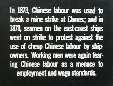
Diggers & Mining. Gold. In 1873, Chinese labour was used to break a mine strike at Clunes; and in 1878, seamen on the east-coast ships went on strike to protest against the use of cheap Chinese labour by ship owners. Working men were again fearing Chinese labour as a menace to employment and wage standards. Markings: 10 994.GOL. Used as a teaching aid.hanimounteducation, tertiary, goldfields -
Clunes Museum
Magazine - MAGAZINES
.1 SLOW magazine, article on Clunes, Victoria, Australia - Issue two, late spring 2009 - pages 62-63 .2 LIFE & STYLE magazine, article on Clunes, Victoria, Australia - Issue No.2 - pages 78-83 3. COAST & COUNTRY magazine, article on Clunes, Victoria, Australia - Edition Two Vol 7 No.2 2007 - pages 30-36advertorial publication, slow, coast & country, life & style -
 Federation University Historical Collection
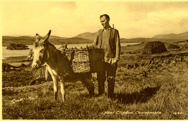
Postcard - black and white, Near Clifden, Connemara, Ireland
Set between the Atlantic Ocean, 12 Ben Mountains and preserved boglands, lies the town of Clifden on the Coast of Connemara.A man stands beside a donkey carry two baskets. It is possibly on the Derrygimlagh Bogchatham-holmes family collection, clifden, derrygimlagh, bog -
 Bendigo Military Museum
Card - LETTER CARDS, 1944
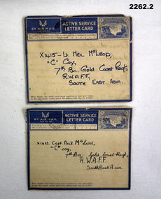
Letters to Lt. Neil McLeod X1415 "C" Coy, 7th Bn Gold Coast Regiment, R.W.A.F.F, South East Asia. “R.W.A.F.F”. Royal West African Frontier Force. The Gold Coast regiment consisted of 9 Battalions. McLeods unit served in Burma 1944. Six of the regiments Bn’s served in Burma. There are 21 Catalogue items in the collection all referred to this Cat No.Folded in 4, letters, paper with lines and hand written in ink. (sent by air mail par avion) stamp (imprint) top, right corner with graphic of Victoria Falls and 3d (threepence) price on stamp.Hand written letters from “John and Gill McLeod”letters, cards, airmail -
 Bendigo Military Museum
Photograph - PHOTOGRAPH FRAMED - WW1, Wayne Eels, C.2008/2009
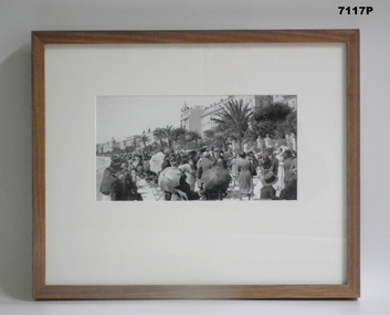
The Grinton Collection. Promenade along the Mediterranean coast of Nice France. Refer Cat No. 1280 for Jack Grintons service details. Photograph framed. Photograph - black and white photograph on paper. Depicting - a promenade space filled with civilians seated and standing with a background of tree and buildings. Frame - timber, light varnish finish, Perspex front, cardboard backing."Group 3: Trip of a Lifetime". "D. Promenade des Anglais".framed accessories, camera on the somme, 38th bn, grinton, ww1, nice -
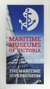 Mission to Seafarers Victoria
Booklet - Leaflet, Maritime Museums of Victoria, Maritime Museums of Victoria - The Maritime Supermuseum, 2017
Maritime Museums of Victoria is a network of sixteen museum sites in the State of Victoria along the Coast but also along the Murray River.The network was created in 2007. The Mission joined the network in July 2013 and the Mission hosts meetings on occasions.Three-fold A4 brochure on glossy colour papermaritime museums of victoria, network, victoria, mmv, interest group, membership -
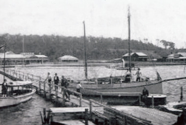 Lakes Entrance Historical Society
Photograph, 1920 c
Also in album is photocopy of page from Don Loves book 'Shipwrecks on the East Gippsland Coast', of the SS Bogong 1896Black and white photograph showing boats at jetty, Eva on right and other tourist type boats, several people on jetty and boats. Broomes Federal guest house on left, Venga next, dark house on site of Robin Hood Inn, Kalimna Heights in background. Lakes Entrance Victoriaships and shipping, waterways, retail trade