Showing 750 items
matching contractor
-
 Whitehorse Historical Society Inc.
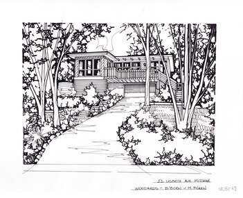
Artwork, other - Ink Line Drawing, Margaret Picken, 52 Lisbeth Ave., Mitcham, circa 1990's-2000's
A property illustration by Margaret Picken Commissioned by a real estate agency for the purpose of advertising 52 Lisbeth Ave., Mitcham Made by using Rotring ‘Rapidigraph’ drafting pens with Rotring ink on Rapidigraph polyester drafting film, double matte. Trained as a cartographic draftsman within the mining industry, Margaret Picken is an artist who worked producing property illustrations for real estate agencies in eastern suburbs of Victoria from 1983-2005. Retiring from the industry as technological changes favored coloured photography over illustrations, and commissioning companies over sole contractors.This artwork is of Historical Significance as a record of local domestic architecture.A black ink line drawing on drafters film by Margaret Picken, of 52 Lisbeth Ave., Mitcham depicting a black and white line drawing of a two story house with built in garage perched at the top of a steep driveway winding up from the centre foreground. There is garden either side, with gumtrees and shrubs. There are two holepunch holes centered just under the upper edge52 Lisbeth Ave., Mitcham Woodards - b/burn - M.Pickenwhitehorse historical society, schwerkolt cottage, housing, architecture, margaret picken, house, garden, real estate, mitcham -
 Whitehorse Historical Society Inc.
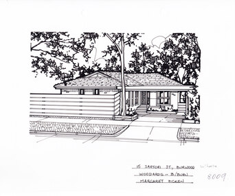
Artwork, other - Ink Line Drawing, 15 Satori St., Burwood, circa 1983-2005
A property illustration by Margaret Picken Commissioned by the real estate agency Woodards for the purpose of advertising 15 Satori St., Burwood Made by using Rotring ‘Rapidigraph’ drafting pens with Rotring ink on Rapidigraph polyester drafting film, double matte. Trained as a cartographic draftsman within the mining industry, Margaret Picken is an artist who worked producing property illustrations for real estate agencies in eastern suburbs of Victoria from 1983-2005. Retiring from the industry as technological changes favored coloured photography over illustrations, and commissioning companies over sole contractors.This artwork is of Historical Significance as a record of local domestic architecture.A black ink line drawing on drafters film by Margaret Picken, of 15 Satori St., Burwood. A single story brick house, with a driveway on the left leading to a connected carport which covers the front door. in the foreground is a horizontal plank timber fence, and a tall gumtree.15 Satori St., Burwood Woodards - B.Burn Margaret Pickenwhitehorse historical society, schwerkolt cottage, housing, architecture, margaret picken, burwood, house, garden -
 Whitehorse Historical Society Inc.
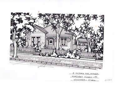
Artwork, other - Ink Line Drawing, Margaret Picken, 8 Victoria Ave., Mitcham, 1995
A property illustration by Margaret Picken Commissioned by a real estate agency for the purpose of advertising 8 Victoria Ave., Mitcham Made by using Rotring ‘Rapidigraph’ drafting pens with Rotring ink on Rapidigraph polyester drafting film, double matte. Trained as a cartographic draftsman within the mining industry, Margaret Picken is an artist who worked producing property illustrations for real estate agencies in eastern suburbs of Victoria from 1983-2005. Retiring from the industry as technological changes favored coloured photography over illustrations, and commissioning companies over sole contractors.This artwork is of Historical Significance as a record of local domestic architecture.A black ink line drawing on drafters film by Margaret Picken, of 8 Victoria Ave., Mitcham depicting a black and white line drawing of a single story weatherboard cottage, with corrugated roof. In the foreground is a picket fence enclosing a heavily planted front yard. On the right a weatherboard 'cubby' can be seen over the garden fence. There are two holepunch holes on just under the upper edge 8 Victoria Ave., Mitcham Margaret Picken - 95 Woodards - C'wellwhitehorse historical society, schwerkolt cottage, housing, architecture, margaret picken, house, garden, real estate, mitcham -
 Whitehorse Historical Society Inc.
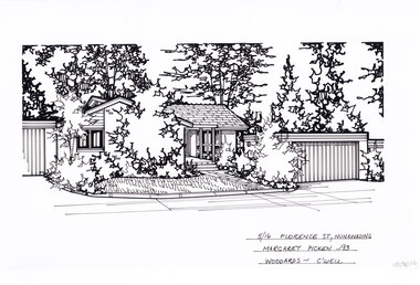
Artwork, other - Ink Line Drawing, Margaret Picken, 5/16 Florence St., Nunawading, 1993
A property illustration by Margaret Picken Commissioned by a real estate agency for the purpose of advertising 5/16 Florence St., Nunawading Made by using Rotring ‘Rapidigraph’ drafting pens with Rotring ink on Rapidigraph polyester drafting film, double matte. Trained as a cartographic draftsman within the mining industry, Margaret Picken is an artist who worked producing property illustrations for real estate agencies in eastern suburbs of Victoria from 1983-2005. Retiring from the industry as technological changes favored coloured photography over illustrations, and commissioning companies over sole contractors.This artwork is of Historical Significance as a record of local domestic architecture.A black ink line drawing on drafters film by Margaret Picken, of a black and white line drawing of a single story brick house with a path leading to the front door, from the public footpath. To the right is the separate garage. Trees and shrubs grow in garden beds in front of the buildings and in the background, while in front of the house is a front lawn. There are two holepunch holes centred just under the upper edge.5/16 Florence St., Nunawading Margaret Picken - 93 Woodards - C'wellwhitehorse historical society, schwerkolt cottage, housing, architecture, margaret picken, house, garden, real estate, nunawading -
 Whitehorse Historical Society Inc.
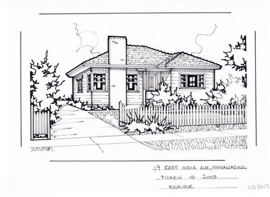
Artwork, other - Ink Line Drawing, Margaret Picken, 1/9 East India Ave., Nunawading, 2003
A property illustration by Margaret Picken Commissioned by a real estate agency for the purpose of advertising 27 Crest Gve., Nunawading Made by using Rotring ‘Rapidigraph’ drafting pens with Rotring ink on Rapidigraph polyester drafting film, double matte. Trained as a cartographic draftsman within the mining industry, Margaret Picken is an artist who worked producing property illustrations for real estate agencies in eastern suburbs of Victoria from 1983-2005. Retiring from the industry as technological changes favored coloured photography over illustrations, and commissioning companies over sole contractors.This artwork is of Historical Significance as a record of local domestic architecture.A black ink line drawing on drafters film by Margaret Picken, of a black and white line drawing of a single story weatherboard house, with a front facing chimney . To the left is a driveway and on the right is a picket fence enclosing a front lawn with garden bed around the edges. The date listed in the title inscription has been overwritten from 95 in black ink, to 97, the 7 being in red ink. 1/9 East India Ave., Nunawading Picken © 2003 Realtorwhitehorse historical society, schwerkolt cottage, housing, architecture, margaret picken, house, garden, real estate, nunawading -
 Whitehorse Historical Society Inc.
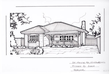
Artwork, other - Ink Line Drawing, Margaret Picken, 24 Menin Road., Nunawading, 2004
A property illustration by Margaret Picken Commissioned by a real estate agency for the purpose of advertising 3 Lynne St., Nunawading. Made by using Rotring ‘Rapidigraph’ drafting pens with Rotring ink on Rapidigraph polyester drafting film, double matte. Trained as a cartographic draftsman within the mining industry, Margaret Picken is an artist who worked producing property illustrations for real estate agencies in eastern suburbs of Victoria from 1983-2005. Retiring from the industry as technological changes favored coloured photography over illustrations, and commissioning companies over sole contractors.This artwork is of Historical Significance as a record of local domestic architecture.A black ink line drawing on drafters film by Margaret Picken, of a black and white line drawing of a single story weatherboard house with bullnose verandah over the front porch. In the foreground a driveway widens to lead to a gated separate garage in the background, and curve around to the front of the house.. In the left foreground corner is a font garden. There are two holepunch holes on just under the upper edge.24 Menin Road., Nunawading Picken © 2004 Realtorwhitehorse historical society, schwerkolt cottage, housing, architecture, margaret picken, house, garden, real estate, nunawading -
 Whitehorse Historical Society Inc.
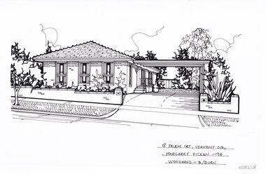
Artwork, other - Ink Line Drawing, Margaret Picken, 18 Salem Crt., Vermont Sth, 1994
A property illustration by Margaret Picken Commissioned by a real estate agency for the purpose of advertising 18 Salem Crt., Vermont Sth Made by using Rotring ‘Rapidigraph’ drafting pens with Rotring ink on Rapidigraph polyester drafting film, double matte. Trained as a cartographic draftsman within the mining industry, Margaret Picken is an artist who worked producing property illustrations for real estate agencies in eastern suburbs of Victoria from 1983-2005. Retiring from the industry as technological changes favored coloured photography over illustrations, and commissioning companies over sole contractors.This artwork is of Historical Significance as a record of local domestic architecture.A black ink line drawing on drafters film by Margaret Picken, of a single story brick house with attached carport on the right. A low staggered brick fence separates the front yard from the street, opening up for a driveway that leads to the carport. There are two hole punch holes just below centre of the upper edge.18 Salem Crt., Vermont Sth, Margaret Picken - 94 Woodards - B/Burnwhitehorse historical society, schwerkolt cottage, housing, architecture, margaret picken, house, garden, real estate, vermont, vermont south -
 Whitehorse Historical Society Inc.
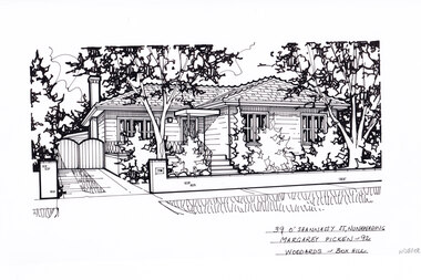
Artwork, other - Ink Line Drawing, Margaret Picken, 39 O'Shannassy St., Nunawading, 1992
A property illustration by Margaret Picken Commissioned by a real estate agency for the purpose of advertising 39 O'Shannassy St., Nunawading Made by using Rotring ‘Rapidigraph’ drafting pens with Rotring ink on Rapidigraph polyester drafting film, double matte. Trained as a cartographic draftsman within the mining industry, Margaret Picken is an artist who worked producing property illustrations for real estate agencies in eastern suburbs of Victoria from 1983-2005. Retiring from the industry as technological changes favored coloured photography over illustrations, and commissioning companies over sole contractors.This artwork is of Historical Significance as a record of local domestic architecture.A black ink line drawing on drafters film by Margaret Picken, of a black and white line drawing of a single story weatherboard house. On the left is a driveway leading to a gated separate garage. While in the foreground on the right is low brick fence, enclosing a front garden. There are two holepunch holes on just under the upper edge.39 O'Shannassy St., Nunawading Margaret Picken - 92 Woodards - Boxhillwhitehorse historical society, schwerkolt cottage, housing, architecture, margaret picken, house, garden, real estate, nunawading -
 Whitehorse Historical Society Inc.
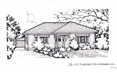
Artwork, other - Ink Line Drawing, Margaret Picken, 56 Mt.Pleasant Rd., Nunawading, Circa 1980's-2010's
A property illustration by Margaret Picken Commissioned by a real estate agency for the purpose of advertising 3 Lynne St., Nunawading. Made by using Rotring ‘Rapidigraph’ drafting pens with Rotring ink on Rapidigraph polyester drafting film, double matte. Trained as a cartographic draftsman within the mining industry, Margaret Picken is an artist who worked producing property illustrations for real estate agencies in eastern suburbs of Victoria from 1983-2005. Retiring from the industry as technological changes favored coloured photography over illustrations, and commissioning companies over sole contractors.This artwork is of Historical Significance as a record of local domestic architecture.A black ink line drawing on drafters film by Margaret Picken, of a black and white line drawing of a single story weatherboard house. On the left is a driveway leading to a separate garage in the background, while in foreground on the right is a front garden, with a footpath to the front door.56 Mt.Pleasant Rd., Nunawadingwhitehorse historical society, schwerkolt cottage, housing, architecture, margaret picken, house, garden, real estate, nunawading -
 Whitehorse Historical Society Inc.
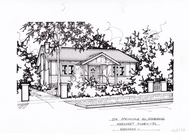
Artwork, other - Ink Line Drawing, Margaret Picken, 274 Springfield Rd., Nunawading, 1994
A property illustration by Margaret Picken Commissioned by a real estate agency for the purpose of advertising 274 Springfield Rd., Nunawading Made by using Rotring ‘Rapidigraph’ drafting pens with Rotring ink on Rapidigraph polyester drafting film, double matte. Trained as a cartographic draftsman within the mining industry, Margaret Picken is an artist who worked producing property illustrations for real estate agencies in eastern suburbs of Victoria from 1983-2005. Retiring from the industry as technological changes favored coloured photography over illustrations, and commissioning companies over sole contractors.This artwork is of Historical Significance as a record of local domestic architecture.A black ink line drawing on drafters film by Margaret Picken, of a black and white line drawing of a single story house, on the left is a driveway leading into the background. While in the right foreground is a front garden, with a path to the front door.274 Springfield Rd., Nunawading Margaret Picken -92 Woodards -whitehorse historical society, schwerkolt cottage, housing, architecture, margaret picken, house, garden, real estate, nunawading -
 Kew Historical Society Inc
Plan, Borough of Kew Detail Plan No.1577, 1904
The Melbourne and Metropolitan Board of Works (MMBW) plans were produced from the 1890s to the 1950s. They were crucial to the design and development of Melbourne's sewerage and drainage system. The plans, at a scale of 40 feet to 1 inch (1:480), provide a detailed historical record of Melbourne streetscapes and environmental features. Each plan covers one or two street blocks (roughly six streets), showing details of buildings, including garden layouts and ownership boundaries, and features such as laneways, drains, bridges, parks, municipal boundaries and other prominent landmarks as they existed at the time each plan was produced. (Source: State Library of Victoria)This plan forms part of a large group of MMBW plans and maps that was donated to the Society by the Mr Poulter, City Engineer of the City of Kew in 1989. Within this collection, thirty-five hand-coloured plans, backed with linen, are of statewide significance as they include annotations that provide details of construction materials used in buildings in the first decade of the 20th century as well as additional information about land ownership and usage. The copies in the Public Record Office Victoria and the State Library of Victoria are monochrome versions which do not denote building materials so that the maps in this collection are invaluable and unique tools for researchers and heritage consultants. A number of the plans are not held in the collection of the State Library of Victoria so they have the additional attribute of rarity.Original survey plan, issued by the MMBW to a contractor with responsibility for constructing sewers in the area identified on the plan within the Borough of Kew. The plan was at some stage hand-coloured, possibly by the contractor, but more likely by officers working in the Engineering Department of the Borough and later Town, then City of Kew. The hand-coloured sections of buildings on the plan were used to denote masonry or brick constructions (pink), weatherboard constructions (yellow), and public buildings (grey). MMBW Plan No.1577 includes some of the most significant houses in Kew: Herbert Henty’s ‘Roxeth’ (now part of Trinity Grammar), ‘Butleigh Wooton’, ‘Bokara’ and ‘Harrow’. It also includes the streets that have since changed their names. That part of College Parade linked to Glenferrie Road is now named College Place, College Parade now extends further north, and Charles Street did not yet reach Barkers Road. Roxeth is one of a number of Henty houses in Kew. Herbert Henty made his home here and was elected a member of Kew Municipal Council in 1864 and mayor in 1868-69. Walter Henry Serle, of Harrow served in the First World War. He was awarded the Military Medal ‘’For conspicuous bravery and devotion to duty. On 29th September near BELLICOURT he showed the greatest bravery and determination when his platoon was attacked by enemy bombing parties. It was due largely to his personal efforts that all the attacks were repulsed. Until wounded, his utter disregard of personal safety and boldness in dealing with the attacks were the means of saving the situation and were an inspiring example to his men.’melbourne and metropolitan board of works, detail plans, maps - borough of kew, mmbw 1577, cartography -
 Kew Historical Society Inc
Plan, Melbourne & Metropolitan Board of Works : Borough of Kew : Detail Plan No.1582, 1904
The Melbourne and Metropolitan Board of Works (MMBW) plans were produced from the 1890s to the 1950s. They were crucial to the design and development of Melbourne's sewerage and drainage system. The plans, at a scale of 40 feet to 1 inch (1:480), provide a detailed historical record of Melbourne streetscapes and environmental features. Each plan covers one or two street blocks (roughly six streets), showing details of buildings, including garden layouts and ownership boundaries, and features such as laneways, drains, bridges, parks, municipal boundaries and other prominent landmarks as they existed at the time each plan was produced. (Source: State Library of Victoria)This plan forms part of a large group of MMBW plans and maps that was donated to the Society by the Mr Poulter, City Engineer of the City of Kew in 1989. Within this collection, thirty-five hand-coloured plans, backed with linen, are of statewide significance as they include annotations that provide details of construction materials used in buildings in the first decade of the 20th century as well as additional information about land ownership and usage. The copies in the Public Record Office Victoria and the State Library of Victoria are monochrome versions which do not denote building materials so that the maps in this collection are invaluable and unique tools for researchers and heritage consultants. A number of the plans are not held in the collection of the State Library of Victoria so they have the additional attribute of rarity.Original survey plan, issued by the MMBW to a contractor with responsibility for constructing sewers in the area identified on the plan within the Borough of Kew. The plan was at some stage hand-coloured, possibly by the contractor, but more likely by officers working in the Engineering Department of the Borough and later Town, then City of Kew. The hand-coloured sections of buildings on the plan were used to denote masonry or brick constructions (pink), weatherboard constructions (yellow), and public buildings (grey). Public buildings, coloured grey on the Plan 1582 include the police station and post office, churches and schools. The earliest church school, Common School No.356 was located at the rear of the Congregational Church in Peel Street. It was constructed in 1859. The first buildings of Kew Primary School No.1075 on the other side of Peel Street were constructed in 1871. The school in 1903 only occupied a small fraction of its current site. In 1903, where the rear playground is now located, were two weatherboard and one brick villa. Trinity Grammar School was founded in 1902 and opened in the Parish Hall at the rear of Holy Trinity Anglican Church. It was not to move to its current site until 1906. The outline of the building housing the Kew Fire Brigade in the centre of the north side of Walton Street is shown but not named on the plan. Further down Pakington Street stood the two-storey Italianate mansion ‘Overton’. The home of Stanford Chapman, it was to be featured in the Imperial Institute series of bromide photographs of Victoria, Vol. 1: Homes and scenery. It was later to become a boarding house before it was later demolished.melbourne and metropolitan board of works, detail plans, maps - borough of kew, mmbw 1582, cartography -
 Kew Historical Society Inc
Plan, Melbourne & Metropolitan Board of Works : Borough of Kew : Detail Plan No.1585, 1904
The Melbourne and Metropolitan Board of Works (MMBW) plans were produced from the 1890s to the 1950s. They were crucial to the design and development of Melbourne's sewerage and drainage system. The plans, at a scale of 40 feet to 1 inch (1:480), provide a detailed historical record of Melbourne streetscapes and environmental features. Each plan covers one or two street blocks (roughly six streets), showing details of buildings, including garden layouts and ownership boundaries, and features such as laneways, drains, bridges, parks, municipal boundaries and other prominent landmarks as they existed at the time each plan was produced. (Source: State Library of Victoria)This plan forms part of a large group of MMBW plans and maps that was donated to the Society by the Mr Poulter, City Engineer of the City of Kew in 1989. Within this collection, thirty-five hand-coloured plans, backed with linen, are of statewide significance as they include annotations that provide details of construction materials used in buildings in the first decade of the 20th century as well as additional information about land ownership and usage. The copies in the Public Record Office Victoria and the State Library of Victoria are monochrome versions which do not denote building materials so that the maps in this collection are invaluable and unique tools for researchers and heritage consultants. A number of the plans are not held in the collection of the State Library of Victoria so they have the additional attribute of rarity.Original survey plan, issued by the MMBW to a contractor with responsibility for constructing sewers in the area identified on the plan within the Borough of Kew. The plan was at some stage hand-coloured, possibly by the contractor, but more likely by officers working in the Engineering Department of the Borough and later Town, then City of Kew. The hand-coloured sections of buildings on the plan were used to denote masonry or brick constructions (pink), weatherboard constructions (yellow), and public buildings (grey). This plan, which covers parts of High Street, Pakington Street and Derby Street is dominated by two historic Kew mansions: ‘Konetta’ and ‘Ramornie’. Ramornie was constructed in 1890 for James Maitland Campbell, three times Mayor of Kew. Sold in 1940, it became a boarding house known as ‘The Towers’. Now a private residence again, it has only one of its three balconies remaining. The location of the missing two balconies can be seen on the plan. In 1903, the grounds of Ramornie included a large tennis court fronting Pakington Street. The rear of the property is shown as extending to Cobden Street. One of Kew’s oldest hotels, the Prospect Hill Hotel on the corner of High and Cobden Street was established in 1858. The outline of the hotel shown on the plan represents the second building on the site. During the 19th century it was often used for electoral meetings. The Prospect Hill Hotel was to be redeveloped again in 1928, by the local architect Robert McIntyre. Since the 1980s, the hotel has been a live music venue, the home of the Melbourne Jazz Club, a restaurant and a liquor outlet.melbourne and metropolitan board of works, detail plans, maps - borough of kew, mmbw 1585, cartography -
 Kew Historical Society Inc
Plan, Melbourne & Metropolitan Board of Works : Borough of Kew : Detail Plan No.1588, 1904
The Melbourne and Metropolitan Board of Works (MMBW) plans were produced from the 1890s to the 1950s. They were crucial to the design and development of Melbourne's sewerage and drainage system. The plans, at a scale of 40 feet to 1 inch (1:480), provide a detailed historical record of Melbourne streetscapes and environmental features. Each plan covers one or two street blocks (roughly six streets), showing details of buildings, including garden layouts and ownership boundaries, and features such as laneways, drains, bridges, parks, municipal boundaries and other prominent landmarks as they existed at the time each plan was produced. (Source: State Library of Victoria)This plan forms part of a large group of MMBW plans and maps that was donated to the Society by the Mr Poulter, City Engineer of the City of Kew in 1989. Within this collection, thirty-five hand-coloured plans, backed with linen, are of statewide significance as they include annotations that provide details of construction materials used in buildings in the first decade of the 20th century as well as additional information about land ownership and usage. The copies in the Public Record Office Victoria and the State Library of Victoria are monochrome versions which do not denote building materials so that the maps in this collection are invaluable and unique tools for researchers and heritage consultants. A number of the plans are not held in the collection of the State Library of Victoria so they have the additional attribute of rarity.Original survey plan, issued by the MMBW to a contractor with responsibility for constructing sewers in the area identified on the plan within the Borough of Kew. The plan was at some stage hand-coloured, possibly by the contractor, but more likely by officers working in the Engineering Department of the Borough and later Town, then City of Kew. The hand-coloured sections of buildings on the plan were used to denote masonry or brick constructions (pink), weatherboard constructions (yellow), and public buildings (grey). This plan shows the original configuration of the Kew Post Office, Court House and Police Station, which had opened in 1888. This configuration was to essentially remain until the purchase of the Court House and Police Station by the City of Boroondara in 2007 and its subsequent renovation. Interestingly, the MMBW surveyors incorrectly labelled parts of the complex. In the triangle in front of the Post Office, before the erection of the Kew Cenotaph in 1925, was located a lawn and the Queen Victoria Jubilee Fountain. While many of the shops on the south side of High street had been constructed by 1903 a number of sites were still used as vegetable gardens. Further along High Street, on the corner of Charles Street, the Salvation Army Barracks can be seen on the plan. These Barracks predate the later Citadel and ‘Young People’s Hall’ that were opened in 1919. At 22 Charles Street can be seen the house of James Venn Morgan. Hailed as the ‘father of Kew’, Morgan arrived in Melbourne in 1840. He was first engaged as a bookmaker, but a fortunate venture on the goldfields enabled him to purchase land in Kew. He conducted a market garden and dairy in Kew for many years.melbourne and metropolitan board of works, detail plans, maps - borough of kew, mmbw 1588, cartography -
 Kew Historical Society Inc
Plan, Melbourne & Metropolitan Board of Works : Borough of Kew : Detail Plan No.1591, 1905
The Melbourne and Metropolitan Board of Works (MMBW) plans were produced from the 1890s to the 1950s. They were crucial to the design and development of Melbourne's sewerage and drainage system. The plans, at a scale of 40 feet to 1 inch (1:480), provide a detailed historical record of Melbourne streetscapes and environmental features. Each plan covers one or two street blocks (roughly six streets), showing details of buildings, including garden layouts and ownership boundaries, and features such as laneways, drains, bridges, parks, municipal boundaries and other prominent landmarks as they existed at the time each plan was produced. (Source: State Library of Victoria)This plan forms part of a large group of MMBW plans and maps that was donated to the Society by the Mr Poulter, City Engineer of the City of Kew in 1989. Within this collection, thirty-five hand-coloured plans, backed with linen, are of statewide significance as they include annotations that provide details of construction materials used in buildings in the first decade of the 20th century as well as additional information about land ownership and usage. The copies in the Public Record Office Victoria and the State Library of Victoria are monochrome versions which do not denote building materials so that the maps in this collection are invaluable and unique tools for researchers and heritage consultants. A number of the plans are not held in the collection of the State Library of Victoria so they have the additional attribute of rarity.Original survey plan, issued by the MMBW to a contractor with responsibility for constructing sewers in the area identified on the plan within the Borough of Kew. The plan was at some stage hand-coloured, possibly by the contractor, but more likely by officers working in the Engineering Department of the Borough and later Town, then City of Kew. The hand-coloured sections of buildings on the plan were used to denote masonry or brick constructions (pink), weatherboard constructions (yellow), and public buildings (grey). That area of Kew bordered by Cotham Road, Park Hill Road, Ermington Lane (now Ermington Place), and Belmont Avenue contained some of the significant homes owned by Kew pioneers. Chief among these was ‘Park Hill’ on an enormous lot facing Park Hill Road. The Jubilee History of 1910 noted, six years after this plan was drawn, that: ‘Park Hill Road, forming the southern boundary of the cemetery, takes its name from Park Hill, the residence of Mr. Thomas Judd, who has resided there since December, 1852.’ Other named houses on the plan include ‘Ferndale’ facing Cotham Road; ‘Ermington’ adjacent to Judd’s Park Hill, facing Park Hill Road; and ‘Gilden’ and ‘Mont Belmont’ facing Belmont Avenue. Mont Belmont was designed by the architectural firm of Reed, Henderson and Smart for William George Lilley in 1887 and was completed in 1888. Lilley was Mayor of Kew in 1887-88, a Justice of the Peace and a member of the first Board of Guardians of Kew’s St. Hilary’s Church of England.melbourne and metropolitan board of works, detail plans, survey plans - borough of kew, mmbw 1591, cartography -
 Kew Historical Society Inc
Plan, Melbourne & Metropolitan Board of Works : Borough of Kew : Detail Plan No.1563, 1905
The Melbourne and Metropolitan Board of Works (MMBW) plans were produced from the 1890s to the 1950s. They were crucial to the design and development of Melbourne's sewerage and drainage system. The plans, at a scale of 40 feet to 1 inch (1:480), provide a detailed historical record of Melbourne streetscapes and environmental features. Each plan covers one or two street blocks (roughly six streets), showing details of buildings, including garden layouts and ownership boundaries, and features such as laneways, drains, bridges, parks, municipal boundaries and other prominent landmarks as they existed at the time each plan was produced. (Source: State Library of Victoria)This plan forms part of a large group of MMBW plans and maps that was donated to the Society by the Mr Poulter, City Engineer of the City of Kew in 1989. Within this collection, thirty-five hand-coloured plans, backed with linen, are of statewide significance as they include annotations that provide details of construction materials used in buildings in the first decade of the 20th century as well as additional information about land ownership and usage. The copies in the Public Record Office Victoria and the State Library of Victoria are monochrome versions which do not denote building materials so that the maps in this collection are invaluable and unique tools for researchers and heritage consultants. A number of the plans are not held in the collection of the State Library of Victoria so they have the additional attribute of rarity.Original survey plan, issued by the MMBW to a contractor with responsibility for constructing sewers in the area identified on the plan within the Borough of Kew. The plan was at some stage hand-coloured, possibly by the contractor, but more likely by officers working in the Engineering Department of the Borough and later Town, then City of Kew. The hand-coloured sections of buildings on the plan were used to denote masonry or brick constructions (pink), weatherboard constructions (yellow), and public buildings (grey). This plan covers the area between Barkers Road, Wrixon Street, Sackville Street and Brougham Place, much of it now occupied by Carey Baptist Grammar and Preshil schools. This was an area of large and prestigious homes in 1903, some with formally laid-out gardens, such as ‘Tower Hill’ and ‘Opawa’. ‘Kalimna’ was built in 1890-91 for William H. Jarman, an accountant, and ‘Blackhall’ at the same time for W.H. Roberts. Blackhall was to be acquired by the Salvation Army in 1915 and renamed ‘Catherine Booth Girls’ Home’. The Home accommodated girls, aged between 4 and 16. Kalimna and Blackhall are of significance as typical and intact late Victorian mansions and as such are two key Victorian buildings to have been built in Kew. Both Blackhall and Kalimna are now part of Preshil. ‘Fairview’ was for a long time occupied by the Sisters of St. Joseph of Cluny as a care home for the elderly, but it is now part of Carey Grammar School, as are the grounds of ‘Wagga Merne’, ‘Weemutta’, ‘Blakely’, ‘Daheim’ and ‘Mildura’ (later ‘Urangeline’), the last being particularly impressive in 1903, with a tennis court, conservatory, outhouses, and two bathrooms!melbourne and metropolitan board of works, detail plans, mmbw 1563, cartography -
 Kew Historical Society Inc
Plan, Melbourne & Metropolitan Board of Works : Borough of Kew : Detail Plan No.1574, 1905
The Melbourne and Metropolitan Board of Works (MMBW) plans were produced from the 1890s to the 1950s. They were crucial to the design and development of Melbourne's sewerage and drainage system. The plans, at a scale of 40 feet to 1 inch (1:480), provide a detailed historical record of Melbourne streetscapes and environmental features. Each plan covers one or two street blocks (roughly six streets), showing details of buildings, including garden layouts and ownership boundaries, and features such as laneways, drains, bridges, parks, municipal boundaries and other prominent landmarks as they existed at the time each plan was produced. (Source: State Library of Victoria)This plan forms part of a large group of MMBW plans and maps that was donated to the Society by the Mr Poulter, City Engineer of the City of Kew in 1989. Within this collection, thirty-five hand-coloured plans, backed with linen, are of statewide significance as they include annotations that provide details of construction materials used in buildings in the first decade of the 20th century as well as additional information about land ownership and usage. The copies in the Public Record Office Victoria and the State Library of Victoria are monochrome versions which do not denote building materials so that the maps in this collection are invaluable and unique tools for researchers and heritage consultants. A number of the plans are not held in the collection of the State Library of Victoria so they have the additional attribute of rarity.Original survey plan, issued by the MMBW to a contractor with responsibility for constructing sewers in the area identified on the plan within the Borough of Kew. The plan was at some stage hand-coloured, possibly by the contractor, but more likely by officers working in the Engineering Department of the Borough and later Town, then City of Kew. The hand-coloured sections of buildings on the plan were used to denote masonry or brick constructions (pink), weatherboard constructions (yellow), and public buildings (grey). This plan shows several very large houses, particularly along Glenferrie Road, and the area now occupied by Ruyton Girls’ School. ‘Tarring’ (incorrectly spelled here as ‘Karring’) was built for Henry Henty in 1872, on part of his original allotment of 20 acres, and ‘Mount View’, which retains its original building and the fountain in the front garden, is part of Ruyton’s Junior School. The most significant change to Tarring and its grounds since 1903, involve the removal of a number of the outbuildings, including a Burmese temple, bought by Henty from the Burmese Exhibit at the Great Exhibition of 1880. It is shown on the plan as a summerhouse. The two-storey mansion, on the corner of Glenferrie Road and Wellington Street, was built in 1891 by leading architect Alfred White as his own home. Having an initial N.A.V. of £160, the house was purchased by a warehouseman Henry Lister, by 1900, when the N.A.V. was recorded at £111. By the turn of the century the house was known as ‘Comaques’. By contrast, much smaller houses are shown in Scott and Byron Streets, including a tiny Mission Hall in Byron Street, which belonged to the Anglican Church from at least 1903 to 1917.melbourne and metropolitan board of works, detail plans, maps - borough of kew, mmbw 1574, cartography -
 Ringwood and District Historical Society
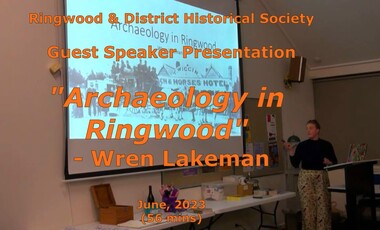
Mixed media - Video, RDHS Guest Speaker Presentation - "Archaeology in Ringwood" - Wren Lakeman
Digitised video (3.17GB). Duration: 56 minutes. Recorded June, 2023 (Video is available for viewing at Ringwood & District Historical Society Archives by appointment)Presenter: Wren Lakeman has a Bachelor of Archaeology and Masters in Professional Archaeology from LaTrobe University, finishing in 2018. She has been working as a sub-contractor for many different archaeology companies and with tickets in excavation, now works for Archstone Archaeology, providers of machinery and operators to archaeological sites all over Australia. For this talk, Wren talks about her work and outlines results of earlier excavations carried out in Ringwood. -
 Bendigo Military Museum
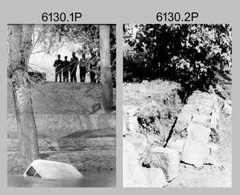
Photograph - Vehicle in Lake Incident - Army Survey Regiment, Fortuna, Bendigo, 1986
This is a set of 12 photographs of contractors removing a vehicle from the lake at the Army Survey Regiment, Fortuna, Bendigo in September 1986. The Ford XB panel van belonging to WO2 Ted Burgess rolled down the embankment during the night from the SGTs Mess carpark. Despite written off by the insurance company, the panel van was remarkably restored by Ted to roadworthy condition and driven in to Fortuna with a shark’s fin mounted on its roof. This incident is covered in more detail in page 152 of Valerie Lovejoy’s book 'Mapmakers of Fortuna – A history of the Army Survey Regiment’ ISBN: 0-646-42120-4.This is a set of 12 photograph of a civilian vehicle being removed from the lake at Army Survey Regiment at Fortuna, Bendigo, September 1986. The photographs were on 35mm negative film and were scanned at 96 dpi. They are part of the Army Survey Regiment’s Collection. .1) to .3) - Photo, black & white, 1986. Vehicle removal from lake. .4) - Photo, black & white, 1986. Vehicle removal from lake, Neil Morgan in foreground. .5) to .8) - Photo, black & white, 1986. Vehicle removal from lake. .9) to .10) - Photo, black & white, 1986. Vehicle removal from lake, Neil Morgan on right. .11) to .12) - Photo, black & white, 1986. Vehicle removal from lake.No personnel are identified. Annotated with date on negative sleeve.royal australian survey corps, rasvy, army survey regiment, army svy regt, fortuna, asr -
 Orbost & District Historical Society
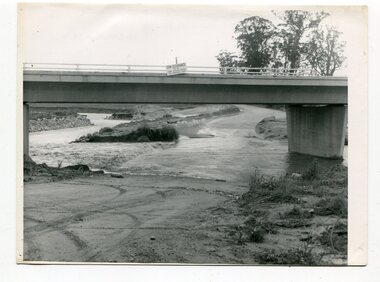
black and white photographs, October 22 1976
The road to Marlo was cut by flood waters from the Snowy River in two places. The road was closed when water flowed over Gilbert's Gulch (3243.1) The Snowy River broke its banks and flooded surrounding Orbost, Marlo, Lochend and Jarrahmond were isolated. The river bank at the bridge site was broken and filled with earth and rock fill. (3243.2) The new Snowy River Bridge was nearing completion when the river rose 7.2 metres causing erosion on the eastern bank. (3243.7) Contractors involved in the construction of the Princes Freeway and bridge were delayed by the flood waters. (3243.8) The 1976 flood at Orbost was a significant event which delayed the construction of the current Snowy River Road Bridge.These photographs record that event.Nine black / white photographs of flood waters across roads. orbost-flood-1976 snowy-river-bridge marlo-road-flood-1976 gilbert;s-gulch-flood -
 Whitehorse Historical Society Inc.
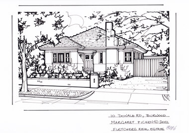
Artwork, other - Ink Line Drawing, 10 Donald Rd., Burwood, 2001
A property illustration by Margaret Picken Commissioned by the real estate agency Fletchers for the purpose of advertising 10 Donald Rd., Burwood in 2001. Made by using Rotring ‘Rapidigraph’ drafting pens with Rotring ink on Rapidigraph polyester drafting film, double matte. Trained as a cartographic draftsman within the mining industry, Margaret Picken is an artist who worked producing property illustrations for real estate agencies in eastern suburbs of Victoria from 1983-2005. Retiring from the industry as technological changes favored coloured photography over illustrations, and commissioning companies over sole contractors.This artwork is of Historical Significance as a record of local domestic architecture.A black ink line drawing on drafters film by Margaret Picken, of 6 Donald St., Burwood. A two story weatherboard house set back from a picket fence and and open gate on the right for the driveway.10 Donald Rd., Burwood Margaret Picken © 2001 Fletchers Real Estatewhitehorse historical society, schwerkolt cottage, housing, architecture, margaret picken, burwood, house, garden -
 Whitehorse Historical Society Inc.
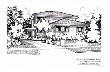
Artwork, other - Ink Line Drawing, Margaret Picken, 4 Pilita St., Forest Hill, 1990
A property illustration by Margaret Picken Commissioned by the real estate agency Woodards Box Hill for the purpose of advertising 4 Pilita St., Forest Hill. Made by using Rotring ‘Rapidigraph’ drafting pens with Rotring ink on Rapidigraph polyester drafting film, double matte. Trained as a cartographic draftsman within the mining industry, Margaret Picken is an artist who worked producing property illustrations for real estate agencies in eastern suburbs of Victoria from 1983-2005. Retiring from the industry as technological changes favored coloured photography over illustrations, and commissioning companies over sole contractors.This artwork is of Historical Significance as a record of local domestic architecture.A black ink line drawing on drafters film by Margaret Picken, of 4 Pilita St., Forest Hill, a two story brick and weather board house set back from a front lawn, with a driveway leading to a connected carport. There are two hole punches centre of the upper edge4 Pilita St., Forest Hill Margaret Picken '90 Woodards - Box Hillwhitehorse historical society, schwerkolt cottage, housing, architecture, margaret picken, house, garden, forest hill -
 Whitehorse Historical Society Inc.
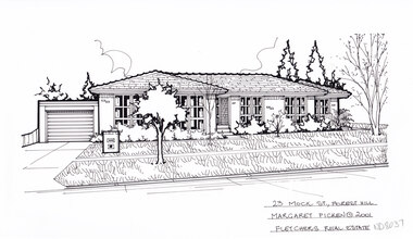
Artwork, other - Ink Line Drawing, Margaret Picken, 23 Mock St., Forest Hill, 2001
A property illustration by Margaret Picken Commissioned by the real estate agency Fletchers Real Estate for the purpose of advertising 23 Mock St., Forest Hill. Made by using Rotring ‘Rapidigraph’ drafting pens with Rotring ink on Rapidigraph polyester drafting film, double matte. Trained as a cartographic draftsman within the mining industry, Margaret Picken is an artist who worked producing property illustrations for real estate agencies in eastern suburbs of Victoria from 1983-2005. Retiring from the industry as technological changes favored coloured photography over illustrations, and commissioning companies over sole contractors.This artwork is of Historical Significance as a record of local domestic architecture.A black ink line drawing on drafters film by Margaret Picken, of 23 Mock St., Forest Hill, of a brick single story house set back from a front lawn with driveway leading to a garage on the left.23 Mock St., Forest Hill Margaret Picken © 2001 Fletchers Real Estatewhitehorse historical society, schwerkolt cottage, housing, architecture, margaret picken, house, garden, forest hill -
 Whitehorse Historical Society Inc.
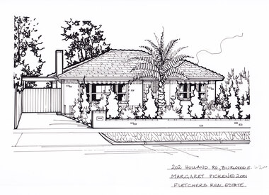
Artwork, other - Ink Line Drawing, 202 Holland Rd., Burwood E, 1994
A property illustration by Margaret Picken Commissioned by the real estate agency Fletchers Real Estate for the purpose of advertising 202 Holland Rd, Burwood East in 2001 Made by using Rotring ‘Rapidigraph’ drafting pens with Rotring ink on Rapidigraph polyester drafting film, double matte. Trained as a cartographic draftsman within the mining industry, Margaret Picken is an artist who worked producing property illustrations for real estate agencies in eastern suburbs of Victoria from 1983-2005. Retiring from the industry as technological changes favored coloured photography over illustrations, and commissioning companies over sole contractors.This artwork is of Historical Significance as a record of local domestic architecture.A black ink line drawing on drafters film by Margaret Picken, of 202 Holland Rd., Burwood East. A one story brick house, with a driveway leading to gated carport on the left. In the foreground is a low brick fence, and front lawn filled with hedges, and a large palm tree.202 Holland Rd., Burwood E. Margaret Picken © 2001 Fletchers Real Estatewhitehorse historical society, schwerkolt cottage, housing, architecture, margaret picken, burwood, house, garden, burwood east, palm tree -
 Whitehorse Historical Society Inc.
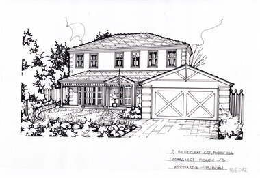
Artwork, other - Ink Line Drawing, Margaret Picken, 2 Silverleaf Crt., Forest Hill, 1996
A property illustration by Margaret Picken Commissioned by the real estate agency Woodards Real Estate Blackburn for the purpose of advertising 2 Silverleaf Crt., Forest Hill. Made by using Rotring ‘Rapidigraph’ drafting pens with Rotring ink on Rapidigraph polyester drafting film, double matte. Trained as a cartographic draftsman within the mining industry, Margaret Picken is an artist who worked producing property illustrations for real estate agencies in eastern suburbs of Victoria from 1983-2005. Retiring from the industry as technological changes favored coloured photography over illustrations, and commissioning companies over sole contractors.This artwork is of Historical Significance as a record of local domestic architecture.A black ink line drawing on drafters film by Margaret Picken, of 2 Silverleaf Crt., Forest Hill, of a two story rendered house setback from a landscaped front garden, with a attached two car garage. There are two hole punch holes near the centre of the upper edge.2 Silverleaf Crt., Forest Hill Picken - 96 Woodards - B/burnwhitehorse historical society, schwerkolt cottage, housing, architecture, margaret picken, house, garden, forest hill, real estate -
 Whitehorse Historical Society Inc.
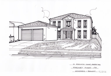
Artwork, other - Ink Line Drawing, Margaret Picken, 10 Echunga Close., Forest Hill, 1994
A property illustration by Margaret Picken Commissioned by the real estate agency Woodards Blackburn for the purpose of advertising 10 Echunga Close., Forest Hill. Made by using Rotring ‘Rapidigraph’ drafting pens with Rotring ink on Rapidigraph polyester drafting film, double matte. Trained as a cartographic draftsman within the mining industry, Margaret Picken is an artist who worked producing property illustrations for real estate agencies in eastern suburbs of Victoria from 1983-2005. Retiring from the industry as technological changes favored coloured photography over illustrations, and commissioning companies over sole contractors.This artwork is of Historical Significance as a record of local domestic architecture.A black ink line drawing on drafters film by Margaret Picken, of 10 Echunga Close., Forest Hill. Depicting on the left foreground a driveway leading to a brick two door garage, on the right a path to a house and front lawn. In the background is a two story brick house. There are two hole punch holes along the top edge.10 Echunga Close., Forest Hill Margaret Picken -94 Woodards - Balwynwhitehorse historical society, schwerkolt cottage, housing, architecture, margaret picken, house, garden, forest hill -
 Whitehorse Historical Society Inc.
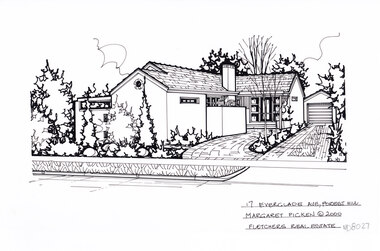
Artwork, other - Ink Line Drawing, Margaret Picken, 17 Everglade Ave., Forest Hill, 2000
A property illustration by Margaret Picken Commissioned by the real estate agency Woodards Blackburn for the purpose of advertising 17 Everglade Ave., Forest Hill Made by using Rotring ‘Rapidigraph’ drafting pens with Rotring ink on Rapidigraph polyester drafting film, double matte. Trained as a cartographic draftsman within the mining industry, Margaret Picken is an artist who worked producing property illustrations for real estate agencies in eastern suburbs of Victoria from 1983-2005. Retiring from the industry as technological changes favored coloured photography over illustrations, and commissioning companies over sole contractors.This artwork is of Historical Significance as a record of local domestic architecture.A black ink line drawing on drafters film by Margaret Picken, of 17 Everglade Ave., Forest Hill. depicting a rendered L shape house with a path and driveway on the left.17 Everglade Ave., Forest Hill Margaret Picken © 2000 Fletchers Real Estatewhitehorse historical society, schwerkolt cottage, housing, architecture, margaret picken, house, garden, forest hill -
 Melbourne Legacy
Document, Branch Chairman's Guide 1991, 1991
A guide for Chairmen of Melbourne Legacy. This copy was owned by Graham Riches. The guide contains: Section A Operations Council and Branches : The Relationship Operations Council Section B Group, Liaison Committee and Groups : The Relationship Group Liaison Committee Section C Internal Changes of Communication and Sources of Information for the Legatee Section D An outline of responsibilities and procedural guidelines for branch chairmen Section E Financial Authority of Branches Section F Guidelines for the Format and Content of Branch Minutes Section G Selection and Appointment of Branch Chairmen Section H Enrolment, Contact and Reporting Procedures Section I Procedure and Notes for Proposers of Prospective Members Section J Duty Legatee Scheme Section K Education (including Sir John Gellibrand Memorial Scholarship and the Macrae Trust) Section L Section M Welfare Section N Pensions, Benefits and Allowances Section O Widows' Committee and Widows' Clubs Section P Widows' Clubs Rules Section Q Current Rates of Social Security and Repatriation Pensions Section R Recommended List of Contractors Available for Home Maintenance (including a list of contractors that can provide services to Widows, such as plumbers, bricklayers, electricians and blind supplies and repairs) 31 yellow pages - not scanned due to it being names and addresses and phone numbers. Section S Administration Instructions An Organisation Chart of Legacy and A Table of Organisation of StaffA living document that was regularly updated for the Chairman of Melbourne Legacy to use in his duties.A4 pages x 64 bound together with split pins.L/GPA Riches in pencil on top edge.regulations, rules, objectives -
 Whitehorse Historical Society Inc.
Document, The 'Mullens House', n.d
Story of the 'Mullens House', originally small dwelling made of hand made bricks by Mrs Mullens' father, Mr Forbes of Glen Waverley. Came from Scotland 93 years ago. As the family increased more rooms were added. Hugh Mullens was a woodcutter and later an orchardist and later still a road contractor. Mrs Tainton, a daughter, still lives in part of the original property. Another daughter, Mrs Stocks who was a widow stayed on with her mother at the old home. It is now the property of Melbourne & Metropolitan Board of Works. Mr & Mrs Hugh Mullen's had 12 children. Mr Mullen's parents lived in Highbury Road, near East Burwood Primary School and were pioneers of East Burwood.hugh, forbes, tainton, r (mrs), stocks, (mrs), melbourne and metropolitan board of works, highbury road, mullen's -
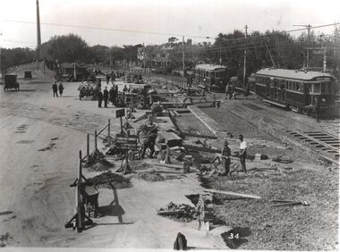 Melbourne Tram Museum
Photograph - Black & White Photograph/s, Melbourne & Metropolitan Tramways Board (MMTB), Jan. 1926
Black and white photograph of the conversion of the intersection of Domain Road, St Kilda Road, Domain Junction from cable tram to electric tram. Shows the Toorak Road Tram remaining trackwork, the temporary track for the electric trams with 276 inbound with the destination of North Coburg and another W class tram outbound to St Kilda Beach. Note the temporary platform and the temporary board crossing. Has "The Foundation Company Engineers and Contractors" sign in the view and the petrol? powered roller. Photo from the Collection of the Department of Infrastructure now with the Public Records Office - image number H101. Note: this photo is now out of copyright and was not an original VR photograph, but one copied from another source and collected as their Heritage series.Has Department of Infrastructure copy right stamp on rear and number "H513" in ink on rear and "2-5".trams, tramways, swanston st, cable trams, trackwork, new tramway, flinders st, conversion