Showing 434 items matching "district road board"
-
 Whitehorse Historical Society Inc.
Newspaper - Article, Watson's heart is in cricket, 17/11/1992
Article in Nunawading Gazette. Fred Watson, cricket umpire with Box Hill Reporter District Cricket Association receives Nunawading Council's Sports Award for 1992.watson, r.a., watson, fred, box hill reporter district cricket association, city of nunawading . sports advisory board -
Whitehorse Historical Society Inc.
Mixed media - Audio Cassette, Denice Moorhouse, 10/02/1996
Cassette - Talk by Denice Moorhouse, given to Nunawading & District Historical Society Meeting on 10th February, 1996.nunawading and district historical society, moorhouse, denice, hetherdale, attc, board of education, vermont school 1022, nunawading roads board, denominational schools board, north nunawading school, richard hurry, david boyle, steele vogel, william burn, miser kay -
 Macarthur & District Historical Society Inc
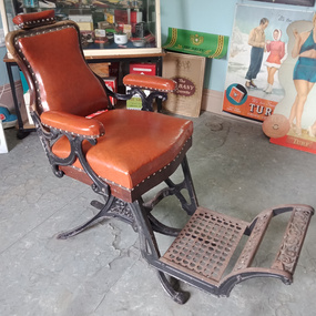
Furniture - Barber's chair
Barber's chair with a detached board for children to sit on, to modify chair height. -
 Mt Dandenong & District Historical Society Inc.
Object, Kyeema Wreckage Fragment, Pre 1938
The Kyeema airline crash took place on 25 October 1938 when the Australian National Airways Douglas DC-2 Kyeema, tail number VH-UYC, flying from Adelaide to Melbourne, commenced final approach to Essendon Airport through heavy fog and crashed into the western slopes of Mount Dandenong, killing all 18 on board instantly. There is strong evidence that the pilots were becoming unsure of their position. According to Macarthur Job's book, Disaster in the Dandenongs, the radio operator had requested the controller at Essendon give them a radio bearing. Essendon had acknowledged and told them to leave their transmitter on, but the signal stopped and no further contact was made. It is thought that this is the moment that Kyeema hit the mountain. There were 18 people on board the DC-2: 14 passengers, the captain, the first officer, an air hostess, and a cadet pilot who operated the radio during the flight. The victims were :— THE CREW. CAPTAIN A. C. D. WEBB, 32, pilot, married, of Essendon, Victoria. JUNIOR CAPTAIN ALAN J. STEEN, 25, pilot, married, of Essendon North, Victoria. ELVA JONES, 27, air hostess, single, of Toorak, Victoria. PHILIP D. PRING, about 20, cadet pilot attached to Australian National Airways' Aeronautics School, Sydney. PASSENGERS. CHARLES ALLAN SEYMOUR HAWKER, M.P., 44, single, of Adelaide. LEONARD SYDNEY ABRAHAMS, K.C., 51, married, barrister, of Sydney. SIDNEY HILL SMITH, 41, married, managing director of S. Smith and Son, of Yalumba, South Australia. ALFRED CECIL GAIN, 42, married, barrister, of Sydney. GORDON H. GODDARD, 30, single, accountant, of North Sydney. LANCELOT WILLIAM SHIRLEY, 27, single, solicitor, of Manly. JAMES IAN MASSIE, 25, single, solicitor, of Sydney. VAUGHAN PATE, 42, refrigeration cabinet manufacturer, married, of Unley, South Australia. THOMAS M. HARDY, 48, married, head of the firm of Thomas Hardy and Sons, vignerons, of Seacliff, South Australia. GEORGE WILLIAM LING, 72, of Kingswood, South Australia, former building inspector of the Municipal Tramways Trust, Adelaide. LOUIS HUGO GRAMP, 43, married, managing director of G. Gramp and Sons, Ltd., vignerons, Rowlands (sic) Flat, South Australia. Mrs. ELIZABETH MARY SCHRADER, 69, widow, of Adelaide. Mr. and Mrs. HANS L. GLOE, of Perth.Small section of the Kyeema DC-2 fuselage made up of 5 pieces of piece of twisted and torn aluminium riveted together. Marking can be seen in red but is indistinct. Aluminium has gold, silver and green colouring.kyeema, a webb, j steen, elva jones, philip pring, charles hawker, leonard abrahams, sidney hill smith, alfred gain, gordon goddard, lancelot shirley, james massie, vaughan pate, thomas hardy, george ling, hugo gramp, elizabeth schrader, mr hans gloe, mrs gloe -
 Mt Dandenong & District Historical Society Inc.
Photograph
The aircraft KYEEMA, a Douglas DC-2, crashed into the western face of Mt Dandenong in thick cloud on 25th October 1938. All 18 occupants on board were killed. The aircraft overshot Essendon Airport by 20 miles. The subsequent findings triggered the beginning of air traffic control and the establishment of the Department of Civil Aviation. This photograph was taken in 1938 by First Constable Carl Tepper of Russell Street Police Station. Carl Tepper was a cousin of Frank Child, grandson of Ted Child. They were related through the Dorey family.Sepia photograph showing the wreckage of an aeroplane spread in the forest amongst trees. Sunlight is streaming through a gap in the trees.On reverse: Wreckage of plane crash in Dandenongs flying daily from Adelaide to Melbourne 1930s. No survivors. Taken by late First Constable Carl Tepper Russell Street Police Station.kyeema, carl tepper, frank child, aircraft, aeroplane, crash site, crash, tepper -
 Mt Dandenong & District Historical Society Inc.
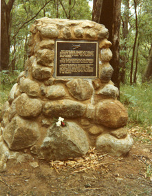
Photograph, Plaque on Kyeema Cairn, 1988
Close up photograph of the plaque on the Kyeema cairn at Mt Dandenong. The text reads: FIFTY METRES BELOW THIS POINT ON 25 OCT. 1938, AUSTRALIAN NATIONAL AIRWAYS' DC-2 'KYEEMA' PLUNGED TO DESTRUCTION WHILE THE MOUNTAIN WAS ENVELOPED IN CLOUD. ALL 18 PERSONS ON BOARD PERISHED. FROM THE RECOMMENDATIONS OF THE SUBSEQUENT ENQUIRY HAVE EVOLVED THE AIR TRAFFIC CONTROL SYSTEMS IN USE THROUGHOUT AUSTRALIA TODAY. THIS PLAQUE, PLACED BY THE MOUNT DANDENONG HISTORICAL SOCIETY, WITH ASSISTANCE FROM G. GRAMP & SONS, THOS. HARDY & SONS, S. SMITH & SON, AUSTRALIAN FEDERATION OF AIR PILOTS AND FORESTS COMMISSION OF VICTORIA, WAS UNVEILED ON 25TH OCT. 1978 TO MARK THE 40TH ANNIVERSARY OF THE DISASTER.kyeema, cairn, plaque, mt dandenong, air crash -
 Mt Dandenong & District Historical Society Inc.
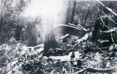
Photograph, Kyeema Crash Wreckage 1938, 1938
Photograph showing twisted metal and broken trees at the site of the Kyeema DC-2 aircraft crash into the western slope of Mt Dandenong on 25th October 1938. All 18 on board perished.kyeema, crash -
 Mt Dandenong & District Historical Society Inc.
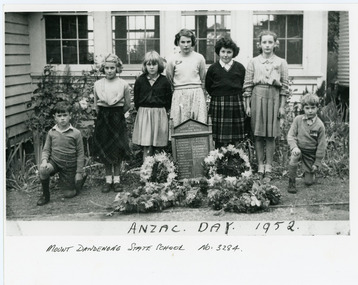
Photograph, ANZAC DAY 1952, 1952
The names of five of the children in the photograph were supplied by Betty Munro after viewing the image on Victorian Collections. L - R: unknown boy, Cynthia Ramage, Betty Munro, Marion Moorby, Frances Barton (nickname 'Bubbles'), Joan Wenborn, unknown boy.Copy of a photograph showing children from Mt Dandenong State School at an ANZAC Commemoration at the school in 1952. There are four girls and three boys standing behind the School WW1 Honour Board that is surrounded by wreaths of flowers.On front of photograph: ANZAC DAY 1952 MOUNT DANDENONG STATE SCHOOL NO: 3284mt dandenong school, anzac, honour board, mt dandenong, mount dandenong -
 Mt Dandenong & District Historical Society Inc.
Photograph, Woolrich Service Car, Between 1917 & 1921
Postcard print showing a Woolrich Service Car with a board attached reading Sassafras & Olinda. George Woolrich started a passenger car service in 1917 with his son Jim. George Woolrich is the driver and his wife Kate Woolrich nee Hand (daughter of early settler Thomas Hand of Kalorama) is seated in the back. The photo would have been taken between 1917 and 1921.service car, woolrich, george woolrich, kate woolrich, kate hand, car, olinda, sassafras -
 Mt Dandenong & District Historical Society Inc.
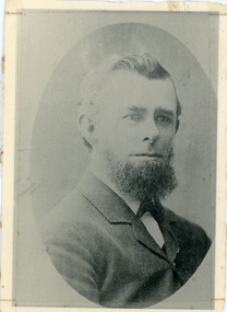
Photograph, Thomas Hand 1839-1888
Copy of a formal photograph showing head and shoulders of Thomas Hand, 1839-1888. This photograph has a detailed inscription on the back handwritten by John Lundy-Clarke in 1974.Thomas Hand 1839-1888 Surveyor for Upper Yarra Road Board 1862-1872. Engineer for Shire of Lillydale 1872-1888. Father of Kate, Eva, Eliza, Florence, Mabel, Alice, Frederick and William. Married Eliza Erith 1862. Owner of “Mountain Grange” in the present district of Kalorama. Copy of photograph in possession of his daughter Mabel made by JLC in 1974. thomas hand, mountain grange -
 Mt Dandenong & District Historical Society Inc.
Photograph, Kyeema Crash Cairn, 1988
Cairn commemorating the crash of the aircraft Kyeema on the western slope of Mt Dandenong on October 25th, 1938. Photograph taken in 1988. Text on plaque reads: FIFTY METRES BELOW THIS POINT ON 25 OCT. 1938, AUSTRALIAN NATIONAL AIRWAYS' DC-2 'KYEEMA' PLUNGED TO DESTRUCTION WHILE THE MOUNTAIN WAS ENVELOPED IN CLOUD. ALL 18 PERSONS ON BOARD PERISHED. FROM THE RECOMMENDATIONS OF THE SUBSEQUENT ENQUIRY HAVE EVOLVED THE AIR TRAFFIC CONTROL SYSTEMS IN USE THROUGHOUT AUSTRALIA TODAY. THIS PLAQUE, PLACED BY THE MOUNT DANDENONG HISTORICAL SOCIETY, WITH ASSISTANCE FROM G. GRAMP & SONS, THOS. HARDY & SONS, S. SMITH & SON, AUSTRALIAN FEDERATION OF AIR PILOTS AND FORESTS COMMISSION OF VICTORIA, WAS UNVEILED ON 25TH OCT. 1978 TO MARK THE 40TH ANNIVERSARY OF THE DISASTER.kyeema, cairn, mt dandenong, air crash -
 Otway Districts Historical Society
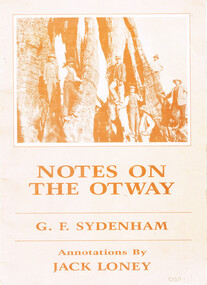
Book, J.K. Loney, Notes on the Otways. G.F. Sydenham, 1987
Notes on the Otways. G.F. Sydenham. J.F. Loney (comp.) 1st ed. J.K. Loney;np; 1987. 36 p.; illus., map. Soft cover. ISBN 0 909191 3 6 0otways; g.f. sydenham; j.k. loney; forests; roads; country roads board; timber; dairying; cape otway lighthouse; -
 Otway Districts Historical Society
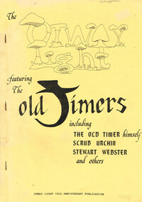
Book, Otway Light Editorial Board, The Otway Light, 1989
A collection of stories from the Otways that were collected for the Otway Light 10th Anniversary publication.The Otway Light featuring the Old Timers, including the Old Timer himself, Scrub Urchin, Stewart Webster, and others. Helen Grant (ed.). Robert Montgomery, Ellise Angel, Claire McCaffie (illus.). Lavers Hill (Vic); Otway Light Editorial Board; 1989. 98 p.; illus. Soft cover.Melba Gully (21st March 1975)otways; stories; sketches; history; -
 Otway Districts Historical Society
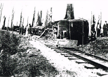
Photograph, Victorian Railways, Derailment at Beech Forest, 1904, 4 October 1904
On Tuesday, 4 October 1904, the first serious railway accident occurred on the Colac-Beech Forest line near Beech Forest. As no train was scheduled that day in the afternoon the crew decided to fetch some wood from down the line. They fired the boiler on locomotive 3A, attached two trucks to the locomotive and moved out of the station. When they arrived opposite the Ditchley Park Hotel they stopped the engine and adjourned to the bar for some refreshments before beginning work. While they were engaged some local children boarded the unattended engine, started it, panicked when it began moving and jumped out leaving in to speed away and tip on a curve in a cutting at Ditchley. The engine was severely damaged. However, its cause remained an Otways secret. The official reason given for the accident is that the driver had fallen out of the engine while engaged in shunting allowing it to run away out of control.Locomotive No. 3A and goods wagons following their derailment at Beech Forest, 4 October 1904.beech forest; railways; narrow gauge; derailment; -
 Bendigo Historical Society Inc.
Document - IAN DYETT COLLECTION: AGENDA OF COUNCIL MEETING
... , Country Roads Board, Bendigo District Cricket Association, YWCA... W Galvin MLA, Country Roads Board, Bendigo District Cricket ...Four page agenda for the next Council Meeting, dated 7th March, 1952. Listed is business and correspondence. Correspondence from S E Beard, A H Pappos, E J Golding, Bendigo Tennis Association, Secretary Home and Family Week, Hon L W Galvin MLA, Country Roads Board, Bendigo District Cricket Association, YWCA Hockey Association, F Ebsary, RACV, Mitchell Popular Girl Committee, Bendigo Free Kindergarten, Dept of Health, Bendigo Football League, Les N Jennings, Education Dept, Secretary for Lands, Music Advancement Society of Bendigo, Cr H McF Cameron, Bendigo Preserving Company, Mrs A P Lyon, Golden City Motors, Mrs E M Taylor, Chamber of Commerce, K E Fischer, Wilson Hall Appeal Committee,business, auctioneers, j h curnow & son pty ltd, ian dyett collection - agenda of council meeting, s e beard, a h pappos, e j golding, bendigo tennis association, hon l w galvin mla, country roads board, bendigo district cricket association, f ebsary, racv, bendigo free kindergarten, dept of health, bendigo football league, les n jennings, education dept, secretary for lands, music advancement society of bendigo, cr h mcf cameron, loddon regional committee, shire of kara kara, bendigo preserving company, mrs a p lyon, golden city motors, mrs e m taylor, chamber of commerce, k e fischer, wilson hall appeal committee, university of melbourne -
 Kew Historical Society Inc
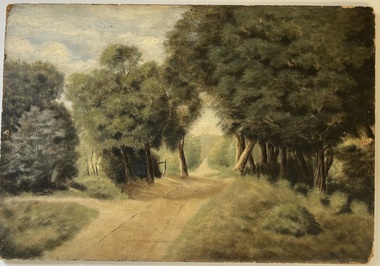
Painting - Country Road, Frankston, Hubert C McDonald
The French Collection was donated to the Society in 2022. This collection includes documents, artworks, books, costumes and artefacts belonging to two families. A number belonged to, or were made by the grandparents of the donor: Vera May Wing and her husband Hubert Charles McDonald. [Other items belonging to Vera and Hubert are in the collections of the Australian Performing Arts Museum and Museum Victoria.] A second significant group of objects were gifts made to the donor's family by Lucy (Jean) Hornby of Queen Street, Kew whose family had been early settlers in the district.Gift of Anna French, 2022Frankston country road. Oil on composite board by Hubert Charles McDonald.Reverse: "HC McDonald / Frankston"artworks, frankston, hubert c mcdonald -
 Kew Historical Society Inc
Photograph, Floods in North Kew, 1971
Living with natural processes was frequently a challenge to early European settlers and later residents of what was in the 1850s administered by the Borondara Road Board. This was compounded by the area being bounded on three sides by rivers (Yarra River, Koonung Creek and Gardiner's Creek). In 1849, the historian James Bonwick recorded that "our district [Kew] suffered considerably. Mr Wade speaks of 80 acres, out of 100 acres of his cultivated paddock, covered by water." Newspapers continued to describe major flooding in Kew in 1863, 1869, 1878, 1880, 1889, 1891, 1916 and 1934. While the construction of the Upper Yarra dam in 1957 reduced the levels of flowing downstream, local and riverine floods continue.The Kew Historical Society's pictures and map collections testify to the impact of flooding in the district. They have historical importance in documenting the extent of flooding in the district and its affects on homes, services and recreation. Numerous photographs record flooding throughout the Twentieth Century.Floods in North Kew, 1971. Looking northeast towards Kilby Road from River Avenue. Annotation on reverse: map and date "8 Nov. 71 10.30am".floods (kew), yarra river, kew flood, kilby road flood -
 Kew Historical Society Inc
Photograph, Floods in North Kew, 1934
Living with natural processes was frequently a challenge to early European settlers and later residents of what was in the 1850s administered by the Borondara Road Board. This was compounded by the area being bounded on three sides by rivers (Yarra River, Koonung Creek and Gardiner's Creek). In 1849, the historian James Bonwick recorded that "our district [Kew] suffered considerably. Mr Wade speaks of 80 acres, out of 100 acres of his cultivated paddock, covered by water." Newspapers continued to describe major flooding in Kew in 1863, 1869, 1878, 1880, 1889, 1891, 1916 and 1934. While the construction of the Upper Yarra dam in 1957 reduced the levels of flowing downstream, local and riverine floods continue.The Kew Historical Society's pictures and map collections testify to the impact of flooding in the district. They have historical importance in documenting the extent of flooding in the district and its affects on homes, services and recreation. Numerous photographs record flooding throughout the Twentieth Century.Floods in North Kew, 1934. Vicinity of Willsmere Park.floods (kew) -
![Flooding at Chipperfield's Boathouse [East Kew], 1934](/media/collectors/550653872162f11fb04854aa/items/58cbaad5d0cec425b474bfb1/item-media/58cf6fbdd0cf9f331490feb0/item-fit-380x285.jpg) Kew Historical Society Inc
Kew Historical Society IncPhotograph, Flooding at Chipperfield's Boathouse, 1934
Living with natural processes was frequently a challenge to early European settlers and later residents of what was in the 1850s administered by the Borondara Road Board. This was compounded by the area being bounded on three sides by rivers (Yarra River, Koonung Creek and Gardiner's Creek). In 1849, the historian James Bonwick recorded that "our district [Kew] suffered considerably. Mr Wade speaks of 80 acres, out of 100 acres of his cultivated paddock, covered by water." Newspapers continued to describe major flooding in Kew in 1863, 1869, 1878, 1880, 1889, 1891, 1916 and 1934. While the construction of the Upper Yarra dam in 1957 reduced the levels of flowing downstream, local and riverine floods continue.The Kew Historical Society's pictures and map collections testify to the impact of flooding in the district. They have historical importance in documenting the extent of flooding in the district and its affects on homes, services and recreation. Numerous photographs record flooding throughout the Twentieth Century.Floods in North Kew, 1934. Chipperfield's Boathouse and the adding Moorings was located beside the Yarra River near the corner of Willsmere and Kilby Roads. The flood reached the roof of the Moorings, which can be seen in the photo.floods (kew), floods (kew) 1934, yarra river -
 Kew Historical Society Inc
Photograph, Floods in North Kew, 1934
Living with natural processes was frequently a challenge to early European settlers and later residents of what was in the 1850s administered by the Borondara Road Board. This was compounded by the area being bounded on three sides by rivers (Yarra River, Koonung Creek and Gardiner's Creek). In 1849, the historian James Bonwick recorded that "our district [Kew] suffered considerably. Mr Wade speaks of 80 acres, out of 100 acres of his cultivated paddock, covered by water." Newspapers continued to describe major flooding in Kew in 1863, 1869, 1878, 1880, 1889, 1891, 1916 and 1934. While the construction of the Upper Yarra dam in 1957 reduced the levels of flowing downstream, local and riverine floods continue.The Kew Historical Society's pictures and map collections testify to the impact of flooding in the district. They have historical importance in documenting the extent of flooding in the district and its affects on homes, services and recreation. Numerous photographs record flooding throughout the Twentieth Century.Floods in North Kew, 1934. Unidentified location on the Yarra Flood Plain at Kew.floods (kew) 1934, yarra river -
 Kew Historical Society Inc
Photograph, Floods in North Kew, 1934
Living with natural processes was frequently a challenge to early European settlers and later residents of what was in the 1850s administered by the Borondara Road Board. This was compounded by the area being bounded on three sides by rivers (Yarra River, Koonung Creek and Gardiner's Creek). In 1849, the historian James Bonwick recorded that "our district [Kew] suffered considerably. Mr Wade speaks of 80 acres, out of 100 acres of his cultivated paddock, covered by water." Newspapers continued to describe major flooding in Kew in 1863, 1869, 1878, 1880, 1889, 1891, 1916 and 1934. While the construction of the Upper Yarra dam in 1957 reduced the levels of flowing downstream, local and riverine floods continue.The Kew Historical Society's pictures and map collections testify to the impact of flooding in the district. They have historical importance in documenting the extent of flooding in the district and its affects on homes, services and recreation. Numerous photographs record flooding throughout the Twentieth Century.Floods in North Kew, 1934. Chipperfield's Boat House under flood.floods (kew) 1934, yarra river, chipperfield's boat house -
 Kew Historical Society Inc
Photograph, Floods in North Kew, 1934
Living with natural processes was frequently a challenge to early European settlers and later residents of what was in the 1850s administered by the Borondara Road Board. This was compounded by the area being bounded on three sides by rivers (Yarra River, Koonung Creek and Gardiner's Creek). In 1849, the historian James Bonwick recorded that "our district [Kew] suffered considerably. Mr Wade speaks of 80 acres, out of 100 acres of his cultivated paddock, covered by water." Newspapers continued to describe major flooding in Kew in 1863, 1869, 1878, 1880, 1889, 1891, 1916 and 1934. While the construction of the Upper Yarra dam in 1957 reduced the levels of flowing downstream, local and riverine floods continue.The Kew Historical Society's pictures and map collections testify to the impact of flooding in the district. They have historical importance in documenting the extent of flooding in the district and its affects on homes, services and recreation. Numerous photographs record flooding throughout the Twentieth Century.Floods in North Kew, 1934. Flood near the lagoon (Billabong?)floods (kew) 1934, yarra river -
 Kew Historical Society Inc
Photograph, Chipperfield's Boat House & Floating Pontoon, 1934
Living with natural processes was frequently a challenge to early European settlers and later residents of what was in the 1850s administered by the Borondara Road Board. This was compounded by the area being bounded on three sides by rivers (Yarra River, Koonung Creek and Gardiner's Creek). In 1849, the historian James Bonwick recorded that "our district [Kew] suffered considerably. Mr Wade speaks of 80 acres, out of 100 acres of his cultivated paddock, covered by water." Newspapers continued to describe major flooding in Kew in 1863, 1869, 1878, 1880, 1889, 1891, 1916 and 1934. While the construction of the Upper Yarra dam in 1957 reduced the levels of flowing downstream, local and riverine floods continue. A number of boat houses operated on both sides of the River Yarra at Kew. Chipperfield's Boat House was located on the Yarra near the corner of Kilby and Willsmere Roads.The Kew Historical Society's pictures and map collections testify to the impact of flooding in the district. They have historical importance in documenting the extent of flooding in the district and its affects on homes, services and recreation. Numerous photographs record flooding throughout the Twentieth Century.Floating pontoon at Chipperfield's Boat House where the canoes were stored, taken in 1934, presumably before the 1934 Flood. This area of the Yarra was shallow with a number of mid river sandbanks and a popular swimming area for locals.yarra river, chipperfield's boathouse, pontoon -
 Trentham and District Historical Society
Photograph, Buffalo Head Hotel 2014, Photo taken in 2014
The Buffalo Head Hotel was the location of the first Tylden Kyneton Roads BoardPhotos of site of Buffalo Head Hotel taken in 2014trentham, tylden, kyneton, hotel, road board, -
 Port Fairy Historical Society Museum and Archives
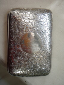
Award - cigar case, c. 1901
On 30th August 1901 The Chronicle, an Adelaide newspaper, announced that J.W.Hosking was leaving Terowie to establish a business in Port Fairy. He had lived in Terowie for 25 years and had been chairman of the District Council, a member of the school board and a Justice of the Peace. He was also a keen supporter of the cricket and other sporting teams. On leaving Treowie he was presented with a Gladstone bag and an illuminated address signed by 47 residents. Hosking had a wife and daughter and it was reported that with his brother, he had bought the drapery and furnishing business of W.T.Hattam in Port Fairy. Trading as G.E.Hosking &Co., the brothers already had branches in N.S.W. South Australia and Western Australia. By 1905 J.W.Hosking was President of the Port Fairy Hospital and, although in July of that year he announced that he was resigning because of pressure of business, he was obviously persuaded to stay on. Indeed, he remained President until 1907. In September 1907, the brothers were bought out by D.E.MacLellan, late of MacLellan & Craig of Mount Gambier. So when the silver cigar/cigarette case was presented to Hosking, he was not only ceasing to be President of the Hospital but was almost certainly leaving the town. On February 1908 he resigned as a JP for the Western Bailiwick of the State of Victoria.Typical of the type of item given to express gratitude for voluntary work especially in positions such as Presidents and Secretaries.silver cigar case, chased hall marked, interior gold washto J W Hosking Esq/ from the Committee/Port Fairy Hospital/14/11/07civic mementoes, presentations, hospital, hosking, g.e.hosking&co, port fairy, president, jp, western bailiwick, state of victoria, demaclellan, wthattam -
 City of Greater Bendigo - Civic Collection
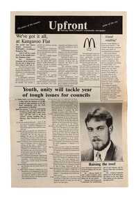
Newspaper, Shire of Marong, Upfront, c 1989
Marong was first incorporated as a road district on 27 August 1861, and became a shire on 23 December 1864. On 1 October 1915, the Borough of Raywood, which was gazetted on 17 January 1865 on 23.31 square kilometres of land 28 kilometres north of Bendigo was united with Marong. On 1 October 1990, the Shire of Marong became a rural city, under the Local Government Act 1989. In a report on 17 February 1994, the Local Government Board recommended that the five councils in the Bendigo region merge to form a "super city", with a population of about 81,000. Marong, Eaglehawk and Huntly had earlier objected to the proposal, and the Board noted a weak no vote against the merger proposal in a referendum in the region; about 70% had voted against, but with a turnout of between 30% and 40% of eligible voters. The three councils filed a writ in the Supreme Court, alleging failure to follow process by the Minister for Local Government, Roger Hallam, but by the time the new "super city" was announced, the writ had not yet been heard, and on 24 March 1994, the Rural City of Marong successfully applied for an injunction blocking the publication of the gazette the following day abolishing the five councils and appointing three commissioners. The government responded by introducing legislation, the City of Greater Bendigo Bill 1994, to Parliament, to effectively override the Supreme Court action, with Hallam saying "the bill would make clear that the Government is determined to achieve its objective for a more efficient municipal structure for the Bendigo region." Marong mayor Robert Hynes described the action as "terribly disappointing", adding, "One way or another, I believe it does mean an end to our fight... it seems the Government are above the law to me." On 6 April 1994, Marong voted to drop the Supreme Court action, effectively in doing so voting itself out of existence, and on 7 April 1994, the Rural City of Marong was abolished, and along with the City of Bendigo, the Borough of Eaglehawk and the Shires of Huntly and Strathfieldsaye, was merged into the newly created City of Greater Bendigo. On 29 April 1994, the Minister confirmed the Bill was not being proceeded with. https://en.wikipedia.org/wiki/Rural_City_of_MarongEight page newspaper style council newsletter providing community updates, news and information. shire of marong, city of greater bendigo amalgamation, councillor phillip eddy, rural city of marong -
 Royal District Nursing Service (now known as Bolton Clarke)
Photograph - Photogtaph, Portrait, black and white, c.1970
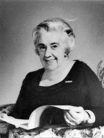
This photograph is a visual record of Mrs. Hallenstein who was President of Royal District Nursing Service (RDNS) from 1967-1974. In February 1970 the Royal District Nursing Service (RDNS) hosted the First International Congress on Domiciliary Nursing and, as President of RDNS, Mrs. Hallenstein presided over the opening ceremony. Mrs. Hallenstein played an integral roll in the planning and correspondence to the College of Arms, London, which concluded with the Royal District Nursing Service being granted a Coat of Arms in 1970. In 1949 Mrs. D. (Elsa) Hallenstein was elected as a member of the Committee of Management of the Melbourne District Nursing Society (MDNS) and After-Care Hospital, and In 1951 was elected as a member of the Committee of Management, and appointed to the Board of Directors of the Nursing Service Division, of MDNS and After-Care. In 1957 when the Society and After-Care Hospital separated, Mrs. Hallenstein was on the first Committee of Management of the now Melbourne District Nursing Service whose Headquarters was located at 452 St. Kilda Road, Melbourne. In 1962 she was elected as a Vice-President and in 1964 as senior Vice-president of MDNS until 1967 when she became President of the Committee of Management of the now renamed Royal District Nursing Service (RDNS), a role she held until 1974. In February 1970 RDNS hosted the First International Congress on Domiciliary Nursing and, as President, Mrs. Hallenstein presided over the opening ceremony. Mrs. Hallenstein played an integral roll in Melbourne District Nursing Service being granted Royal patronage in 1966, now becoming Royal District Nursing Service (RDNS), and with the planning and correspondence to the College of Arms, London, which concluded with the Royal District Nursing Service being granted a Coat of Arms in 1970. Black and white photograph of the head and shoulder view of Mrs. D. (Elsa) Hallenstein, who has light coloured wavy short hair. She is smiling and is wearing a black frock with small brooch attached. She is sitting in a floral lounge chair and has an open white leaflet in her hands.melbourne district nursing society, mdns, melbourne district nursing service, royal district nursing service, rdns, rdns coat of arms, mrs d. (elsa) hallenstein -
 Royal District Nursing Service (now known as Bolton Clarke)
Photograph - Photograph, colour, c.1980
Sister McLean is attending a function in the RDNS Board room at 452 St. Kilda Road, Melbourne. She worked in RDNS Headquarters. The RDNS insignia on the upper left of her uniform tunic has the words "Royal District Nursing Service" written in white in the blue circle. Across the centre of the circle are two clasping hands depicted in yellow..From its founding in 1885 until 1891, the Trained nurses (Nurses) of the Melbourne District Nursing Society (MDNS) worked from their own homes which were located in the vicinity of their areas (districts). Their Committee meetings were held at the Religious Tract Society Rooms, No 3 Queen's walk, off Swanston Street and later at the Library Room in the Melbourne Town Hall. The Annual General Meetings were held in the Town Hall. In November 1891 MDNS was able to rent a two story terraced house at 66 Cardigan Street, Carlton, at £65 a year, which contained accommodation for three Trained nurses (Nurse) and one pupil nurse as well as being used as their Headquarters. They left from their Nurses Home each morning and returned at the end of their shift to write up their book work before retiring for the day. Three years later they moved into a larger terraced house at 49 Drummond Street Carlton which was rented at ‘a very moderate rental’. There was a Board room, apartments for the Nurses and pupil nurses, a large dispensary which patients could attend each evening to have prescriptions signed and bottles refilled with ‘homely remedies’ and elixirs, which were administered for e.g. to Consumptive cases. Doctor’s prescriptions were filled at the Pharmacy. Cupboards containing donated blankets and bedclothes for needy patients were kept in this room, and it was here where the Nurses kept their nursing bags which were refilled at the end of each shift ready for any emergency and for the next day. A list of Doctors the Nurses could call was kept by the telephone. The home also had a kitchen where nourishing soup was made and distributed twice a week to the needy. Milk was also distributed when needed. In 1902 they moved into rented premises at 188 Leicester Street, Carlton and two years later, in 1904, to premises at 5 Royal Terrace, Nicholson Street, Fitzroy where they remained for ten years. In June 1914 at last the Society had sufficient funding to purchase their own terraced premises, ‘Floraston’ 39 Victoria Parade, Collingwood which was their Headquarters and Nurses Home. In 1926 the After-Care Home for recovering patients, (later called After-Care Hospital) was built by the Society next door, running from 41-47 Victoria Parade (became No. 45); the District nurses continued to live at No. 39. In November 1953 the District Nursing Division moved into their new Headquarters and Nurses Home at 452 St. Kilda Road, Melbourne but as the Service expanded into the suburbs Centres were opened and their Trained nurses (Sisters) worked from home, so the Nurses Home section of 452 was closed and turned into more administrative areas. In 1996 Headquarters were relocated to 31 Alma Road, St. Kilda.Coloured photograph of the upper view of Sister Kath McLean of the Royal District Nursing Service (RDNS) who has short straight dark hair and is smiling as she sits holding a cake on a white plate. She is wearing her RDNS winter uniform; a grey skivvie under a blue/grey herringbone woolen V neck tunic style frock with a central zip. On its upper left It has the RDNS insignia of a round blue circle with writing on it, surrounded on either side by white swept up feathers towards the central crown above the circle. Under this is her name plate and a gold coloured medal. A pen is clipped into the left hand V neck section of the frock. rdns, royal district nursing service, rdns winter uniform, rdns board room, rdns headquarters, kath mclean -
 Royal District Nursing Service (now known as Bolton Clarke)
Photograph - Photograph, colour, c.1980
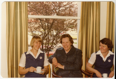
The RDNS Sisters are attending a functions being held in the Board Room at RDNS Headquarters, 452 St. Kilda Road in Melbourne.From its founding in 1885 until 1891 the trained nurses of the Melbourne District Nursing Society (MDNS) worked from their own homes which were located in the vicinity of their areas (districts). The Committee meetings were held at the Religious Tract Society rooms at Queen’s walk, off Swanston Street and then at the Library Room at the Melbourne Town Hall. The Annual General Meeting was held at the Town Hall. In November 1891 MDNS was able to rent a two story terraced house at 66 Cardigan Street, Carlton, at £65 a year, which contained accommodation for three Trained nurses (Nurses) and one pupil nurse as well as being used as their Headquarters. They left from their Nurses Home each morning and returned at the end of their shift to write up their book work before retiring for the day. Three years later they moved into a larger terraced house at 49 Drummond Street Carlton which was rented at ‘a very moderate rental’. There was a Board room, apartments for the Nurses and pupil nurse, a large dispensary which patients could attend each evening to have prescriptions signed and bottles refilled with ‘homely remedies’ and elixirs, which were administered for e.g. to Consumptive cases. Doctor’s prescriptions were filled at the Pharmacy. Cupboards containing donated blankets and bedclothes for needy patients were kept in this room, and it was here where the Nurses kept their nursing bags which were refilled at the end of each shift ready for any emergency and for the next day. A list of Doctors the Nurses could call was kept by the telephone. The home also had a kitchen where nourishing soup was made and distributed twice a week to the needy. Milk was also distributed when needed. In 1902 they moved into rented premises at 188 Leicester Street, Carlton and two years later, in 1904, to premises at 5 Royal Terrace, Nicholson Street, Fitzroy where they remained for ten years. In June 1914 at last the Society had sufficient funds to purchase their own terraced premises, ‘Floraston’ 39 Victoria Parade, Collingwood which was their Headquarters and Nurses Home. In 1926 the After-Care Home for recovering patients, (later called After-Care Hospital) was built by the Society next door, running from 41-47 Victoria Parade (became No. 45); the District nurses continued to live at No. 39. In November 1953 the District Nursing Division moved into their new Headquarters and Nurses Home at 452 St. Kilda Road, Melbourne. As RDNS expanded with Centres now opening throughout the suburbs, their Trained nurses (Sisters) lived in their own homes and the Nurses Home at 452 closed and the rooms used for administrative purposes. On April the 1st 1996 RDNS Head Office relocated to 31 Alma Road, St. Kilda.Colour photograph of Royal District Nursing Service (RDNS), Sisters who are standing in a room - left to right - .....Pat (Paddy) Rowley, with short brown hair and wearing glasses, Kath McLean, with short dark hair, Betty Harris, who is wearing glasses and with short brown curly hair and on the far right Ruth May, wearing glasses and with short dark hair, Sister May and the unknown Sister on the far left hand side, are wearing the RDNS summer uniform of a white blouse under a V neck royal blue tunic style frock. The three Sisters in the centre of the photograph are wearing the RDNS winter uniform of blue/grey skivvies under their blue/grey herringbone woollen V neck tunic style frocks. The RDNS insignia is on the upper left of the uniforms. Opened gold long curtains are in the background, along with three wooden chairs which have green backs and seats. The chairs are partly hidden by the standing Sisters. A vase of plumed feather flowers is behind Sr. Harris. Part of a white clothed table, with silver cutlery and white plates on it, is the the foreground.rdns, royal district nursing service, rdns uniform, rdns headquarters, sister ruth may, sister kath mclean, sister pat (paddy) rowley, sister betty harris -
 Royal District Nursing Service (now known as Bolton Clarke)
Photograph - Photograph, colour, c.1980
The photograph is taken at a function in the Board Room of RDNS Headquarters, 452 St. Kilda Road, Melbourne. Miss Mary Evans was the RDNS Director of Nursing from 1963-1978,From its founding in 1885 until 1891, the Trained nurses (Nurses) of the Melbourne District Nursing Society (MDNS) worked from their own homes which were located in the vicinity of their areas (districts). The Committee meetings were held at the Religious Tract Society rooms at Queen’s walk, off Swanston Street and then at the Library Room at the Melbourne Town Hall. The Annual General Meeting was held at the Town Hall. In November 1891 MDNS was able to rent a two story terraced house at 66 Cardigan Street, Carlton, at £65 a year, which contained accommodation for three Nurses and one pupil nurse as well as being used as their Headquarters. They left from their Nurses Home each morning and returned at the end of their shift to write up their book work before retiring for the day. Three years later they moved into a larger terraced house at 49 Drummond Street Carlton which was rented at ‘a very moderate rental’. There was a Board room, apartments for the Nurses and pupil nurse, a large dispensary which patients could attend each evening to have prescriptions signed and bottles refilled with ‘homely remedies’ and elixirs, which were administered for e.g. to Consumptive cases. Doctor’s prescriptions were filled at the Pharmacy. Cupboards containing donated blankets and bedclothes for needy patients were kept in this room, and it was here where the Nurses kept their nursing bags which were refilled at the end of each shift ready for any emergency and for the next day. A list of Doctors the Nurses could call was kept by the telephone. The home also had a kitchen where nourishing soup was made and distributed twice a week to the needy. Milk was also distributed when needed. In 1902 they moved into rented premises at 188 Leicester Street, Carlton and two years later, in 1904, to premises at 5 Royal Terrace, Nicholson Street, Fitzroy where they remained for ten years. In June 1914 at last the Society had sufficient funds to purchase their own terraced premises, ‘Floraston’ 39 Victoria Parade, Collingwood which was their Headquarters and Nurses Home. In 1926 the After-Care Home for recovering patients, (later called After-Care Hospital) was built by the Society next door, running from 41-47 Victoria Parade (became No. 45); the District nurses (Sisters) continued to live at No. 39. In November 1953 the District Nursing Division moved into their new Headquarters and Nurses Home at 452 St. Kilda Road, Melbourne. As RDNS expanded and now, with Centres opening throughout the suburbs, the Sisters lived in their own homes and the Nurses Home at 452 closed and those rooms used for administrative purposes. On April the 1st 1996 RDNS Head Office relocated to 31 Alma Road, St. Kilda. Coloured photograph taken at a function in a room at Royal District Nursing Service (RDNS). It shows, left to right, Sister Bev Armstrong, who has short blonde hair, Miss Mary Evans, who has short curled brown hair and another RDNS Sister who has short dark hair. The two RDNS Sisters are wearing the RDNS summer uniform of a white blouse under a royal blue V neck tunic style dress with the RDNS insignia on the left hand side. Miss Evans, is wearing a long dark coat. The three are smiling and the Sister on the right is looking at Miss Evans who is turned slightly and has part of her right arm resting over the top of the back of the chair. They are sitting in front of a window and opened gold long curtains. A tree is seen through the window. Both RDNS Sisters have cups in their hands.royal district nursing service, rdns, rdns headquarters, miss mary evans, sister bev armstrong