Showing 6777 items
matching gully
-
 Eltham District Historical Society Inc
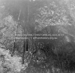
Album - Photograph, J.A. McDonald, Healesville-Yarra Glen Road, Aug. 1958
Long Gully Bridge August 1958Record of various Shire of Eltham infrastructure works undertaken during the period of 1952-1962 involving bridge and road reconstruction projects, sometimes with Eltham Shire Council Project Reference numbers quoted. It was during this period that a number of significant improvements were made to roads and new bridges constructed within the shire that remain in place as of present day (2022). In many situations, the photos provide a tangible visible record of infrastructure that existed throughout the early days of the Shire. The album was put together by or under the direction of the Shire Engineer, J.A. McDonald.infrastructure, shire of eltham, 1958-08, bridge construction, long gully bridge, road construction -
 Bendigo Historical Society Inc.
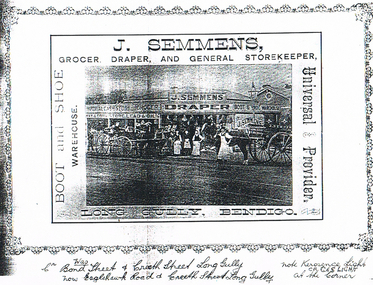
Document - LONG GULLY HISTORY GROUP COLLECTION: J SEMMENS
Black and white photocopy of a photo of J. Semmens, Grocer, Draper, and General Storekeeper, Long Gully, Bendigo. Photo shows the store with the name, J Semmens, Grocer, Draper, Boot and Shoe Warehouse. In front of the shop is a number of people and two horse drawn vehicles. Written under the photo is: Cr was Bond Street & Creeth Street Long Gully, now Eaglehawk Road & Creeth Street, Long Gully. Note - Kerosene Light or Gas Light at Corner.bendigo, history, long gully history group, the long gully history group - j semmens, j semmens draper -
 Stawell Historical Society Inc
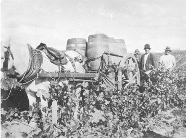
Photograph, Grape Picking in Great Western 1902
B/W photo of three men with a white horse pulling a cart with barrels of grapes just picked. Taken at Arrawatta Vineyard at Irvine's, Great western near Jonathon Gully and German Gully Roads. 1902win, wineries -
 Bendigo Historical Society Inc.
Document - MCCOLL, RANKIN AND STANISTREET COLLECTION: SHARE REGISTER GARDEN GULLY & MOON EXTENDED GOLD MINE
Share register journal Garden Gully and Moon extended Gold Mine. Green cover, buff spine and corners. Contains names and addresses of shareholders 1933 to 1934. Alphabetical list of shareholders in front of journal. Written on spine: Garden Gully Moon Extended Gold Mines NL.business, mining, garden gully and moon extended nl mines -
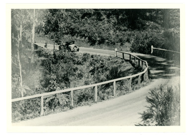 Mt Dandenong & District Historical Society Inc.
Photograph
An old fashioned car can be seen pulling away from a bend on the new CRB Road at Wallaby Gully (now Mt Dandenong Tourist Road). Wallaby Gully is near the Mt Dandenong kindergarten. The year is c1926.Black and white photograph showing a car rounding a bend on a road surrounded by bush and fenced with a wooden rail fence.crb road, kindergarten, car, mt dandenong tourist road, wallaby gully -
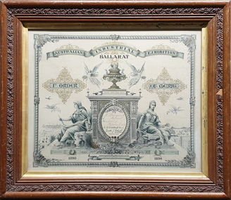 Federation University Historical Collection
Certificate, Australian Juvenile Exhibition Ballarat Certificate, 1896, 1896
The certificate was designed by David Kent in 1896Timber framed certificate relating to the Australian Juvenile Exhibition Ballarat and awarded to William Baragwanath for the model of the Welcome Gully. Frame is by W.H. Burgoyne, Picture Frame Maker, artist, Castlemainecertificate, w.h. burgoyne, william baragwanath, c.b. retallack, joseph j. kelsall, david kent, rider and mercer -
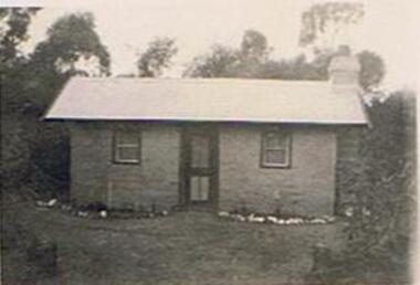 Bendigo Historical Society Inc.
Photograph - COOK COLLECTION : BENDIGO FIELD NATURALISTS CLUB - COTTAGE
Cottage. Photo, black and white. Inscriptions: back, E A Cook, 231 Carpenter Street, Spring Gully, Bendigo.buildings, house, cottage -
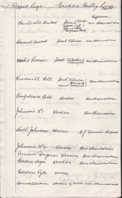 Bendigo Historical Society Inc.
Document - CARLISLE UNITED MINE - POPPET LEGS OF THE GARDEN GULLY LINE
Hand written notes on the poppet legs of the Garden Gully Line. Lists the mines and if the poppet legs are steel or wooden.mine, gold, carlisle, carlisle united mine, poppet legs of the garden gully line -
 Bendigo Historical Society Inc.
Newspaper - JACK PERRY COLLECTION: NEWSPAPERDIAMOND HILL, STAFFORD MINE, WATER WHEEL
Newspaper article Bendigo Weekly. Mentions Diamond Hill and Golden Gully, Phillips Water Wheel, Stafford Mine.person, individual, jack perry - diamond hill, diamond hill, phillips water wheel -
 Bendigo Historical Society Inc.
Map - LONG GULLY HISTORY GROUP COLLECTION: LONG GULLY
Copy of a map of Long Gully area with some street names, size of allotments, number, measurements, date and names.bendigo, history, long gully history group, the long gully history group - long gully, housing commission, housing act 1958, gazette -
 Bendigo Historical Society Inc.
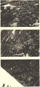
Photograph - LONG GULLY HISTORY GROUP COLLECTION: AERIAL PHOTOS
Copies of three dark aerial photos of suburban areas, possibly Long Gully. Photos show streets and buildings.bendigo, history, long gully history group, the long gully history group - aerial photos -
 Bendigo Historical Society Inc.
Map - GUIDE MAP OF BENDIGO & EAGLEHAWK, Late 1920's
Map. Guide Map of Bendigo & Eaglehawk. Light brown coloured booklet containing folded map of Bendigo and Eaglehawk. Outer cover is printed in blue and red ink and states - With compliments of J H Curnow & Son, Auctioneers, Real Estate Agents, Farm & Dairy Produce Merchants, Bendigo. Printed by J B Young, Lithographer. Map shows tramways & bus routes. Map shows Agricultural Showgrounds located between Park Street, Water Street, Barnard Street and Bridge Lane. Also shows Acclimitization Reserve located behind The Botanical Gardens at White Hills. Shows the location of Sailors Gully, Peg-Leg Gully, Jobs Gully, California Gully, Long Gully, Ironbark Gully, Golden Gully, Poverty Gully, Sheepshead Gully, Charcoal Gully, Eaglehawk Creek, Bendigo Creek and Back Creek. Contains interesting facts about Bendigo - Area 7,900 acres. Population - 26,000. First Council elected - 1855. Proclaimed a Borough - 1863. Proclaimed a City - 1871. Gold Rush broke out - 1851. For first 10 years gold yield averaged 8,600 ozs. per week . Total gold yield to 1923 - 572 tons valued at 82,000,000 pounds. Deepest mines - Victoria Quartz 4,614 ft., New Chum Railway 4,318 ft. 13 mines over 3.000 ft. deep. 53 mines over 2,000 ft. deep. Sewering of City commenced 1922, all principal buildings now sewered. Map printed by Arnall & Jackson, General Printers, Stationers & Engravers, 476 Collins Street. Map displays advertisement for J H Curnow & Son, Bendigo's leading Auctioneer and Estate Agents, Mitchell & Queen Sts. Bendigo. Map Scale 20 chs. = 1 in.cottage, miners, guide map of bendigo and eaglehawk -
 Bendigo Historical Society Inc.
Map - GUIDE MAP OF BENDIGO & EAGLEHAWK, Late 1920's
Map. Guide map of Bendigo & Eaglehawk. Folded map of Bendigo & Eaglehawk with blue outer cover booklet. Map is compiled by E E Parker, Eaglehawk. Map shows tramways, bus routes and cost one shilling. Map shows Agricultural Showgrounds located between Park Street, Water Street, Barnard Street and Bridge Lane. Also shows Acclimitization Reserve located behind the Botanical Gardens at White Hills. Shows the location of Sailors Gully, Peg-Leg Gully, Jobs Gully, California Gully, Long Gully, Ironbark Gully, Golden Gully, Poverty Gully, Sheepshead Gully, Charcoal Gully, Eaglehawk Creek, Bendigo Creek and Back Creek.Contains interesting facts about Bendigo:- Area - 7,900 acres, Population - 26,000, First Council elected - 1855, Proclaimed a City - 1871. Gold Rush broke out - 1851. For first 10 years gold yield averaged 8,600 ozs. Per week. Total gold yield to 1923 - 572 tons valued at 82,000,000 pounds. Deepest mines - Victoria Quartz 4,614 ft., New Chum Railway 4,318 ft., 13 mines over 3,000ft. deep, 53 mines over 2,000 ft. deep. Sewering of City commenced 1922. All principal buildings now sewered. Map printed by Arnall & Jackson, General Printers, Stationers & Engravers, 476 Collins Street. Outer map blue cover printed in red and blue ink by J B Young, Lithographer. Map displays advertisement for Bendigo Timber Co. Outer blue cover displays advertisement for Campbell Connelly & Co. Pty. Ltd, Ironmongers, Timware Manufacturers, Plumbers, Sewerage Contractors, High and Forest Sts, Bendigo 9outside back cover) and for Hartleys ( J L Shoosmith) Bendigo, displaying Indian Motor Cycles (inside back cover).map, bendigo, township, guide map of bendigo & eaglehawk -
 Bendigo Historical Society Inc.
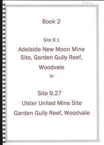
Book - ADELAIDE NEW MOON MINE GARDEN GULLY REEF WOODVALE TO ULSTER UNITED MINE SITE, WOODVALE, 1992
Book 2 - Site 9.1, Adelaide New Moon Mine site, Garden Gully Reef, Woodvale to site 9.27, Ulster United Mine Site, Garden Gully Reef, Woodvale. Book contains details of significance reports prepared for North Central Goldfields Project: Bendigo Goldfield.David Bannearbendigo, mining, goldfields report, bendigo, goldfields, gold, mining, reports, history -
 Bendigo Historical Society Inc.
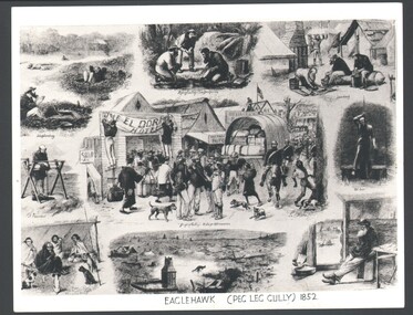
Photograph - WES HARRY COLLECTION: PEG - LEG GULLY, Original from 1852
Photograph of a montage of nine drawings depicting life during the first gold rush to Peg Leg Gully (Eaglehawk) during 1852. On the reverse in pencil is written ' Gold rush in Peg Leg Gully, The lightning rise and fall of an old gold town. A concise history of Australia, By Clive Turnbull.topic, mining, fist gold rush, gold rush, peg leg gully, eaglehawk -
Bendigo Historical Society Inc.
Booklet - Glittering Gullies
1. Dorothy Dempsey was a student of Arthur Thomas Woodward (see No.2). She was considered a "promising artist" who exhibited in Bendigo and Melbourne in the late 1930's - early 1940's. The Bendigo Art Gallery has one of her paintings. 2. Arthur Thomas Woodward (1865, Birmingham, England- 12/2/1943 Bendigo) Studied and taught art in England, Paris and Antwerp before coming to Victoria in 1889. Whilst briefly the Art Director of the Sale School of Art, he married Emma Jane Stokes in 1892. He then became the Head of the Art Department at the Bendigo School of Mines, where he remained until his retirement in 1921. He was responsible for the art division of the Victorian Gold Jubilee Exhibition. and was heavily involved in the establishment of the Bendigo Art Gallery. He lived at "The Roselands", View Street, where he also conducted private art lessons after his retirement.Beige soft cover booklet of 32 pages. Titled 'Glittering Gullies' a compilation of 15 B&W sketches by Dorothy Dempsey of mining scenes and buildings. Inside is a loose card of a handwritten invitation to the announcement of the publication of 'Glittering Gullies.' Dorothy Dempsey was a student of Arthur T Woodward, Bendigo. mining gullies, bendigo -
 Bendigo Historical Society Inc.
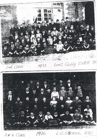
Photograph - LONG GULLY HISTORY GROUP COLLECTION:LONG GULLY STATE SCHOOL PHOTOS 1933 AND 1936
Photocopy of two photos on a page. The first is 1 & 2 Class 1933 Long Gully State School taken outside a brick building. Two boys in the front row are holding a black board with Long Gully School Grades I & II written on it. The Second photo the 3 & $ Class 1936. L. G. S School 2120. Two boys in the front row are holding a black board with Long Gully School Grades III & IV 1936 written on it. the photo is very dark.bendigo, history, long gully history group, the long gully history group - long gully state school photos 1933 and 1936 -
Bendigo Historical Society Inc.
Book - THE GOLDEN VALLEY, 1980
32 page soft cover booklet 'The Golden Valley - An account of the Wattle Gully Area.' An account of the rehabilitation of the Wattle Gully Mine, illustrated with colour photos. Booklet prepared to commemorate the reopening of the mine by Rupert Hamer, Premier of Victoria in 1980. On page 15 is a handwritten note in biro 'To Ray Wallace - I had great pleasure in researching, photographing & preparing all the information here - this was a limited edition publication for shareholders of Wattle Gully in 1980 Regards Felix Cappy' Author and publisher not givenUnknown -
 Eltham District Historical Society Inc
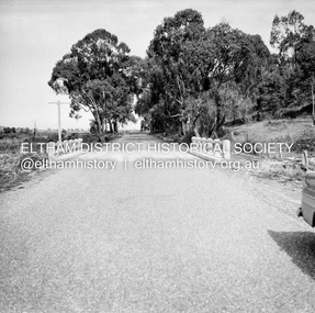
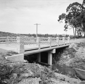
Negative - Photograph, J.A. McDonald, Healesville-Yarra Glen Road, Sep 1959
Long Gully Bridge after reconstruction September 1959Record of various Shire of Eltham infrastructure works undertaken during the period of 1952-1962 involving bridge and road reconstruction projects, sometimes with Eltham Shire Council Project Reference numbers quoted. It was during this period that a number of significant improvements were made to roads and new bridges constructed within the shire that remain in place as of present day (2022). In many situations, the photos provide a tangible visible record of infrastructure that existed throughout the early days of the Shire. The album was put together by or under the direction of the Shire Engineer, J.A. McDonald.infrastructure, shire of eltham, bridge construction, 1959-09, healesville-yarra glen road, long gully bridge -
 Eltham District Historical Society Inc
Negative - Photograph, J.A. McDonald, Healesville-Yarra Glen Road, Sep 1959
Long Gully Bridge after reconstruction September 1959Record of various Shire of Eltham infrastructure works undertaken during the period of 1952-1962 involving bridge and road reconstruction projects, sometimes with Eltham Shire Council Project Reference numbers quoted. It was during this period that a number of significant improvements were made to roads and new bridges constructed within the shire that remain in place as of present day (2022). In many situations, the photos provide a tangible visible record of infrastructure that existed throughout the early days of the Shire. The album was put together by or under the direction of the Shire Engineer, J.A. McDonald.infrastructure, shire of eltham, bridge construction, 1959-09, healesville-yarra glen road, long gully bridge -
 Bendigo Historical Society Inc.
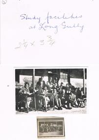
Photograph - LA TROBE UNIVERSITY BENDIGO COLLECTION: LONG GULLY STATE SCHOOL
One black and white photo of Bendigo Teachers' College students using the study facilities at Long Gully State School. There is also a proof and negative of same. These three items are in a white envelope on which is written Study Facilities at Long Gully. The number 2 is written on the left hand corner of the envelope.bendigo, education, long gully state school, la trobe university bendigo collection, collection, bendigo teachers' college, bendigo, tertiary education, primary schools, long gully state school, state schools, negative, place, buildings, schools, bendigo teachers' college students, students, photo, photograph, photographs, photography -
 Bendigo Historical Society Inc.
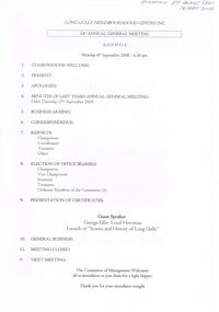
Document - LONG GULLY NEIGHBOURHOOD CENTRE ANNUAL GENERAL MEETING NOTES: SEPTEMBER 2008, 8th Sept, 2008
Long Gully Neighbourhood Centre Inc 24th Annual General Meeting Agenda Document. Monday 8th September 2008 at 6:30 pm. Donated by Mr James Lerk Guest Speaker For The Night George Ellis Local Historian Launch of 'Stories and History of Long Gully.' 12 pages.clubs and associations, history, long gully neighbourhood centre, http://lgnc.org.au/ -
 The Beechworth Burke Museum
Photograph, 1907-8
The photo from 1907-8 is a sepia print, depicting a small valley with building at base. There are flumes visible above areas of water, trees on hills and a few small cottages on the hillside. Cock's Pioneer Gold & Tin Sluicing Co NZ No 2 Site. The photo was taken of Matthews Gully looking west. Sluicing was undertaken in the area from 1900 to 1942 with some short breaks between these periods. The image depicts a location mined by Cocks Pioneer Gold and Tin Sluicing Company (as recorded on the annotation on the card mount) The Cocks Pioneer Gold and Tin Mines N.L was one of El Dorado's two largest open cut sluicing mines of the 20th Century. The other was named the Cocks El Dorado Gold Dredging Company. The Cocks Pioneer Mines operated from 1901 until 1941 and found a total of 117,378 ounces of Gold and 1,673 tones of tin concentrates over these years. The Cocks company was formed in 1898 and operated until 1941. Open cut sluicing involved the use of high-powered hoses which used the centrifugal sand pump system (known as hydraulic sluicing) which broke down the soil which was then processed for gold and other precious metals. From 1914 , four years after this image was captured, the company reformed to Cocks Pioneer Gold and Tin Mines NL (previously it was known as Cocks Pioneer Sluicing Co) and undertook large scale sluicing operations until 1929 and then 1934-1941. El Dorado is located on Reedy Creek and is surrounded by forested country to the north and east. It is 20 km east of Wangaratta in Victoria's regional north-east. John Cock was the son of a Cornish minor who arrived in El Dorado in 1858. Cock founded his gold and tin mining company which ran successfully for many years in the El Dorado region. It was an open cut sluicing company because of the abandonment of underground mining after this was deemed too dangerous. In 1935 Cock's El Dorado Company commissioned the floating dredge which is still visible in El Dorado today. The dredge was built by the Thompson engineering works, Castlemaine, and weighed over 2,000 tones and today has a place on the Victorian Registers of historic buildings. Interestingly, the name El Dorado does not derive from the gold in the region, but from the Barambogie pastoral run completed by William Baker in 1840-1841. Gold was discovered in El Dorado 1854 but the gold was too deep for individual prospectors to find, it required the use of heavy machinery.The search for gold is ingrained into the history of Victoria and therefore, images like this one which portray an open cut sluicing site can reveal important information for society and technology for the date when the photograph was taken. This image is of important historical significance for its ability to convey information about sluicing and the methods used to find gold in 1910. It also shows a location where sluicing was undertook which provides insight into the impact of sluicing on the environment at a time when it was done. This image is important for current research into the history of El Dorado, a small regional location near Wangaratta in Victoria's North East. Therefore, this image has the capacity to be beneficial for research into society and the motivations of those living and working in this region during this period and therefore, has social significance. The Beechworth Burke Museum has additional images relating to gold sluicing and El Dorado which can be analysed and studied alongside images like this one.Sepia coloured rectangle photograph printed on gloss photographic paper Reverse: 1997. 2613/ A02613/ No2 site/ Matthews Gully/ Cocks Pioneer G&T. ?? Co NZ/ No2 Site looking West/ 1907-8/ (7)sluicing, hydraulic sluicing, 1907, 1908, mining, cock's pioneer gold & tin sluicing co nz, nz, site no 2, matthews gully, west, valley, building, cottages, hillside, trees, water, gold and tin mine -
 Marysville & District Historical Society
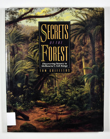
Book - Paperback book, Secrets of the Forest-Discovering history in Melbourne's Ash Range, 1992
A history of Melbourne's Ash forestsPaperback. Front cover has a painting on it. The painting is "Ferntree Gully in the Dandenong Ranges, 1857", painted by Eugene von Guerard.Tom Griffiths with assistance from the Historic Places Branch,/ Department of Conservation and Environment, Victoria,/ and the Monash Public History Group Stamp of the Marysville & District Historical Society Inc / P.O. Box 22 / Marysville 3779historic site, victoria, ash range, history, griffiths, tom -
 Marysville & District Historical Society
Book - Paperback book, Secrets of the Forest-Discovering history in Melbourne's Ash Range, 1992
A history of Melbourne's Ash forestsPaperback. Front cover has a painting on it. Painting is "Ferntree Gully in the Dandenong Ranges, 1857", painted by Eugene von Guerard.Tom Griffiths with assistance from the Historic Places Branch,/ Department of Conservation and Environment, Victoria,/ and the Monash Public History Group Stamp of the Marysville & District Historical Society Inc / P.O. Box 22 / Marysville 3779historic site, victoria, ash range, history, griffiths, tom -
 Marysville & District Historical Society
Book, Secrets of the Forest-Discovering history in Melbourne's Ash Range, 1992
A history of Melbourne's Ash forestsPaperback. Front cover has a painting on it. Painting is "Ferntree Gully in the Dandenong Ranges, 1857", painted by Eugene von Guerard.Stamp of the Marysville & District Historical Society Inc / P.O. Box 22 / Marysville 3779historic site, victoria, ash range, history, griffiths, tom -
 Marysville & District Historical Society
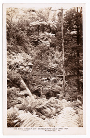
Postcard (item) - Black and white postcard, Rose Stereograph Company, Cumberland-Cora Lynn Trip, Marysville, Vic, 1913-1967
A postcard in a series produced by the Rose Stereograph Company in Victoria, Australia as a souvenir of Marysville.A black and white photograph of a view up a gully in the Cumberland Valley in Victoria. The Cumberland Valley is home to both the Cumberland and Cora-Lynn Falls. It is also home to the Big Tree, a huge Mountain Ash tree which, at one time, was the tallest hardwood tree in the world. The Cumberland Valley is a short drive from Marysville.POST CARD The "Rose" Series/ De Luxe A Real Photograph/ Produced in Australia Published by the Rose Stereograph Co.,/ Armadale, Victoria.cumberland valley, cora lynn falls, marysville, victoria, walking track, p. 4970, rose series postcard, postcard, souvenir, cumberland falls, the big tree, mountain ash -
 Marysville & District Historical Society
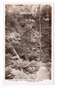
Postcard (item) - Black and white postcard, Rose Stereograph Company, Cumberland-Cora Lynn Trip, Marysville, Vic, 1913-1967
A postcard in a series produced by the Rose Stereograph Company in Victoria, Australia as a souvenir of Marysville.A black and white photograph of a view up a gully in the Cumberland Valley in Victoria. The Cumberland Valley is home to both the Cumberland and Cora-Lynn Falls. It is also home to the Big Tree, a huge Mountain Ash tree which, at one time, was the tallest hardwood tree in the world. The Cumberland Valley is a short drive from Marysville.POST CARD The "Rose" Series/ De Luxe A Real Photograph/ Produced in Australia Published by the Rose Stereograph Co.,/ Armadale, Victoria.cumberland valley, cora lynn falls, marysville, victoria, walking track, p. 4970, rose series postcard, postcard, souvenir, cumberland falls, the big tree, mountain ash -
Bendigo Historical Society Inc.
Document - Digital, KEN BICE COLLECTION: MINER'S RIGHT FRANK BICE
Copy of document, Miner's Right issued to Frank Bice of Maiden Gully, on 28/9/1949. This is a digital only document.cottage, miners, miner's right, bendigo, bice, mining -
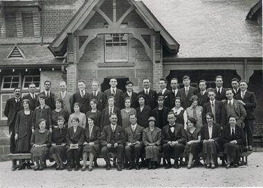 Bendigo Historical Society Inc.
Photograph - LA TROBE UNIVERSITY BENDIGO COLLECTION: BENDIGO TEACHERS' COLLEGE STUDENTS
Two black and white photographs of Bendigo Teachers' College staff and students in front of Long Gully State School in 1926.bendigo, education, bendigo teachers' college students, la trobe university bendigo collection, collection, bendigo teachers' college collection, education, bendigo, bendigo teachers' college students, bendigo teachers' college staff, long gully state school, schools, teaching, teachers, photo, photograph, photographs, photography, tertiary education, teacher training