Showing 1033 items
matching gums
-
 4th/19th Prince of Wales's Light Horse Regiment Unit History Room
Drill rounds, .303 inch, c 1905
Used by Victorian Light Horse 1906As used by Australian Light HorseClip of 5 .303" drill rounds in charger. Rounds - brass cases with holes drilled in them to show that they are inert, bullet component made of red gum. Old type Enfield steel charger clip"E" stamped on charger -
 Halls Gap & Grampians Historical Society
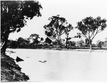
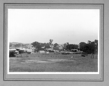
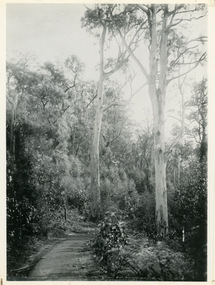
Photograph - B/W, c 1844
This property was known as Mokepilly Station ( name on back of photo is spelt 'Mokepilli'.For further reference see p.2,p.92,116,119,121, Victoria's Wonderland.Photo shows a body of water in foreground with a collection of buildings on opposite bank. there are a number of large gum trees on both sides of water. The buildings appear to be a farmhouse and outbuildings that have thatched roofs. There is extensive fencing.buildings, houses -
Tatura Irrigation & Wartime Camps Museum
Photograph - copy, Dhurringile Mansion Stables, 1977
Copy of original photograph, Courtyard of stables, store rooms, pay office for original Dhurringile Mansion.Black and white photograph of Mr J. Lowry in courtyard of old stables built in 1902 with red gum chopping block, the dome of the underground tank which was 20 feet deep and 18 feet in diameter.jack lowry, dhurringile stables -
Tatura Irrigation & Wartime Camps Museum
Photograph, Corrugated huts
Black and white photograph of two corrugated huts joined at right angles. Brick chimney, brush fence curved oval top, gum tree behind the centre right angle bend road in foreground -
Tatura Irrigation & Wartime Camps Museum
Tray, 1940's
Made by internee at Camp 3, TaturaSuperb serving tray - heavy border. Handle end on left : map of Australia and Kangaroo. Handle end of right : map of Australia and Kookaburra Gum leaves (6) on stem marked on Centre Camp| Taturatray, kangaroo, kookaburra, lorence a, gratz a, camp 3, tatura, ww2 camp 3, handcrafts, woodcarving -
 Whitehorse Historical Society Inc.
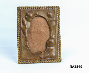
Decorative object - Picture Frame
Leather tooled picture frame with laced edged edge, oval centre for picture, tooled around edge. Has picture of Gum nut babies. See Na2848 for the type of tools used to decorate this frame.handcrafts, leatherworking, trades -
Clunes Museum
Memorabilia - LAPEL PIN
.1 Lapel pin in the shape of a slouch hat with feathers. Pin is mounted on card depicting soldiers on horseback .2 Lapel pin in shape of two gum leaves. Pin is mounted on card depicting soldiers.1 1914-1918 is engraved on semi circle below the slouch hatlapel pin, gum leaves, slouch hat -
 National Wool Museum
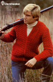
Booklet - Pattern Booklet, Cleckheaton Design 0051, Cleckheaton, 1980s
Four page fold out knitting pattern booklet featuring a colour image on the cover of a man crouching in the grass with a bow and arrow. The man is wearing a green knitted jumper, blue pants and gum boots.front: [printed] Cleckheaton / 8/12 PLY / Design 0051 / 8 Ply Sizes: 89 - 119 cm / 12 Ply Sizes: 86 - 107 cmknitting, pattern, fashion, knitwear, cleckheaton -
 National Wool Museum
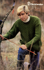
Booklet - Pattern Booklet, Cleckheaton Design 0050, Cleckheaton, 1980s
Four page fold out knitting pattern booklet featuring a colour image on the cover of a man crouching in the grass with a bow and arrow. The man is wearing a green knitted jumper, blue pants and gum boots.front: [printed] Cleckheaton / 8/12 PLY / Design 0050 / Sizes: 86 - 112 cmknitting, pattern, fashion, knitwear, cleckheaton -
 Melbourne Tram Museum
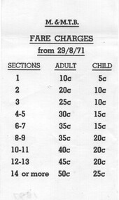
Document - Form/s, Melbourne & Metropolitan Tramways Board (MMTB), "Fares Changes from 29/8/1971", Aug. 1971
Small slip or printed paper or form detailing the Adult and Child fares to apply from 29/8/1971 for each Section. Has a gummed section on the rear of the form for adhering to the Fares and Sections book.trams, tramways, tickets, fares, sections -
 Greensborough Historical Society
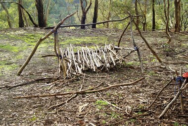
Photograph - Digital image, Marilyn Smith, Blue Lake: Makeshift camp-site, 19/06/2015
Blue Lake is in Yellow Gum Park in the Plenty Gorge, north of Greensborough. These photos show a makeshift camp site in the park.Digital copy of colour photographsyellow gum park, blue lake, plenty gorge park -
 Rutherglen Historical Society
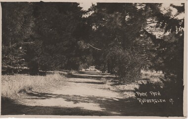
Image, Park Path Rutherglen 17, c1890
Path shown is on the western side of Lake King, Rutherglen. The pine trees have been replaced with river red gums.Black and white postcard photograph showing a path through and avenue of trees.Printed at bottom right of photo: "Park Path Rutherglen 17" Message written on back of card: "Dear Alban | Just a card to wish you the complements of the season. I've been so busy that I've not had time to write, so excuse this short note. Hoping you and yours are in the best of health as we are also. I am your affectionate cousin Olga"rutherglen park, lake king -
 Eltham District Historical Society Inc
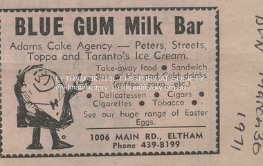
Document - Property Binder, 1006 Main Road, Eltham, 1971
Newspaper advertisement: Leader Associated Newspapers, Eltham Centenary Supplement, March 30, 1971 Blue Gum Milk Bar property, businesses, main road eltham, blue gum milk bar (eltham) -
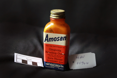 City of Moorabbin Historical Society (Operating the Box Cottage Museum)
Manufactured Glass, brown bottle 'AMOSAN', 20thC
Amosan is an oral wound cleanser manufactured in Belgium and sold under the Oral-B brand, belonging to Procter & Gamble after its recent acquisition of Gillette (2005). It is used to aid in the prevention of as well as speed the recovery from canker sores, denture irritation, orthodontic irritation, and oral injuries or after dental procedures. It is distributed in a powdered form that requires reconstitution with warm water, after which it is used as a mouth rinse. It is customarily packaged in 1.7 g envelopes and sold in boxes of 20 packets each. Active ingredient: Sodium perborate monohydrate 1.2 g Oral-B discontinued manufacture c 2011 A brown glass bottle with a metal screw top containing a small amount of powder. 'AMOSAN'Front label : AMOSAN / For the treatment of / GINGIVITIS / BLEEDING GUMS / AND FOR THE RELIEF OF / THE IRRITATION OF / SORE THROAT / ECONOMY SIZE / MADE IN AUSTRALIA FOR / THE KNOX DRUG COMPANY / DISTRIBUTORS / MELBOURNE SYDNEY pharmacy, medicines, gingivitis, glassware, bottles, moorabbin, bentleigh, cheltenham, belgium, proctor & gamble ltd, gillette ltd, dentists, orthodontics, dentures -
 Linton and District Historical Society Inc
Photograph, Linton landscape - view from the school, looking to south-east
Undated black and white photograph, which mostly shows buildings in Sussex Street, Linton, near the corner of Sussex and Clyde Streets. Surrey Street can be seen in the foreground but there are no houses along it."View of Linton from school. Large tree gum planted was in front of cottage dad built when they were first married. Now half covered with ivy". "(16)".sussex street linton, surrey street linton -
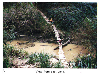 Eltham District Historical Society Inc
Work on paper (Sub-Item) - Photograph, Home-made footbridge across Diamond Creek, opposite Gum Glade, Eltham
Colour photograph of home-made footbridge across the Diamond Creek opposite Gum Glade, Eltham. View from east bank.eltham, diamond creek, footbridge, gum glade -
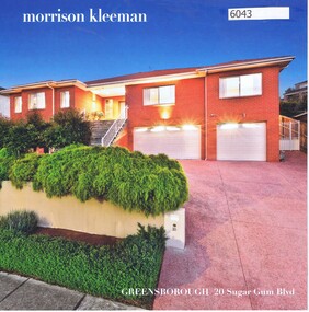 Greensborough Historical Society
Advertising Leaflet, 20 Sugar Gum Boulevard Greensborough, 05/09/2017
20 Sugar Gum Boulevard Greensborough. 4 bedroom house. October 2017 for $1,210,000. Previous sales: September 2005 for $325,000.Real Estate advertising leaflet,1 sheet folded into 4 pages, printed in colour both sides.sugar gum boulevard greensborough -
Port Melbourne Historical & Preservation Society
Tool - Ruler, City of Port Melbourne Electricity Supply Department, 1980s - 1990s
Given together with 972.03 and a lemon-scented gum seedling to Pat Grainger when she was naturalised at the Port Town Hall in 199230 cm yellow ruler stamped with 'City of Port Melbourne Electricity Supply Department'utilities - electricity, immigration -
Port Melbourne Historical & Preservation Society
Tool - Pen, Ballpoint, City of Port Melbourne and Borough by the Bay, 1980s - 1990s
Given together with 972.02 and a lemon-scented gum seedling to Pat Grainger when she was naturalised at the Port Town Hall in 1992Red and blue plastic ballpoint pens stamped with the City of Port Melbourne and 'Borough by the Bay'immigration -
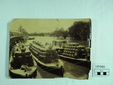 Port of Echuca
Photograph, P.S. Rodney with barges Horace & Nelson, c.1890
P.S Rodney with barges Horace & Nelson laden with wool bales bought into the Port to be unloaded onto rail trucks to go to markets in Melbourne. c.1890 Paddlesteamers travelled the river systems to bring wool from out- lying properties into the Port of Echuca to be transported by rail to Melbourne. This was prior to road & rail transport in the 1800'sOne of thousands of photos taken depicting the transportation of wool from out- lying properties to the rail head at Port of Echuca using paddlesteamers. P.S.Rodney alongside barges Horace & Nelson, tied to historic Echuca Wharf, with Pride of the Murray paddlesteamer & barge in back ground all vessels loaded with wool bales and crew resting on these. Riverbank lined with red gums. Handwritten in pen on lower left back corner "Rodney with barges Horace & Nelson c. 1890"farming, economy, p s rodney, port of echuca, wool bales, wharf, barges, horrace, nelson, paddlesteamer rodney, echuca -
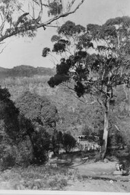 Halls Gap & Grampians Historical Society
Photograph - B/W, C ?
This is the ford over the Stoney Creek and shelter shed.The photo shows a track leading down to a large pergola type structure, surrounded by thick bush. There is a tall gum on the right of the picture, beside the track. A large branch of a tree can be seen in the top left foreground.access routes, roads -
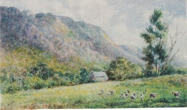 Halls Gap & Grampians Historical Society
Photograph - Coloured
Painting is by Will Rees, an Australian Artist. Subject is a shepherd's hut owned by the D Alton Family on land where D'Alton's Resort now stands.Item is a coloured print of a painting. The range stands in the back ground. A hut stands middle of foreground with a stump in front . A taller gum tree stands to the right side of the photo. Print has soft muted colours.painting, landscape -
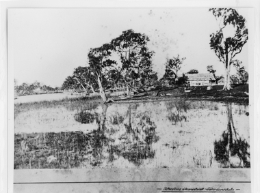 Halls Gap & Grampians Historical Society
Photograph - B/W, c 1869
Photo is said to be of Schoolers' homestead,Lake Lonsdale. Miss Scouller was the teacher at Halls Gap Primary school in 1921.Spelling of Schooler varies from that on front of photo to 'Scouller' which appears in book "Bridging the Gap'.Photo shows bark roofed building on a bank of a body of water . A number of large gum trees surround the buildings-- tree reflections can be seen in the water. There appears to be extensive fencing around the buildings. The homestead is not visible.buildings, houses -
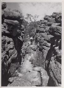 Halls Gap & Grampians Historical Society
Photograph - B/W, C 1960s
Photo is of area known as ' Silent Street'. It is on path to Pinnacle Lookout.Photo shows a man walking along slabs of rock that form a path between rocky outcrops. He is walking away from the camera. Various shrubs line the path. Gum trees can be seen in background.'Copyright photograph'. This photograph may be reproduced on condition that it is acknowledged as 'Victorian Railways Photograph', p3456- Silent Street . Halls Gap.scenery, wonderland range -
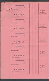 Bendigo Historical Society Inc.
Document - CAMBRIDGE PRESS COLLECTION: RECEIPT - A. I. POOLE
Sheet of five pink receipt forms with a sheet of yellow backing paper. Receipts in the name of A. I. Poole, Berriwillock. Date line ends 19--. Has space for 2d Duty Stamp if Necessary. Gummed back.business, printers, cambridge press, cambridge press collection, a i poole -
 El Dorado Museum Association Inc.
Photograph (item) - Digital Image
Cocks Pioneer Electric Gold & Tin Mine Company was formed in 1899. The company's first power station, located at the eastern end of the valley began operating with its 340 Kilowatt steam-powered generator. By 1909, from 2,500,000 cubic yards worked, reported recovery was 17,284 ounces of gold and 224 tons of tin ore. By 1909, Cocks Pioneer’s power plant had become inadequate and uneconomical. The barge was floated downstream about a mile, but lost time caused the operations to cease. Following testing, a new mine was established by diverting Reid's Creek at a cost of £25 000. Settling dams were built, one of which held 1,935,900 cubic feet. Sold earth banks, built against a wall of stringy bark saplings constructed and laced with vertical props, were built. In 1914, the company was reformed as Cock’s Pioneer Gold and Tin Mines NL, another power station was constructed at the western end of the township, near the junction of Clear and Reid's Creeks. From 6,800,000 cubic yards of material processed, the returns were 64,397 ounces of gold and 855 ton of tin. Cocks Pioneer mine then moved the barge downs stream and continued sluicing. In 1929 Cocks Pioneer Electric Gold and Tin Mining Company ceased operations due to a drop in values. Cock’s Pioneer Gold and Tin Mines NL carried on large-scale hydraulic sluicing operations until 1941. mining, mines, gold, tin, gold mining, tin mining, sluicing, cocks pioneer, el dorado, eldorado -
 Victorian Apiarists Association
Publication, 1st Australian Bee Congress, October 13-16, 1972
Just over A5 size soft cover book. Aqua cover with picture of Mugga Ironbark flowering on the front, colourful map of Australia on the back with honeycomb on it & surrounded by Australian birds on flowering gums 239 pagesThis volume was published under the guidance of - Prof. Dr. Eng. V Harnaj - President of Apimondia John Guilfoyle - President of the First Australian Bee congress Dr. Francis Smith - Editor of the scientific papers -
 Mt Dandenong & District Historical Society Inc.
Photograph, Jasper Road Near Erith Lane 1920, 1920
View of Jasper Road, near Erith Lane taken in 1920. The road is tree lined with two significant gum trees in the foreground. This photograph has a detailed inscription on the back handwritten by John Lundy-Clarke in 1974.Jasper Road near Erith Lane 1920. This road has only a narrow right of way. It was put in as a road to serve “Cherry Farm”, connecting it to the Coach Road at the Elbow in 1904. It joins a wide surveyed road running from Inverness Road to the Coach Road at the Elbow and could possibly have been surveyed by Thomas Hand at the same time as Inverness Road. The name Jasper now applies to full length between Erith Lane and Coach Road. McGivern Bros widened it in 1937 and J L Clarke removed and stored much of the rock quarried in the widening. This was later sold to Dick Moorby who sold it to the builders of St Michaels Church in Falls Road. Comment by John Lundy-Clarke 10.5.1974 jasper road, erith lane, john lundy-clarke -
Bendigo Historical Society Inc.
Ephemera - LYDIA CHANCELLOR COLLECTION: CRUISE SHIP MENU, 1962
LYDIA CHANCELLOR COLLECTION: CRUISE SHIP Menu Front Cover Colour print of Koala in a gum tree and mountains in the background. Inside: Drins and Food Menus. Enroute Auckland to Suva Thursday May 31 1962 -
 Sunbury Family History and Heritage Society Inc.
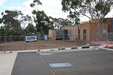
Photograph, Rosa McCall, 2nd January 2018
The former Sunbury Library was demolished and the empty site is ready for the construction of the new library. The existing building housed the George Evans Museum. A more modern Global Learning Centre is planned to be built on the site.A coloured photograph of a fenced site with a flat-roofed cream brick building adjacent to an area that has a been cleared in preparation for construction. A demolition sign is attached to the wire fence. Gum trees are growing in three background.libraries, global learning centre, sunbury, hume city council, macedon street, sunbury library