Showing 4549 items matching "historical maps"
-
 Eltham District Historical Society Inc
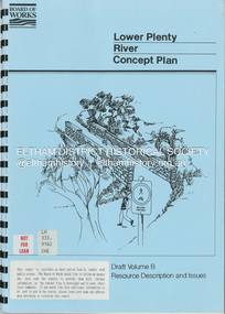
Book, Brett Cheatley et al, Lower Plenty River Concept Plan; Maroondah Pipetrack - Greensborough to Yarra/Plenty Confluence; Draft Volume B, Resource Description and Issues, February 1991
concept plan, melbourne metropolitan board of works, plenty river, report -
 Eltham District Historical Society Inc
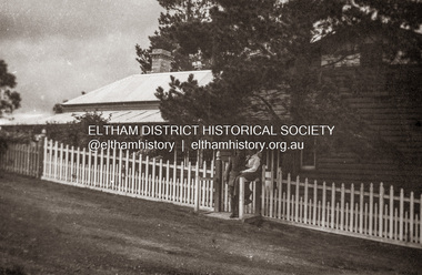
Photograph, Sgt Tyrrell George Evans with fiancee, Mary Pitt Withers outside the Withers family home, Southernwood, Bolton Street, Eltham, c.1917
Present day Google Street View https://goo.gl/maps/PZZMoEdJYUXbgf4a8 Tyrrell George Granville Evans was born on 17th August 1892 Enlisted (No. 789) 7 July 1915 as a Private and was assigned to the 31st Battalion. Promoted to Sergeant 1 Nov 1915. Disembarked Suez 7 Feb 1916 Admitted to 32nd Stat. Hospital in France 21 July 1916 with a gunshot wound to the left arm. According to daughter-in-law, Janet Evans, on 19 July 1916, in the battle near Pozieres on the Somme, he was hit by a German high explosive shell and was unconscious and badly wounded. His left arm was shattered, and he had a bullet wound on his leg. Embarked at Boulogne on H.S. Cambria for Middlesex War Hospital, England 24 July 1916. Evans returned to Australia and was discharged medically unfit, 7 April 1917. After months in the Caulfield Hospital his arm could not be saved, and it was amputated 18 July 1917. On July 6, 1918, Tyrrell George Granville Evans married Mary Pitt Withers at Eltham, daughter of artist Walter Herbert Withers (deceased) and wife Fanny (nee Flinn). They had three children, Mary Roberta Evans born February 8, 1921, at Balwyn and twins Shirley and Joyce born June 10, 1922. Mary died 17 days later, June 27, 1922, at Balwyn. Tyrrell had to cope with three children under three years old and a missing left arm. He had been lefthanded before his war injuries. He had help from the family, especially his sister. On August 1, 1924, Tyrrell George Granville Evans married Marian Frances Wilcox and they had two children: Barbara Marian, born 27 July 1925 and Tyrrell Granville, born 3 July 1928. The children were all brought up together in Glen Iris. Tyrrell became renowned as a one-armed golfer and tennis player. He was Senior Vice-President of the Lawn Tennis Association of Victoria and was on the committee of the Metropolitan Golf Club. At the time of his retirement, he was General Manager of the Colonial Meat Company. Tyrrell died September 3, 1962 and was succeeded by sixteen grandchildren. Contributed to by Janet Evans (daughter-in-law), 27 May 2024Many items in this collection have suffered from significant water damage and black mouldjohn withers collection, eltham, tyrrell george granville evans, mary pitt withers, 1917, bolton steet, scan - 620 format 6x9 negative, southernwood -
 Eltham District Historical Society Inc
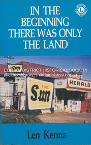
Book, Len Kenna, In the beginning there was only the land, 1988
A book, published as part of the Australian Bicentenary Celebrations on the history of the suburb of Bundoora. ... Includes photographs, maps and index. Local history of the outer Melbourne suburb of Bundoora, from the original Wurundjeri people through to its development as a thriving suburb in the 1980s ; section entitled "The Aborigines" (pp.14-21) discusses the traditional way of life of the Wurundjeri people prior to European settlement.bundoora, bundoora hall, hospitals, jane mckimmie, janefield, janefield church, john mckimmie, la trobe university, marvellous melbourne, mont park, mont park psychiatric hospital, plenty river, william shillinglaw, wurundjeri, yan yean reservoir -
 Eltham District Historical Society Inc
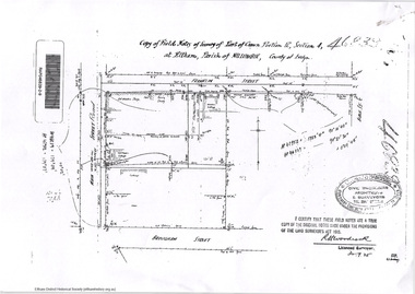
Document - Photocopy, Survey Fleld Notes of Part of Crown Portion 13, Section 4 at Eltham, Parish of Nillumbik, County of Evelyn, 1902-1903
Main Road, Henry Street to Diamond Street; Silver Street to Bible Street Application No. 0337771902, 1903, arthur street, bible street, bird street, diamond creek (creek), diamond street, eltham, eltham railway station, henry street, main road, silver street, survey plan, vine street, application 33777, map -
 Eltham District Historical Society Inc
Document - Photocopy, Survey Fleld Notes of Part of Crown Portion 13, Section 4 at Eltham, Parish of Nillumbik, County of Evelyn, 18 May 1908
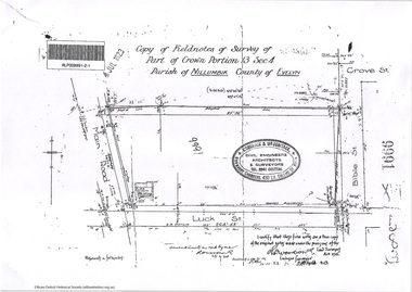
Portion of land bounded by: Main Road, Luck Street, Bible Street, Arthur Street Application 37314 W. P. Steane, M.C.E. Civil Engineer and Surveyor, 18 May 1908application 37314, arthur street, bible street, eltham, luck street, main road, map, survey plan -
 Eltham District Historical Society Inc
Document - Photocopy, Survey Fleld Notes of Part of Crown Portion 13, Section 4 at Eltham, Parish of Nillumbik, County of Evelyn, 31 May 1907
Portion of land east of Main Road and north of Luck Street bounded by Bible Street Application 36708 K. Arndt, Licensed Surveyor, 31 May 1907application 36708, bible street, eltham, luck street, main road, map, survey plan -
 Eltham District Historical Society Inc
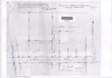
Document - Photocopy, Survey Fleld Notes of Part of Crown Portion 13, Section 4 at Eltham, Parish of Nillumbik, County of Evelyn, November 1909
Portion of land bounded by Main Road, Arthur Street, Bible Street, Henry Street Application 36708 K. Arndt, Licensed Surveyor, November 1909application 5289, arthur street, bible street, eltham, henry street, main road, map, survey plan -
 Eltham District Historical Society Inc
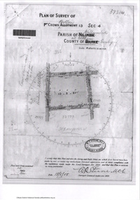
Document - Photocopy, Survey Fleld Notes of Part of Crown Portion 12, Section 4 at Eltham, Parish of Nillumbik, County of Evelyn, 12 October 1910
Portion of land bounded by: Main Road, John Street, Bible Street, Pitt Street Application 38858 K. Arndt, Licensed Surveyor, 12 August 1910application 38858, bible street, eltham, john street, main road, map, pitt street, survey plan -
 Eltham District Historical Society Inc
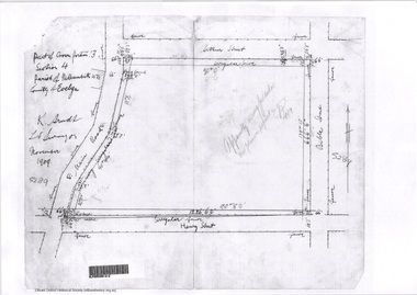
Document - Photocopy, Survey Fleld Notes of Part of Crown Portion 12, Section 4 at Eltham, Parish of Nillumbik, County of Evelyn, 20 May 1911
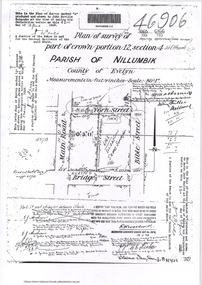
Portion of land bounded by: Main Road, York Street, Bible Street, Bridge Street Application 38629 Frederick Dudley Smith, M.C.E. Licensed Surveyor, 20 May 1911application 38629, bible street, bridge street, eltham, main road, map, survey plan, york street -
 Eltham District Historical Society Inc
Document - Photocopy, Survey Fleld Notes of Part of Crown Portion 13, Section 4 at Eltham, Parish of Nillumbik, County of Evelyn, 7 January 1924
Portion of land north of Luck Street bounded by: Main Road, Bible Street Application 9991 R. Woodstock, Land Surveyor, 7 January 1924application 9991, bible street, eltham, luck street, main road, map, survey plan -
 Eltham District Historical Society Inc
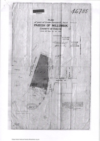
Document - Photocopy, Survey Fleld Notes of Part of Crown Portion 13, Section 4 at Eltham, Parish of Nillumbik, County of Evelyn, 7 May 1925
Portion of land bounded by: Main Road, Eltham Railway Station Application 46785 J.T. Robinson, Surveyor, 7 May 1925application 46785, arthur street, bible street, eltham, eltham railway station, luck street, main road, map, survey plan -
 Eltham District Historical Society Inc
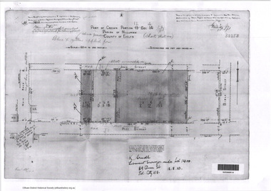
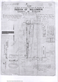
Document - Photocopy, Survey Fleld Notes of Part of Crown Portion 12, Section 4 at Eltham, Parish of Nillumbik, County of Evelyn, 30 September 1925
Portion of land bounded by: Main Road, Franklin Street, Bible Street, Brougham Street Application 46839 R. Woodcock, Licensed Surveyor, 30 September 1925application 46839, bible street, brougham street, eltham, franklin street, main road, map, survey plan -
 Eltham District Historical Society Inc
Survey Fleld Notes of Part of Crown Portion 13, Section 4 at Eltham, Parish of Nillumbik, County of Evelyn, 17 May 1926
Portion of land bounded by: Eltham Railway Station, Main Road, Luck Street, Arthur Street Application 4182/215 J.T. Robinson, Licensed Surveyor, 17 May 1926application 4182/215, arthur street, eltham, eltham railway station, luck street, main road, map, survey plan -
 Eltham District Historical Society Inc
Document - Photocopy, Survey Fleld Notes of Part of Crown Portion 12, Section 4 at Eltham, Parish of Nillumbik, County of Evelyn, 18 March 1926
Portion of land bounded by: Main Road, York Street, Bible Street, Bridge Street Application 46906 R.H. Woodcock, Licensed Surveyor, 18 March 1926application 46906, bible street, bridge street, eltham, main road, map, survey plan, york street -
 Eltham District Historical Society Inc
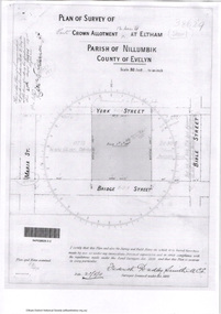
Document - Photocopy, Survey Fleld Notes of Part of Crown Portions 12 & 13, Section 4 at Eltham, Parish of Nillumbik, County of Evelyn, 6 May 1929
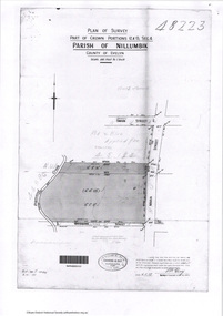
Portion of land bounded by: Main Road, York Street, Diamond Creek, Swan Street Application 48223 P.N. Guy, Licensed Surveyor, 6 May 1929application 48223, diamond creek (creek), eltham, main road, map, survey plan, swan street, york street -
 Eltham District Historical Society Inc
Document - Folder, Panton, Joseph Anderson
Joseph Anderson Panton (1831-1913) came from Scotland to Australia in 1851. In Bendigo, he was appointed assistant gold commissioner 1852 and senior commissioner 1854. Over the years, he served as magistrate at Jamieson-Wood's Point, Anderson's Creek, Heidelberg, Geelong and Melbourne. He owned land on the Yarra River and Panton Hill is named for him. Contents Map: J A Panton's landholding with surrounding landholders. Printout and photocopy: Panton, Joseph Anderson, Australian Dictionary of Biography entry. Notes: Joseph Anderson Panton, brief biographical notes. Research Enquiry Form: Vivienne Worthington, seeking sources of information regarding Joseph Anderson Panton, 14 June 2017. Email and associated documents: Michael Kennedy seeking assistance of Eltham Gateway Action Group regarding proposed felling of manna gum tree near bridge across Diamond Creek, on land once held by Joseph Anderson Panton. Newspaper article: "Historic painting might be lost to Victoria," The Age, 22 October 1985. Painting by Joseph Anderson Panton of Captain William Lonsdale's house, Victoria's first Government House, to be in forthcoming auction. Newspaper clippings, A4 photocopies, etcjoseph anderson panton, william b burnley, w walsh, r hall, r a davidson, j orford, b speers, a speers, william bell, t baillie, d mcloughlin, t prior, g e hodgkins, n rodda, w r belcher, g d boursiquot, j p imley, t b darling, h g jones, t sweny, r lane, w gordon, a e morris, d w thring, j carfrae, thomas sweeney, michael kennedy, vivienne worthington, william crozier, j frank, p carrucan, panton hill -
 Eltham District Historical Society Inc
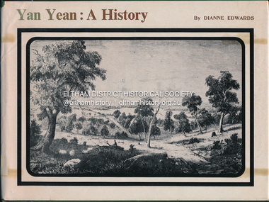
Book, Dianne H. Edwards, Yan Yean: A History, 1978
Wurunjerrai - Baluk tribe in the area; place names.Ex Eltham College Library; various library markings wurundjeri woi wurrung, yan yean -
Glen Eira Historical Society
Document - Goldstein, Vida
One item on electoral division of Goldstein. Profile details of electoral division, updated 22/02/2012 plus map showing boundaries of Electoral Division of Goldstein gazette 24/12/2012.electoral boundaries, ‘goldstein’, vida goldstein, suffragist, feminist movement, maps -
 Glen Eira Historical Society
Article - Howitt Family
Photocopied extract on ‘The Howitt Family of Barragunda’ from ‘Early Pioneer Families of Victoria and Riverina’ includes black photos of family. Handwritten family tree – source unknown. Two handwritten foolscap sheets with extracts from Caulfield Rate Books, 1857-1891 where Howitt is listed as owner of properties, records tenants, addresses, size of property and value. Typewritten notes on the biography of Dr. Godfrey Howitt, outlines qualifications, endowments, interest, membership, no map included – it says Foot Survey Map. Howitt, Alfred William, typed and handwritten notes, references to house. Notes on publications written by Howitts, and the roles they undertook.bakewell, millman william, howitt godfrey dr., howitt john henry, howitt richard, howitt phoebe, mrs. nee godfrey bakwell, howitt william, howitt edward, howitt charles ernest, howitt edith mary, howitt alfred william, burke and wills expedition, king john, ‘rosemont’ kooyong rd, melbourne university, pioneer, botanist, naturalist, squatters, doctors, crotonhurst rd, caulfield, kooyong rd west, balaclava rd west, eyre rd, hume rd, howitt thomas, tantum phoebe, boothby benjamin judge, botham mary, millman william, mcwilliams robert, blake arthur palmer, grice james, spretchley edward, mcnaughton goerge, campbell john a., serle w.h., howitt mary, mickle royal society of victoria, st. mary’s church of england caulfield, stables, slab huts, police magistrate, authors -
Glen Eira Historical Society
Ephemera - Riddell Family
2 photocopied maps, one dated 1884 of the Gardenvale Estate and then named Riddell Estate, taken from the State Library of Victoria website. Research note by Claire Barton dated 16/04/2013 concerning Carre Street subdivision. Article from ‘Glen Eira Leader’ dated 13/11/2002 with advertisement for sale of an apartment in Renown Apartments.gardenvale estate, glen huntly road, elsternwick, \fraser and co., mcmillan street, brighton road, orrong road, rowan street, archibald street, hamilton street, downshire road, shoobra road, riddell mrs, elsternwick railway station, stanley street, gisborne street, carre street, muntz and muntz, ‘cave carre’, brighton railway, subdivisions, housenames -
Glen Eira Historical Society
Map - Orienteering
This file contains one item. A map/plan of the Bentleigh East Running Roulette for the Monday series on 21/03/2011.bayside kangaroos orienteering, bentleigh east, sedunary vic, leicester paul, sheahan jenny, clubs, sheahan john, tamblyn greg, centre road bentleigh, tucker road bentleigh, south road moorabbin, associations, nepean highway, bentleigh rsl club, orienteering, sports, recreations -
Glen Eira Historical Society
Plan - Chinese Community in Glen Eira
Three pages on Chinese in Glen Eira. One hand drawn map of residents living in surrounds of Murton Hall, Chinese Church from SANDS AND MCDOUGALLS 1914 edition by Claire Barton. Printed page from FILE 1234 on Thomson Memorial Church. Hand written Chinese gardeners and related associations from SANDS AND MCDOUGALLS. Page from PROV Book 2013 with a Victorian Garden License.ruby street, reeves william, murton hall, chinese church, malva street, beattie rev. j., ocean street, gould mrs. s., belmont, house names, munn harry, maud street, ormond hall, taylor herbert, raymond rev. h., north road -
Glen Eira Historical Society
Plan - Pascoe Avenue, 26, Bentleigh
Document detailing two valuations by National Trustees Co of the property at 26 Pascoe Ave, Bentleigh, the first valuation is dated 14/07/1954 and the second dated 19/07/1957. Included are handdrawn plans, handwritten notes and typed valuations listing values of architectural features, and correspondence from National Trustees Co. for both 1954 and 1957. The 1954 documents were clearly used in the 1957 valuation.pascoe ave, land subdivisions, land values, bentleigh, pergolas, architectural features, parish of moorabbin, plans, architectural styles, county of bourke, maps, brick houses, national trustees co, illustrations, dendy’s crown special survey -
Glen Eira Historical Society
Plan - Ristori
Real Estate leaflet for the subdivision sale of the Ristori Estate & Residence on 31/05/1919 by Yeo, Crosthwaite & Co. A map of the 24 subdivisions available plus a locality plan are included along with details of separate sale on 04/06/1919 of the weatherboard buildings, rooms, stables & glass house.house names, 'ristori', land sales, sewerage, glen eira road, brick houses, land subdivision, orrong road, glasshouses, yeo crosthwaite & co melbourne, ripponlea, stables, ristori estate, auctions, drainage, liscard street, st. georges road, balaclava road, glen huntly road, glenhuntly road, elsternwick station, hotham street, weatherboard buildings, elsternwick -
 Glen Eira Historical Society
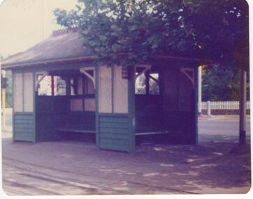
Article - Tram Shelter, Dandenong Road
National Trust of Australia, Victoria, report giving details of tram shelters on the tramways routes of Melbourne; history of cable car system and reasons for tramways amalgamations, includes architectural plan, map and photocopies of two photographs before restoration 1994. Includes bibliography. Two coloured photographs of tram shelter Dandenong Road opposite Hawthorn Road taken in 1978. Detailed history from the Trust News 2000 on history of Melbourne Tram Shelters, various architectural design features, where erected and who design by.dandenong road, hawthorn road, north caulfield, glen eira, flannagan l.s., prahran and malvern tramways trust, street furniture, tram shelters, edwardian style, architectural features, glenhuntly road, caulfield, orrong road, balaclava road, watson stephen, storey rohan, ward andrew -
Glen Eira Historical Society
Map - Brighton Cemetery, North Road, Caulfield South
Photocopy of a typed letter from the National Trust (Victoria), dated 23/10/1997, to Brighton Cemetery Trust, notifying of the classification o the cemetery in the National Trust Register. An undated photocopy of a map and plan of Brighton Cemetery.brighton cemetery, north road, caulfield south, burke chris, brighton cemetery trust, sheffield road, hawthorn road, cemeteries, grave yards -
Glen Eira Historical Society
Document - Helenslea, Shelford CEGGS
Three copies of a photocopied fold out brochure for the auction of Helenslea mansion and stables on 25/03/1916 in association with the sale of the adjoining allotments of the Helenslea Estate. The brochure includes a map of the Helenslea Estate, a photograph of the view from Helenslea Mansion, an illustration of the exterior of the Mansion and a detailed floor plan of the Mansion and stables.helenslea mansion, helenslea estate plan, glen eira road, hood crescent, merton street, stables, hawthorn road, orrong road, morrice street, helenslea road, st kilda east, auctions, st mary’s church, caulfield north, land subdivision, land brochures, residential development -
Glen Eira Historical Society
Document - Helenslea, Shelford CEGGS
Three copies of a photocopied fold out brochure relating to the auction of 48 lots in the Helenslea Estate on 25/03/1916. The brochure references St Mary’s Church, shops on Glen Eira Road, Caulfield Grammar School, and existing homes in the vicinity and includes photographs of these localities. Reference is also made to available public transport and trees on the Estate. The brochure also includes an illustrated bird’s eye map of the Estate.helenslea estate, glen eira road, st kilda east, mansions, orrong road, balaclava road, caulfield grammar school, fosberry avenue, st mary’s church, land subdivision, land brochures, residential development, auctions, caulfield north -
Glen Eira Historical Society
Document - Maysbury, Maysbury Avenue, 1, Elsterwick
Two photocopies of a map showing the mansion Maysbury, before the construction of Maysbury Avenuemay street, st.georges road, staniland grove, sanham street, king street, beavis street, grafton street -
Glen Eira Historical Society
Document - Nithsdale
Photocopied copy of flyer for forthcoming subdivision of Caulfield Heights Estate on 27/10/1888. Includes locality plan and subdivisions. Photocopied copy of flyer for forthcoming sale of properties and mansion, Nithsdale on 18/09/1889, includes map of area.carriages and coaches, caulfield heights estate, caulfield north, maxwell grove, kambrook road, neerim road, blake street, bambra road, racecourse road, auctioneers, station street, glen eira road, paynes j., mansion, beauchamp brothers