Showing 753 items
matching housing - victoria
-
 Whitehorse Historical Society Inc.
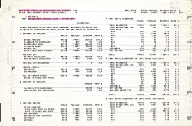
Document, 1981 Census of population and housing, 1981
Copy of Australian Bureau of Statistics census of population and housing, 1981, Legislative Council Seat of Nunawading.Copy of Australian Bureau of Statistics census of population and housing, 1981, Legislative Council Seat of Nunawading.non-fictionCopy of Australian Bureau of Statistics census of population and housing, 1981, Legislative Council Seat of Nunawading.australia. census, 1981, victoria. parliament. nunawading seat, population -
 Whitehorse Historical Society Inc.
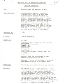
Document, Landscape Submission, c 1976
A landscape submission written for the National Trust of Australia (Victoria) for Blackburn Lake and the Bell Bird Streets.A landscape submission written for the National Trust of Australia (Victoria) for Blackburn Lake and the Bell Bird Streets. Definitions given of boundaries of the Lake area, ownership, housing and gardens. Photographs and map.A landscape submission written for the National Trust of Australia (Victoria) for Blackburn Lake and the Bell Bird Streets.blackburn lake sanctuary, waratah crescent, blackburn, jeffery street, hill street, boongarry avenue, linum street, laurel grove, acacia avenue, city of nunawading, melbourne and metropolitan board of works, furness park, camberwell grammar school -
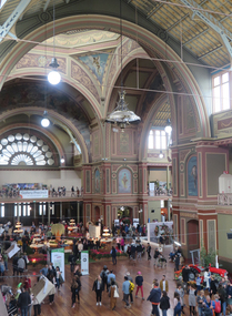
 Ballarat Heritage Services
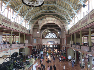
Photograph - Photograph -Colour, Clare Gervasoni, Interior of the Melbourne Exhibition Building, 2019, 31/03/2019
A competition was announced to design a suitable building for the proposed Melbourne International Exhibition in December 1877. Eighteen entries were received. The winner of 300 pounds was Joseph Reed of the architectual firm Reed and Barnes. The foundation stone was laid by Governor Sir George Bowen on 19 February 1879. Prominent Melbounre builder David Mitchell, father of Dame Nellie Melba, won the tender to construct the main building. Exhibitors were able to move in by May 1880. On 01 October 1880 the Melbourne International Exhibition opened, when over 6000 people entered the main hall to see the Governor, the Marquess of Normanby open the show. Thirty three nations participated and ofver 32,000 exhibits were displayed. At the close of the exhibition on 30 April 1881 over 1.3 million people had visited the exhibition. In 1881 Victoria's population was just over 250,000. The management of the Exhibition Building and eight hectares of the Carlton Gardens was handed to the Exhibition Trustees by the Melbourne International Exhibition Commissioners on 01 OCtober 1881. The Trustees maintained the building for 'future public exhibitions and ... general public instruction and recreation' until 1996 when management of the building was transferred to Museum Victoria. In 1901 when the Australian colonies federated there was no capital and no federal parliament building. The Federal Parliament moved into the Victorian State Parliament building, and the State Parliament moved into the Western Annexe of the Exhibition Building for 26 years. After World War One, on 04 February 1919, the exhibition Building was turned into a hospital to treat Melbournians struck down with the Spanis 'Flu'. Initially housing 500 beds, the hospital grew to accomodate 2000 patients. Femals were located between the concert platform in the western nave and the done; male patients occupied the spaces beyond. The basement was used a a morgue. With the departure of the State Parliament in 1927 the western annexe became home to the Country Roads Board. In 1932 it was joined by the MOtor Registration Branch, and the Transport Regulation Board in 1934. They co-existedin cramped offices until the 1960s. In 1949 the oval at the rear of the ExhibitionBuilding was leased to the Commonealth Government for the establishment of the Migrant Reception Centre. When it closed in 1961-62, the centre comrised 29 bungalows over 1.4 hectare. The centre provided temporary accomodation for thousands of new arrivals from Britain. On 01 July 2004 the Royal Exhibition Building and Carlton Gardens were inscribed on the World Heritage List. It is the only 19th century Great Hall to survive largely intact, still in its original landscape setting, and still used as a palace of industry. The Melbourne International Flower and Garden Show is a flower show held annually since 1995 in early April each year, in Melbourne, Australia. It is located in the World Heritage Site of Carlton Gardens and the Royal Exhibition Building.[1] It is the largest horticultural event in the southern hemisphere, attracting over 100,000 visitors. It is rated among the top five flower and garden shows in the world. (Wikipedia)Colour photograph of the interior of the Melbourne Exhibition Buildings during the 2019 Melbourne Flower and Garden Show.melbourne international flower and garden show, carlton gardens, melbourne exhibition building, royal exhibition buildings -
 Ballarat Heritage Services
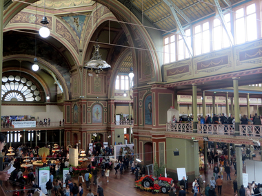
Photograph -Colour, Clare Gervasoni, Interior of the Melbourne Exhibition Building, 2019, 31/03/2019
A competition was announced to design a suitable building for the proposed Melbourne International Exhibition in December 1877. Eighteen entries were received. The winner of 300 pounds was Joseph Reed of the architectual firm Reed and Barnes. The foundation stone was laid by Governor Sir George Bowen on 19 February 1879. Prominent Melbounre builder David Mitchell, father of Dame Nellie Melba, won the tender to construct the main building. Exhibitors were able to move in by May 1880. On 01 October 1880 the Melbourne International Exhibition opened, when over 6000 people entered the main hall to see the Governor, the Marquess of Normanby open the show. Thirty three nations participated and ofver 32,000 exhibits were displayed. At the close of the exhibition on 30 April 1881 over 1.3 million people had visited the exhibition. In 1881 Victoria's population was just over 250,000. The management of the Exhibition Building and eight hectares of the Carlton Gardens was handed to the Exhibition Trustees by the Melbourne International Exhibition Commissioners on 01 OCtober 1881. The Trustees maintained the building for 'future public exhibitions and ... general public instruction and recreation' until 1996 when management of the building was transferred to Museum Victoria. In 1901 when the Australian colonies federated there was no capital and no federal parliament building. The Federal Parliament moved into the Victorian State Parliament building, and the State Parliament moved into the Western Annexe of the Exhibition Building for 26 years. After World War One, on 04 February 1919, the exhibition Building was turned into a hospital to treat Melbournians struck down with the Spanis 'Flu'. Initially housing 500 beds, the hospital grew to accomodate 2000 patients. Femals were located between the concert platform in the western nave and the done; male patients occupied the spaces beyond. The basement was used a a morgue. With the departure of the State Parliament in 1927 the western annexe became home to the Country Roads Board. In 1932 it was joined by the MOtor Registration Branch, and the Transport Regulation Board in 1934. They co-existedin cramped offices until the 1960s. In 1949 the oval at the rear of the ExhibitionBuilding was leased to the Commonealth Government for the establishment of the Migrant Reception Centre. When it closed in 1961-62, the centre comrised 29 bungalows over 1.4 hectare. The centre provided temporary accomodation for thousands of new arrivals from Britain. On 01 July 2004 the Royal Exhibition Building and Carlton Gardens were inscribed on the World Heritage List. It is the only 19th century Great Hall to survive largely intact, still in its original landscape setting, and still used as a palace of industry. The Melbourne International Flower and Garden Show is a flower show held annually since 1995 in early April each year, in Melbourne, Australia. It is located in the World Heritage Site of Carlton Gardens and the Royal Exhibition Building.[1] It is the largest horticultural event in the southern hemisphere, attracting over 100,000 visitors. It is rated among the top five flower and garden shows in the world. (Wikipedia)Colour photograph of the interior of the Melbourne Exhibition Buildings during the 2019 Melbourne Flower and Garden Show. Four mottoes are painted under teh windows of the dome: Dei Grecia (By the grace of God), Carpe diem (Make the most of the day), Aude sapere (Dare to be wise) and Benigno numine (With benighn power)melbourne international flower and garden show, carlton gardens, melbourne exhibition building, royal exhibition buildings -
 Ballarat Heritage Services
Photograph - Photograph -Colour, Clare Gervasoni, Interior of the Melbourne Exhibition Building, 2019, 31/03/2019
A competition was announced to design a suitable building for the proposed Melbourne International Exhibition in December 1877. Eighteen entries were received. The winner of 300 pounds was Joseph Reed of the architectual firm Reed and Barnes. The foundation stone was laid by Governor Sir George Bowen on 19 February 1879. Prominent Melbounre builder David Mitchell, father of Dame Nellie Melba, won the tender to construct the main building. Exhibitors were able to move in by May 1880. On 01 October 1880 the Melbourne International Exhibition opened, when over 6000 people entered the main hall to see the Governor, the Marquess of Normanby open the show. Thirty three nations participated and ofver 32,000 exhibits were displayed. At the close of the exhibition on 30 April 1881 over 1.3 million people had visited the exhibition. In 1881 Victoria's population was just over 250,000. The management of the Exhibition Building and eight hectares of the Carlton Gardens was handed to the Exhibition Trustees by the Melbourne International Exhibition Commissioners on 01 OCtober 1881. The Trustees maintained the building for 'future public exhibitions and ... general public instruction and recreation' until 1996 when management of the building was transferred to Museum Victoria. In 1901 when the Australian colonies federated there was no capital and no federal parliament building. The Federal Parliament moved into the Victorian State Parliament building, and the State Parliament moved into the Western Annexe of the Exhibition Building for 26 years. After World War One, on 04 February 1919, the exhibition Building was turned into a hospital to treat Melbournians struck down with the Spanis 'Flu'. Initially housing 500 beds, the hospital grew to accomodate 2000 patients. Femals were located between the concert platform in the western nave and the done; male patients occupied the spaces beyond. The basement was used a a morgue. With the departure of the State Parliament in 1927 the western annexe became home to the Country Roads Board. In 1932 it was joined by the MOtor Registration Branch, and the Transport Regulation Board in 1934. They co-existedin cramped offices until the 1960s. In 1949 the oval at the rear of the ExhibitionBuilding was leased to the Commonealth Government for the establishment of the Migrant Reception Centre. When it closed in 1961-62, the centre comrised 29 bungalows over 1.4 hectare. The centre provided temporary accomodation for thousands of new arrivals from Britain. On 01 July 2004 the Royal Exhibition Building and Carlton Gardens were inscribed on the World Heritage List. It is the only 19th century Great Hall to survive largely intact, still in its original landscape setting, and still used as a palace of industry. The Melbourne International Flower and Garden Show is a flower show held annually since 1995 in early April each year, in Melbourne, Australia. It is located in the World Heritage Site of Carlton Gardens and the Royal Exhibition Building.[1] It is the largest horticultural event in the southern hemisphere, attracting over 100,000 visitors. It is rated among the top five flower and garden shows in the world. (Wikipedia)Colour photograph of the interior of the Melbourne Exhibition Buildings during the 2019 Melbourne Flower and Garden Show. Four mottoes are painted under teh windows of the dome: Dei Grecia (By the grace of God), Carpe diem (Make the most of the day), Aude sapere (Dare to be wise) and Benigno numine (With benighn power)melbourne international flower and garden show, carlton gardens, melbourne exhibition building, royal exhibition buildings -
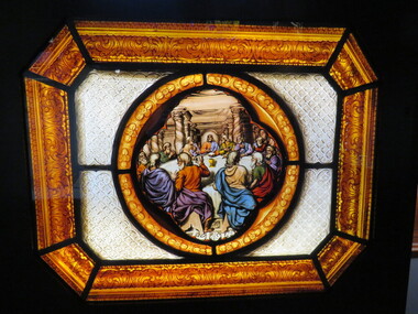 Ballarat Heritage Services
Photograph - Digital photograph, Victoria and Albert Museum, London, 2016, 09/2016
The V&A is the world’s leading museum of art and design, housing a permanent collection of over 2.3 million objects that span over 5,000 years of human creativity. The Museum holds many of the UK's national collections and houses some of the greatest resources for the study of architecture, furniture, fashion, textiles, photography, sculpture, painting, jewellery, glass, ceramics, book arts, Asian art and design, theatre and performance. https://www.vam.ac.uk/info/about-usDigital photographs of a stained glass window at the Victoria And Albert Museum, Londonvictoria and albert museum, window, interior, stained glass window -
 Ballarat Heritage Services
Photograph - Digital photograph, Lisa Gervasoni, Housing in Cotham Ward, Kew, 2017
Housing units in Cotham Road, Kewkew, housing, streetscape, archiecture -
 Ballarat Heritage Services
Photograph - Digital photograph, Lisa Gervasoni, Housing in Cotham Ward, Kew, 2017
... house in Kew, Victoria Housing in Cotham Ward, Kew Photograph ...Double Storey brick house in Kew, Victoriakew, housing, streetscape -
 Ballarat Heritage Services
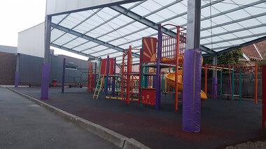
Photograph - Digital photograph, Lisa Gervasoni, Playground at Sacred Heart Catholic School, Kew, 2017
Colour photograph of a playground at Playground at Sacred Heart Catholic School, Kew kew, housing, streetscape, sacred heart kew, playground -
 Ballarat Heritage Services
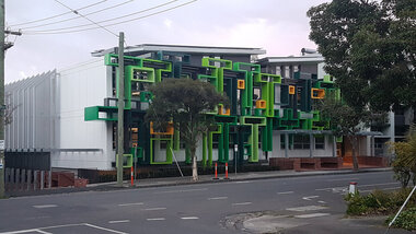
Photograph - Digital photograph, Lisa Gervasoni, Housing in Cotham Ward, Kew, Victoria, 2017
Double storey building in Kew, a suburb of Melbournekew, housing, streetscape, architecture -
 Lakes Entrance Historical Society
Photograph, Jack Palmer, 1950 c
Also five other black and white photographs taken at same time of housing at village 6 x 8.5 cmBlack and white photograph of view of village established for workers at Snowy Mountains Scheme Australian Alps Victoriacouncil, government -
 RMIT Design Archives
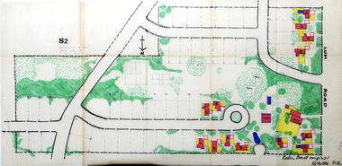
Work on paper - Architectural drawings, Colour plan of Lum road estate, 1970-1986
This plan of Lum Road Estate includes layout of roads, gardens, building and carparks. From 1970 until August 1971 Robin Boyd and his practice Romberg & Boyd Architects worked on designs for housing on the Lum Road Estate, Wheelers Hill. Berenice Harris, Linley Vellacott and Karl Fender drew many of the sketch plans for the project homes, while Robin Boyd drew the perspectives. This colour plan of the estate was drawn by Robin Boyd, but not signed. Frederick Romberg later annotated the drawing with details of its authorship. Colour plan of Lum road estate. Includes layout of roads, gardens, buildings and flora.Inscribed lower right on recto in black ink, 'Robin Boyd original / 12/6/86 F.R' ; Inscriber upper left on recto, grey pencil, '3400'.architecture, design, rmit design archives, domestic architecture -
 RMIT Design Archives
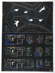
Architectural drawings, Plans and details for the Group Housing Project, Ivanhoe
Includes site plan; floor plans and details of utilities, interior and fittings.architecture, domestic architecture -
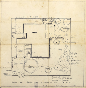 RMIT Design Archives
Diazotypes, Sketch Plan: Garden Layout - 13 Edward St. Kew
John and Phyllis Murphy designed this house and garden in Kew for Sir Frank and Lady Macfarlane Burnet in 1959, the year before Burnet and Peter Medaware received the Nobel Prize for discovering acquired immunological tolerance. For the most highly honoured scientist to have worked in Australia, Burnet's house is modest - single storey with two bedrooms. Typical of post-war suburban housing thought, the garden is a generous, and the planting a mix of existing shrubs and trees, old favourites such as camelias, hydrangeas, lilacs, and a unusually 'a thick copse of native trees'. John Murphy (1920-2004) and Phyllis Murphy (nee Slater) (1924-) are alumni of RMIT. John commenced his architectural studies at Swinburne Technical College prior to WW2, and subsequently studied at Melbourne Technical College (now RMIT University) from 1944 to 1946. Phyllis studied architecture at Melbourne Technical College from 1942, before transferring to Melbourne University's Architectural Atelier in 1944 They both completed their Bachelor of Architecture in 1949, with Phyllis topping the fourth year, and John coming in second. They established their architectural practice in 1950. One early project was their design with Kevin Borland and Peter McIntyre for the Olympic Swimming Pool (1956). Ann Carew 2018dye, paper, garden design, kew -
 Department of Health and Human Services
Photograph, Berry Street Kindergarten
In 1877 the Victorian Infant Asylum was founded in Kew. In 1881, the asylum relocated to Berry Street in East Melbourne. By 1908, it was called the Foundling Hospital and Infants Home. It was non-denominational and controlled by a committee of management. By 1956, Berry Street consisted of a Mothercraft Training Centre and two main residential units: Berry Street for infants aged zero to 18 months, and Vale Street for toddlers aged zero to two years old. In August 1956, Berry Street was declared an approved category 2 Children's Home. In 1960, Vale Street was converted to an adult nursing home. In 1964, the name was changed to Berry Street Babies Home and Hospital. Berry Street was also an approved adoption agency. By 1968, Berry Street comprised the Training School for Mothercraft Nurses, the adoption agency, an infant life-protection house, a long-stay home for children to three years of age (the toddlers’ wing) and a small house for unmarried mothers. The home's infant life-protection work was seen as a critical agency function, particularly where family illness was putting pressure on mothers and Berry Street was able to provide respite and support. By the late 1960s, 30–40 adoptions annually were being arranged from Berry Street. By 1974 the home's orientation had shifted. Four family group homes had been established (two in Burwood, one in Ashburton and one in St Kilda), the mothercraft training function had been phased out, the toddlers wing converted to day care, and the main building (containing the nursery, administration, kitchen, dining room and single mothers accommodation) was demolished in favour of four home units, which housed 24 children, supervised by cottage parents. Berry Street provided short term, emergency and residential care for 'protection of infant' cases and state wards. Two flats were also established for short-term family accommodation. The nurses’ home was converted to house the home’s administration function and a social work service. The social work service coordinated family aid and family counselling services, and a neighbourhood house. In 1975 Berry Street also provided short-term care for 42 Vietnamese children brought to Australia in the official government-sponsored airlift. In 1976 Berry Street made application to change its category 2 Children's Home classification to category 1, as it was now catering for a wider range of children. It had ceased to be a babies’ home and hospital, and had started providing child and family care, including residential care. In 1977 Berry Street to established a family group home in Richmond to house children affected by the closure of St Cuthbert's Children's Home in Colac. Berry Street changed its name to Berry Street Child and Family Care in 1977. In 1978, the range of services provided by Berry Street Child and Family Care consisted of a social work counselling service, a financial aide, a family aide program using volunteers, two temporary accommodation units each housing eight children, an information and referral service, a neighbourhood house in Richmond, a day care centre for 36 children, and four family group homes. In 1980–81 the family group homes in Burwood were sold and the resources moved to the Richmond area. In 1994, Sutherland Youth and Family Services Inc. amalgamated into Berry Street Inc. During the 1990s, Berry Street combined with the Sutherland Community Resource Centre in Watsonia in Melbourne’s northern region. The agency operates today as Berry Street Victoria and has service centres across metropolitan and country Victoria. https://www.findingrecords.dhhs.vic.gov.au/CollectionResultsPage/BerryStreet -
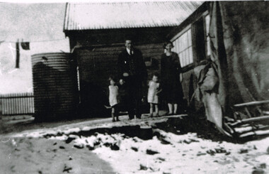 Otway Districts Historical Society
Photograph, Laurie McCabe, wife and children at their railway house, Beech Forest, Mid 1920s
In order to accommodate its key Otways staff of train crews, station masters and gangers the VR provided departmental housing. Laurie McCabe, a former porter at Wyelangta, a player in the local football team, and married to one of the potato-growing families, was the Station Master becoming the travelling station master and guard in 1930. He was based in Beech Forest and housed departmentally with his wife, Victoria Elizabeth (nee Tann) and their two children.Laurie McCabe, Travelling Station Master and goods Guard, his wife, Victoria, and their two children outside their railway house at Beech Forest. B/W.beech forest; railway; departmental housing; -
Queenscliffe Maritime Museum
Binnacle from Victoria Tower, see description
In memory of the owner's husband Chief Petty Officer(GNR) Frank Hillier RANHousing for a ship's compass with a window at the back to light the face of the compass during daylight and a small compartment on the right hand side with a hinged door for inserting a candle for night viewing (mounted on a wooden base)Model p 6: Magnetic Liquid Compass No 2767: Date 12-1956 WT 5 kgs: Manu. by C8879 T2757: Nunotani Keiki Seisakusho Ltd: Amagasaki: Japan -
Bendigo Historical Society Inc.
Plan - SANDHURST BOYS CENTRE COLLECTION: SANDHURST TRAINING CENTRE ADMINISTRATION BUILDING FLOOR PLAN
... Victoria. Ministry of Housing and construction; Sandhurst... BENDIGO Institutions sandhurst boys centre Victoria. Ministry ...Photocopy of the Administration building floor plan, showing Clinic, switch room, store, sick ward with patients toilet, utility and cleaners rooms, nurses station, pantry, doctors office, waiting room, locker rooms, reception foyer, general office, offices for chief training officer and secretary. Location unknown 16.02.2023.bendigo, institutions, sandhurst boys centre, victoria. ministry of housing and construction; sandhurst training centre; floor plan - administration building; -
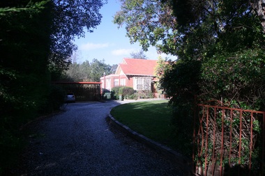
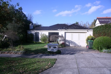
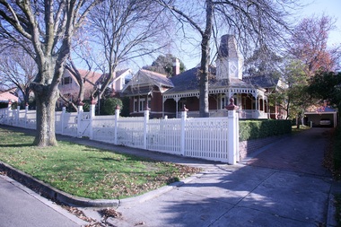
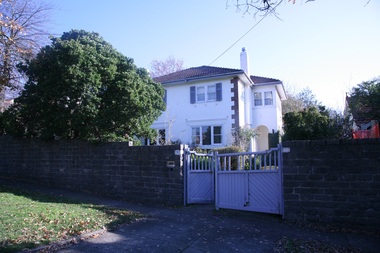
 Surrey Hills Historical Society Collection
Photograph - 5 Victoria Crescent, Mont Albert, The Street Where You Live Project
Photos documenting this address as part of a photographic series undertaken by volunteer photographers during 2013 and 2014 for The Street Where You Live Project. This was organised through the Surrey Hills Neighbourhood Centre and covered the postcode 3127 in the cities of Boroondara and Whitehorse.These photos provide a snapshot of real estate in the suburbs of Mont Albert and Surrey Hills during a period of rapid change with many properties on large blocks demolished to create higher density residential development or renewal of single dwellings. At particular risk were properties not covered by heritage overlays, in particular interwar housing and post 1950's housing. -
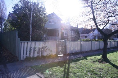
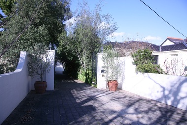
 Surrey Hills Historical Society Collection
Photograph - 6 Victoria Crescent, Mont Albert, The Street Where You Live Project
Photos documenting this address as part of a photographic series undertaken by volunteer photographers during 2013 and 2014 for The Street Where You Live Project. This was organised through the Surrey Hills Neighbourhood Centre and covered the postcode 3127 in the cities of Boroondara and Whitehorse.These photos provide a snapshot of real estate in the suburbs of Mont Albert and Surrey Hills during a period of rapid change with many properties on large blocks demolished to create higher density residential development or renewal of single dwellings. At particular risk were properties not covered by heritage overlays, in particular interwar housing and post 1950's housing. -
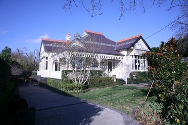
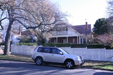
 Surrey Hills Historical Society Collection
Photograph - 7 Victoria Crescent, Mont Albert, The Street Where You Live Project
Photos documenting this address as part of a photographic series undertaken by volunteer photographers during 2013 and 2014 for The Street Where You Live Project. This was organised through the Surrey Hills Neighbourhood Centre and covered the postcode 3127 in the cities of Boroondara and Whitehorse.These photos provide a snapshot of real estate in the suburbs of Mont Albert and Surrey Hills during a period of rapid change with many properties on large blocks demolished to create higher density residential development or renewal of single dwellings. At particular risk were properties not covered by heritage overlays, in particular interwar housing and post 1950's housing. -
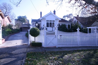
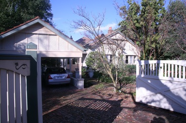
 Surrey Hills Historical Society Collection
Photograph - 8 Victoria Crescent, Mont Albert, The Street Where You Live Project
Photos documenting this address as part of a photographic series undertaken by volunteer photographers during 2013 and 2014 for The Street Where You Live Project. This was organised through the Surrey Hills Neighbourhood Centre and covered the postcode 3127 in the cities of Boroondara and Whitehorse.These photos provide a snapshot of real estate in the suburbs of Mont Albert and Surrey Hills during a period of rapid change with many properties on large blocks demolished to create higher density residential development or renewal of single dwellings. At particular risk were properties not covered by heritage overlays, in particular interwar housing and post 1950's housing. -
 Surrey Hills Historical Society Collection
Photograph - 9 Victoria Crescent, Mont Albert, The Street Where You Live Project
Photos documenting this address as part of a photographic series undertaken by volunteer photographers during 2013 and 2014 for The Street Where You Live Project. This was organised through the Surrey Hills Neighbourhood Centre and covered the postcode 3127 in the cities of Boroondara and Whitehorse.These photos provide a snapshot of real estate in the suburbs of Mont Albert and Surrey Hills during a period of rapid change with many properties on large blocks demolished to create higher density residential development or renewal of single dwellings. At particular risk were properties not covered by heritage overlays, in particular interwar housing and post 1950's housing. -
 Surrey Hills Historical Society Collection
Photograph - 10A Victoria Crescent, Mont Albert, The Street Where You Live Project
Photos documenting this address as part of a photographic series undertaken by volunteer photographers during 2013 and 2014 for The Street Where You Live Project. This was organised through the Surrey Hills Neighbourhood Centre and covered the postcode 3127 in the cities of Boroondara and Whitehorse.These photos provide a snapshot of real estate in the suburbs of Mont Albert and Surrey Hills during a period of rapid change with many properties on large blocks demolished to create higher density residential development or renewal of single dwellings. At particular risk were properties not covered by heritage overlays, in particular interwar housing and post 1950's housing. -
 Surrey Hills Historical Society Collection
Photograph - 10 Victoria Crescent, Mont Albert, The Street Where You Live Project
Photos documenting this address as part of a photographic series undertaken by volunteer photographers during 2013 and 2014 for The Street Where You Live Project. This was organised through the Surrey Hills Neighbourhood Centre and covered the postcode 3127 in the cities of Boroondara and Whitehorse.These photos provide a snapshot of real estate in the suburbs of Mont Albert and Surrey Hills during a period of rapid change with many properties on large blocks demolished to create higher density residential development or renewal of single dwellings. At particular risk were properties not covered by heritage overlays, in particular interwar housing and post 1950's housing. -
 Surrey Hills Historical Society Collection
Photograph - 11 Victoria Crescent, Mont Albert, The Street Where You Live Project
Photos documenting this address as part of a photographic series undertaken by volunteer photographers during 2013 and 2014 for The Street Where You Live Project. This was organised through the Surrey Hills Neighbourhood Centre and covered the postcode 3127 in the cities of Boroondara and Whitehorse.These photos provide a snapshot of real estate in the suburbs of Mont Albert and Surrey Hills during a period of rapid change with many properties on large blocks demolished to create higher density residential development or renewal of single dwellings. At particular risk were properties not covered by heritage overlays, in particular interwar housing and post 1950's housing. -
 Surrey Hills Historical Society Collection
Photograph - 12 Victoria Crescent, Mont Albert, The Street Where You Live Project
Photos documenting this address as part of a photographic series undertaken by volunteer photographers during 2013 and 2014 for The Street Where You Live Project. This was organised through the Surrey Hills Neighbourhood Centre and covered the postcode 3127 in the cities of Boroondara and Whitehorse.These photos provide a snapshot of real estate in the suburbs of Mont Albert and Surrey Hills during a period of rapid change with many properties on large blocks demolished to create higher density residential development or renewal of single dwellings. At particular risk were properties not covered by heritage overlays, in particular interwar housing and post 1950's housing. -
 Surrey Hills Historical Society Collection
Photograph - 13 Victoria Crescent, Mont Albert, The Street Where You Live Project
Photos documenting this address as part of a photographic series undertaken by volunteer photographers during 2013 and 2014 for The Street Where You Live Project. This was organised through the Surrey Hills Neighbourhood Centre and covered the postcode 3127 in the cities of Boroondara and Whitehorse.These photos provide a snapshot of real estate in the suburbs of Mont Albert and Surrey Hills during a period of rapid change with many properties on large blocks demolished to create higher density residential development or renewal of single dwellings. At particular risk were properties not covered by heritage overlays, in particular interwar housing and post 1950's housing. -
 Surrey Hills Historical Society Collection
Photograph - 14 Victoria Crescent, Mont Albert, The Street Where You Live Project
Photos documenting this address as part of a photographic series undertaken by volunteer photographers during 2013 and 2014 for The Street Where You Live Project. This was organised through the Surrey Hills Neighbourhood Centre and covered the postcode 3127 in the cities of Boroondara and Whitehorse.These photos provide a snapshot of real estate in the suburbs of Mont Albert and Surrey Hills during a period of rapid change with many properties on large blocks demolished to create higher density residential development or renewal of single dwellings. At particular risk were properties not covered by heritage overlays, in particular interwar housing and post 1950's housing. -
 Surrey Hills Historical Society Collection
Photograph - 15 Victoria Crescent, Mont Albert, The Street Where You Live Project
Photos documenting this address as part of a photographic series undertaken by volunteer photographers during 2013 and 2014 for The Street Where You Live Project. This was organised through the Surrey Hills Neighbourhood Centre and covered the postcode 3127 in the cities of Boroondara and Whitehorse.These photos provide a snapshot of real estate in the suburbs of Mont Albert and Surrey Hills during a period of rapid change with many properties on large blocks demolished to create higher density residential development or renewal of single dwellings. At particular risk were properties not covered by heritage overlays, in particular interwar housing and post 1950's housing.