Showing 518 items
matching map of mine
-
 Stawell Historical Society Inc
Map, Three Jacks Mine 1920, 1920
... grampians stawell mining Three Jacks Mine 1920 Three Jacks Mine 1920 ...Three Jacks Mine 1920stawell, mining -
University of Melbourne, Burnley Campus Archives
geological survey - Map, Maps of Geelong and Portarlington areas, 1963
... survey map of Portarlington, Victoria. By Dept. Of Mines ...A. Coloured geological survey map of Geelong area: showing sedimentary and igneous rock formations and contours. B. Coloured geological survey map of Portarlington, Victoria. By Dept. Of Mines, Melbourne.geological survey, geelong, portarlington -
University of Melbourne, Burnley Campus Archives
Map - Geological map, Melbourne and Suburbs, 1959
... Geological Survey of Victoria Department of Mines Geological map ...Geological map of Melbourne, 1959, modified by officers of the Geological Survey of Victoria, from earlier geological surveys. Scale 1:31.680melbourne metropolitan area, geology, geological survey of victoria, department of mines -
University of Melbourne, Burnley Campus Archives
Map (item) - Geological map, Geological map of Melbourne & suburbs. Issued by the Department of Mines, Victoria, 1937
... by the Department of Mines, Victoria, 1937 Map Geological map ... -
 Mrs Aeneas Gunn Memorial Library
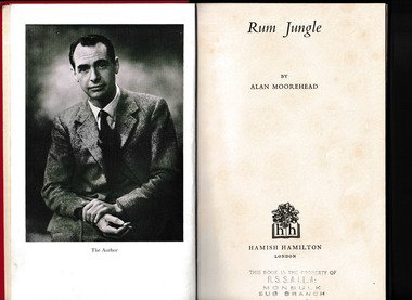
Book, Hamish Hamilton, Rum Jungle, 1953
Rum Jungle at the time was a recently discovered uranium mine. The book's principle theme is the sudden appearance of modern science in a region which has not really been civilised by white man. Anecdotal accounts of the authors travels in northern Australia, mainly NT; includes comments and stories about Aborigines; including Albert Namatjira.Ill, maps, p.154.non-fictionRum Jungle at the time was a recently discovered uranium mine. The book's principle theme is the sudden appearance of modern science in a region which has not really been civilised by white man. Anecdotal accounts of the authors travels in northern Australia, mainly NT; includes comments and stories about Aborigines; including Albert Namatjira.northern territory - description and travel, rum jungle - northern territory -
 Mrs Aeneas Gunn Memorial Library
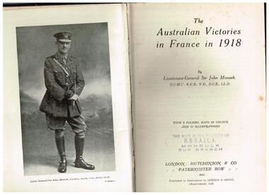
Book, John Monash, The Australian victories in France in 1918, 1920
Republished in full, this edition features a new foreword by Bruce Haigh, colour reproductions of the original maps that were hand-drawn under Monash's supervision, and new photos. It also includes a memo from General Rawlinson congratulating Monash on the performance of the Australian Corps: 'I feel that no mere words of mine can adequately express the renown that they have won for themselves and the position they have established for the Australian nation not only in France but throughout the world.'Index, ill, maps, appendices, p.351.non-fictionRepublished in full, this edition features a new foreword by Bruce Haigh, colour reproductions of the original maps that were hand-drawn under Monash's supervision, and new photos. It also includes a memo from General Rawlinson congratulating Monash on the performance of the Australian Corps: 'I feel that no mere words of mine can adequately express the renown that they have won for themselves and the position they have established for the Australian nation not only in France but throughout the world.'world war 1914-1918 - campaigns - france, world war 1914-1918 - australian involvement -
Tarnagulla History Archive
Photocopies of historic maps - Tarnagulla region, varied
... with mines near Tarnagulla (b) Parish map ?- Tarnagulla & surrounds... photocopies in clear sleeve: (a) topographic with mines near ...David Gordon Collection. Four photocopies in clear sleeve: (a) topographic with mines near Tarnagulla (b) Parish map ?- Tarnagulla & surrounds (c) Parish map ?- Tarnagulla & surrounds (d) Plan of Roads, Tarnagulla & Newbridge -
Tarnagulla History Archive
History of Tarnagulla Goldmines, 1990s
Folder containing multiple typed and handwritten notes and maps relating to the history of gold mines in Tarnagulla. Compiled by Donald Clark. Includes a series of mine assessment reports by David Bannear (1991). -
Bendigo Historical Society Inc.
Map - STRUGNELL COLLECTION: BENDIGO GOLD FIELD GEOLOGICAL SURVEY, 1936
... BHS Collection BENDIGO Gold mining geological map Dept ...BHS CollectionBendigo Goldfieds Geological Survey. Prepared in the Bendigo Office Bottom Section of original map.Dept of Mines Victoriabendigo, gold mining, geological map -
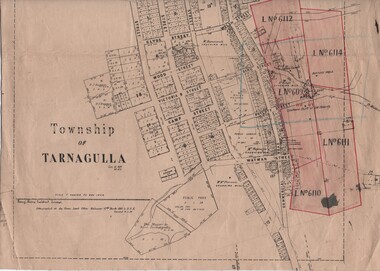 Tarnagulla History Archive
Linen-Backed Map of Tarnagulla Dated 1860 with Updates, Including Mining Leases
This is a very nice linen-backed map first published in 1860 and progressively updated, the latest being 1924 at the time of Government boring on the Poverty Reef. The map clarifies details of the mining leases as they stood in 1924, and the map also identifies previously uncertain details such as the location of the battery well, and also the location of the 1909 syndicate to the south of the Sandy Creek Co's shaft. The lightly pencilled location of the Birthday shaft is incorrect. This mine was located further to the east. -
Stawell Historical Society Inc
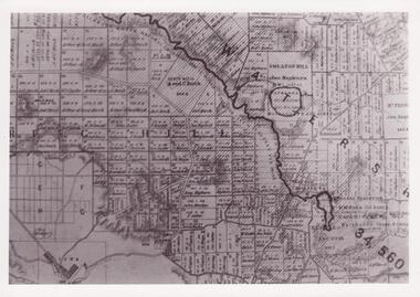
Photograph, Stawell Gold Mine, Aerial Photomap of Stawell & Mining 1997, 1997
Evaporation Dams Mining SiteLarge Laminated Aerial Photo Map showing Stawell and Mining activityMining Geology Office 1997mining -
 Federation University Historical Collection
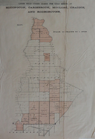
Plan, Lands held under leases for gold mining at Biddington, Carisbrook, Moolort, Craigie and Rodborough, not dated
Printed paper map with red shadingbiddington, carisbrook, moolort, craigie, rodborough, mining lease, d. fitzpatrick, m. mullins, d. fern, kong meng, p. mitchell, curtain and co, a. robertson, j. fay, chalk's extended, tullaroop creek, mining, gold mines, bucknall's estate, chalk's estate -
 Federation University Historical Collection
Map - Geological Survey, J. Phillips, Geological Survey of Victoria - Ballarat, 1857, 10/1858
Geological map of the Ballarat District featuring four colours.ballarat, geological, geology, geological plan, main road, camp, golden point, pennyweight hill, clayton hill, ballaarat cemetery, bakery hill, specimen hill, soldiers hill, nightingale lead, native youth black hill flat, white flat, mining, mines, eureka lead, old post office hill -
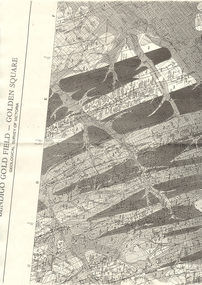 Bendigo Historical Society Inc.
Map - LONG GULLY HISTORY GROUP COLLECTION: BENDIGO GOLD FIELD - GOLDEN SQUARE GEOLOGICAL SURVEY OF VICTORIA
... and anticlines. Many of the mines are shown on the map. Gullies, hills... of the mines are shown on the map. Gullies, hills and streets are also ...BHS CollectionPart of a map of the Bendigo Gold Field - Golden Square. Geological Survey of Victoria. Shown are reefs, faults and anticlines. Many of the mines are shown on the map. Gullies, hills and streets are also shown.bendigo, history, long gully history group, the long gully history group - bendigo gold field - golden square geological survey of victoria, north bendigo state school reserve, hospital reserve, benevolent asylum reserve, empire hill, richmond hill, raes hill, south end hill, victoria hill, new chum hill, iron bark hill, redan hill, view hill, hustlers hill, camp hill -
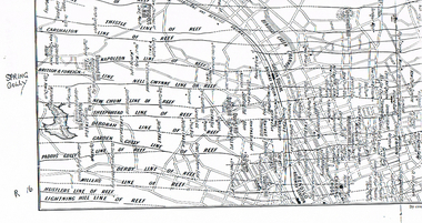 Bendigo Historical Society Inc.
Map - LONG GULLY HISTORY GROUP COLLECTION: MAP OF REEFS AND MINES
... The Long Gully History Group - Map of Reefs and Mines Spring Gully ...BHS CollectionTwo pages with lines of reef and mines from Spring Gully Reservoir to north of the Eaglehawk Railway Station. Shown on the map are the lines of reef, the Thistle, Carshalton, Napoleon, British & Foreign, Nell Gwynne, New Chum, Sheepshead, Deborah, Garden Gully, Paddy's Gully, Derby, Miller's, Hustlers, Lightning Hill, Myers Flat, Lancashire, Cook's, Maiden Gully, Johnson's and Millers. Also shown are the Golden Square, Bendigo and Eaglehawk Railway Stations as well as the hills.bendigo, history, long gully history group, the long gully history group - map of reefs and mines, spring gully reservoir, thistle, carshalton, napoleon, british & foreign, nell gwynne, new chum, sheepshead, deborah, garden gully, paddy's gully, derby, miller's, hustlers, lightning hill, myers flat, lancashire, cook's, maiden gully, johnson's, millers, golden square railway station, bendigo railway station, eaglehawk railway station -
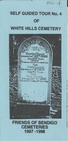 Bendigo Historical Society Inc.
Document - BENDIGO CEMETERIES COLLECTION: SELF GUIDED TOUR NO. 3 DOCUMENT
BHS CollectionBlue coloured document trifold: Self Guided Tour No. 3 of the White Hills Cemetery, Friends of Bendigo Cemeteries 1996 - 1997.Photo of John Gerber headstone on cover. Map of cemetery with numbered grave sites and descriptions of same. E.g. Ed Jackson, blinded in mine accident, cricketer H. Boyle arranged benefit football match Carlton versus Melbourne, 1st time for an entry charge to a football match. J.C. Murray, 200 pounds remittance man, died of indulgence of spirits.Friends of Bendigo Cemeteries In 1996bendigo, cemetery, white hills cemetery tour -
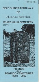 Bendigo Historical Society Inc.
Document - BENDIGO CEMETERIES COLLECTION: SELF GUIDED TOUR NO.7 DOCUMENT
BHS CollectionBlue coloured document, trifold. Self Guided Tour No. 7 of Chinese Section, White Hills Cemetery, Friends of the Bendigo Cemeteries 2-001 - 2002. Theme 'A hundred years after Federation' Map with numbered grave sites, with descriptions e.g. Louey Ah Pon, passenger involved in a fatal car accident with a bus on High St., a market gardener of Golden Square. Chung Fook Jao, committed suicide in his hut on the New Chum Mine site where he had worked the tailing for many years.Friends of the Bendigo Cemeteries 2000bendigo, cemetery, white hills cemetery tour -
 Clunes Museum
Document - MAP
... FOR THE CLUNES TOWNSHIP AND MINES. Document MAP ...PHOTO COPY. WATERSHED DAMS WEIR CREEK FOR THE COLLECTION OF WATER FOR THE CLUNES TOWNSHIP AND MINES.local history, photography, photographs, water supply -
 Bendigo Historical Society Inc.
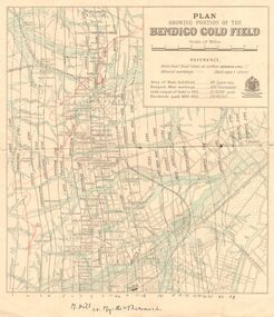
Map - DEPARTMENT OF MINES VICTORIA : PLAN SHOWING PORTION OF THE BENDIGO GOLD FIELD
... J. J. Department of Mines Victoria. Plan showing portion ...Department of Mines Victoria. Plan showing portion of the Bendigo Gold Field. On the back is written, in ink, J. J. Tyler 1937 Northern Area. (He was a teacher at Bendigo High - see donation notes). Across the bottom of the map is written ' M. Hill cr. Myrtle & Barnard' .The named reef lines have been numbered with ink across the bottom of the map. The gullies have been coloured with green pencil and a red pencil line is drawn through the western side of the map. Additional information: anticlinal axial lines at surface, alluvial workings, shaft sites, area of Main Goldfield, Deepest mine workings, Gold output of field to 1935, and Dividends paid 1870 - 1935.bendigo, gold mining, bendigo gold field. gold mining. tyler, j. j. -
 Federation University Historical Collection
Book, Final recommendations Ballarat Study Area Land Conservation Council, Victoria, 1982, 1982
Yellow soft covered report of 95 pages . The contents of the report include: Parks, reference areas, wildlife reserves, water production, harwood production, softwood production, flora Reserves and Flora and Fauna reserves, bushland reserves, historic area and reserves, rivers and streams, Roadside conservation and Highway parks, Education areas and School Plantations, Lake Reserves, geological reserves, recreation, scenic reserves, agriculture, mineral and stone production, utilities and survey, township land, Uncommitted Land, military training, other reserves and public land. Maps include: The Study area 1: 250 000 Supplementary Mapsland conservation authority, ballarat, endowment plantations, pine plantations, langi ghiran state park, mount buangor state park, enfield state park, ballarat-creswick regional park, rossbridge, black lake, flax mill swamp, dereel lagoon, lake bolac, lake wongan, langi ghiran reservoir, gong gong reservoir, pincotts reservoir, beales reservoir, wilsons reservoir, moorabool reservoir, korweinguboora, korweinguborra reservoir, learmonth bores, sago hill, illabarook reservoir, ballarat water commission, dunneworthy, mount cole, mont lonarch, ben major, waterloo, trawalla, linton, ross creek, canadian, shepherds flat, lal lal, mount doran, raglan, chute, carngham, buninyong, watsons hill, enfield, cape clear, illabrook, rokewood junction, mount warrenheip, nerrina, jubilee, golden stream, australasian deep lead mine, happy valley school, piggoreet, berringa, bulldog, ballarat common, wildlife, water, timber, flora, rivers, geology, agriculture, warrenheip, biodiversity -
 Bendigo Historical Society Inc.
Map - Geological survey of Bendigo Goldfields
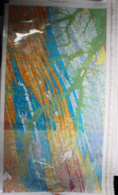
Three Geological survey maps of the Bendigo Gold Fields joined together. The three sections are Eaglehawk, Golden Square and Spring Gully. It shows geological conditions, gold reef lines and mine sights. Three sections are laminated together. The maps were produced by the Victorian Department of Manufacturing and Industry Development geological survey, bendigo gold fields -
 The Beechworth Burke Museum
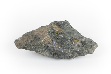
Geological specimen - Mangan Hedenbergite
This specimen was recovered from Broken Hill, NSW. It was given the name Mangan Hedenbergite in 1819 by Jöns Jakob Berzelius in honor of Mr. Anders Ludvig of Hedenberg who was the first to define hedenbergite as a mineral. Hedenbergite, belongs in the pyroxene group having a monoclinic crystal system. The mineral is extremely rarely found as a pure substance. Mangan Hedenbergite is a manganese bearing variety of Hedenbergite. Manganese is the world’s fourth most used mineral after iron, aluminium, and copper primarily because it has no satisfactory substitute in its major applications. Globally, the steel industry is the primary user of manganese metal, utilizing it as an alloy to enhance the strength and workability of steel and in the manufacture of tin cans. Manganese is a key component of certain widely used aluminium alloys and, in oxide form, dry cell batteries used in electric vehicles. These batteries are in high demand. Another potential use for manganese may as an additive to help coat and protect a car’s engine. Manganese is also used for non-metallurgical purposes such as plant fertilizers, animal feed, and colorants for bricks. This specimen is part of a larger collection of geological and mineral specimens collected from around Australia (and some parts of the world) and donated to the Burke Museum between 1868-1880. A large percentage of these specimens were collected in Victoria as part of the Geological Survey of Victoria that begun in 1852 (in response to the Gold Rush) to study and map the geology of Victoria. Collecting geological specimens was an important part of mapping and understanding the scientific makeup of the earth. Many of these specimens were sent to research and collecting organisations across Australia, including the Burke Museum, to educate and encourage further study.A hand-sized mineral specimen in shades of silver and blackmanganese, open cut mine, manganese ore processing, bell bay, tasmania, northern territory, steel industry, zinc-carbon batteries, alkaline batteries, tin cans -
 Bendigo Historical Society Inc.
Document - MARKS COLLECTION: MINING LEASE BLOCKS 1873
Plan mining lease blocks 1873, timber hanger on top two brass rings, securing tape, round timber holder on bottom, scroll. On top Schedule of Mining Lease Blocks shown on the plan of the Sandhurst Gold Field, Published May 1873' Names of mining Companies listed with identifying number and area of mine site. E.g. '447 Johnson's Reef Gold Mines 7a, 2r, 8 p (acres, roods, perches). Number linked to the mine site shown on Sandhurst Gold Field map.bendigo, mining, mining lease blocks 1873 -
Bendigo Historical Society Inc.
Map - STRUGNALL COLLECTION: BENDIGO GOLD FIELD GEOLOGICAL SURVEY, 1936
... BHS Collection BENDIGO Gold mining geological map Dept ...BHS CollectionBendigo Goldfieds Geological Survey. Prepared in the Bendigo Office Lower Section of original map. Note with map says other items donated - yet to be catalogued. TO BE FOUNDDept of Mines Victoriabendigo, gold mining, geological map -
Bendigo Historical Society Inc.
Map - STRUGNELL COLLECTION: BENDIGO GOLD FIELD GEOLOGICAL SURVEY, 1936
... BHS Collection BENDIGO Gold mining geological map Dept ...BHS CollectionBendigo Goldfieds Geological Survey. Prepared in the Bendigo Office Top Section of original map.Dept of Mines Victoriabendigo, gold mining, geological map -
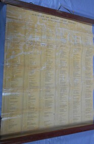
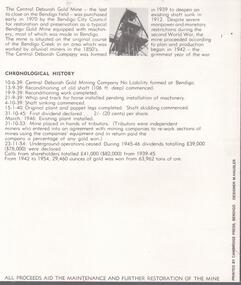 Bendigo Historical Society Inc.
Document - CENTRAL DEBORAH GOLD MINE: COMPLIMENTARY GUIDE TO THE CENTRAL DEBORAH GOLD MINE
... 'Complimentary guide to the Central Deborah Gold Mine'. Inside is a map... 'Complimentary guide to the Central Deborah Gold Mine'. Inside is a map ...BHS CollectionBlack and white bifold document, on front of document 'Complimentary guide to the Central Deborah Gold Mine'. Inside is a map and numbered features of the mine site with interpretive information.bendigo, mining, central deborah gold mine -
 Bendigo Historical Society Inc.
Document - CENTRAL DEBORAH GOLD MINE: ADVERTISING FLYER
BHS CollectionA4 advertising flyer,yellow background, black text. 'Visit the Central Deborah Gold Mine Bendigo' 'See Historic Victoria Hill'. Handrawn mud maps for each site on bottom of page.bendigo, mining, crentral deborah gold mine -
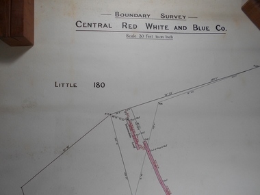 Bendigo Historical Society Inc.
Administrative record - Central Red White and Blue
... Bendigo Margaret Roberts gold Map Mine Central Red White ...Draftsman's drawing Boundary Survey Central Red White and Blue Map Forms part of the Margaret Roberts Collection of mining records.bendigo, margaret roberts, gold, map, mine, central red white and blue -
Federation University Historical Collection
Booklet - Walking Guide, Ballarat Heritage Walking Guide, c2015
35 page booklet with a detail from the Mining Exchange on the front. ballarat, walking trail, statues, gold monument, sturt street, unicorn hotel, ballarat town hall, sugg light, ballarat post office, camp street, summerscales building, state offices, police court, huyghue house, pratt's building, ymca, ballarat trades hall, ana hall, maps, lydiard street, ballarat gaol, ballarat school of mines, wesleyan church, ansonia, lynn's chambers, craig's royal hotel, her majesty's theatre, union bank building, bank of australasia, national bank, colonial bank of australasia, bank of new south wales, george hotel, old colonists' hall, art gallery of ballarat, union fidelity hall, goller's warehouse, dunn's warehouse, ludbrook house, reid's coffe police, ballarat railway station, cenotaph, queen victoria fountain, boer war memorial, burke and wills founitain, titanic memorial bandstand -
Lakes Entrance Historical Society
Book, Fairweather, Keith McD, Bedrock, 1986
Mining in the Deptford and Bulumwaal districts of Gippsland, Victoria. Nominal index. Illustrated with photographs and maps. Reprint.mines and mining, township, settlers