Showing 10966 items
matching maps
-
 Peterborough History Group
Document - Survey of Town of Peterborough, 2014
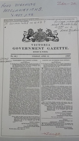
Proclamation of road district and Shires, Map of original town blocks and ad for SaleDisplays original township settlement and layoutPhotocopies, copies of maps, peterborough history, peterborough 3270 -
 Bendigo Military Museum
Memorabilia - PHOTOGRAPH WW2, Post WW2
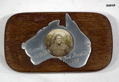
The soldier is Lionel Clarence Younghusband, initial enlistment No N199216, transferred to AIF No NX115868 age 22 years on 7.9.1942, date of death listed as 14.7.1943 while serving in 3rd ARMD DIV.Black & white photograph mounted on polished map of Australia mounted on timber rectangular stand. Photograph of a soldier in uniform.Hand inscribed on map - “Lionel NX115868 / 3rd Amd Div / AIF”photography-photographs, military history - souvenirs -
 Bendigo Military Museum
Map - MAP of NORTH AFRICA, C.1939 - 45
... Maps ...Doug Dean collection, refer cat No 4575PMap, German, North Africa, 1:500 000, all print in black and in German, map covers from “Tripolis” to Pt Said”, item appears to be two sheets glued together and laminated.maps, german, ww2 -
 Whitehorse Historical Society Inc.
Map, WW1 map of France, 08/10/1918
... Maps ...Enemy Rear Organisation map Scale 1 : 40,000non-fictionEnemy Rear Organisation map Scale 1 : 40,000maps, world war 1914 - 1918 -
 Montmorency/Eltham RSL Sub Branch
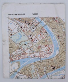
Map, Baghdad
Prepared and published by the National Imagery and Mapping Agency Copyright 2003 by the United States GovernmentPaper, coloured The map is of Baghdad Iraq city Graphic 1:25,000. WGS 84 Edition 11- NIMA Series K941 Sheet 4 Map information as of 2001map -
 Beechworth Cemetery Trust
Map - Beechworth Cemetery reproduction of original map -Secretary copy, Beechworth Cemetery
Reproduction map displaying all grave sites in Beechworth Public Cemetery. Rotunda, fountain, nursery, memorial wall, pioneer sectionmap displays the plan of grave sitesLaminated Photocopy of original cemetery map with additional information hand-written on the map. All graves at the cemetery set out in denominational sections with hand-written information on additional graves added to sections in Roman Catholic A & C, Church of England A-F, Presbyterian A-C, Methodist/Uniting B and Wesleyan A. Multidenominational hand-written note on Jews section with Trust Minutes 4.7.'83 written next to this addition. Additions hand-drawn of fountain, memorial wall, nursery and pioneer cemetery.rotunda, fountain, nursery, memorial wall, pioneer section, graves, chinese section, un-numbered grave sites, cemetery -
Beechworth Cemetery Trust
Map - Beechworth Cemetery reproduction of original map, Beechworth Cemetery Reproduction - Treasurer copy
Reproduction map displaying all grave sites in Beechworth Public Cemetery. Rotunda, fountain, nursery, memorial wall, pioneer sectionmap displays the plan of grave sitesLaminated Photocopy of original cemetery map with additional information hand-written on the map. All graves at the cemetery set out in denominational sections with hand-written information on additional graves added to sections in Roman Catholic A & C, Church of England A-F, Presbyterian A-C, Methodist/Uniting B and Wesleyan A. Multidenominational hand-written note on Jews section with Trust Minutes 4.7.'83 written next to this addition. Additions hand-drawn of fountain, memorial wall, nursery and pioneer cemetery.rotunda, fountain, nursery, memorial wall, pioneer section, graves, chinese section, un-numbered grave sites, cemetery -
Beechworth Cemetery Trust
Map - Beechworth Cemetery reproduction of original map - On site in Rotunda, Beechworth Cemetery
Reproduction map displaying all grave sites in Beechworth Public Cemetery. Rotunda, fountain, nursery, memorial wall, pioneer sectionmap displays the plan of grave sitesLaminated Photocopy of original cemetery map with additional information hand-written on the map. All graves at the cemetery set out in denominational sections with hand-written information on additional graves added to sections in Roman Catholic A & C, Church of England A-F, Presbyterian A-C, Methodist/Uniting B and Wesleyan A. Multidenominational hand-written note on Jews section with Trust Minutes 4.7.'83 written next to this addition. Additions hand-drawn of fountain, memorial wall, nursery and pioneer cemetery.rotunda, fountain, nursery, memorial wall, pioneer section, graves, chinese section, un-numbered grave sites, cemetery -
Tatura Irrigation & Wartime Camps Museum
Document, Geological Plan, Eildon Dam Site, 1945
... maps ...To record details of geological aspects of EildonA series of maps illustrating rock formations etc., locations, boundaries and planswater/irrigation, documents, maps -
Whitehorse Historical Society Inc.
Map, Map of Vermont area, c1895
... Maps ...Photocopy of part of a larger map showing the Vermont area.Photocopy of part of a larger map showing the Vermont area. Note on side 'after 1892'. Shows land holders.Photocopy of part of a larger map showing the Vermont area.maps, vermont -
 Marysville & District Historical Society
Map (Item) - Walking map, Department of Sustainability and Environment, marysville TRAILS, 07-2011
A map showing all the walking trails in and around Marysville and the district. This map was produced by the Department of Sustainability and Environment in July 2011.A map showing all the walking trails in and around Marysville and the district.ISBN 978-1-74287-122-6 (print)marysville, victoria, australia, marysville trails, department of sustainability and environment, parks victoria, steavenson falls trail, beauty spot trail, gilberts gully trail, tree fern gully trail, michaeldene trail, wilks creek trail, keppel lookout trail, lady talbot drive, taggerty cascades, the beeches, keppel falls, phantom falls, cathedral range state park, cambarville, lake mountain trails, cumberland falls, mystic mountains tourism -
Surrey Hills Historical Society Collection
Map, Contour map of Surrey Hills showing potential sites for the Telecom Tower
... maps ...The PMG / Telecom / Telstra tower was built in 1961-1963 as a relay station to support television and radio links between city and regional broadcasting stations. The tower itself was 45 m in height with a 2 storey building for equipment and staff surrounded by garden. From the beginning it was opposed by local residents. The location is said to be the second highest site in Melbourne, sometimes described as Delaney's Hill.Two A3 photocopied sheets of a map showing part of Surrey Hills, roughly between Windsor Crescent and Belmont Street (north / south) and Standard Avenue and Balmoral Crescent (east / west). The map shows contour lines and house sites, 16 of which are numbered. One sheet has been inscribed in top RH corner with notes regarding the significance of the numbers."Contour map of potential sites / for the telecommunications tower which / was eventually sited at 2. / Jock Campbell OBE was our neighbour / at 4 Theodore St when we moved into / the area in 1984. He was responsible in his / job at the PMG in deciding on the /site of the tower - Note site 5 was / behind his (& our) house. / Jack ended his career as Deputy Director / of the PMG. He sat on international committees / after WW2 to decide the split of the electronic / spectrum for radio, TV etc. / His group developed a "mobile phone" using / fixed towers but the phone was a truck full of gear."contour map, telecom tower, maps, jock campbell, john duncan campbell -
Stawell Historical Society Inc
Map, Shire of Stawell, Shire of Stawell Interim development Order, C 1930
Planning MapColoured Map of Stawell Shire showing Zoning AreasGuttering Haskings & Davey Pty Ltd Division of Urban and Environmental Planninglocal development -
 Marysville & District Historical Society
Map (Item) - Tourist Map, Tourists Resorts' Committee, Tourist's Map of Healesville Marysville and Warburton Districts, 13.10.1925
A tourist map for Healesville, Marysville and Warburton that was produced by the Tourists Resorts' Committee. This map was produced in 1925.A tourist map for Healesville, Marysville and Warburton that was produced by the Tourists Resorts' Committee.Photo Lithographed at the Department of Lands and Survey, Melbourne by W.J. Butson./ 13.10.25healesville, marysville, warburton, victoria, tourists resorts' committee, ben cairn, mount donna buang, the black's spur, the acheron valley, narbethong, launching place, tourist information, tourism, map, tourist map -
Federation University Historical Collection
Map - Plan, Ballarat Deep Leads and Mines, 1992, 1992
This is Bulletin No. 62: Deep Lead Gold Deposits in Victoria. Map No.6 Ballarat Sheet 1 of 2 The map shows geology, topography and information on mines in the following areas: one large map of the Ballarat area with five enlargements for: Sago Hill District; Scarsdale District; Pitfield Plains District; Berringa Gold Field and Rokewood District. Ballarat Mines and Deep Leads Report No.94 (Finlay and Douglas,1992) provides a summary of the Geological Survey of Victoria mines database, references and geology for most of the mines on this map. Geology Compilation: simplified from earlier Departmental mapping with minor field checking by E.N.M. Plier-Malone. Very large rectangular sheet of paper with seven coloured maps of various sizes and a small green rectangle on the bottom rhs with a map of Victoria superimposed over a poppet head. this rectangle includes information of the other maps shown. The background for these maps is white. Also includes tables of names of mine companies, name of shafts and gold production.gold mines of australia, gold mines of victoria, gold mines- ballarat and district, gold mines pitfield plains district, gold mines scarsdale district, gold mines berringa gold field, gold mines rokewood district, gold mines sago hill district, map - gold mines, map - gold mines in victoria, ballarat, pitfield, scarsdale, berringa, rokewood, sago hill, deep lead gold deposits in victoria, geological survey - gold deposits in victoria, mining, gold deposits in victoria, gold mines in victoria, rokewook, pitfield plains -
 Victorian Aboriginal Corporation for Languages
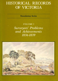
Book, Michael Cannon, Historical records of Victoria : foundation series : volume 5 : surveyors? problems and achievements 1836-1839, 1988
Reproductions of various transactions and reports dealing with the surveying history of Port Phillip, including letters, maps, illustrations, tables, and a detailed history of the surveying of Victoria.maps, b&w illustrations, b&w photographs, tablesvictorian history, port phillip, robert hoddle, monee monee creek, geelong, barwon river, werribee river -
 Peterborough History Group
Document - Maps, tourist information
Council boundaries, past tourist information, past mapsHistoric town information and mapsPhotocopies, copies of maps, newspaper clippingpeterborough history, peterborough 3270 -
Whitehorse Historical Society Inc.
Map, Broadbents map no 230, To and from Clifford Park, c1955
... Maps ...Map - To and From Clifford Park by Broadbents 1955 - 56 prepared for a scout jamboree.maps, eastern suburbs (melbourne), scout groups -
Whitehorse Historical Society Inc.
Map, Parish of Bulleen, 1892
... Maps ...Copy of map of the Parish of BulleenCopy of map of the Parish of Bulleen together with North-East portion of the Parish of Nunawading.Copy of map of the Parish of Bulleenmaps, parish of bulleen, parish of nunawading -
 Victorian Aboriginal Corporation for Languages
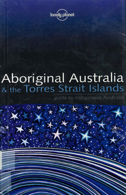
Book, Sarina Singh, Aboriginal Australia & the Torres Strait Islands : guide to Indigenous Australia, 2001
Comprehensive text with maps, coloured photos etc., dealing with all of Indigenous Australia. Provides historical references. Details of the Mabo finding.maps, b&w photographs, colour photographs, illustrations, word listsculture, travel guide, tourism, art, food -
 City of Kingston
Pamphlet - Colour, S. M. Reynolds, Estate Agent, Moorabbin Shire Hall Estate Second Section, c. 1930
Sales plan for land in the suburb of Moorabbin, bounded by South Road and Highbury Street, including Prince Street, Charming Street, Thomas Avenue and Keith Road.The developing urban area of Moorabbin within the City of Kingston. This land sale pamphlet illustrates the subdivision of land within the municipality and the changing demographic of the district as new houses are constructed close to infrastructure.Colour pamphlet advertising for private sale the Moorabbin Shire Hall Estate, Moorabbin. Incorporates a map of the estate bordered by South Road and Highbury Street, including Prince Street, Charming Street, Keith Road and Thomas Avenue.Handwritten in grey pencil on subdivision map below subdivision 63: £4 Handwritten in grey pencil on subdivision map below subdivision 66: 4 Handwritten in grey pencil on subdivision map below subdivision 80: 3. Handwritten in grey pencil on subdivision map below subdivision 81: 4 Handwritten in grey pencil on subdivision map below subdivision 83: 2 Handwritten in grey pencil on subdivision map below subdivision 96: £3 Handwritten in grey pencil on subdivision map below subdivision 97: 3 Handwritten in grey pencil on subdivision map to the left of subdivision 102: 3 Handwritten in grey pencil on subdivision map on the corner of Thomas Avenue and Highbury Street: vertical line next to a square with a cross in it.land sales, estate, moorabbin -
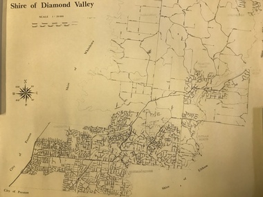 Greensborough Historical Society
Map, Shire of Diamond Valley, 1964-1994
Map of the former Shire of Diamond Valley, 1964-1994, showing the local government area from Greensborough to Hurstbridge.Map on yellowed paper.shire of diamond valley, greensborough, hurstbridge -
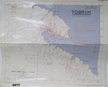 Bendigo Military Museum
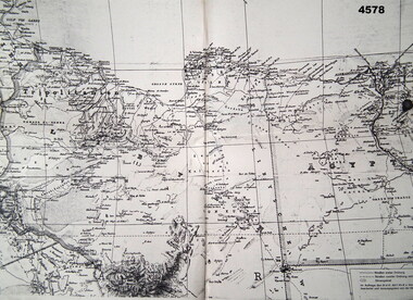
Map - MAP of TOBRUK HARBOUR, 48 Survey Coy S.A.E.C, C.1942
... maps ...Item in the Doug Dean 2nd AIF collection, refer cat No 4575PMap, laminated, “MAP T/1 SECRET TOBRUK”, shows Tobruk area and harbour, shows creeks, gullies, there are 20 marked installations in red, a rectangular section has been hand drawn on marked “E” & “F”,.At bottom RH corner, “HQ, RAF, ME, A1, 16 JULY 1942”tobruk, maps, ww2 -
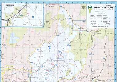 Greensborough Historical Society
Map, Shire of Eltham, 1990c
1:20000 map of Shire of Eltham, with enlargements of a number of areas.Colour map, printed both sides.shire of eltham, eltham -
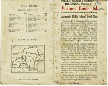 Phillip Island and District Historical Society Inc.
Booklet, Authentic Phillip Island Road Map, Pre 1960
Tourist brochure printed by the Phillip Island Printers pre 1960HistoricalSmall cream coloured brochure with details of accommodation, transport and animals. Inside is a map of the Island with numbered points of interest. There is also a plan of Cowes and drawings of animals.Visitors' Guide 6d Authentic Phillip Island Road Maptourist brochure, road map -
 Federation University Historical Collection
Photograph - coloured, Department of Lands and Survey, Portion of Victoria showing auriferous areas and mineral localities, 1935, 1935
Map included with book "Victoria: Gold and Minerals" issued by Mines Department Victoria, 1935Fold out coloured mapYellow mark indicating depositsvictoria, auriferous areas, mineral localities, department of mines, tin, antimony, copper, silver lead, tungsten, manganese, platinum, iron -
 Yarrawonga and Mulwala Pioneer Museum
Book, The Specialty Press, The New Elizabethan World Atlas Illustrated, 1952
... Maps ...Provides names of countries and their borders as they were during the 1950'sMaroon hard cover illustrated atlas. Front embossed with title and royal seal. 152 pages. Contains detailed maps of world countries in colour. Early world history and it's development and comprehensive gazetteer.Owners name written in front pagesmaps -
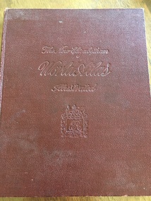
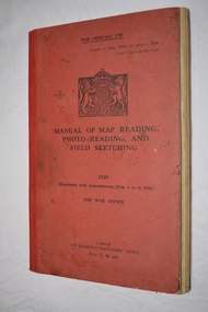 Wangaratta RSL Sub Branch
Book, Manual of Map Reading Photo Reading and Field Sketching, 1948
Official copy of War Office Manual of Map Reading Photo Reading and Field Sketching.Red bound book with black writing and British crest.Manual of Map Reading Photo Reading and Field Sketching 1929 The War Officemanual of map reading photo reading and field sketching., war office -
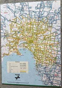 Melbourne Tram Museum
Map, The Met, "Tram and bus Routes showing destination numbers", June 1992
Titled "Tram Routes showing destination numbers". Map dated June 1992 and has been printed with The Met logo. Shows routes with route numbers, names of main destinations, roads, railway stations and rail lines, rivers, scales and Zones. Does not have the CBD insert. Same size as that of item 1099, a 1972 version. Type of map that was placed on the rear of the driver's doors of a W Class tramcar.Demonstrates a The Met produced map used in trramcars.Full colour map or poster printed on paper trimmed from original map and mounted on cardboard.Has some pen marks in the bottom left hand corner.trams, tramways, map, routes, the met