Showing 631 items
matching mine shafts
-
 Bendigo Historical Society Inc.
Map - STRUGNELL COLLECTION: UNITED HUSTLER'S & REDAN MINE, September 1913
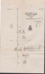
... Map, Transverse Sections N. & S. Of shaft, United... Bendigo hustler's & redan mine Underground Survey Office, Bendigo ...Map, Transverse Sections N. & S. Of shaft, United Hustler's & Redan Mine, Hustler's Line of Reef, Bendigo. Plate No. XXX (30).Bulletin No 33 Signed H.A.Whitelaw. Drawing shows the vertical shaft descending to over 976 feet and appears to show samples of connecting horizontal shafts with their respective mineral contentsUnderground Survey Office, Bendigo.map, bendigo, hustler's & redan mine -
 Bendigo Historical Society Inc.
Map - STRUGNELL COLLECTION: UNITED HUSTLER'S & REDAN & K.K.MINES, September,1913
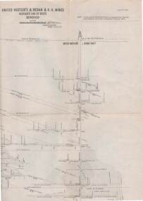
Map, United Hustler's & Redan & K.K.Mines, Hustler's Line of Reefs, Bendigo.Plat No.XXX1(31),. NOTE:- Plates 4,8,13,20,26,& 31 form a Longitudinal Section from Fortuna Hustler's to Hystler's Consols Mine. Bulletin 33.Signed H.A.Whitelaw. Drawing shows the vertical shafts descending to over 1932 feet and 1805 feet respectively .Underground Survey Office, Bendigo.map, bendigo, united hustler's, redan, k.k.mines -
 Bendigo Historical Society Inc.
Map - GEOLOGICAL MAP: BENDIGO GOLD FIELDS
GEOLOGICAL MAP - BENDIGO GOLD FIELDS - Donated by JOHN HORWOOD. Two geological maps of the Bendigo Gold fields. The maps display , reef lines, Hills, Dams and mine locations. Also Anticlines, sinclines, shafts, alluvial deposits, contours and gullys. All items are superimposed on a map of the major roads and streets of Bendigo. The maps were printed by The Victorian Minister for Mines in 1923 and re-issued in 1936. The maps have been specifically framed and donated to The Bendigo Historical Society Inc. in May 2015 for display at Specimen Cottage. John had been a student at The School of Mines- Bendigo and found them useful as a student living in Bendigo. Prior to being framed , the maps have been kept rolled up in his home. Accession Number 309/15 Were on Display at Specimen Cottage 2015 - 2020. After all items removed from SC to the BRAC in 2021 the framed maps could not be located. Search ongoing. BP 2.3.2023Victorian Minister of Minesgoldfields -
 Bendigo Historical Society Inc.
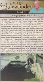
Newspaper - JACK PERRY COLLECTION: NEWSPAPER COLLAPSING SHAFTS IN MINES
... COLLAPSING SHAFTS IN MINES ...Newspaper article re collapsing shafts. Mentions Holdsworth, Eaglehawk Rd. intersection., Darling Street, Long Gully Creek, St. Lawrence Crt. Subsidences. Bendigo Bendigo Weekly 20.9.99person, individual, jack perry -
 Bendigo Historical Society Inc.
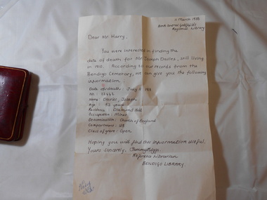
Medal - JOSEPH DAVIES COLLECTION: MEDAL 1909, 1909
Joseph Davies collection, bravery award medal awarded to Joseph Davies for an act of bravery in rescuing a fellow miner from a shaft of the Goldfields Consolidated mine Bendigo after an explosion on July 16th 1909. Circular medal with a blue and gold ribbon & pin clasp, showing 2 miners on one side and the word Courage, bust of Edward VII on other side, name Joseph Davies etched on rim. Encased in a red leather box with satin & velvet lining.trophies & awards, public events, bravery -
 Bendigo Historical Society Inc.
Photograph - MCCOLL, RANKIN AND STANISTREET COLLECTION: MONUMENT HILL MINE
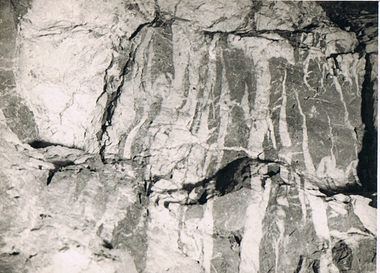
Photograph. Black and white photo- ''Monument Hill Mine No. 688'' Level north and 40' N of shaft section.Detail picture of upper limit of Upper Roof showing development of quartz spurs and stringers and formation of ss inclusions 1'' approx 1'.photograph, landscape, monument hill mine -
 Bendigo Historical Society Inc.
Photograph - MCCOLL, RANKIN AND STANISTREET COLLECTION: MONUMENT HILL MINE 655
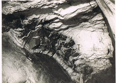
Photograph. Black and white photo - Monument Hill Mine 655. Int stope below 640' level 150' south of shaft. Picture looking south at west side of Upper Roof.photograph, landscape, monument hill mine 655 -
 Bendigo Historical Society Inc.
Photograph - MCCOLL, RANKIN AND STANISTREET COLLECTION: MONUMENT HILL MINE
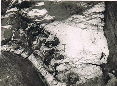
Photograph. Black and white photo - "Monument Hill Mine 655'. Int stope below 640' level 150' south of shaft. Picture of south face showing western side of upper roof. On west side is main w fault. On the face is a rock hammer. Details at ? qtz and intrusions above it.photograph, landscape, monument hill mine 655 -
 Bendigo Historical Society Inc.
Photograph - LONG GULLY HISTORY GROUP COLLECTION: TWO UNDERGROUND PHOTOS
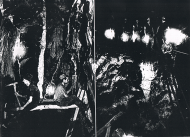
Copies of two dark black and white photos of underground mining at the Hercules mine. The left side one shows two miners facing the sides of the shaft prior to the boxing in with red gum slabs. one man is using a sledge hammer and the other is using a hand pick. The right-hand side photo This photo was either the Shenandoah or the New Chum Railway. Five men standing on a higher part are holding lamps and one man is standing on a ladder.bendigo, history, long gully history group, the long gully history group - two underground photos, hercules, shenandoah, new chum railway, victoria quartz -
 Bendigo Historical Society Inc.
Document - LONG GULLY HISTORY GROUP COLLECTION: DESCRIPTION OF PHOTOS
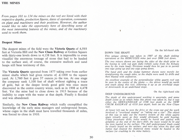
Page titled The Mines. It has the description of the two black and white photos. Down the Shaft is on the left-hand side and Deep Underground is on the right-hand side. Also on the page is some information on the Deepest Mines. Mentioned are the Victoria Quartz of 4,593 feet and closed in 1913 because of flooding. The New Chum Railway of 4.138 feet closed in 1910.bendigo, history, long gully history group, the long gully history group - description of photos, hercules, shenandoah, new chum railway, victoria quartz -
 Bendigo Historical Society Inc.
Map - LONG GULLY HISTORY GROUP COLLECTION: GEOLOGICAL MAP - BENDIGO GOLD FIELD
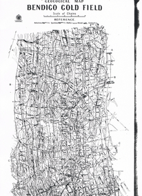
Copy of a Geological Map of the Bendigo Gold Field. Map shows Lines of Reef, Anticlines, Synclines, Shafts, Alluvial Contours Gullies and some street names. Copy is hard to read. There are two pages.bendigo, history, long gully history group, the long gully history group - geological map - bendigo gold field, mines department, h herman, lightning hill line, hustlers line, derby line, paddy's gully line, garden gully line, deborah line, sheepshead line, new chum line, nell gwynne line, british and foreign line, napoleon line, carshalton line, thistle line, christmas line, lancashire line -
 Bendigo Historical Society Inc.
Photograph - AUSTIN COLLECTION: DIGGING ELEVATOR SHAFT
Black and white photo featuring man in hard hat and wearing mining light supervising digging mining shaft at Central Deborah Goldmine,Bendigo.Man thought to be Ian Clarke.mining, business, central deborah gold mine -
 Bendigo Historical Society Inc.
Photograph - AUSTIN COLLECTION:MINE SHAFT
Black and white photo taken looking up the mining cage shaft at Central Deborah Goldmine Bendigo. Timbering and shaft support visible.mining, business, central deborah gold mine -
 Bendigo Historical Society Inc.
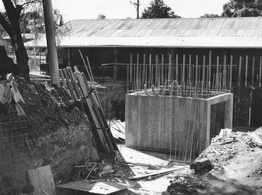
Photograph - AUSTIN COLLECTION: LIFT SHAFT
... Mine, being built. Concrete framework of shaft above ground... photograph of lift shaft, Central Deborah Mine, being built. Concrete ...Black and white photograph of lift shaft, Central Deborah Mine, being built. Concrete framework of shaft above ground. Shed in background The date 1985 is on the back.mining, business, central deborah gold mine -
 Bendigo Historical Society Inc.
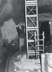
Photograph - AUSTIN COLLECTION: CENTRAL DEBORAH MINE SHAFT UNDER CONSTRUCTION
... AUSTIN COLLECTION: CENTRAL DEBORAH MINE SHAFT UNDER... in shaft. Photograph AUSTIN COLLECTION: CENTRAL DEBORAH MINE SHAFT ...Black and white photograph. Image, taken underground, shows John Jones standing alongside lift shaft under construction. Steel framework and ladder in shaft.bendigo, mining, central deborah mine -
 Bendigo Historical Society Inc.
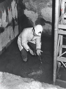
Photograph - AUSTIN COLLECTION: CENTRAL DEBORAH MINE LIFT SHAFT
... AUSTIN COLLECTION: CENTRAL DEBORAH MINE LIFT SHAFT... COLLECTION: CENTRAL DEBORAH MINE LIFT SHAFT ...Black and white photograph: image shows man, wearing white coat and hard hat with lamp, inspecting water on bottom of shaft.bendigo, mining, central deborah gold mine -
 Bendigo Historical Society Inc.
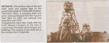
Newspaper - JENNY FOLEY COLLECTION: HEYDAYS
Bendigo Advertiser "The way we were" from Monday, February 28, 2005. Heyday: the surface view of the test shaft, plant and poppet legs of the government shaft at Fosterville (October 1900-April 1903). A pumping plant and winch were purchased from the Tyson's Reef Mine for 900 pounds and removal and assembly cost 723 pounds. Arrangements were also made with the North Stewart Company for the loan of poppet legs, the steam winch engine and buildings. The closing of the shaft led to the exodus from Fosterville.newspaper, bendigo advertiser, the way we were -
 Bendigo Historical Society Inc.
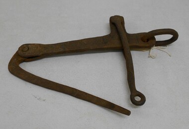
Tool - MINE SHAFT BUCKET HOOK
... MINE SHAFT BUCKET HOOK... MINES Mining equipment shaft bucket hook Metal shaft bucket hook ...Metal shaft bucket hook, used in gold mining. Metal ring on top , locking device to secure bucket on shaft of object.gold mines, mining equipment, shaft bucket hook -
 Bendigo Historical Society Inc.
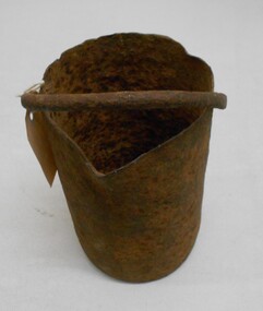
Tool - MERCURY BUCKET
Cast iron mercury bucket, used to hold mercury, potentially in the process of recovering minute pieces of gold mixed in soil and sediments. See research page for description of one process of using mercury to extract gold.gold mines, mining equipment, mercury bucket, miners used mercury in a number of ways to amalgamate gold, with each mill or battery operator having their preferred method depending on the nature of the ore. by the late 1850s the most common way of crushing goldbearing quartz ores or consolidated alluvial cements was in a stamp battery. the battery featured heavy iron stamp heads held in a frame, with each head often weighing up to 500 pounds (226 kg) or more (see msv 1880, page 45) (birrell 2005). stamp heads were lifted and dropped by a rotating overhead cam shaft driven by a steam engine or water wheel. ore was fed into a large cast-iron battery box, mixed with a steady stream of water, and pulverised by the stamp heads. in some batteries, mercury was placed in the base of the boxes to amalgamate with freed gold. the violent agitation of the mercury in the mortar box, however, could cause the mercury to break into myriad tiny globules that were carried away by the water with the tailings, thus losing a certain amount of gold in the process (thompson 1867; ritchie & hooker 1997). the water and sand slurry was splashed by the falling stamps from the box through fine mesh screens and onto inclined wooden tables below the mortar box (figure 2). the tables were covered with copper sheets or plates coated with mercury, which caught and amalgamated with a portion of the gold. the grey putty-like amalgam was periodically scraped off the sheets and retorted in a furnace to collect the gold and recover the mercury for reuse. mercury was inevitably lost from the plates, while poor maintenance resulted in further losses of gold and mercury in the tailings. mercury use and loss from gold mining in 19th century victoria. peter davies1, susan lawrence, and jodi turnbull, department of archaeology and history, la trobe university. -
 Bendigo Historical Society Inc.
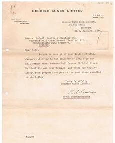
Document - MCCOLL, RANKIN AND STANISTREET COLLECTION: BENDIGO MINES LIMITED NELL GWYNNE SHAFT, 21st January, 1935
... BENDIGO Business Bendigo Mines Limited Letter from Bendigo Mines ...Letter from Bendigo Mines Limited to Mccoll, Rankin & Stanistreet re the transfer of area near Nell Gwynne shaft between Nell Gwynne and 'your company'. Signed K.A. Cameron, field superintendent.bendigo, business, bendigo mines limited -
 Bendigo Historical Society Inc.
Document - MCCOLL, RANKIN AND STANISTREET COLLECTION: MAP OF MINE LEASES SYMONDS STREET, MCKENZIE ST WEST AREA BENDIGO, 2nd September, 1936
Blue waxed linen paper map. On top' Mining District of Bendigo' Parish of Sandhurst, County of Bendigo' Map shows lease 10135, area 32.1.19; lease 10371, area 30.0.23; lease 10179 area 41.3.4; lease 10370, area 49.0.1. Map indicates gully leading into and State Rivers and Water supply reservoir, water race; siphon, shaft, dam, residential area and some residential lots marked. Streets include Holly Street, MacKenzie Street West, Symonds Street, Aspinall Street, Emmett Street; Bendigo Creek marked at bottom of map. Scale 4 chains to one inch. Map is not dated.bendigo, mining, mccoll rankin & stanistreet -
 Bendigo Historical Society Inc.
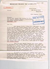
Document - MCCOLL, RANKIN AND STANISTREET COLLECTION: LETTER RE LEASE 10931, 23rd January, 1942
2 page letter from Bendigo Mines No Liability, 360 Collins Street, Melbourne to Manager, Central Nell Gwynne Gold Mining Co., N.L., dated 23rd January 1942. Letter deals with the sale from Nell Gwynne Mines, to Central Nell Gwynne Company G.M.L., No. 10931. 'located within the boundaries of this lease was the main shaft of Nell Gwynne (B.M.L. ) Mines N.L. 'previous to this sale the leases held by the Nell Gwynne company had been consolidated into G.M.L. 10931 but a machinery area No 10878 also held by the Company covering the area around the main shaft to a depth of 25ft was not included in the consolidation owing to some technical objection by the Mines Department'bendigo, mining, bendigo mines no liability -
 Bendigo Historical Society Inc.
Document - MCCOLL, RANKIN AND STANISTREET COLLECTION: GOLD MINING LEASE NORTH DEBORAH MINING COMPANY, 29th August, 1950
6 page indenture, plus plan, between King George V and North Deborah Mining Company in the Parish of Sandhurst, dated 29th August, 1950 to operate a gold mine. Indenture numbered 11231 Bendigo, Vol 331 and Folio 36457. Plan shows Hargreaves Street, Violet Street, Lily Street, Sullivan Street railway line, and leases numbered, 11230; 2107; 11062, 11033, 11013, 11219, 11175. Shafts and tracks indicated. Dam shown on lease 11013. Scale 8 CHAINS TO A INCH. Coloured key to plan shows depths, Crown Land, and surface excised. Total area of lease 48 acres, 3 roods, 22 perches.bendigo, mining, north deborag mining company, north deborah mining company, hargreaves, violet, lilly, sullivan streets. -
 Bendigo Historical Society Inc.
Document - MCCOLL, RANKIN AND STANISTREET COLLECTION: INDENTURE, GOLD MINING LEASE CROWN AND RONALD ALEXANDER RANKIN, BENDIGO, 24th June 1941
6 page document, Gold Mining Lease 11166, plus map. Indenture between Crown (King George VI) and Ronald Alexander Rankin of Bendigo, dated 24th June, 1941. Map No. 11166 Bendigo, Mining District of Bendigo, Parish of Sandhurst, County of Bendigo. Map shows lease 11166 marked in yellow with shaft, ore bins and tramway marked. Belle Vue Road , Adam Street and Griston Street shown on map. ( Golden Gully area) Dams indicated on lease holdings. Other lease holdings: 1675 T.L.9858, 10990, 11013, 11062, 11165, 11063 (void) 1172 W.R. (dam thereon) 9882 (void). Some residential lots marked along Belle Vue Road, and Adam Street. On bottom of map 21.8.41 in pencil. On last page of document : North Deborah Mining Company now the proprietor of the within described estate by transfer registered on 11th November 1914.bendigo, mining, north deborah lease, belle vue road, adams street, griston street, golden gully, ronald alexander rankin, north deborah mine. -
 Bendigo Historical Society Inc.
Document - LONG GULLY HISTORY GROUP COLLECTION: ANNALS OF BENDIGO PAGE 352 - 1907
... Ellenborough Company's Mine Belmont and Saxby Shaft Main Ellenborough ...Copy of page 352 Annals of Bendigo 1907. Items mentioned are: Water Mains Burst, School of Mines, A Cool Summer, State Elections, Bendigo Firemen, Easter Fair and Hospital Sunday, Fires, Superintendent Sainsbury, Sensational Robberies, New Picture, Senior Cadets and Bendigo's Prosperity.bendigo, history, long gully history group, the long gully history group - annals of bendigo page 352 - 1907, south new moon, specimen hill, south p. of wales, do tribs, united ulster, victoria consols, virginia, garden gully united sandheap, temperance hill, ellenborough, company's mine, belmont and saxby shaft, main ellenborough shaft, mr donald clark, school of mines, mr j r v anderson, messrs a roberts and sons, mr w h thompson, mr j sarvaas, mr b sluyterman, t glass, d smith, t tunnecliffe, a s bailes, j semmens, h kirkwood, a hicks, d r lazarus, r h s abbott, w orr, bendigo easter fair, hospital and asylum, r e walters, j sideborrom, oldfellows hall, l a lyons, mr peterson, unity mine, rose of australia hotel, superintendent sainsbury, superintendent r c molyneux, melbourne mint, e m pascoe, messrs roberts osborne and co's bacon factory, c f roberts, the golden wedding (a painting), bendigo art galery, carl hoff, senior cadets battalion, lieutenant t r henderson -
 Bendigo Historical Society Inc.
Document - LONG GULLY HISTORY GROUP COLLECTION: GOLD MINING
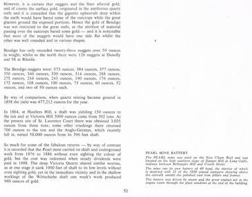
... Court Anglo-German Pearl Mine Victoria Quartz Wittschiebe Shaft ...Copy of page 52 from a book. Mentioned are nuggets of gold. Some large Bendigo nuggets and their weight in ounces are mentioned, but no names of the nuggets. Some yields from shaft mining are also mentioned. The Pearl Mine and the Victoria Quartz did a lot of work without sighting any gold, while nearby at the Wittschiebe shaft there was a good find. There is also a short piece about the Pearl Mine Battery. It belongs to photo that was on the next page.bendigo, history, long gully history group, the long gully history group - gold mining, hustlers hill, victoria hill, st laurence court, anglo-german, pearl mine, victoria quartz, wittschiebe shaft, new chum reef, danger hill, belltopper hill -
Bendigo Historical Society Inc.
Map - GEOLOGICAL MAP OF BENDIGO GOLD FIELD
Two framed laminated maps (a,b) of Bendigo goldfield reef lines, map (b) is a continuation of the reef lines in map (a). On map(a) written in black on top: 'Geological Map, Bendigo Gold Field', Scale of chains, anticlines, synclines, shafts, alluvial and contours marked. Map (b) is continuation of (a). Written on the bottom RH corner of map: 'Prepared in 1923 in the Bendigo Office Mines Department under the direction of H. Herman, Director of Geological Surveys, from surveys by H.S. Whitelaw, Fiield Geologist, assisted by E.S. Usher & J. J. Moore. Re-issued in 1936.'H. Herman, Director of Geological Surveys, from surveys by H.S. Whitelaw, Fiield Geologist, assisted by E.S. Usher & J. J. Moore. Re-issued in 1936.'bendigo, mining, geological map. -
 Bendigo Historical Society Inc.
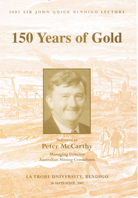
Book - LONG GULLY HISTORY GROUP COLLECTION: 150 YEARS OF GOLD
Book titled 150 Years of Gold delivered by Peter McCarthy, Managing Director Australian Mining Consultants at La Trobe University, Bendigo on 26 September, 2001, the 2001 Sir John Quick Bendigo Lecture. Book cover, inside and out has a beige copy of a wood engraving of Hustlers Reef, Sandhurst with a tan tone photo of Peter McCarthy on the centre front. Mining is mentioned from the late 1840s to the present day. In the back is a career history of Peter McCarthy and a short life story of Sir John Quick. Also in the back is a list of past lectures from 1994 to 2000.bendigo, history, long gully history group, the long gully history group - 150 years of gold, peter mccarthy, australian mining consultants, la trobe university bendigo, robertson hyetts, sir john quick, quick hyett and rymer, quick and hyett, national library of australia, charles joseph la trobe, james gumm, hargreaves, melbourne argus, henry frenchham, the times, gibbons, james esmond, dr barker, thomas hiscock, alfred clarke, geelong advertiser, wat tyler, dunlop and regan, commissioner doveton, sub commissioner armstrong, captain dana, argus, armstrong, stewart gibson, margaret kennedy, convict's prevention act, micky o'halloran, throckmorton, anti-gold-license association, g e thomson, dr jones, 'captain' edward brown, eureka rebellion, sir john quick, mark twain, australian federation, mining exchanges, alfred deakin, the amalgamated miner's association, robert clark, britian's national miners' association, silicosis, tuberculosis, walter summons, bendigo amalgamated mines, great war, gold mines of australia, bendigo mines limited, nell gwynne, carshalton shaft, napoleon shaft, george lansell, fortuna villa, the four deborah mines, world war two, central deborah, north deborah, william kelly, the edwards works, newstead dredge, jim crow dredge, adelong dredge, calder freeway, bendigo mining nl, randolph bedford, cra ltd, sovereign hill, ballarat historical park association, rmit, melbourne university, macquarie university, australasian institute of mining and metallurgy, institution of engineers australia, mineral industry consultants association, joint ore reserves committee, ceo institute, anthea mccarthy, michele matthews, sir john quick committee, city of greater bendigo, the hon justice michael kirby, mr don blackmore, murray darling basin commission, dr janet mccalman, australian research council, dr john white, visy industries, dr al luloff, mrs delys sargeant, the rt hon ninian stephen -
Bendigo Historical Society Inc.
Document - VICTORIA HILL - SELF TOUR OF GOLDFIELDS NO 1
Two copies (a & b) of a Royal Historical Society of Victoria, Bendigo Branch Self Tour of Goldfields No 1. The guide is to enable the tourist to locate and see for himself some of the gold mining area of Bendigo. Mines mentioned are: Deborah, North Deborah, Central Deborah, The Fortuna Hustlers, Hustlers Royal Reserve (City Mine), Great Extended Hustlers, The Hustlers Reef, Lansell's Comet, The United Hustlers and Redan, Garden Gully United, Central Nell Gwynne, The Old Chum, The New Chum and Victoria, The Lazarus, The New Chum United, The New Chum Consolidated, The Garibaldi, Advance, Lansell's 180, The Victoria Quartz, North Old Chum, The Ironbark, The Hercules, The Carlisle United, The Mungo Group, The Ellenborough, The St. Mungo, The Lady Barkly, South St. Mungo. Notes also include wages at the Fortuna Hustlers in 1906 and 1907, gold yield, depth of shaft, Dividends and Calls. Notes compiled by Mr. A. Richardson.document, gold, victoria hill, victoria hill, self tour of goldfields no 1, deborah (big deborah), north deborah, central deborah, the fortuna hustlers, hustlers royal reserve (city mine), great extended hustlers, the hustlers reef, lansell's comet, the united hustlers and redan, garden gully united, central nell gwynne, the old chum, the new chum and victoria, the lazarus, the new chum united, the new chum consolidated, the garibaldi, advance, lansell's 180, the victoria quartz, north old chum, the ironbark, the hercules, the carlisle united, the mungo group, the ellenborough, the st. mungo, the lady barkly, south st. mungo, hustlers hill, new chum hill, jonathan harris, j hustler, messrs latham and watson, buckell & jeffrey, camp hill school, mechanics institute eaglehawk, duke of edinborough, geo lansell, the k k shaft, williamsons, little's claim, rosalind park, mr pryor, gold mines hotel, burrowes and sterry, bonatti, menzies, hildebrant and koch's, ellesmere, p m g repeater station, mr lazarus, mt alvernia hospital, mr clarke magee, rae's, jeweller's shop, hopetoun band room, manchester arms hotel, wattle gully mine chewton, long gully post office, 'pope pius' roman catholic church, kentish, mr j b watson, california gully state school, duke of edinborough, new st mungo, duchess tribute, south devonshire, duchess of edinborough, west united devonshire, united devonshire, princess alexandra, hopewell, miners' phthisis, bendigo goldfields, mr a richardson -
Bendigo Historical Society Inc.
Document - VICTORIA HILL - BENDIGO BRANCH HISTORICAL SOCIETY - MINE TOUR
Typed notes for a tour of the area. Areas mentioned are: Hospital Hill, The Central Deborah Mine, New Chum Railway Mine, The Rocks, New Chum Hill, Victoria Hill, Central Nell Gwynne, Rae's Open Cut, Housing Commission Homes and Latham and Watson's. Description of machinery at the Central Deborah Mine, yields, dividends, depth of shafts and directions to get ot the various places is included.document, gold, victoria hill, victoria hill, bendigo branch historical society mine tour, all saints church, joseph la trobe, bendigo's first hospital, sacred heart cathedral, the central deborah mine, city council, londonderry west shaft, new red, white and blue consolidated (big blue), a roberts & sons, big deborah, the new golden fleece, new chum goldfields, central wattle gully mine chewton, virginia consols, black's quarries coldstream, thompson's engineering and pipe co ltd castlemaine, new chum railway mine, golden square methodist church, the rocks, e j dunn, gold monument, shamrock mine, mt alvernia hospital, j b lazarus, john brown knitwear factory, gold fmines hotel, david sterry, new chum hill, fortuna villa, geo lansell, theodore ballerstedt, a h q survey regiment headquarters, old chum mine, central nell gwynne, rae's open cut, theodore ballerstedt, new chum syncline, little 180 mine, victoria quartz, wittcheibe's 'jeweller's shop', adventure, advance, cinderella, j n macartney, bendigo goldfields registry 1870, wm rae, johnson's devonshire mine, snobs hill mine, ellenborough mullock heap, belmont mullock heap, sadowa, st mungo, united devonshire, mechanic's institute, log lock-up, court house, j b watson, housing commission homes, hustlers hill, latham and watsons', the great extended hustlers, a richardson