Showing 444 items
matching mining site
-
 Stawell Historical Society Inc
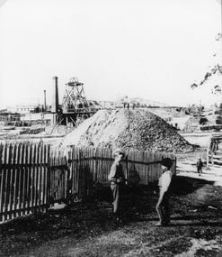
Photograph, Magdala cum Moonlight Mine looking from Walker Street
Magdala cum Moonlight Mine. Two boys in front of view of mullock heap and mine site with poppet head and smoke stacks in rear of photo.Mine and waste heap with two boys and fence in foregroundstawell gold mining -
 Stawell Historical Society Inc
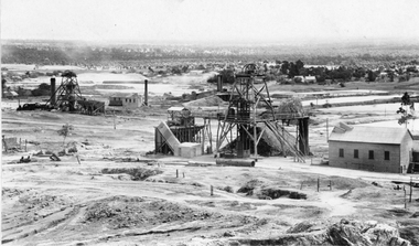
Photograph, Sloane's & Scotchman United Mining Co in Stawell looking North West with Poppet Heads & Sheds 1914 -- Photo & Colured Painting
Poppet Heads, Ore bin Winding Engine Shed Sloane's & Scotchmans United Quartz Mining Co looking North West Moonlight dams in background. Mine on left is the old Extended mine where the winding engine shed has been destroyed by fire. Just behind that is the Winding Engine Shed of the Oriental Mine without the poppet head.View of two mine sites with poppet heads and engine sheds. Settling dams in background.mining, panorama -
 Stawell Historical Society Inc
Photograph, Sloane's & Scotchman United Quartz Mining Co Looking East up upper Main Street c1916
Sloane's & Scotchman Mining Co Looking East up upper Main Street The back view of the Ore Bin can be seen. Street view looking uphill towards mine site. Cows grazing at right.stawell mining -
 Stawell Historical Society Inc
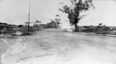
Photograph, Sloane's & Scotchman United Quartz Mining Company remains of Poppet Head, Chimney & Engine Mounts
... and Engine Mounts. Stawell Mining Derelict mine site at upper main ...Sloane's & Scotchman Mining Co remains Poppet Head Chimney and Engine Mounts.Derelict mine site at upper main street. Engine housing brickwork and Chimney at right partly demolished.stawell mining -
 Stawell Historical Society Inc
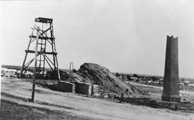
Photograph, Sloane's & Scotchmans United Quartz Mining Company Remains with collapsed Poppet Head and Engine Mounts
... Poppet Head and Engine Mounts. mining Derelict mine site ...Sloane's & Scotchman Mining Co remains with collapsed Poppet Head and Engine Mounts.Derelict mine site with engine housing brickwork and Mullock heap. mining -
 Stawell Historical Society Inc
Archive - CD/DVD, Gold Mining Relics of the Past - Surface and underground. Plan view of underground mine. Photographs of various mine sites. Underground workings of various mines, 2003
stawell, mines, relics, stokes, timbers -
 Federation University Art Collection
Painting, Claim of the Waterloo Mining Co, 1909
The painting is thought to be a copy of a similar earlier work. An Australian flag flying on a flagpole is an interesting addition. The puddlers depicted in this painting were the Kneeshaw Brothers. This item is part of the Federation University Art Collection. The Art Collection features over 2000 works and was listed as a 'Ballarat Treasure' in 2007.Framed watercolour of the Waterloo Mine, Ballarat. This site is now known as Lydiard Street South, and the church on the hill is the former Wesleyan Church. After the church was abandoned it was purchased by the Ballarat School of Mines and used as a Museum for many decades. Today the Federation University Hairdressing school uses the building for their classes. art, artwork, waterloo mine, ballarat, mining, wesley church, lydiard street, kneeshaw, kneeshaw brothers, lydiard street south, ballarat school of mines -
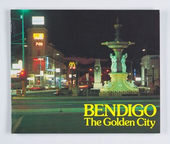 City of Greater Bendigo - Civic Collection
Booklet, City of Bendigo, Bendigo The Golden City, Unknown
Souvenir publication promoting Bendigo. Features photographs accompanied by a brief history of popular sites such a Charing Cross, the Post Office and The Law Courts, Conservatory and Gardens, Lake Weroona and the Bendigo Easter Fair.Full colour, twelve page promotional publication. Inside front cover includes a brief history of Bendigo from 1840's onwards, with an emphasis on the mining history.city of greater bendigo tourism -
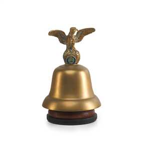 City of Greater Bendigo - Civic Collection
Ceremonial object - Eaglehawk Bell, unknown
The Borough of Eaglehawk was a local government area which covered the northwestern suburbs of the regional city of Bendigo and covered an area of 14.54 square kilometres (5.6 sq mi). Eaglehawk was first incorporated as a borough on 29 July 1862. It had nine councillors, who represented the entire borough. Councillors met at the Town Hall (incorporating the Star Cinema) at the intersection of Sailors Gully Road and Loddon Valley Highway, Eaglehawk. The Town hall has always been the centre of the Borough's activities and was built in 1901 on the site of an earlier town hall which had stood on the location since 1865. The Victorian Heritage Database notes: "The present building replaced this earlier building and was opened on 14 August 1901. The architects were the Melbourne firm of Wilkinson and Permewan. As a much larger and more sumptuous building of brick and stone featuring a central clock tower, the new hall reflected prevailing architectural fashion and was a remarkable investment for a town consisting predominantly of poor mining families. The condition of the town hall is substantially as built. The design is almost identical to the Castlemaine Town Hall." On 7 April 1994, the Borough of Eaglehawk was abolished, and along with the City of Bendigo, the Rural City of Marong and the Shires of Huntly and Strathfieldsaye, was merged into the newly created City of Greater Bendigo.Brass bell with eaglehawk topper / handle on timber stand. The lower front section of the topper has the Borough of Eaglehawk seal attached. No hallmarks or makers stamps visible.borough of eaglehawk, star cinema -
Tarnagulla History Archive
Reef Mining NL folder with photo and photocopy
David Gordon Collection. Folder contains a photo (dated 1997) of workers underground, photocopy is of a historic photograph of men at a mine site (original being THA-2020.0091). -
 Wodonga & District Historical Society Inc
Photograph - North-Eastern Gold Days, 1900
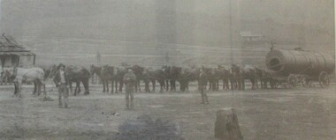
Bethanga was established as a result of the discovery of gold. Gold was first reported in the Bethanga area in 1852. Before 1876 gold mining in the Bethanga district occurred to the north of the town and was known as the 'Talgarno diggings'. Reports of alluvial gold date back to 1852. Early gold fields were worked at Ruby Creek, Gold Creek and Jarvis Creek. The opening of the Bethanga goldfields began with the discovery of a gold-bearing quartz reef on New Year’s Day 1876. The 'Gift' mine site is located southeast of Kurrajong Gap lookout to the west of Bethanga township. The Great Eastern Copper Smelting Works was opened in 1878. Due to the nature of the gold-bearing quartz reef, the gold was difficult to extract, and the discovery of copper led to a change in focus. It was not until the early 1890s that an efficient technique for extracting the gold from the ore was discovered, and once again gold became the focus, with copper as a by-product. Bethanga was removed from the official list of goldfields in 1912, however some mining activity has taken place since.This image reflects an important time in the development of Bethanga and Northeast Victoria.A large mounted and framed image of horse teams and their owners hauling a large boiler to the gold mine near Bethanga, Victoria. On label beneath image: "North-eastern "Gold Days"/ Combined teams hauling a boiler to Bethanga Mines, 1900. Teamsters - Mr. G. Pearce, W. Chapple, G, Bannon." Donated by Ron Saunders and Barbara Cadman"bethanga, gold mining northeast victoria, gold mining bethanga, bethanga history -
 Bendigo Historical Society Inc.
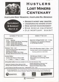
Document - GREAT EXTENDED HUSTLERS GOLD MINE: LOST MINERS FLYER FOR CENTENARY OF MINE DISASTER
On May 2nd 1914, 7 miners were killed in a dynamite explosion in the Great Extended Hustler's Gold Mine. It was Bendigo's worst mining disaster and although an inquest found it was an accident, no cause for the explosion was found.Advertising flyer for an event held on May 3-4 2014, to mark the centenary of the mine disaster that killed 7 minersat the Great Extended Hustlers mine. Other activities included a Specimen Cottage exhibit; guided walks around the Hustlers Reef Reserve; displays on site and talks by various speakers on the mine disaster and mining technology. Event was organised by the Bendigo Historical Society in conjunction with the Hustlers Reserve committee. -
 Bendigo Historical Society Inc.
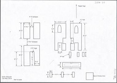
Document - CENTRAL DEBORAH GOLD MINE: NORTH DEBORAH GOLD MINE
BHS CollectionSeven page document with diagrams of the remnant footings of the North Deborah Gold Mine, the South Deborah Gold Mine, Deborah Extended, Deborah Consolidated, Deborah United Deborah Associated. Measurements of footings recorded but sites are not to scale. Researched and drawn by Philip Wilkin and Kay MacGregor, 2014.bendigo, mining, central deborah gold mine -
 Bendigo Historical Society Inc.
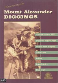
Book - BOOK: DISCOVERING THE MOUNT ALEXANDER DIGGINGS - MOUNT ALEXANDER DIGGINGS COMMITTEE, 1999
BHS CollectionSoftcover book with purple cover and a detail from a sepia photograph of miners in Forest Creek in 1858. The book is a guide to the Mount Alexander goldfields with historical notes, sites to visit, suggested tours, drives and walks. The areas covered include Chewton, Castlemaine, Campbells Creek, Vaughan, Fryerstown Newstead and Maldon. Indigenous stories are also included.Mount Alexander Diggins Committeegoldfields, gold mining, mount alexander, castlemaine, campbells creek, maldon, indigenous stories -
 Bendigo Historical Society Inc.
Document - MCCOLL, RANKIN AND STANISTREET COLLECTION: EAST CLARENCE GOLD MINING CO NL, 1932 - 1946
Document. Envelope contains: - Insurance Policies, Receipts Hire agreement for Steam driven air compressor and site map and specifications. Tender for new compressor, treasure Bonds and Lease Agreements. Envelope with a 2 pence red postage stamp with the profile of King George 5th and a crown above his head addressed to Mrs. C. Russell of 7 Willowbank Road N7, Melbourne. War Damage Commission receipts. Correspondence from The English Scottish & Australian Bank Limited regarding Treasury Bonds. Receipt for Boiler Test, Certificate of inspection of Boiler.McColl, Rankin & Stanistreetorganization, business, gold mining - legal, mccoll, rankin & stanistreet, east clarence gmc nl, gold mining, insurance policies, treasury bonds -
 Bendigo Historical Society Inc.
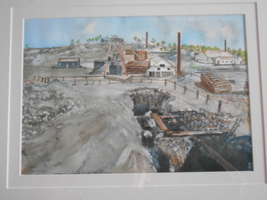
Painting - JOHN HALL COLLECTION: NEW CHUM MINE
BHS CollectionWatercolour by John Hall, in gold timber frame, cream mount board. Painting shows the New Chum Mine site. In foreground, open shaft with timber supports, in background mining chimneys and poppet head.John Hall, Eaglehawkbendigo, mining, new chum mine -
 Bendigo Historical Society Inc.
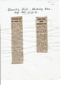
Newspaper - Quartz Hill Working Bee, 1967
Quartz Hill is situated on the Sheephead line of reef and is situated just south of where the Red, White and Blue Consolidated Gold Mine operated. Two newspaper cuttings affixed to lemon backing sheet. Written on top in black pen: 'Quartz Hill Working Bee, Bdgo Adv. 11.12.67' Cutting one, 'Working Bee on Mine Site' with 7.12.67 written across the top, describes an appeal to get volunteers to clear the site of former mines on Quartz Hill. This is anticipated to 'clear the site of accumulated debris and clean out the two large adits driven into the hill and thus make the site a 'tourist visiting spot'. Cutting two, 'Many Miss Mine Working Bee' dated 11.12.67, describes the poor response to the working bee. ' Members of the Tourist Development Association and the Town Clerk, Mr. A.J. Watts, cleared 175 feet of the Northern tunnel and cut an entrance way and steps in the Southern tunnel of the New Blue Mine area in the first stage of the mining project. Mr. J. Stanistreet said last night he was most disappointed. He said: 'apparently we picked the wrong time of the year'.mining, sandhurst, new blue consolidated gold mine, red white and blue consolidated gold mine, quartz hill, sheepshead reef line, a.j. watts, j. stanistreet, bob long -
Bendigo Historical Society Inc.
Document - Phillip's Water Wheel, Diamond Hill, Bendigo, 1876
'Messrs. George Phillips and Richard Williams erected a water wheel crushing machine near the site of the Old Albert shaft at Diamond Hill'. ( Bendigo Advertiser 4th June, 1890). The lack of water available for the venture from the water race caused much controversy in the following years. There was only enough water available in July 1890, to allow the company to operate three head of a ten head stamper. The site of the water wheel is still visible on the side of the water race at Diamond Hill. Mr. Geo Phillips held 1000 shares in the float of the Kangaroo Hydraulic Crushing & Gold Mining Company. He was one of the largest shareholders. (Victorian Government Gazette 72 Page 2260, 1893) Black and white photocopy. Image shows the Phillip's Water Wheel on Diamond Hill, Bendigo. Weatherboard building on right hand side of image, brick chimney on side of building. Large water wheel in cutting directly alongside building. Two men standing in between water wheel and building, one man standing on landing of waterwheel.mining, sandhurst, phillip's hydraulic waterwheel, stafford gold mine, diamond hill, george phillips, richard williams -
 Bendigo Historical Society Inc.
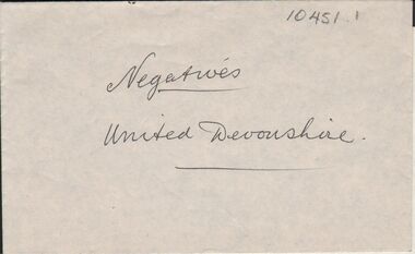
Negative - ALBERT RICHARDSON COLLECTION: DEVONSHIRE GROUP OF MINES
Envelope containing 2 negatives. On outside of envelope 'United Devonshire' Negatives show mine site. Negatives not scanned.bendigo, mining, devonshire group -
 Bendigo Historical Society Inc.
Document - Phillip's Water Wheel, Diamond Hill, Bendigo, 1876
'Messrs. George Phillips and Richard Williams erected a water wheel crushing machine near the site of the Old Albert shaft at Diamond Hill'. ( Bendigo Advertiser 4th June, 1890). The lack of water available for the venture from the water race caused much controversy in the following years. There was only enough water available in July 1890, to allow the company to operate three head of a ten head stamper. The site of the water wheel is still visible on the side of the water race at Diamond Hill. Mr. Geo Phillips held 1000 shares in the float of the Kangaroo Hydraulic Crushing & Gold Mining Company. He was one of the largest shareholders. (Victorian Government Gazette 72 Page 2260, 1893) Black and white photocopy. Image shows the Phillip's Water Wheel on Diamond Hill, Bendigo, date unknown but must be in 1890's. Three men and a dog standing in front of a weatherboard shed, brick chimney on side. Large water wheel on left hand side of image. Three images, 2008, showing former site of water wheel on channel, after heavy rain in district caused dry channel to run. mining, sandhurst, phillip's hydraulic waterwheel, stafford gold mine, diamond hill, george phillips, richard williams -
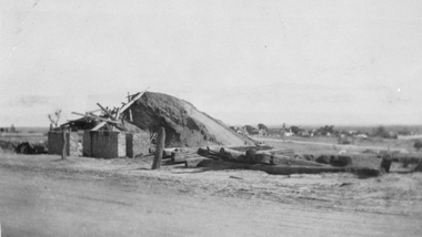
 Bendigo Historical Society Inc.
Photograph - MINE SITE
BHS CollectionBlack and white photograph of the Hustler's Mine as a part of the Bendigo mining landscape with the valley in the background. On the left hand side is the poppet head, chimney and mining sheds and in the foreground is the bare stony earth.bendigo, mining, hustler's royal reserve mine, bendigo, mines and mining, mines, mining, gold mining, gold, gold mines, place, bendigo mines -
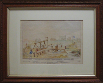
Clunes Museum
Photograph, CLUNES 1860, CIRCA 1860
COLLAGE - CLUNES IN THE 1860's SIX REPRODUCED PHOTOGRAPHS MOUNTED IN WOODEN FRAME WITH BOLD EMBOSSED TRIM. CRITERION QUARTZ MINING COMPANY, PORT PHILIP & COLONIAL GOLD MINING COMPANY, VICTORIA QUARTZ MINING COMPANY. VIEW OF CAMP HILL , VIEW OF PORT PHILIP MINE SIGHT, VIEW OF THE LEVEL SITE OF BATTERY SEEN ON THE SITE ALONG STATION FLAT ROAD.local history, photographs, mining and township -
 Bendigo Historical Society Inc.
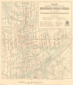
Map - DEPARTMENT OF MINES VICTORIA : PLAN SHOWING PORTION OF THE BENDIGO GOLD FIELD
Department of Mines Victoria. Plan showing portion of the Bendigo Gold Field. On the back is written, in ink, J. J. Tyler 1937 Northern Area. (He was a teacher at Bendigo High - see donation notes). Across the bottom of the map is written ' M. Hill cr. Myrtle & Barnard' .The named reef lines have been numbered with ink across the bottom of the map. The gullies have been coloured with green pencil and a red pencil line is drawn through the western side of the map. Additional information: anticlinal axial lines at surface, alluvial workings, shaft sites, area of Main Goldfield, Deepest mine workings, Gold output of field to 1935, and Dividends paid 1870 - 1935.bendigo, gold mining, bendigo gold field. gold mining. tyler, j. j. -
 Eltham District Historical Society Inc
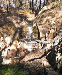
Photograph - Digital Photograph, Marguerite Marshall, One Tree Hill Mine, Smiths Gully, 8 June 2006
Gold was discovered on One Tree Hill in 1854. The site has been worked intermittently until fairly recent times. Published: Nillumbik Now and Then / Marguerite Marshall 2008; photographs Alan King with Marguerite Marshall.; p53 Though still a working mine, One Tree Hill Mine at Smiths Gully, now stands in a tranquil reserve surrounded by bush and native animals - in contrast to its heyday. In the mid 19th century, when the mine was part of the Caledonia Goldfields, hundreds of men in search of their fortune worked the alluvial gold in the Yarra River, its tributaries and the reefs that made up the goldfields. Miner Stan Bone, assisted by Wilfred Haywood, is the last of the independent gold miners in the area and still uses the quartz crushing battery as miners did when gold was first discovered in the area in 1851.1 Stan, who is the last of six generations of miners in his family, was aged 17 when he began mining on his father Alex’ mine, The Golden Crown in Yarrambat. These days, after blasting the gold-bearing rock in Mystery Reef, one of the four reefs at One Tree Hill, Stan transports it around five kilometres by tip truck to the Black Cameron Mine for crushing. There he uses water from the waterlogged mine, (which still contains gold), as the Happy Valley Creek at One Tree Hill is usually dry.2 The One Tree Hill Mine has been worked for close to a century since it opened around the late 1850s.3 The Swedish Reef was its most productive reef and one of the largest in the area. Around 1859, extractions included 204 ounces (5.8kg) of gold, won from 57 pounds (26kg) of stone.4 Then during World War Two, Stan’s uncle, Bill Wallace, and Alex Bone, closed the mine. In 1973, Stan, with his Uncle Bill, reopened the Black Cameron Mine and worked there until 1988. Stan resumed mining One Tree Hill in 1998. As late as the 1920s gold was picked up by chance! When crossing a gully on his way to vote at the St Andrews Primary School, Bill Joyce picked up some quartz containing gold. This site was to become the Black Cameron Mine. The Caledonia Diggings, named after Scotland’s ancient name by local Scots, began around Market Square (now Smiths Gully) and included Queenstown (St Andrews), Kingstown (Panton Hill) and Diamond Creek. There were also poorer bearing fields in Kangaroo Ground and Swipers Gully (now Research). * None of these compared in riches to the Ballarat and Bendigo fields5, but the Caledonia Diggings continued intermittently for close to 100 years. Gold was discovered in Victoria following a bid to stem the disappearance of much needed workmen to the New South Wales diggings. Several businessmen offered a reward of £200, for the discovery of gold within 200 miles (322 km) of Melbourne. Late in June 1851, gold was first discovered at Andersons Creek, Warrandyte. Then in 1854, George Boston and two other men discovered gold at Smiths Gully. Gold transformed the quiet districts, with a constant flow of families and vehicles on the dirt tracks en route to the Caledonia Diggings. Three thousand people worked the gullies in Market Square, including about 1000 Chinese miners. The square established its own police, mining warden, gold battery, school, shops and cemetery and grog flowed. Market Square flourished until the middle 1860s. Bullocks transported quartz from the Caledonia Goldfields to the crushing machinery at the Queenstown/St Andrews Battery, near Smiths Gully Cemetery. It was destroyed by bushfire in 1962. By the late 1850s, most early alluvial fields were in decline, but minor rushes continued until around 1900 and some until the early 1940s. Some miners did well, although most earned little from their hard labour in the harsh and primitive conditions.6 But according to historian, Mick Woiwod, the gold fields helped to democratise society, as individuals from all walks of life were forced to share experiences, and the ability to succeed, depended less on inherited wealth or social rank.This collection of almost 130 photos about places and people within the Shire of Nillumbik, an urban and rural municipality in Melbourne's north, contributes to an understanding of the history of the Shire. Published in 2008 immediately prior to the Black Saturday bushfires of February 7, 2009, it documents sites that were impacted, and in some cases destroyed by the fires. It includes photographs taken especially for the publication, creating a unique time capsule representing the Shire in the early 21st century. It remains the most recent comprehenesive publication devoted to the Shire's history connecting local residents to the past. nillumbik now and then (marshall-king) collection, gold mining, one tree hill mine, smiths gully -
 Eltham District Historical Society Inc
Photograph - Digital Photograph, Alan King, Site of the Diamond Creek Gold Mine, 28 December 2007
The largest gold mine in the area originated from a find in 1862. The mine was closed January 20, 1915 when a fire destroyed nearly all the above ground plant. Published: Nillumbik Now and Then / Marguerite Marshall 2008; photographs Alan King with Marguerite Marshall.; p75 Beneath Mine Hill, as locals call it, runs a network of tunnels once of central importance to the fledgling township of Diamond Creek. These are relics of gold mines, which transformed early Diamond Creek.1 The tiny settlement of about 20 families soared to more than 200 because of gold. For around 50 years, from 1862, gold mining was Diamond Creek’s major source of employment. On September 7, 1854 The Argus newspaper reported a find of a four pound (1.8kg) gold nugget in Nillumbik (an early name for Diamond Creek). Exactly where, is not known.2 The largest mine in the district, the Diamond Creek Gold Mine, apparently originated from a find in 1862. It is said Joe and Dave Wilson were visiting former tailor then cook, Charles Orme, at the southern end of Fraser Street. Sitting on a stump outside the front gate on land belonging to Dr A. E. Phipps the Wilsons found a vein of gold-bearing quartz, which led to the discovery of four quartz reefs varying in width to eight inches (20cm), running north and south. A reef found at the foot of the hill opposite Challenger Street became the Union Mine. This reef was traced south to Allendale Road where a small mine began operations.3 Other smaller mines later operated as well. Dr Phipps immediately began to mine and also built the Diamond Reef Hotel as a boarding house for miners. But Charles Orme, who owned the land alongside, leased his mine to Dr Phipps probably because of insufficient funds and business skills. By mid 1865 the mine had produced 2530 ounces of gold – a 100% profit on the original outlay. Of course there were problems. When the local dam dried up a Blake pump was installed to draw water from the creek. The Union Mine operated under the Diamond Creek Gold Mine management except when disputes sometimes resulted in separate management. However disagreements had to be resolved as the Union Mine depended on Diamond Creek Gold Mine pumps to remove underground water from common reefs. In 1912 the main shaft of about 380 yards (350m) employed 200 men recovering an average of 5000 ounces (141.7kg) of gold a year. But not everyone did well out of gold. Records of failed mining companies in the Victorian Public Record Office, reveal that owner Dr Phipps leased his Right to others. Companies came and went over the next 40 years, most sponsored by Melbourne businessmen who sold shares to gullible locals and then became insolvent. Although there were some good profits, financial returns were haphazard until 1905. Some local residents, who were share holders in short- term companies, became well-known names in modern Diamond Creek such as Scott, Haley, Butler, Alder, Ryan, Wadeson, Reeves, Alston, Paul and Edwards. Gold mining was brought to a disastrous end on January 20, 1915 at 3 pm, when fire destroyed nearly all the above-ground plant. Fortunately no lives were lost. But reopening the mine was almost impossible because of the increasing depth of water in the main shaft. The closed mine destroyed the livelihood of 200 families and the debris took many years to clear.4 In 1946 the Diamond Creek Gold Mine was reopened by the Golden Hind Mining Company, but money ran out before the 600 feet (182.8m) or so of water could be removed. Gold remains in the mine but enormous capital would be needed to buy the land, equipment and to remove the water. Today 12 known sealed shafts along the ridge of the hills on private property extend west for around one kilometre from the corner of Fraser and Haley Streets, crossing Norma and Fyffe to Dering Streets. As recently as 1987, heavy rains revealed a former Union Mine shaft in the Georgiadis family Fyffe Street back yard.5 Allendale Mine, south of Allendale Road, is still open and one of the Union Mine’s main drives (horizontal excavation) remains unsealed, on the Creek Reserve.This collection of almost 130 photos about places and people within the Shire of Nillumbik, an urban and rural municipality in Melbourne's north, contributes to an understanding of the history of the Shire. Published in 2008 immediately prior to the Black Saturday bushfires of February 7, 2009, it documents sites that were impacted, and in some cases destroyed by the fires. It includes photographs taken especially for the publication, creating a unique time capsule representing the Shire in the early 21st century. It remains the most recent comprehenesive publication devoted to the Shire's history connecting local residents to the past. nillumbik now and then (marshall-king) collection, diamond creek, diamond creek mine, fraser street, gold mining, james cook drive, mine hill -
 Eltham District Historical Society Inc
Photograph - Digital Photograph, Alan King, The Robins, 13 Kangaroo Ground-Warrandyte Road, North Warrandyte, 2 March 2008
Built by noted artist Theodore Penleigh Boyd, father of architect Robin Boyd. Covered under National Estate, National Trust of Australia (Victoria) Local Significance and Heritage Overlay, Nillumbik Planning Scheme. Published: Nillumbik Now and Then / Marguerite Marshall 2008; photographs Alan King with Marguerite Marshall.; p111 The Robins at Warrandyte,* was once home to a member of a famous family and is also one of the first reinforced concrete houses in Victoria. The builder, Theodore Penleigh Boyd, born in 1890, was a talented painter1 noted for his works of the Warrandyte bush. He was the father of architect Robin Boyd, author of the Australian Ugliness and the uncle of painter, Arthur Boyd. Penleigh Boyd’s great grandfather was Sir William A’Beckett, Victoria’s first Chief Justice. Penleigh Boyd is considered by some to be an ‘unsung hero’ overshadowed by more famous members of his family. Mornington Gallery Director Andrea May said many believed Boyd ‘had never received the national acclaim that he deserved’.2 Classified by the National Trust3 and part of the Australian National Heritage,4 The Robins is set well back near the end of Kangaroo Ground – Warrandyte Road, unobserved by passers-by. Built in 1913, The Robins has some Art Nouveau influences and is a descendant of the Queen Anne style. It is covered in stucco and has a prominent attic, which Boyd used as a studio. Some parts of the house are up to 33 centimetres thick and built in part with pisé (rammed earth) and in part with reinforced concrete. Amazingly, Boyd built The Robins without an accessible driveway, and only a narrow track along which he had to cart building materials. The journey was uphill and Boyd terraced the land with Warrandyte rock5 without the aid of machinery. At only 33 years, Boyd was killed in a car accident in 1923. He was buried in Brighton near the home of his parents. Several people have since owned the house, including political journalist, Owen Webster. Boyd was born at Penleigh House, Wiltshire, and studied at Haileybury College, Melbourne and The Hutchins School, Hobart. He attended the Melbourne National Gallery School and in his final year exhibited at the Victorian Artists’ Society. He arrived in London in 1911 and his painting Springtime was hung at the Royal Academy. He painted in several studios in England and then worked in Paris.6 There he met painter Phillips Fox through whom he met artists of the French modern school and also his wife-to-be, Edith Anderson, whom he married in Paris in 1912. After touring France and Italy, the couple returned to Melbourne. In 1913 Boyd held an exhibition and won second prize in the Federal Capital site competition, then the Wynne Prize for landscape in 1914. In 1915 Boyd joined the Australian Imperial Force, and became a sergeant in the Electrical and Mechanical Mining Company. However he was severely gassed at Ypres and invalided to England. In 1918 in London Boyd published Salvage, writing the text and illustrating it with 20 black-and-white ink-sketches of army scenes. Later that year he returned to Melbourne, and, despite suffering from the effects of gas, he held several successful one-man shows, quickly selling his water-colour and oil paintings. In his short career Penleigh Boyd was recognized as one of Australia’s finest landscape painters. He loved colour, having been influenced early by Turner and McCubbin. His works are in all Australian state galleries, the National Collection in Canberra as well as in regional galleries.7 His wife Edith was also an artist having studied at the Slade School, London, and in Paris with Phillips Fox. After her marriage she continued to paint and excelled in drawing. In later years she wrote several dramas, staged by repertory companies, and radio plays for the Australian Broadcasting Commission, in which she took part. She was the model for the beautiful red-haired woman in several of Phillips Fox’s paintings and the family hold three of his portraits of her. *Possibly named after the Aboriginal words warran, meaning ‘object’ and dyte, meaning ‘thrown at’.This collection of almost 130 photos about places and people within the Shire of Nillumbik, an urban and rural municipality in Melbourne's north, contributes to an understanding of the history of the Shire. Published in 2008 immediately prior to the Black Saturday bushfires of February 7, 2009, it documents sites that were impacted, and in some cases destroyed by the fires. It includes photographs taken especially for the publication, creating a unique time capsule representing the Shire in the early 21st century. It remains the most recent comprehenesive publication devoted to the Shire's history connecting local residents to the past. nillumbik now and then (marshall-king) collection, kangaroo ground-warrandyte road, north warrandyte, the robins -
 Eltham District Historical Society Inc
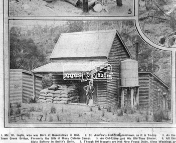
Photograph, Queenstown - St. Andrews District. "Quartz awaiting crushing at the State Battery in Smith's Gully.", c.1929
"The State Battery was the central component in the gold mining of this area from the 1920s. The battery crushed the gold bearing quartz extracted from the mines and was a sizeable weatherboard building enclosing the engine and stampers. All that now remains are the bases for the machinery that comprised the battery, one timber and a couple of concrete bases and the nearby dam, which supplied water. However the historic significance of the site remains and is enhanced by the Queenstown Cemetery on the other side of Smiths Gully Road". - Bick Study 1922 This site is now the Peter Franke Reserve and is managed by Parks Victoria Photo Source: The Leader, Nov. 2nd, 1929This photo forms part of a collection of photographs gathered by the Shire of Eltham for their centenary project book,"Pioneers and Painters: 100 years of the Shire of Eltham" by Alan Marshall (1971). The collection of over 500 images is held in partnership between Eltham District Historical Society and Yarra Plenty Regional Library (Eltham Library) and is now formally known as the 'The Shire of Eltham Pioneers Photograph Collection.' It is significant in being the first community sourced collection representing the places and people of the Shire's first one hundred years.Digital imagesepp, shire of eltham pioneers photograph collection, queenstown, st andrews, gold mining, smiths gully -
 The Beechworth Burke Museum
Geological specimen - Fossil Leaves
A fossil refers to any remains or traces of past life that are preserved in the rock. It could be remains of plants or animals. Fossil leaves are commonly found on different types of rocks. These fossils can go as far back as the Triassic Age just like the series of fossil plants collected at Denmark Hill, Ipswich in Queensland. Fossils leaves are formed when dead plants get buried by sediments like mud, sand, or volcanic ash. Often, it gets detached cleanly from stems along a special layer of weak cells, then twigs, and, less commonly, cones of conifers and fruits and seeds of flowering plants. Over time, the leaves or pieces of leaves get buried by more sediments and eventually gets 'lithified' or hardened into a rock. Erosions and mining can cause the rocks to break and reveal the fossils buried in it. Fossilisation frequently takes place at sites in the lowlands where deposits of clay, silt, sand are found. This is usually due to weathering and erosion of rocks. Fossil leaves can provide information about ancient Australia's way of living. It contributes to Victorian biodiversity records and its botanical collections. It also contributes information on the geographical profile of Victoria as fossilisation usually occur at estuaries and deltas of rivers, river flood plains, ponds and lakes. This specimen is part of a larger collection of geological and mineral specimens collected from around Australia (and some parts of the world) and donated to the Burke Museum between 1868-1880. A large percentage of these specimens were collected in Victoria as part of the Geological Survey of Victoria that begun in 1852 (in response to the Gold Rush) to study and map the geology of Victoria. Collecting geological specimens was an important part of mapping and understanding the scientific makeup of the earth. Many of these specimens were sent to research and collecting organisations across Australia, including the Burke Museum, to educate and encourage further study.Piece of light brown rock with fossilised leaves in shades of golden yellow and brown.Existing label: Fossil Leaves / Locality unknown / might be worth checking if this is Glossopteris, a Permian age plant. / C. William 16/4/21 geological specimen, geology, geology collection, burke museum, beechworth, fossil leaves, fossilization, 1868 geological survey of victoria, lithified, rocks, fossilised leaf, rock, fossils, leaves -
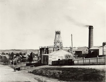 Bendigo Historical Society Inc.
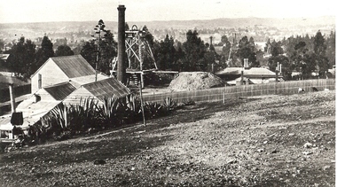
Photograph - MINE WINDER HOUSE
... Surface equipment surface site Bendigo mines and mining ...Black and white photograph. Mine winder house, poppet head, ore bins, chimney and shed. Residences adjacent to mine and streets. Poppet heads visible in far background. surface equipment, surface site, bendigo, mines and mining, mine, mining, poppet head, transport, dray, mining landscape, landscape -
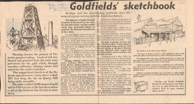 Bendigo Historical Society Inc.
Newspaper - GOLDFIELDS SKETCHBOOK ARTICLE, BENDIGO ADVERTISER, 23rd July 1970
Newspaper article titled' Goldfields' sketchbook. Article on book release ' Bendigo and Eastern Goldfields Sketchbook with Drawings by Unk White and text by John Bechervaise, first published 1970, 64 pages, hardback edition, $1.95. Extract from article ' our poppet-head sketch is of the Deborah superstructure, rising above a shaft 2017 feet deep, the site on Quarry Hill being easily accessible. The mine yielded 52,000 ounces of gold and in 1954 was one of the last three mines all on the Deborah line of reef, to close down'Bendigo Advertiser July 23rd 1970.bendigo, mining, gold discovery, 'bendigo advertiser