Showing 488 items matching "north avenue"
-
 Whitehorse Historical Society Inc.
Book - Heritage Study, City Of Whitehorse Post-1945 Heritage Study, 4 March 2015
... Peter Avenue, Blackburn North. (old house - timber pre 1945... Simmenauer is 2 Peter Avenue, Blackburn North. (old house - timber ...City of Whitehorse Post-1945 Heritage Study, dated 4 March 2015A4, 285 pages. A draft copy of the City of Whitehorse Post-1945 Heritage Study, dated 4 March 2015 (on front page) plus published copy of Appendix 2 pages 275-285non-fictionCity of Whitehorse Post-1945 Heritage Study, dated 4 March 2015 city of whitehorse, post war buildings, built heritage pty ltd, historic buildings, post war development, houses, architectural styles -
 Mt Dandenong & District Historical Society Inc.
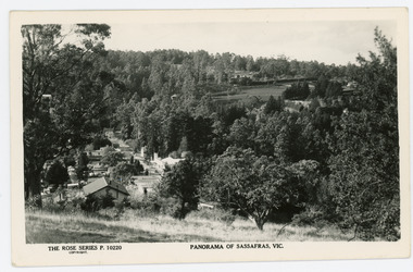
Photograph, Panorama of Sassafras, Vic, c1950
Panorama of Sassafras in the 1950s taken from Wallaby Avenue looking down onto the Sassafras Cabaret building. Rostrevor can be seen at centre top.Black and white Rose Series postcard P. 10220 showing a view from high down the Main Street of Sassafras looking north towards Olinda.On reverse POST CARD. A Real Photograph. Produced in Australia.rose series, postcard, sassafras, cabaret, wallaby avenue, rostrevor -
 Southern Sherbrooke Historical Society Inc.
Information Folder - St. Bartholomew's Anglican Church, Ferntree Gully and St. Thomas' Anglican Church, Upper Ferntree Gully
Information folder containing items pertaining to the history of St. Bartholomew's Anglican Church, Ferntree Gully and St. Thomas' Anglican Church, Upper Ferntree Gully. Contents: -letter, Bob Collie to Susan Heywood-Downard, dated 12 October 1995 -photo, Rev. W. M. Robertson -photo, "Rev. W. G. Thomas 1913-1918" -photo, "St. Bartholomew's/Ferntree Gully/Station St -Lower FTG/No longer there" -photo, aerial shot of Ferntree Gully township, "Mr Curlewis, Gacidal (?) St, North Bayswater. The clergy house is at the extreme RH of photo, on top of hill. It is no longer there on 'The Avenue'" -booklet, "The Anglican Church of St. Thomas, Upper Ferntree Gully. A Short Guide & brief history" by Brian Kennedy, June 1993 -booklet, "The Church of England, St. Bartholomew's Ferntree Gully Lower, St. Thomas', Ferntree Gully Upper. Combined Funds Canvass - 1957"st. bartholomew's anglican church, ferntree gully, st. thomas' anglican church, upper ferntree gully. -
 Southern Sherbrooke Historical Society Inc.
Photograph - Glen Park Farm, Selby
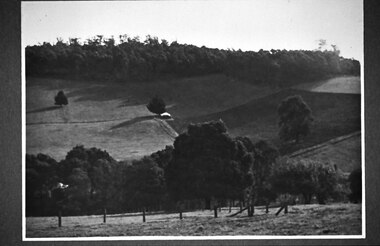
B&W photo showing Glen Park Farm, Selby, owned by the Johns family, as seen from the north-east corner. Photo shows the descent to the valley then up Black Hill in the background. Mostly cleared paddock apart from the cypress avenue to the farmhouse (which is glimpsed between the trees) a few single trees dotted about, and the heavily treed area on the top of Black Hill. There is a small building or shed or possibly a haystack in the centre of the photo. -
 Ballarat Tramway Museum
Photograph - Leaf from a photo album, 1920s
Leaf from a photo album containing 4 black and white photographs pasted onto sheet of brown/grey cardboard with two punch holes at one end. Photos taken early 1920's or just after construction of the Memorial Arch. Photo 1 - "Ballarat" handwritten in pencil at top - Town Hall from the North West taken from a building near Doveton St. Has a Sebastopol tram west bound in Sturt St. passing Town Hall. Photo 2 - "Sturt Street Ballarat" handwritten in pencil at base - Sturt St. Ballarat looking east from most likely the Ballarat City fire station lookout tower. Has a Sebastopol tram travelling eastbound in the photograph. Town Hall in background. No motor vehicles in photograph. Photo 3 - "Memorial Arch, Ballarat" handwritten in pencil at top - photo of the new Memorial Arch at the start of the Avenue of Honour. Photo 4 - "Eureka Stockade, Ballarat" - photo of the Eureka Stockade monument the park.trams, tramways, ballarat, sturt st, memorial arch - avenue of honour, eureka -
 Ballarat Tramway Museum
Postcard, Sturt St. from top of the Nicholl and Allan Building, c1904
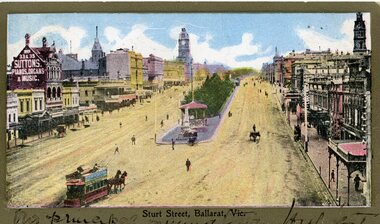
2437 - Printed colour postcard of the east end of Sturt St. from top of the Nicholl and Allan Building in Grenville St looking west. Has a horse tram leaving the Grenville St. terminus travelling up to Lydiard St. on the north side of Sturt St. Has the buildings on either side of Sturt St. in the view, including Suttons Music store. Titled "Sturt St Ballarat Vic" along the bottom edge. 2437.1 - On the bottom of the postcard is a two line hand written message. On rear of postcard is the address to a Miss C. Haurley of 4 Mortuary Road, South Shields England and two Victorian stamps - half penny (green) and one penny (red) stamps. Has been postmarked "North Melbourne Vic. Feb? 23 05" and over stamped "289" over the penny stamp. See images .1 and .2 2437.2 - On the bottom of the postcard is a single line hand written message. On the rear of postcard is the address to a Mr Frank Tucker, Glencairn, Park Avenue, Harrogate, England. Has two Victorian stamps, half penny (green) and one penny (red) stamps. Has been postmarked twice with the same stamp, "Ballarat East 16.01.04" or 16.11.04?? See images .3 and .4 See Reg Item 5103 for a black and photograph close up of the horse tram in the photo. trams, tramways, horse trams, sturt st, postcards, grenville st -
 Ballarat Tramway Museum
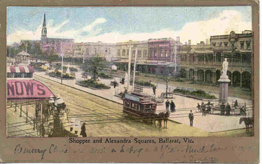
Postcard, "Shoppee and Alexandra Squares Ballarat Vic.", c1904
Printed colour postcard from top of the Town Hall, looking northwest with Snows building in the foreground looking west. Has a horse tram travelling up to Lydiard St. on the south side of Sturt St. Has the buildings on north side of Sturt St. in the view, including the central median reserve before the trees had grown. Titled "Shoppee and Alexandra Squares, Ballarat Vic." along the bottom edge. On the bottom of the postcard is a one line hand written message, ink fading, very hard to read. On rear of postcard is the address to a Mr Frank Tucker, Glencairn, Park Avenue, Harrogate, England. Has two Victorian stamps, half penny (green) and one penny (red) stamps. Has been postmarked, "Ballarat East 16.11.04". See images .1 and .2. Two copies held - on the second copy, the address details have been crossed out and the stamp removed. Yields information about central Ballarat in the horse tram days.Postcard - printed colour, divided back, used.trams, tramways, horse trams, sturt st, postcards, snows, tram 3 -
 Ballarat Tramway Museum
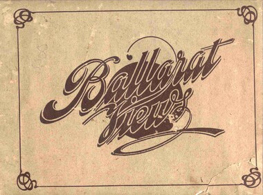
Book, Baxter & Stubbs, "Ballarat Views", 1920's
Yields information about Ballarat through pictures of the 1910-1920's various locations, institutions and street scenes, including tramways and railways.Twenty four page book within light brown covers, titled "Ballarat Views". Sheets, other than covers have been individually printed both sides, stapled within the covers. Cover - gives title, rear cover has printer details - Baxter and Stubbs. Pages 1 - Tonner Memorial , Fountain Lake Wendouree, Ballarat District Hospital, Sturt St south side at Grenville St with tram in distance and Sturt St North Side showing shops (image btm3900i2.jpg). 2 - Ballarat Street Scenes - Sturt Streets, Lydiard St with ESCo 18 in view, and Railway station with R193 in platform on passenger train. (image btm3900i3.jpg). 3 - Lake Wendouree views. 4 - Lake Wendouree, fish hatchery, Gardens and Sturt St at Dawson St (image btm3900i4.jpg). 5 - Art Gallery Ballarat 6 - Botanical Gardens 7 - Public Institution s- Benevolent asylum, Orphanage, Nazareth House, St Joseph Home, Hospital 8 & 9 - Statues, the Flight from Pompeii and others. 10 & 11 - Churches of Ballarat 12 - The Arch at The Avenue of Honour 13 - McDonald Pergola at the Gardens 14 - Zoological Gardens Ballarat 15 - Gardens aerial view and gates at the South End with tram in the distance (image btm3900i5.jpg). 16 - Some views in Ballarat East - Eureka Stockade, Ballarat East Bowling Green, Bridge St looking east and the lake at the Eureka Gardens (image btm3900i6.jpg). 17 - Snow Scene at Botanical Gardens, Begonia House 18 & 19 - Ballarat Water supply reservoirs 20 - Ballarat State Schools 21 - Ballarat East Views, includes view of track in Victoria St looking east (image btm3900i7.jpg). 22 - Views of the Water Reserves 23 - Views about the City - includes City fire station , agricultural High School, City Baths and View Point. 24 - Views at Lake Wendouree. \ Pdf copy of full book added 8/5/2019 - see btm3900i9.pdf trams, tramways, ballarat, lydiard st, sturt st, gardens, railway station, hospital, lake wendouree, wendouree parade, carlton st, esco -
 Ballarat Tramway Museum
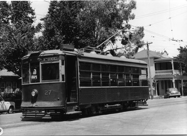
Photograph - Black & White Photograph/s, Keith Kings, 30/01/2956 12:00:00 AM
Black and White Photograph of SEC Bendigo Birney 27 in McCrae St and Arnold St, 30/1/1956. Has destination of North Bendigo, and the hotel in the background. Photo Keith Kings, number R(q)(8) Stamp in top right hand corner and handwritten number with "K.S. Kings No. R(q)(8) Copyright reserved". In black ink "Bendigo / Birney 27 in McCrae St and Arnold St, (Now Tramways Avenue) 30/1/1956. On front of photograph in bottom left hand corner, white dot with number "19"trams, tramways, bendigo, birney, mccrae st, tram 27 -
 Kew Historical Society Inc
Plan, Melbourne & Metropolitan Board of Works : Borough of Kew : Detail Plan No.1590, 1905
The Melbourne and Metropolitan Board of Works (MMBW) plans were produced from the 1890s to the 1950s. They were crucial to the design and development of Melbourne's sewerage and drainage system. The plans, at a scale of 40 feet to 1 inch (1:480), provide a detailed historical record of Melbourne streetscapes and environmental features. Each plan covers one or two street blocks (roughly six streets), showing details of buildings, including garden layouts and ownership boundaries, and features such as laneways, drains, bridges, parks, municipal boundaries and other prominent landmarks as they existed at the time each plan was produced. (Source: State Library of Victoria)This plan forms part of a large group of MMBW plans and maps that was donated to the Society by the Mr Poulter, City Engineer of the City of Kew in 1989. Within this collection, thirty-five hand-coloured plans, backed with linen, are of statewide significance as they include annotations that provide details of construction materials used in buildings in the first decade of the 20th century as well as additional information about land ownership and usage. The copies in the Public Record Office Victoria and the State Library of Victoria are monochrome versions which do not denote building materials so that the maps in this collection are invaluable and unique tools for researchers and heritage consultants. A number of the plans are not held in the collection of the State Library of Victoria so they have the additional attribute of rarity.Original survey plan, issued by the MMBW to a contractor with responsibility for constructing sewers in the area identified on the plan within the Borough of Kew. The plan was at some stage hand-coloured, possibly by the contractor, but more likely by officers working in the Engineering Department of the Borough and later Town, then City of Kew. The hand-coloured sections of buildings on the plan were used to denote masonry or brick constructions (pink), weatherboard constructions (yellow), and public buildings (grey). Surveyed by the Board of Works in 1903 and published in 1904, Plan No.1590 shows development north of Cotham Road. While this plan includes built structures in Mary Street, Cotham Road, High Street, Park Hill Road, Kent Street, Ridgeway Avenue, and Ermington Lane (now Ermington Place), only part of this section was notated and coloured in this contractor’s copy. Numerous houses, large and small are named on the plan: ‘Cholula’, ‘Belper’, ‘The Uplands’, ‘Spring Grove’ facing Cotham Road; ‘Marion’ facing Kent Street; and ‘Kia Ora’ facing Ridgeway Avenue.melbourne and metropolitan board of works, detail plans, mmbw 1590, survey plans - borough of kew, cartography -
 Kew Historical Society Inc
Plan - Subdivision Plan, H C Crouch, Old Golf Links Estate, 1930s
The land in North Kew between the Outer Circle Railway and the River Yarra was released in sections. This release included 80 lots. Most of this area was released during the Depression years in the early 1930s.Subdivision plans are historically important documents used as evidence of the growth of suburbs in Australia. They frequently provide information about when the land was sold on which a built structure was subsequently constructed as well as evidence relating to surveyors and real estate and financial agents. The numerous subdivision plans in the Kew Historical Society's collection represent working documents, ranging from the initial sketches made in planning a subdivision to printed plans on which auctioneers or agents listed the prices for which individual lots were sold. In a number of cases, the reverse of a subdivision plan in the collection includes a photograph of a house that was also for sale by the agent. These photographs provide significant heritage information relating house design and decoration, fencing and household gardens.One part of a massive subdivision of the Old Golf Links Estate in North Kew of 80 allotments bordering Sutherland Avenue, Ramsay Avenue, Belford Road, Beresford Street and Coleman Avenue. Inset on the plan at the top left, the route of the Outer Circle Railway is clearly marked. The Kew Golf Links is identified in its current location. The land on which Greenacres Golf Club was to be constructed is at this time marked as ‘Recreation Ground’. The ‘new bridge’ over the Yarra at Burke Road is also marked on the inset map. The Plan identifies the surveyor (sic) H.C. Crouch BCE MVIS, 443 Little Collins St., Melbourne. The date of the subdivision auction sale in identified as Saturday September 25th at three o'clock.Annotations: "E" top left. "Golf Links" top right. Lots 73-76 ticked and listed as "6" poundssubdivisions -- kew (vic.), old golf links estate -
 Kew Historical Society Inc
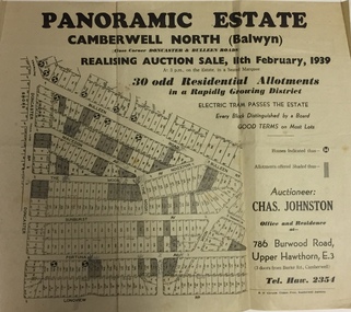
Plan - Subdivision Plan, Panoramic Estate, Camberwell North (Balwyn), 1939, 1939
Subdivision plan advertised as the Panoramic Estate, Balwyn, showing lots for sale in the following streets: Bulleen Road, Macedon Avenue, The Moor, Sunburst Avenue, Doncaster Road, Fortuna Avenue, Longview Road, The Nook, and Touring Avenue.Single page subdivision plan of the Panoramic Estate in Camberwell North (Balwyn); offered for sale in 1939Nilsubdivision plans - balwyn (vic), panoramic estate - camberwell north - balwyn (vic) -
 Kew Historical Society Inc
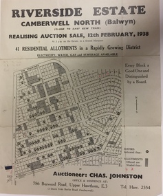
Plan - Subdivision Plan, Riverside Estate, Camberwell North (Balwyn), 1938, 1939
This subdivision known as the Riverside Estate wa sone of the largest and most significant in Balwyn's history.Subdivision Plan for 41 lots within the wider Riverside Estate in Camberwell North, now Balwyn, in February 1938. The auction featured lots in Burke Road, The Boulevard, Mt View Road, Wattle Avenue, Kyora Parade, Cascade Street, Riverside Avenue, Walbundry Avenue, Inverness Way, Bulleen Road and Doncaster Road.Allotments for sale are shaded grey on the map. Certain lots have an H in a circle. These are presumably where houses had already been constructed.subdivision plans - balwyn (vic), riverside estate - balwyn (vic) -
Kew Historical Society Inc
Journal, Kewriosity : November 1987
Home Helpers in Pilot Training Program / p1. [Woodlands Avenue] Playgroup enrolments / p1. Help wanted [Australia's Bicentennial Choir] / p1. Christmas cards / p1. Dates for November / p2. Images of Kew [Photographic competition; Australia's Bicentennial] / p2&7. Commentary / Cr Jim Tutt, Mayor of Kew [1987/88 Council Budget] / p3. Church centenary [Kew Presbyterian Church] / p3. [Community] Notices / p4. Volunteers needed [Asthma Foundation of Victoria] / p4. Kinder for three year olds [North Kew Municipal Kindergarten] / p4. Community Directory update / p4. Belford Oaks [Childcare Centre] / p4. Mayoresses' luncheon focuses on Asthma / p5. Recycling reminder / p5. Bicentennial notes / p5. Kew Community House / Judy Price p6. Help for fundraisers / p6. [Kew] Youth Resource Centre / p6. How much can a Library Bear bear? / p7. New citizens / p7. Croquet - not just a game, but an enigma [Kew Croquet Club] / p7. Keeping you informed [Citizens Advice Bureau] / p8. Good gardening / p8. Boroondara Bushwalkers / p8. Entry form for 'Images of Kew' / p8Kewriosity was a local newsletter combining Kew Council and community news. It was published between November 1983 and June 1994, replacing an earlier Kewriosity [broad] Sheet (1979-84). In producing Kewriosity, Council aimed to provide a range of interesting and informative articles covering its deliberations and decision making, together with items of general interest and importance to the Kew community and information not generally available through daily media outlets.non-fictionHome Helpers in Pilot Training Program / p1. [Woodlands Avenue] Playgroup enrolments / p1. Help wanted [Australia's Bicentennial Choir] / p1. Christmas cards / p1. Dates for November / p2. Images of Kew [Photographic competition; Australia's Bicentennial] / p2&7. Commentary / Cr Jim Tutt, Mayor of Kew [1987/88 Council Budget] / p3. Church centenary [Kew Presbyterian Church] / p3. [Community] Notices / p4. Volunteers needed [Asthma Foundation of Victoria] / p4. Kinder for three year olds [North Kew Municipal Kindergarten] / p4. Community Directory update / p4. Belford Oaks [Childcare Centre] / p4. Mayoresses' luncheon focuses on Asthma / p5. Recycling reminder / p5. Bicentennial notes / p5. Kew Community House / Judy Price p6. Help for fundraisers / p6. [Kew] Youth Resource Centre / p6. How much can a Library Bear bear? / p7. New citizens / p7. Croquet - not just a game, but an enigma [Kew Croquet Club] / p7. Keeping you informed [Citizens Advice Bureau] / p8. Good gardening / p8. Boroondara Bushwalkers / p8. Entry form for 'Images of Kew' / p8publications -- city of kew (vic.), kewriosity, council newsletters, community newsletters -
Kew Historical Society Inc
Plan - Tramway Estate, Camberwell North, 1937
Subdivision plans and real estate flyers/brochures reveal a number of aspects of urban development and history. The Kew Historical Society's collection of these plans, as well as advertisements extracted from magazines, cover key aspects of community development and architectural history of Kew and Kew Eat as well as surrounding suburbs. While most of the plans in the collection were gifted to the Society by the former City of Kew, a number of other plans and advertisements have been donated by individuals, of which this is an example.Single page subdivision plan listing properties for sale in the Tramways Estate, Camberwell North. The large estate was bounded by Doncaster Road, Burke Road, Marwan Avenue, Maud Street, Severn Street, and extended over Glass's Creek at Mayland's Avenue. Within the plan, lots 3 to 342 are listed as lots. The plan includes annotations in ink indicating the prices realised by a number of lots. A key explains that lots with an 'H' represent a house, whereas the 37 shaded lots represent those being offered by this agent. subdivision plans -- camberwell (vic.), tramways estate -
Kew Historical Society Inc
Plan - Camberwell Panorama Estate, 1923
Subdivision plans and real estate flyers/brochures reveal a number of aspects of urban development and history. The Kew Historical Society's collection of these plans, as well as advertisements extracted from magazines, cover key aspects of community development and architectural history of Kew and Kew Eat as well as surrounding suburbs. While most of the plans in the collection were gifted to the Society by the former City of Kew, a number of other plans and advertisements have been donated by individuals, of which this is an example.Promotional brochure for the Camberwell Panorama Estate. The four page bifold handout advertises 216 home sites bounded by Bulleen Road, The Nook, Fortuna Avenue, and Doncaster Road. Other streets in the subdivision include: Sunburst Avenue, The Moor, and Macedon Avenue. The brochure has been damaged at some time in the past and so masking tape obscures the tram on page 1. Page 2 includes the plan of the subdivision, page 3 information about the site and a locality plan, while page 4 includes photographs and terms of sale. subdivision plans -- balwyn north (vic.), camberwell panorama estate -
 Kew Historical Society Inc
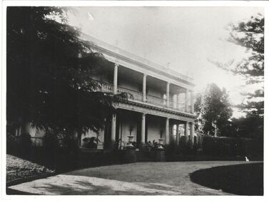
Photograph, Studley House, circa 1900, c. 1900
The first section of Studley House, now part of the preparatory school for Xavier College conducted by the Society of Jesus in Kew, Burke Hall, was built in about 1857 for Parliamentarian John Hodgson, an early settler in the district, as a two-storey residence in the Classical Revival style. The name Studley House was first recorded in the Kew ratebooks in 1862, after the housewas purchased in 1860 by James McEvoy, squattter. Alterations and an extension, designed by William J Ellis were undertaken in 1875. The house was again altered in 1919 during the ownership of John Wren, former bookmaker, ALP lobbyist, influential Irish-Catholic and millionaire. After 1969 the house was used by theschool. Studley House retains evidence of the original 1850s section, plaster and woodwork, and stained glass from its earlier period. - Source: Victorian Heritage RegisterThis work forms part of the collection assembled by the historian Dorothy Rogers, that was donated to the Kew Historical Society by her son John Rogers in 2015. The manuscripts, photographs, maps, and documents were sourced by her from both family and local collections or produced as references for her print publications. Many were directly used by Rogers in writing ‘Lovely Old Homes of Kew’ (1961) and 'A History of Kew' (1973), or the numerous articles on local history that she produced for suburban newspapers. Most of the photographs in the collection include detailed annotations in her hand. The Rogers Collection provides a comprehensive insight into the working habits of a historian in the 1960s and 1970s. Together it forms the largest privately-donated collection within the archives of the Kew Historical SocietyA photograph of the north facing facade of Studley House in Nolan Avenue before the additions made by John Wren..Studley House, Nolan Avenue. Before addition of new wing in 1915 (confirms your observations) M.K.studley house, nolan avenue, xavier preparatory school, dorothy rogers -
 Kew Historical Society Inc
Plan - Subdivision Plan, Six Big Home Sites, Camberwell North, c.1936
Subdivision plans are historically important documents used as evidence of the growth of suburbs in Australia. They frequently provide information about when the land was sold on which a built structure was subsequently constructed as well as evidence relating to surveyors and real estate and financial agents. The numerous subdivision plans in the Kew Historical Society's collection represent working documents, ranging from the initial sketches made in planning a subdivision to printed plans on which auctioneers or agents listed the prices for which individual lots were sold. In a number of cases, the reverse of a subdivision plan in the collection includes a photograph of a house that was also for sale by the agent. These photographs provide significant heritage information relating house design and decoration, fencing and household gardens.A subdivision in what is currently Balwyn, but which was advertised as being in Camberwell North. The subdivision included six allotments facing Buchanan Avenue and Houghton Street. The subdivision was to the east of the Pointed Firs Estate (1936). In addition to the intrinsic value of this subdivision plan, it also reveals information about the development of transport infrastructure in this area. The subdivision plan notes that the Tramways Board has approved the extension of the tram route past the current terminus at Balwyn Road.subdivision plans - camberwell -
 Kew Historical Society Inc
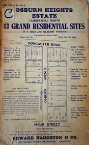
Plan - Subdivision Plan, Osburn Heights Estate, 1938
Edward Haughton & Co, in promoting the Osburn Heights Estate in what is now Balwyn North, attempted to capitalize on the subdivision’s proximity to East Kew. One section of the plan is includes the text: ‘The New Suburb: Camberwell North or East Kew (the names are synonymous)’. The Osburn Heights subdivision was part of a series of subdivisions running between Doncaster Road and Maud Street, including the ‘Pointed Firs Estate’ (MAP.0010). This subdivision included 13 ‘grand residential sites’ for sale in Doncaster Road, Maud Street and Osburn Avenue.subdivision plans - camberwell north, osburn heights estate -
 Kew Historical Society Inc
Plan, Melbourne & Metropolitan Board of Works : Borough of Kew : Detail Plan No.1350, 1910
The Melbourne and Metropolitan Board of Works (MMBW) plans were produced from the 1890s to the 1950s. They were crucial to the design and development of Melbourne's sewerage and drainage system. The plans, at a scale of 40 feet to 1 inch (1:480), provide a detailed historical record of Melbourne streetscapes and environmental features. Each plan covers one or two street blocks (roughly six streets), showing details of buildings, including garden layouts and ownership boundaries, and features such as laneways, drains, bridges, parks, municipal boundaries and other prominent landmarks as they existed at the time each plan was produced. (Source: State Library of Victoria). This plan forms part of a large group of MMBW plans and maps that was donated to the Society by the Mr Poulter, City Engineer of the City of Kew in 1989. Within this collection, thirty-five hand-coloured plans, backed with linen, are of statewide significance as they include annotations that provide details of construction materials used in buildings in the first decade of the 20th century as well as additional information about land ownership and usage. The copies in the Public Record Office Victoria and the State Library of Victoria are monochrome versions which do not denote building materials so that the maps in this collection are invaluable and unique tools for researchers and heritage consultants. A number of the plans are not held in the collection of the State Library of Victoria so they have the additional attribute of rarity.Original survey plan, issued by the MMBW to a contractor with responsibility for constructing sewers in the area identified on the plan within the Borough of Kew. The plan was at some stage hand-coloured, possibly by the contractor, but more likely by officers working in the Engineering Department of the Borough and later Town, then City of Kew. The hand-coloured sections of buildings on the plan were used to denote masonry or brick constructions (pink), weatherboard constructions (yellow), and public buildings (grey). MMBW Plan No. 1350 depicts the western end of Studley Park on the north side of the Studley Park Road. ‘Raheen’, then the home of Sir Henry Wrixon is named, the plan identifying those parts of the house that were built of brick and timber. The two houses between Raheen and the River Yarra are also shown. Other parts of the plan show neighbouring streets: Yarra Street, Studley Park Avenue, Studley Street and Fenwick Street. Each, apart from Fenwick Street was subsequently renamed. At the corner of Fenwick and Stawell Streets, the home of Joseph Butterworth Coombs, later called ‘Hope Mansell’, is represented but unnamed.melbourne and metropolitan board of works, detail plans, mmbw 1350, cartography -
 Kew Historical Society Inc
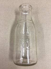
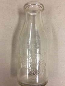
Container, Model Dairy, Milk Bottle, Twentieth Century
The Model Dairy was founded by the Kew pioneer, James Venn Morgan. The dairy had a number of different locations in Kew depending on the time period. Its final incarnation was on the north side of Cotham Road, between Ridgeway Avenue and Kent Street, Kew. The final factory was designed by the architects Bates, Smart and McCutcheon.Kew was a major milk producing district in the Nineteenth and early Twentieth centuries, with three major dairy farms lining the Yarra between Studley Park in the west and Burke Road in the east. In addition to these dairy producers, there were also a number of accredited dairy retailers in the suburb. The largest and most enduring of these was the Model Dairy founded by the Kew pioneer James Venn Morgan. Milk bottles that include the name of the producer or retailer are historically significant as they represent a period in Kew's history before the mass production of milk in the second half of the Twentieth Century. A number of these named bottles have the additional attribute of rarity.Milk bottle - Model Dairy Kew. Pressed inscription: "Model Dairy Ltd Kew." Reverse: " This bottle contains milk bottled for sale by Model Dairey Ltd and always remains their property. It is loaned & cannot legally be used by others. One Imperial Pint. This bottle differs from 1981.0010 in that it has two pressed rings on the neck of the bottle.milk bottles, model dairy (kew) -
 Kew Historical Society Inc
Container, Model Dairy, Milk Bottle, Twentieth Century
The Model Dairy was founded by the Kew pioneer, James Venn Morgan. The dairy had a number of different locations in Kew depending on the time period. Its final location was on the north side of Cotham Road, Kew between Ridgeway Avenue and Kent Street. Its final factory was designed by the architects Bates, Smart and McCutcheon.Kew was a major milk producing district in the Nineteenth and early Twentieth centuries, with three major dairy farms lining the Yarra between Studley Park in the west and Burke Road in the east. In addition to these dairy producers, there were also a number of accredited dairy retailers in the suburb. The largest and most enduring of these was the Model Dairy founded by the Kew pioneer James Venn Morgan. Milk bottles that include the name of the producer or retailer are historically significant as they represent a period in Kew's history before the mass production of milk in the second half of the Twentieth Century. A number of these named bottles have the additional attribute of rarity.Milk bottle - Model Dairy Kew. Pressed inscription: "Model Dairy Ltd Kew." Reverse: " This bottle contains milk bottled for sale by Model Dairey Ltd and always remains their property. It is loaned & cannot legally be used by others. One Imperial Pint. This bottle differs from 1981.0009 in that it does not have two pressed rings on the neck of the bottle.milk bottles, model dairy (kew) -
 Kew Historical Society Inc
Photograph, Floods in North Kew, 1971
Living with natural processes was frequently a challenge to early European settlers and later residents of what was in the 1850s administered by the Borondara Road Board. This was compounded by the area being bounded on three sides by rivers (Yarra River, Koonung Creek and Gardiner's Creek). In 1849, the historian James Bonwick recorded that "our district [Kew] suffered considerably. Mr Wade speaks of 80 acres, out of 100 acres of his cultivated paddock, covered by water." Newspapers continued to describe major flooding in Kew in 1863, 1869, 1878, 1880, 1889, 1891, 1916 and 1934. While the construction of the Upper Yarra dam in 1957 reduced the levels of flowing downstream, local and riverine floods continue.The Kew Historical Society's pictures and map collections testify to the impact of flooding in the district. They have historical importance in documenting the extent of flooding in the district and its affects on homes, services and recreation. Numerous photographs record flooding throughout the Twentieth Century.Floods in North Kew, 1971. Looking northeast towards Kilby Road from River Avenue. Annotation on reverse: map and date "8 Nov. 71 10.30am".floods (kew), yarra river, kew flood, kilby road flood -
 Kew Historical Society Inc
Map, MMBW, MMBW Plan No.65 Kew & Heidelberg, 1900-1910
The Melbourne and Metropolitan Board of Works (MMBW) was established by an act of the Victorian Parliament in 1890 to prepare for and to implement a sewerage and water reticulation system across what was then inner Melbourne, its surrounding and middle distance suburbs, including Kew. The MMBW was disbanded in 1991.The map collection of the Kew Historical Society has at its core the historic maps assembled and originally stored in the City Engineer's Department of the City of Kew. These include maps in a number of scales. The vast majority of maps were produced by the MMBW in the first two decades of the twentieth century, and are solid working maps, backed by linen for durability. These maps are historically significant to Kew, the City of Boroondara and to the history of the development of state utilities in Victoria. A number of the Kew maps have additional details added by former municipal officers, including the levels reached by various floods. As these were working documents, information was added to them long after the period of their initial production and distribution.Early map of part of the Borough of Kew, created in the first decade of the twentieth century, at a scale 160 ft to 1 inch. The map covers what was then the south central part of Kew, bordered on its north by Malmsbury Street, in the west by Florence Avenue, in the south by Barkers Road, and in the east by Princess Street. The map shows the extent of urban development by that time, prominent institutions and the outlines of built structures in the municipality. Contour lines were added in ink to the map at a later stage.MELBOURNE AND METROPOLITAN BOARD OF WORKS / PLAN NO. 65 / KEW & HEIDELBERGmelbourne & metropolitan board of works, mmbw maps, mmbw plans, borough of kew, cartography -
 Kew Historical Society Inc
Map, MMBW, MMBW Plan No.67 Kew, 1900-1910
The Melbourne and Metropolitan Board of Works (MMBW) was established by an act of the Victorian Parliament in 1890 to prepare for and to implement a sewerage and water reticulation system across what was then inner Melbourne, its surrounding and middle distance suburbs, including Kew. The MMBW was disbanded in 1991.The map collection of the Kew Historical Society has at its core the historic maps assembled and originally stored in the City Engineer's Department of the City of Kew. These include maps in a number of scales. The vast majority of maps were produced by the MMBW in the first two decades of the twentieth century, and are solid working maps, backed by linen for durability. These maps are historically significant to Kew, the City of Boroondara and to the history of the development of state utilities in Victoria. A number of the Kew maps have additional details added by former municipal officers, including the levels reached by various floods. As these were working documents, information was added to them long after the period of their initial production and distribution.Early map of part of the Borough of Kew, created in the first decade of the twentieth century, at a scale 160 ft to 1 inch. The map covers what was then the north central part of Kew, bordered on its north by the Outer Circle Railway Spruzen and Beresford Avenues, in the west by Princess Street, in the south by High Street, and in the east by (about) Belford Road. The map shows the extent of urban development by that time, prominent institutions and the outlines of built structures in the municipality. Contour lines were added in ink to the map at a later stage.MELBOURNE AND METROPOLITAN BOARD OF WORKS / PLAN NO. 67 / KEW melbourne & metropolitan board of works, mmbw maps, mmbw plans, borough of kew, cartography -
 Glen Eira City Council History and Heritage Collection
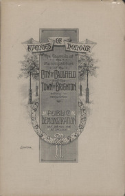
Booklet, "AVENUES OF HONOUR The Councils of the Municipalities of the CITY OF CAULFIELD TOWN OF BRIGHTON acting in conjunction PUBLIC DEMONSTRATION SAT 3rd AUG. 1918 AT 3oCLOCK"
Souvenir Programme from the Councils of the Municipalities of the City of Caulfield and the Town of Brighton for a Public Demonstration to be held on Sat 3rd August 1918 at 3 o'clock for the proposed Avenues of Honour to be planted in memory of fallen WWI soldiers. From Honour Roll Display 2019 interpretation panel - Brighton-Caulfield Avenue of Honour It is hard to imagine but a grand arboreal Avenue of Honour once lined parts of North Road, McMillan Street and Point Nepean Road (now Nepean Highway). The Avenue of Honour was a distinctly Australian phenomenon with hundreds being constructed throughout Australia during and following World War One, most of these in Victoria. Consisting of tree lined streets with each tree representing a solider, the Avenue of Honour signalled a more egalitarian approach to commemoration where rank was not a consideration. Arguably the most famous Avenue of Honour in Victoria still exists at Ballarat. Stretching for nearly 22 kilometres, the entrance to the Avenue is marked by the imposing Arch of Victory. Smaller in scale, the Brighton-Caulfield Avenue of Honour was dedicated to the ‘memory of (Brighton and Caulfield’s) kith and kin who came from (the) district and who died in the Great War’. A joint project between the neighbouring Councils, the idea was first reported in The Argus on 1 July 1918. Plans moved along quickly and on 3 August 1918 the Governor of Victoria Arthur Stanley planted the first Australian flowering gum. The next of kin were then invited to plant trees for lost sons, brothers, uncles, nephews and husbands. In all, over 400 trees were planted. Intensely personal, the Avenue also acted as a focus of grief and remembrance for the wider community. For many years, the annual civic Anzac Day service was held at the Avenue on Point Nepean Road, near Glen Huntly Road, Elsternwick. The service was moved to Caulfield Park upon the completion of the Cenotaph in 1930. Due to road widening and disease the last original tree was replaced in the 1980s, however a plaque in Caulfield Park records the Avenue’s plantation. Commemorative booklet, grey cover with text printed on the grey textured paper cover and an image of four trees and a wreath. Image of a kookaburra on the back. Inside, 28 numbered pages with b/w text and photographic images including a transparent paper representation of the proposed Avenues of Honour on Brighton Road and Point Nepean Road. Souvenir programme for a Public Demonstration for the Avenues of Honour as detailed on the front.city of caufield, world war one, first world war, anzac, remembrance, town of brighton, brighton, caulfield, avenue of honour -
 Glen Eira City Council History and Heritage Collection
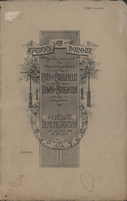
Booklet, D. W. Paterson Co. Pty. Ltd, "AVENUES OF HONOUR The Councils of the Municipalities of the CITY OF CAULFIELD TOWN OF BRIGHTON acting in conjunction PUBLIC DEMONSTRATION SAT 3rd AUG. 1918 AT 3oCLOCK SOUVENIR"
Souvenir Programme from the Councils of the Municipalities of the City of Caulfield and the Town of Brighton for a Public Demonstration to be held on Sat 3rd August 1918 at 3 o'clock for the proposed Avenues of Honour to be planted in memory of fallen WWI soldiers. One of two known copies, this copy has "Town Clerk" stamped in the upper corner, rhs.Commemorative booklet, grey cover with text printed on the grey textured paper and an image of four trees and a wreath. Image of a kookaburra on the back. Inside, 28 numbered pages with b/w text and photographic images including a transparent paper representation of the proposed Avenues of Honour on Brighton Road and Point Nepean Road. Souvenir programme for a Public Demonstration for the Avenues of Honour as detailed on the front. From Honour Roll Display 2019 interpretation panel - Brighton-Caulfield Avenue of Honour It is hard to imagine but a grand arboreal Avenue of Honour once lined parts of North Road, McMillan Street and Point Nepean Road (now Nepean Highway). The Avenue of Honour was a distinctly Australian phenomenon with hundreds being constructed throughout Australia during and following World War One, most of these in Victoria. Consisting of tree lined streets with each tree representing a solider, the Avenue of Honour signalled a more egalitarian approach to commemoration where rank was not a consideration. Arguably the most famous Avenue of Honour in Victoria still exists at Ballarat. Stretching for nearly 22 kilometres, the entrance to the Avenue is marked by the imposing Arch of Victory. Smaller in scale, the Brighton-Caulfield Avenue of Honour was dedicated to the ‘memory of (Brighton and Caulfield’s) kith and kin who came from (the) district and who died in the Great War’. A joint project between the neighbouring Councils, the idea was first reported in The Argus on 1 July 1918. Plans moved along quickly and on 3 August 1918 the Governor of Victoria Arthur Stanley planted the first Australian flowering gum. The next of kin were then invited to plant trees for lost sons, brothers, uncles, nephews and husbands. In all, over 400 trees were planted. Intensely personal, the Avenue also acted as a focus of grief and remembrance for the wider community. For many years, the annual civic Anzac Day service was held at the Avenue on Point Nepean Road, near Glen Huntly Road, Elsternwick. The service was moved to Caulfield Park upon the completion of the Cenotaph in 1930. Due to road widening and disease the last original tree was replaced in the 1980s, however a plaque in Caulfield Park records the Avenue’s plantation. Inkstamp upper corner rhs: "TOWN CLERK" -
 Surrey Hills Historical Society Collection
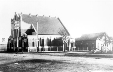
Photograph, Surrey Hills Methodist Church in 1918, 1918
The original Methodist (Wesleyan) Church was built on the corner of Alexandra Crescent and Windsor Lane in 1888. It was enlarged in 1892. In 1908 this building was removed to Valonia Avenue by horse-drawn dray. The brick church was built in 1915 after which the earlier building became the Sunday School. In 1977 the Methodist Church joined with others to become the Uniting Church. In more recent times, the brick church has been painted but architectural details visible in this photo can still be discerned.Black and white photo of a brick and rendered building taken from diagonally opposite across Canterbury Road looking to the north-west. The church sits behind a woven-wire fence with an opening at the front and at the side to a portico off Valonia Street. On the RHS is the church hall and on the LHS a small part of the adjacent house can be seen.surrey hills methodist (wesleyan) church, surrey hills uniting church -
 Surrey Hills Historical Society Collection
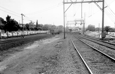
Photograph, Surrey Hills Station and car park
There are 3 tracks; the third track was built in 1971, which gives an approximate date for the photo. At this time the original station buildings were demolished and replaced by buildings constructed from concrete bricks and a second subway replaced the overhead footbridge. According to Roderick Smith, a local railway enthusiast, originally there had been 3 railway houses at the Mont Albert end of the northern car park. These were demolished to extend the car park. Certainly 8 Bedford Avenue, built as the station master's house was demolished at this time. The palm tree had been planted in the station master's front garden and was retained in a small garden bed within the car park. A black and white photograph of a station with cars parked on both sides of the 3 tracks. A Harris train is departing the station heading towards Mont Albert. A palm tree is prominent in the station car park to the north.1971, surrey hills station, railway stations, car parks, public transport, trains, railway lines, palm tree -
 Brighton Historical Society
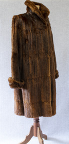
Clothing - Coat, Water rat fur coat, c.1930s
This coat belonged to Brighton resident Audrey Winifred Pickett (nee Heriot; 1915-2011). The coat is made from the pelts of rakali, also known as the Australian water rat, a native rodent species similar to an otter. Growing up to 35 centimetres in length, rakali typically live in burrows near water, feeding on fish, insects, yabbies and waterbirds. Throughout the early twentieth century, they were widely considered to be a nuisance and were hunted for their soft and waterproof fur. Demand for rakali pelts increased during the 1930s Depression years, when a ban was placed on the import of overseas furs; rakali fur became a popular substitute for the fur of the American muskrat. The species was placed under a protection order in 1938, although periodic culls were allowed until 1957 due to their perceived destruction of irrigation banks and fishing nets. Audrey recalled that the coat was made for her by furrier F. J. Ellemor after a large cull of rakali. The coat was displayed in the window of Ellemor's Block Place store. F. J. Ellemor Pty Ltd was established in 1908 by furrier Francis John Ellemor (1867-1944) and continued into the late twentieth century under the management of his son Wilfred (1801-1972). Francis and his wife Edith lived in Rothesay Avenue, Brighton from the late 1930s.Three-quarter length brown fur coat made of Australian water-rat (rakali) pelts. Wide raised collar and cuffs. Fastens centre front with two large hooks and eyes. Lined with chocolate brown silk satin.Label, woven brown on beige silk, centre back neck: created by / F. J. Ellemor / FURRIERS / MELBOURNEfur coat, rakali, australian water rat, melbourne fashion, audrey winifred heriot, audrey winifred pickett, audrey winifred north, francis john ellemor, f. j. ellemor, furrier