Showing 841 items matching "parish plan"
-
 Bacchus Marsh & District Historical Society
Map, Blackwood Parish Map, County of Bourke, 1892
... Blackwood Parish Plan...Bacchus Marsh Region Parish Plans Blackwood Parish Plan ...A single page paper map showing the map for the Parish of Blackwood in the County of Bourke. A cadastral map showing parish boundaries and land ownership. The map is pasted into a bound volume containing 76 maps or plans in total. High resolution digital image stored on BMDHS computer network. Photo-lithographed at the Department of Lands and Survey, Melbourne by T.F. McGauran 14.7.92bacchus marsh region parish plans, blackwood parish plan, blackwood parish maps -
 Bacchus Marsh & District Historical Society
Map, Blackwood Parish Map, County of Bourke, 1905
... Blackwood Parish Plan...Bacchus Marsh Region Parish Plans Blackwood Parish Plan ...A single page paper map showing the map for the Parish of Blackwood in the County of Bourke. A cadastral map showing parish boundaries and land ownership. The map is pasted into a bound volume containing 76 maps or plans in total. High resolution digital image stored on BMDHS computer network. Photo-lithographed at the Department of Lands and Survey, Melbourne by T.F. McGauran 21.7.05bacchus marsh region parish plans, blackwood parish plan, blackwood parish maps -
 Bacchus Marsh & District Historical Society
Map, Myrniong Parish Map, County of Bourke, 1882
... Myrniong Parish Plan...Myrniong Parish Plan Myrniong Parish Maps Bacchus Marsh ...A single page paper map showing the map for the Parish of Myrniong in the County of Bourke. A cadastral map showing parish boundaries and land ownership. The map is pasted into a bound volume containing 76 maps or plans in total. High resolution digital image stored on BMDHS computer network. Photo-lithographed at the Department of Lands and Survey, Melbourne by J. Noone, 17.7.82myrniong parish plan, myrniong parish maps, bacchus marsh region parish plans -
 Bendigo Historical Society Inc.
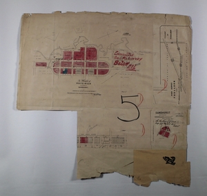
Map - SANDHURST, SHEET ?, Date missing
... parish plan...MAP Bendigo parish plan Sandhurst Map: Sandhurst (sheet ...Map: Sandhurst (sheet No., Missing) P_arish planmap, bendigo, parish plan, sandhurst -
 Bendigo Historical Society Inc.
Map - SANDHURST (PART), Circa 1900
... parish plan...MAP Bendigo parish plan Sandhurst Map: Sandhurst ( part ...Map: Sandhurst ( part), sheet No., Missingmap, bendigo, parish plan, sandhurst -
 Bacchus Marsh & District Historical Society
Map, Mooradoranook Parish Map, County of Grant
... Mooradoranook Parish Plan...Mooradoranook Parish Maps Mooradoranook Parish Plan Bacchus ...A single page paper map showing the map for the Parish of Mooradanook in the County of Grant. Cadastral map showing land ownership. The map is pasted into a bound volume containing 76 maps or plans in total. High resolution digital image stored on BMDHS computer network. Photo lithographed at the Department of Lands and Survey Melbourne by T. F. McGauran, 27.11.06mooradoranook parish maps, mooradoranook parish plan, bacchus marsh region parish plans -
 Bacchus Marsh & District Historical Society
Map, Mouyong Parish Map, County of Grant
... Mouyong Parish Plan...Mouyong Parish Plan Mouyong Parish Maps Bacchus Marsh ...A single page paper map showing the map for the Parish of Mouyong in the County of Grant. Cadastral map showing land ownership. The map is pasted into a bound volume containing 76 maps or plans in total. High resolution digital image stored on BMDHS computer network. Photo lithographed at the Department of Lands and Survey Melbourne by T. F. McGauran, 9. 4. 07mouyong parish plan, mouyong parish maps, bacchus marsh region parish plans -
 Bendigo Historical Society Inc.
Map - MANDURANG, No date visible
... parish plan...MAP Bendigo parish plan Mandurang Laanecoorie Map: It has ...Map: It has the Village of Mandurang on one side and the Township of Laanecoorie on the reversemap, bendigo, parish plan, mandurang, laanecoorie -
 Bendigo Historical Society Inc.
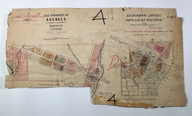
Map - LOCAL AREA PLANS, See above
... parish plan...MAP Bendigo parish plan Bridgewater Colbinnabbin Axedale ...Map: Compilation of maps: Town lots Bridgewater dated April 29 1871. Village of Colbinnabbin, dated 5 December 1866, Township of Axedale 1858 (Larritt). Suburban lands Axedale dated April 12 1871map, bendigo, parish plan, bridgewater, colbinnabbin, axedale, suburban lands -
 Bendigo Historical Society Inc.
Map - LOCAL AREA PLANS, See above
... parish plan...MAP parish plan Redcastle Yarraberb White Hills Toolleen ...Map: Compilation of maps: Village of Redcastle dated april 14 1861, Township of Yarraberb dated 14 July 1874, Hamlet of White Hills dated December 27 1872, Road survey of Toolleenmap, parish plan, redcastle, yarraberb, white hills, toolleen -
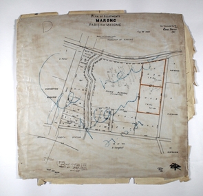 Bendigo Historical Society Inc.
Map - MARONG ALLOTMENTS, 25/08/1906
... parish plan...MAP Bendigo parish plan Marong Parish of Marong Map: Plan ...Map: Plan of Allotments at Marong, Parish of Marong, County of Bendigo. Hand draughted mapmap, bendigo, parish plan, marong, parish of marong -
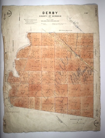 Bendigo Historical Society Inc.
Map - DERBY, 12/05/1892
... parish plan...MAP Bendigo parish plan Derby Map: Derby, County of Bendigo ...Map: Derby, County of Bendigo. Paris planmap, bendigo, parish plan, derby -
 Bendigo Historical Society Inc.
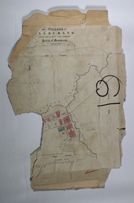
Map - JACK FLYNN COLLECTION: VILLAGE OF BETLEY, 30/06/1874
... of Dunolly. Parish plan....: Village of Betley, on the Bet Bet Creek, Parish of Dunolly. Parish ...Map: Village of Betley, on the Bet Bet Creek, Parish of Dunolly. Parish plan.Photo Lithographed at the Department of Lands and Survey Melbourne by J. Noone 30.6.74map, gladstone, village, betley, bet bet creek, dunolly -
 Bendigo Historical Society Inc.
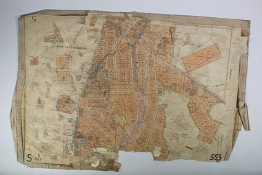
Map - SANDHURST SHEET 3, No date visible
... Map: Sandhurst sheet 3. Parish plan ( number 199 in Map... Bendigo city streets Sandhurst Map: Sandhurst sheet 3. Parish plan ...Map: Sandhurst sheet 3. Parish plan ( number 199 in Map Cupboard 1)map, bendigo, city streets, sandhurst -
Bendigo Historical Society Inc.
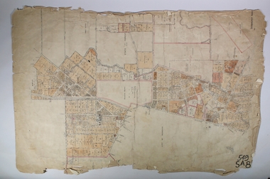
Map - SANDHURST SHEET 4, January 1947
... Map: Sandhurst sheet 4. Parish plan ( number 198 in Map... Bendigo city streets Sandhurst Map: Sandhurst sheet 4. Parish plan ...Map: Sandhurst sheet 4. Parish plan ( number 198 in Map Cupboard 1)map, bendigo, city streets, sandhurst -
Bendigo Historical Society Inc.
Map - SANDHURST SHEET 5, Circa 1940's
... Map: Sandhurst sheet 5. Parish plan ( number 197 in Map... Bendigo city streets Sandhurst Map: Sandhurst sheet 5. Parish plan ...Map: Sandhurst sheet 5. Parish plan ( number 197 in Map Cupboard 1)map, bendigo, city streets, sandhurst -
Bendigo Historical Society Inc.
Map - SANDHURST SHEET 6, 1947
... Map: Sandhurst sheet 6. Parish plan ( number 196 in Map... Bendigo city streets Sandhurst Map: Sandhurst sheet 6. Parish plan ...Map: Sandhurst sheet 6. Parish plan ( number 196 in Map Cupboard 1)map, bendigo, city streets, sandhurst -
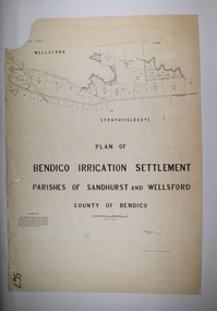 Bendigo Historical Society Inc.
Map - BENDIGO IRRIGATION SETTLEMENT, 20/10/1908
... and Wellsford, County of Bendigo, Parish plan... and Wellsford, County of Bendigo, Parish plan Map BENDIGO IRRIGATION ...Map: Bendigo Irrigation Settlement, Parishes of Sandhurst and Wellsford, County of Bendigo, Parish planmap, bendigo, irrigation settlement, bendigo irrigation settlement -
 Bendigo Historical Society Inc.
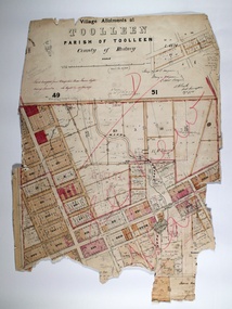
Map - TOOLLEEN ALLOTMENTS, circa 1870
... Map: Parish plan showing Village allotments at Toolleen...: Parish plan showing Village allotments at Toolleen, Parish ...Map: Parish plan showing Village allotments at Toolleen, Parish of Toolleen, County of Rodneymap, rodney, toolleen, parish of toolleen, county of rodney -
 Bendigo Historical Society Inc.
Map - JACK FLYNN COLLECTION: GIRGARRE, 14/10/1943
... Map: Parish of Girgarre , County of Rodney. Parish plan... , County of Rodney. Parish plan. Same map as 10100.20 but in poorer ...Map: Parish of Girgarre , County of Rodney. Parish plan. Same map as 10100.20 but in poorer condition.By Authority, H.E.Daw, Government printer Melbourne. Drawn and Reproduced at the Dept, of Lands and Survey, Melbourne, Victoriamap, rodney, girgarre, girgarre, county of rodney -
Bendigo Historical Society Inc.
Map - HUNTLY, 9th June 1880
... Map:Huntly, County of Bendigo. Parish plan Canvas backed... of Bendigo. Parish plan Canvas backed. ( number 138 in Map Cupboard 1 ...Map:Huntly, County of Bendigo. Parish plan Canvas backed. ( number 138 in Map Cupboard 1)map, bendigo, city streets, huntly, county of bendigo -
Bendigo Historical Society Inc.
Map - HARCOURT, 2/04/1917
... Map: Town of Harcourt, County of Talbot. Parish plan.... Parish plan (number 264 in map cupboard 1) Map HARCOURT ...Map: Town of Harcourt, County of Talbot. Parish plan (number 264 in map cupboard 1)map, talbot, township, harcourt -
Bendigo Historical Society Inc.
Map - TOWNSHIP OF HEATHCOTE SHEET 2, Circa 1935
... Map: Township of Heathcote sheet 2. Parish plan (number.... Parish plan (number 254 in map cupboard 1) Map TOWNSHIP ...Map: Township of Heathcote sheet 2. Parish plan (number 254 in map cupboard 1)map, dalhousie, township, heathcote -
Bendigo Historical Society Inc.
Map - HUNTLY ALLOTMENTS, No date visible
... Map; Huntly Allotments, County of Bendigo. Parish plan..., County of Bendigo. Parish plan (number 289 in map cupboard 1) Map ...Map; Huntly Allotments, County of Bendigo. Parish plan (number 289 in map cupboard 1)map, bendigo, allotments, huntly allotments -
 Bendigo Historical Society Inc.
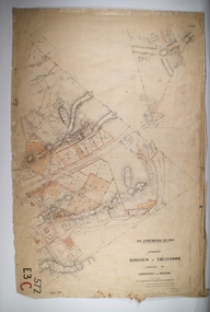
Map - BOROUGH OF EAGLEHAWK RE-SURVEY, 6/06/1883
... and Sandhurst, Sheet No. 1. Parish plan... and Sandhurst, Sheet No. 1. Parish plan Map BOROUGH OF EAGLEHAWK RE ...Map: Re-survey, Borough of Eaglhawk, Parishes of Nerring and Sandhurst, Sheet No. 1. Parish planmap, bendigo, re-survey, borough of eaglehawk, re-survey -
 Bendigo Historical Society Inc.
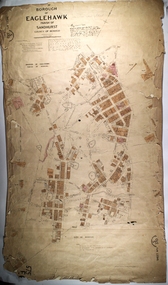
Map - PART OF THE BOROUGH OF EAGLEHAWK, 9/12/1902
... , County of Bendigo. Parish plan Canvas backed...., Parish of Sandhurst, County of Bendigo. Parish plan Canvas backed ...Map: Part of the Borough of Eaglehawk, Parish of Sandhurst, County of Bendigo. Parish plan Canvas backed.map, bendigo, city streets, borough of eaglehawk, parish of sandhurst, county of bendigo -
Bendigo Historical Society Inc.
Map - SANDHURST SHEET 1, No date visible
... Map: Sandhurst ,County of Bendigo sheet 1. Parish plan... sheet 1. Parish plan ( number 201 in Map Cupboard 1) Map ...Map: Sandhurst ,County of Bendigo sheet 1. Parish plan ( number 201 in Map Cupboard 1)map, bendigo, city streets, sandhurst -
Bendigo Historical Society Inc.
Map - SANDHURST SHEET 2, No date visible
... Map:Sandhurst, County of Bendigo Sheet 2. Parish plan... Sheet 2. Parish plan, Eaglehawk. ( number 200 in Map Cupboard 1 ...Map:Sandhurst, County of Bendigo Sheet 2. Parish plan, Eaglehawk. ( number 200 in Map Cupboard 1)map, bendigo, city streets, sandhurst -
Bendigo Historical Society Inc.
Map - LANDS AVAILABLE FOR SELECTION, 6/05/1912
... . Parish plan ( number 192 in Map Cupboard 1)... of Bendigo. Parish plan ( number 192 in Map Cupboard 1) Map LANDS ...Map: Lands available for selection, County of Bendigo. Parish plan ( number 192 in Map Cupboard 1)map, bendigo, lands available for selection, lands available for selection, bendigo -
Bendigo Historical Society Inc.
Map - KAMAROOKA ALLOTMENTS, 7/06/1894
... . Parish plan (number 288 in map cupboard 1)... Allotments, County of Bendigo. Parish plan (number 288 in map ...Map: Parish of Kamarooka Allotments, County of Bendigo. Parish plan (number 288 in map cupboard 1)map, bendigo, allotments, kamarooka, allotments