Showing 2028 items matching "planning document"
-
 Eltham District Historical Society Inc
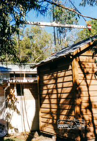
Photograph, Preparing the old Lock-up No. 17 for relocation from Youth Road to the Local History Centre at 728 Main Road, Eltham, March 2001, March 2001
The portable lock up at Eltham is not original to the site. The date of construction is unknown. It is a pre-fabricated design and each of the timber panels are individually numbered on the inside surfaces. It is amongst a large group of portable locks up,categorised as 'Portable Lock Up - Timber - Later' and also known as the "Casterton style", based on the only known plan for portable lock ups, built for the Casterton Police Station, in 1907. The later portables have been in use since the 1880s. It is not known how many lock ups of this type have been constructed in Victoria. At least 50 examples have been documented around the state. Of these, 42 are known to be extant.This lockup used to be located at the Police Station in Pryor Street and was then stored in Youth Road before being acquired for the Local History Centre 9 colour photographseltham, main road, police residence, local history centre, eltham district historical society, courthouse, youth road -
 Eltham District Historical Society Inc
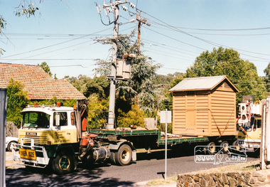
Photograph, Lock-up No. 17 arriving at the Local History Centre, 728 Main Road, Eltham, March 2001, March 2001
The portable lockup at Eltham is not original to the site. The date of construction is unknown, believed from the 1880s. It is a prefabricated design and each of the timber panels are individually numbered on the inside surfaces. It is amongst a large group of portable lockups, categorised as 'Portable Lock Up - Timber - Later' and also known as the "Casterton style", based on the only known plan for portable lock ups, built for the Casterton Police Station, in 1907. The later portables have been in use since the 1880s. It is not known how many lock ups of this type have been constructed in Victoria. At least 50 examples have been documented around the state. Of these, 42 are known to be extant. The original 1860s site lockup was a 2-cell bluestone construction. Some of the original bluestone remains. It was used in the 1970s as traffic island edging at the intersection of Main Road and Wattletree Road where it was painted white then later relocated back to this site in the 1980s to be used as edging for a driveway access off Main Road beside the former Police Residence where the Police Station originally stood. Evidence of some of this edging remains in place today leading to the replica Police Station. Other blocks were used to define the garden edging in the carpark at the rear of the residence.This lockup used to be located at the Police Station in Pryor Street and was then stored in Youth Road before being acquired for the Local History Centre 3 colour photographseltham, main road, police residence, local history centre, eltham district historical society, courthouse, youth road -
 Eltham District Historical Society Inc
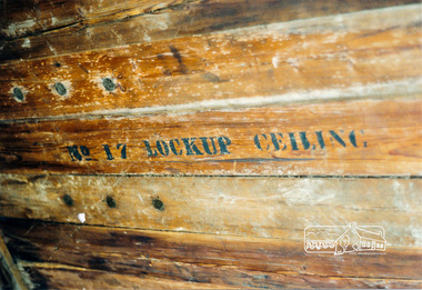
Photograph, Inside panels of No. 17 Lock-up, March 2001, March 2001
The portable lock up at Eltham is not original to the site. The date of construction is unknown. It is a pre-fabricated design and each of the timber panels are individually numbered on the inside surfaces. It is amongst a large group of portable locks up,categorised as 'Portable Lock Up - Timber - Later' and also known as the "Casterton style", based on the only known plan for portable lock ups, built for the Casterton Police Station, in 1907. The later portables have been in use since the 1880s. It is not known how many lock ups of this type have been constructed in Victoria. At least 50 examples have been documented around the state. Of these, 42 are known to be extant.This lockup used to be located at the Police Station in Pryor Street and was then stored in Youth Road before being acquired for the Local History Centre 2 colour photographseltham, main road, police residence, local history centre, eltham district historical society, courthouse, youth road -
 Eltham District Historical Society Inc
Photograph, Liz Pidgeon, Heritage Excursion; The 1901 Eltham Railway Walk, 3 May 2014, 3 May 2014
Newsletter No. 216, May 2014 May Excursion – The 1901 Eltham Railway Walk The railway from Heidelberg to Eltham was opened in 1902. Over the previous year railway construction cut a curving swathe through Josiah Holloway’s 1851 Little Eltham subdivision. The survey plans for the railway show the owners and occupiers of land within Little Eltham affected by the railway alignment and for some distance each side. The plans show houses and other buildings but development at that time was rather sparse. Copies of these plans from the State Library of Victoria collection have been provided to the Society by Alan Sheehan. For our walk on 3rd May we intend to follow the railway from the Eltham Station to Ryans Road, which was the boundary of the adjoining Montmorency Farm. The return will be by way of nearby streets. Along the way we will discuss the details shown on the railway plans as well as more recent railway documents and photographs. At the conclusion and if time permits we can inspect the historical display at the Eltham Station. The walk is about 3 km in length and will take about 2.5 hours. It will start at 2 pm at the Eltham Railway Station car park (east/Main Road side) (Melway Ref. 21 J5).Born Digitalheritage excursion, activities, eltham district historical society, eltham railway station, eltham library, trestle bridge -
 Eltham District Historical Society Inc
Photograph, Liz Pidgeon, Heritage Excursion; The 1901 Eltham Railway Walk, 3 May 2014, 3 May 2014
Football match at Eltham Central Park between Eltham and Heidelberg Newsletter No. 216, May 2014 May Excursion – The 1901 Eltham Railway Walk The railway from Heidelberg to Eltham was opened in 1902. Over the previous year railway construction cut a curving swathe through Josiah Holloway’s 1851 Little Eltham subdivision. The survey plans for the railway show the owners and occupiers of land within Little Eltham affected by the railway alignment and for some distance each side. The plans show houses and other buildings but development at that time was rather sparse. Copies of these plans from the State Library of Victoria collection have been provided to the Society by Alan Sheehan. For our walk on 3rd May we intend to follow the railway from the Eltham Station to Ryans Road, which was the boundary of the adjoining Montmorency Farm. The return will be by way of nearby streets. Along the way we will discuss the details shown on the railway plans as well as more recent railway documents and photographs. At the conclusion and if time permits we can inspect the historical display at the Eltham Station. The walk is about 3 km in length and will take about 2.5 hours. It will start at 2 pm at the Eltham Railway Station car park (east/Main Road side) (Melway Ref. 21 J5).Born Digitalheritage excursion, activities, eltham district historical society, eltham railway station, eltham library, trestle bridge, eltham central park, football -
 Eltham District Historical Society Inc
Photograph, Liz Pidgeon, Heritage Excursion; The 1901 Eltham Railway Walk, 3 May 2014, 3 May 2014
Newsletter No. 216, May 2014 May Excursion – The 1901 Eltham Railway Walk The railway from Heidelberg to Eltham was opened in 1902. Over the previous year railway construction cut a curving swathe through Josiah Holloway’s 1851 Little Eltham subdivision. The survey plans for the railway show the owners and occupiers of land within Little Eltham affected by the railway alignment and for some distance each side. The plans show houses and other buildings but development at that time was rather sparse. Copies of these plans from the State Library of Victoria collection have been provided to the Society by Alan Sheehan. For our walk on 3rd May we intend to follow the railway from the Eltham Station to Ryans Road, which was the boundary of the adjoining Montmorency Farm. The return will be by way of nearby streets. Along the way we will discuss the details shown on the railway plans as well as more recent railway documents and photographs. At the conclusion and if time permits we can inspect the historical display at the Eltham Station. The walk is about 3 km in length and will take about 2.5 hours. It will start at 2 pm at the Eltham Railway Station car park (east/Main Road side) (Melway Ref. 21 J5).Born Digitalheritage excursion, activities, eltham district historical society, eltham railway station, eltham library, trestle bridge -
 Eltham District Historical Society Inc
Photograph, Liz Pidgeon, Heritage Excursion; The 1901 Eltham Railway Walk, 3 May 2014, 3 May 2014
EDHS Member Doug Orford stands by a yarn bombing installation. ewsletter No. 216, May 2014 May Excursion – The 1901 Eltham Railway Walk The railway from Heidelberg to Eltham was opened in 1902. Over the previous year railway construction cut a curving swathe through Josiah Holloway’s 1851 Little Eltham subdivision. The survey plans for the railway show the owners and occupiers of land within Little Eltham affected by the railway alignment and for some distance each side. The plans show houses and other buildings but development at that time was rather sparse. Copies of these plans from the State Library of Victoria collection have been provided to the Society by Alan Sheehan. For our walk on 3rd May we intend to follow the railway from the Eltham Station to Ryans Road, which was the boundary of the adjoining Montmorency Farm. The return will be by way of nearby streets. Along the way we will discuss the details shown on the railway plans as well as more recent railway documents and photographs. At the conclusion and if time permits we can inspect the historical display at the Eltham Station. The walk is about 3 km in length and will take about 2.5 hours. It will start at 2 pm at the Eltham Railway Station car park (east/Main Road side) (Melway Ref. 21 J5).Born Digitalheritage excursion, activities, eltham district historical society, eltham railway station, eltham library, trestle bridge, yarn bombing, doug orford -
 Eltham District Historical Society Inc
Photograph, Liz Pidgeon, Heritage Excursion; The 1901 Eltham Railway Walk, 3 May 2014, 3 May 2014
Newsletter No. 216, May 2014 May Excursion – The 1901 Eltham Railway Walk The railway from Heidelberg to Eltham was opened in 1902. Over the previous year railway construction cut a curving swathe through Josiah Holloway’s 1851 Little Eltham subdivision. The survey plans for the railway show the owners and occupiers of land within Little Eltham affected by the railway alignment and for some distance each side. The plans show houses and other buildings but development at that time was rather sparse. Copies of these plans from the State Library of Victoria collection have been provided to the Society by Alan Sheehan. For our walk on 3rd May we intend to follow the railway from the Eltham Station to Ryans Road, which was the boundary of the adjoining Montmorency Farm. The return will be by way of nearby streets. Along the way we will discuss the details shown on the railway plans as well as more recent railway documents and photographs. At the conclusion and if time permits we can inspect the historical display at the Eltham Station. The walk is about 3 km in length and will take about 2.5 hours. It will start at 2 pm at the Eltham Railway Station car park (east/Main Road side) (Melway Ref. 21 J5).Born Digitalheritage excursion, activities, eltham district historical society, eltham railway station, eltham library, trestle bridge -
 Eltham District Historical Society Inc
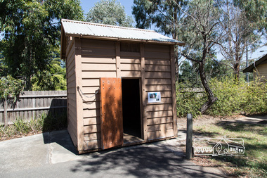
Photograph, Peter Pidgeon, Eltham Lock-up, 4 Mar 2017
This portable lock up is not original to the site. The date of construction is unknown. It is a pre-fabricated design and each of the timber panels are individually numbered on the inside surfaces. It is amongst a large group of portable locks up, categorised as 'Portable Lock Up - Timber - Later' and also known as the "Casterton style", based on the only known plan for portable lock ups, built for the Casterton Police Station, in 1907. The later portables have been in use since the 1880s. It is not known how many lock ups of this type have been constructed in Victoria. At least 50 examples have been documented around the state. Of these, 42 are known to be extant. This lockup used to be located at the Police Station in Pryor Street and was then stored in Youth Road before being acquired for the Local History Centre in 2001. Lock-up No. 17 taken on the ocassion of the opening of the newly refurbished Eltham Local History Centre Open Day, 4 March 2017, Celebrating 50 years of the Society 1967-2017.Born Digitalactivities, eltham district historical society, local history centre, main road, eltham, 50th anniversary, open day, lock up, lock-up, gaol, jail -
 Kiewa Valley Historical Society
Meteorological Conditions - Bogong High Plains
The amount of rain and snow during the year and over the years was recorded regularly. This was done at several sites and was important for the building of the Kiewa Hydro Electric Scheme which involved dams, power stations and racelines.The KHES depended on accurate and detailed measurements of rain and snow on the Bogong High Plains in order to plan and construct high functioning infrastructure. Photocopy of pages re the Meteorological conditions on the Bogong High Plains including the decades from the 1930s to 1980s. Snow depths are also documented.kiewa hydro electric scheme, meteorological conditions on the bogong high plains, snow depth on the bogong high plains -
4th/19th Prince of Wales's Light Horse Regiment Unit History Room
Documents, School of Infantry, School of Infantry Seymour Syllabus and Programmes 8/58 All Weapons Course, Jan 1958
A loose leaf folder containing lesson plans etc for the School of Infantry (then at) Seymour all weapons course covering Owen Machine Carbine, rifle, Bren Light machine Gun, grenades and 2" mortarinfantry weapons training -
 Kiewa Valley Historical Society
Book - Non Fiction History, The Kiewa Story, circa 1993
This book provides in chronological order the development of the Kiewa Hydro-electricity scheme from the first concept (1911) to final construction work (1961). It covers the first attempt to utilise the power of the Victorian Alps water system. It started from a private syndicate and developed to the current State Electricity Commission of Victoria. The incentive for the Hydro scheme was to make money and not as an alternative to the carbon producing coal fired power plants. These coal fired power plants were increasing in numbers to service an ever increasing demand made by population expansion, especially in cities and large rural settlements. This demand spiraled up after World War II when there was a tremendous spike in immigration numbers due to refugees and displaced persons in Europe. The ability to utilise the untapped water provided by the winter snow fields, for a higher yield in electricity, was a powerful incentive to overcome the physical hardships in this remote Alpine region. Future power requirements may initiate the re-installation of the other two power stations(Pretty Valley and Big Hill) covered in original Scheme. This publication not only covers the development of the Kiewa Valley region with respect to population (within a socio-economical framework) but also the subtle but yet strong physical changes of a relatively pristine alpine region. The demands that an ever growing regional population places on the environment is clearly documented in print and black and white photographs. The working and living conditions of those who constructed and gave life to this hydro scheme is well documented in this book. It may be viewed as spartan now but was relevantly good at that moment in time, especially for those workers fleeing a devastated European environment. The successful planning and consideration to minimising any intrusion upon the natural alpine forests and high plains can viewed as an example (compared to the Tasmanian Hydro schemes) of how future hydro schemes (an inevitable requirement) will proceed. Most rural towns (in the early 1900s) were built by unencumbered rural based citizens, with the exception of Mount Beauty and Falls Creek. These two settlements were brought into life by a State (Victorian) Authority for a specific function and program. They were a gated community, that is, only open to construction workers involved with the hydro scheme. All facilities within these communities were provided by the State Electricity Commission of Victoria. The impact on the social, financial and individual independency of the community, by the transition from the S.E.C .environment to one of local government (Shire of Bright), had in some cases a severe impact.This hard covered book has a green cover with pictures on the front and back covers. The front cover has a coloured picture of a snow covered Mount Bogong taken from the opposite mountain range. The valley between both ranges has a whisk of mist over it. At the bottom of this picture are three black and white photographs covering the construction of the Kiewa Hydro - Electricity Scheme. On the back cover is a photograph, (black and white) detailing the Bogong village and Junction dam containing lake Guy. The inside front cover is a black and white photograph which details the construction of the West Kiewa tailrace tunnel during April 1951. The inside back cover is a black and white photograph of the concrete pour at the Clover Dam circa 1952. All photographs and sketches are in black and white. The pages are approximately 160 g/m2 and those which have photographs are on gloss paper.Book spine: "The Kiewa Story Graham Napier Geoff Easdown" alongside this is a white framed circle with white spokes radiating out and underneath in white lettering SECkiewa valley, hydro scheme, victorian alpine region, electricity generators, graham napier, geoff easdown -
 Eltham District Historical Society Inc
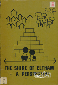
Book, Shire of Eltham, The Shire of Eltham - A Perspective, July 1981
This report was produced by the Shire of Eltham (Planning Department) following a population study of the Shire. It also includes other areas of general interest. The Document contents includes Present and Future - Population - Housing - Residential Lands - Social Characteristics - Development and History. Includes maps, tables and diagrams. Part 1: The Existing situation - introduction, the Shire of Eltham, physical characteristics, historical development, population growth. Characteristics of the population - size and distribution, age / sex, natural increase, migration. Socio-Economic Factors: socio-economic status, employment/workforce, education, other social factors. Housing/ building statistics: characteristics of Housing stock, current residential trends, other types of building activity. Residential Land: existing vacant lots, estimated additional lots. Part 2: The Future. Land availability, the future population.The Shire of Eltham Council resolved on publication of this report "to commend it to the ratepayers as a most valuable resource document". It provides a comprehensive statistical review of the Shire of Eltham, Victoria in 1981 with some population and development predictions for the future.Spiral bound, soft cover, includes indexBarcode and identification markings including stamped "WITHDRAWN" from Heidelberg Regional Library Serviceshire of eltham, planning, population -
 Warrnambool and District Historical Society Inc.
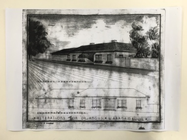
Document, Dr Angus residence plans, 1939
... Angus residence plans Document ...These are plans for alterations to the residence and surgery of Dr Angus in Koroit Street, Warrnambool (Birchwood). Dr William Roy Angus (1901-1970), after several years practising as a doctor in South Australia and northern Victoria, came to Warrnambool in 1939, purchasing the practice of Dr John Hunter Henderson (Birchwood). Dr Angus was a dominant figure in medical and community circles in Warrnambool for 30 years, becoming an important ophthalmologist in his later years. Birchwood, with its beautiful gardens, lawns and tennis court was suitable for entertaining and many distinguished people, including Vice-Regal personnel and representatives of the Red Cross stayed at the house. It was also a meeting place for representatives of the many organizations with which Dr Angus was associated (over 20 groups including the Good Neighbour Council, the Boys’ Club, the Food For Britain appeal, the Historical Society, Rostrum and the National Fitness Council). Birchwood or earlier buildings on the site was used as a residence/surgery by many doctors in Warrnambool, going back to the 1860s and Dr Angus and his family lived there from 1939 to 1967. In 1998 Birchwood was demolished and a new Warrnambool Police Station was built on the site. These plans are of interest as they show the 1939 alterations to the building known as Birchwood in Koroit Street Warrnambool. We have a good floor plan and a drawing of the front of the building so we know what it looked like in the late 1930s. Both Birchwood and Dr Angus are important in Warrnambool’s history. These are four sheets showing alterations for the residence of Dr Angus (Birchwood) in Koroit Street Warrnambool. One sheet shows the front of the house in colour drawn in ink and pencil and paint and there is a copy of this in black and white. The other drawing is of the plans for the house drawn in pencil and ink and with some red and blue colouring. There is another exact copy of this sheet. dr william roy angus, birchwood, history of warrnambool