Showing 5803 items
matching record of work
-
 Orbost & District Historical Society
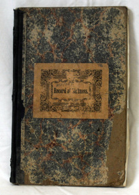
book, Record of Sickness, 1900
This book was used by the Orbost Manchester United Independent Order of Oddfellows. Friendly Societies were founded in the Australian Colonies in the mid-19th Century by immigrants from England who had been members in Societies which dated back to the 18th Century. Like all working people these immigrants experienced sickness, accidents, unemployment, death and burial. They needed help of like fellows to tide their families over these times. So they formed a branch of one of the Friendly Societies back in the mother country. The idea was to make fixed contributions to a fund and when they were off work they would receive a payment. When they died funeral benefits would be paid and the widow and children would be cared for. It was a form of local insurance for hard times. This record book was created in a time of 'look after yourself' as the Colonial Governments did not provide pensions or benefits. This item reflects those times.A hard back book with a red and blue mottled cover and a dark blue spine. On the front cover is a large brown rectangular label with "Record of Sickness" in black print inside an ornate black frame.on label - handwritten above title - "M.U.I.O.O.F."m.u.i.o.o.f. friendly-societies book-keeping -
 Ringwood and District Historical Society
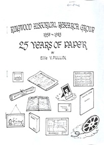
Literary work - Typed Documents, Pullin, Ellie, Ringwood Historical Research Group 25 Years of Paper 1958-1983 by Ellie Pullen - Manuscripts and Drafts (Foolscap and A4). See VC Record 4591 for pdf of printed book
Typed draft and full manuscript of the booklet 25 Years of Paper - Ringwood HIstorical Research Group 1958-1983" by E. Pullin. Also duplicate copies of the printed book -
 Australian Commando Association - Victoria
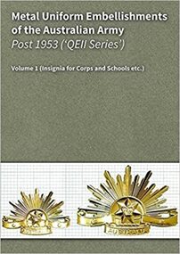
Metal Uniform Embellishments of the Australian Army Post 1953 Volume 1 - Insignia for Corps and Schools, 2017
This 236 page, full-colour hard copy reference work, catalogues the metal insignia embellishments used by all Corps and Schools of the Australian Army (including philanthropic organisations), from 1953 through to the present. The book provides images of the front and the back of a given (metal) insignia set for each Corps etc. Each image set depicts the relevant hat badge, collar badges and epaulette title and/or cloth shoulder title applicable. The book's images record three distinctly different 'generations' of insignia manufacturing methods/types, including the: gilt brass and white metal items used in the 1953 to 1964 period; and anodised aluminium 'StayBright' insignia introduced as from 1964[ and 'BriteShine' insignia introduced with effect from 1997 (running through to the present). The full colour photographic images in the book are complimented by written descriptions which cite each item's distinguishing characteristics... including measures of: typical weight, height, width and thickness (at a given point). A discussion of copies and faked items is also provided, including microscope resolution images of 'tell tale' signs to look for. The entries in the book are organised alphabetically and match those used in the Authors' 614 page eBook version of this work (the eBook is a separate edition which provides scalable images of all relevant insignia and many manufacturing variants).The hard copy and electronic editions of this work are able to be used either separately or concurrently, as and when users require. Regards Mark Corcoran & Arthur Butler The Authors charlibravobooks.com Re: Copyright As the original authors we hold the sole copyright authority to sell this work. This item does not infringe on any copyright, trademark and/or intellectual property rights and we hold specific written publication approval from the Australian Defence Force. Soft cover, spiral bound 235 pagesaustralian army, post ww2 insignia -
 Orbost & District Historical Society
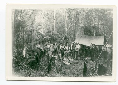
black / white photograph, 1897
Link with item 1178. This is a surveyors' camp in the McCulloch Ranges, Murrangowar, April, 1897. Included in the photograph are: L. Thorn; Pearson; L. Coburn, Clem Bates; Sam Blacklock with a packhorse. They were surveying for a road or railway. Surveyors were among the first European settlers to arrive in Australia. A Surveyor-General was present on the First Fleet, as well as the first two ships which landed in South Australia. These men were issued with instructions to record observations in a journal that included the country’s general appearance, its soil, flora and fauna and the customs and language of local inhabitants. The conditions they worked in were harsh and they embarked on journeys with drays carrying cumbersome surveying and camping equipment, spending months camping out in the bush and mapping the land. It was not until well into the second half of the nineteenth century that the professional training of surveyors became mandatory in Australia.This is a pictorial record of a surveyors' camp in the late 19th century.A black / white photograph of a group of men standing in front of a tent / camp in a dense bush setting.surveyor's-camp-mccullochs-ranges-murrangowar land-settlement -
 Orbost & District Historical Society
black and white photographs, 1890s
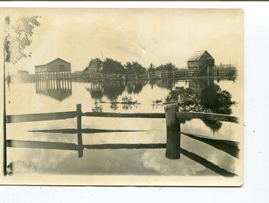
Peter Cameron, came to Orbost in 1885, at the age of 69, having sold his farm at Geelong. Peter bought the property ―Glen Avon from a Mr Street. The home was situated at the bottom of the paddock, near the corner of Morley and Livingstone streets. The farm stretched from Tennyson Street to the end of Snaggers Lane and along the river frontage to “Carinya” Cameron Home. In the Gippsland Times on Wednesday. 2 Jul 1890 on Page 3 is an article titled "THE SNOWY RIVER CALAMITY" which describes an ".unexpectedly sudden rush of water down the flats..... the terrified people commenced to remove their stock from the land and the work of saving property was continued all day ............ many head of cattle were washed away.......The river road, for its entire length, is obliterated, and the approaches to the bridge at Watt's Gulch are gone, with the enormous volume of flood water," These photographs are pictorial records of a significant event in the history of Orbost. There are few personal records of the very early floods.Three black / white photographs of wooden buildings with flood water in foreground. There are post and rail fences. 3193.2 has been taken from a distance.on back -" "Glenavon east of Lagoon 1897 Feb"floods-orbost-1890s glenavon-orbost -
 Orbost & District Historical Society
ledgers, Prescription Book, 1953 - 1984
The chemist made an entry for each prescription for medicine that was given to a customer, and the date presribed. This entry was a handy reference for repeat prescriptions. Chemists who worked in Orbost included Henry Cottman; James Alfred Dubois Williams; Harry Arthur Murray; Miss P.E .Mason (Phyllis Estelle?); Miss Sybil Monica Buzza; Thomas James Frayer; Australia Shaw; James David Torley; John William Zimmer; Dalkeith William Steele; William Thomas Hollingsworth; E.E. Cohen; R.S. Anderson; Frances John Perry Faith Everard Pardew and Charles Anthony Wurf.These books have a clear association with Orbost. They provide a record of the ailments treated by the chemists over its long history, and the types of remedies used to treat them. They show the evolution of therapeutics and the development of diverse treatments The books are interesting in giving the names of the people who came to the shop and for the prevalence of diseases that were being treated. Sixteen ledgers to record prescriptions. Information details of patients' names, medications and prescriptions are hand-written. Details of individual ledgers are in catalogue folder.orbost-pharmacies medicine drugs prescription -records -
 Orbost & District Historical Society
black and white photograph, early 20th century
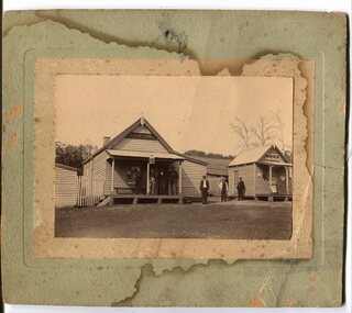
The hotel at Bonang was also known as Clancy's Hotel, Bonang, after its licensee, William Clancy. It operated from the late 1890s until early 20th century. William Clancy was aslo the postmaster at Bonang. A post office operated at Bonang from at least 1859. At the time Bonang was "a small, scattered collection of buildings marking the intersection of the Bonang Highway and the McKillops Bridge Road" ( from Regional Heritage Assessment 1996). As the mining activity declined the township became even smaller as many of the population moved to Orbost,, a larger settlement. This is a pictorial record of Bonang, a small settlement approximately 50 km north of Orbost. The buildings in the photograph no longer exist.A black / white photograph mounted on grey card. there are stains from water damage on the mount. It is a photograph of two single-storeyed timber buildings fronting a wide dirt road. On the right is the Bonang Hotel with four men in suits standing on a verandah. The building on the right is the Bonang Post Office and there are three men outside it. the photograph has been posed. on back - 'Grandma Clancy owned the hotel & Uncle Will had a gold mine which he worked"bonang bonang-post-office bonang-hotel clancy-william clancy's-hotel-bonang -
 Orbost & District Historical Society
black and white photographs, February 17 1971
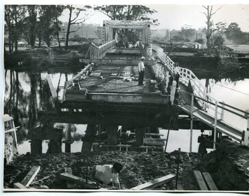
After the damage from the February 1971 floods at Orbost when the abutment to the Snowy River road bridge was washed away a Bailey bridge, portable, pre-fabricated, truss bridge, was put into place to ensure town access, the C.R.B. rebuilt the approach to the bridge driving new piles and constructing the Bailey bridge. They worked late into the night under flood lights to ensure the link from the Orbost township to the Princes Freeway would be open to traffic as soon as possible.These photographs are pictorial records of a significant event in the history of Orbost.Three black / white photographs of a Bailey bridge being erected across a river. 3245.1 and 3245.2 are the same. bailey-bridge orbost-snowy-river-bridge bridge-orbost -
 Orbost & District Historical Society
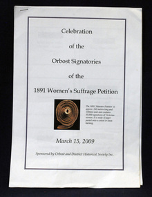
document, Celebration of the Orbost Signatures of the 1891 Women's Suffragette Petition, 2009
In 1891, Premier James Munro said he would introduce a bill into parliament for women's suffrage if it were demonstrated that ordinary women wanted this right. The Victorian Woman's Temperance Union and the Victorian Women's Suffrage Society took up the challenge, joining forces to organise a petition. Embarking on a door knocking campaign across Victoria they collected about 30,000 signatures in six weeks. The 'Monster Petition' is housed at the Public Records Office Victoria where a purpose-built perspex case protects the 260 metres of signed pages glued to sewn swathes of calico. (ref. Creative Victoria). In 2008 the petition was a centrepiece of the centenary celebrations of women's suffrage. This document was prepared for that centenary celebration.The Women's Suffrage Petition (1891) reflects the dedicated work of those women, who went from door to door across Victoria to collect the signatures. Its tremendous length earned it the name of the ‘Monster Petition'. This document is a useful research item.A stapled 9 pp document containing names, photographs, signatures of the Orbost women who signed the petition for Women's Suffrage in 1891.women's-suffrage-orbost -
 Ringwood and District Historical Society
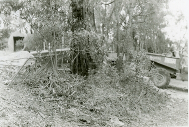
Photographs, 1979-80 MMBW pipe line project at Hubbard Reserve, North Ringwood � Boring mole pit
E560 N5 Dec 1979 A43 Boring mole pit near big box tree in 39 Burlock Avenue backyard Part of a 43-photo record of the MMBW�s engineering feat in drilling a 12 inch pipe line up to 40 feet deep through rock hardened by volcanic action associated with geological fault that occurs along the line. The work took place from October 1979 to May 1980 on the southern boundary of Hubbard Reserve, North Ringwood. The collection was presented to the Ringwood Historical Research Group by J Clarke on 9th June 1980. -
 Ringwood and District Historical Society
Photographs, 1979-80 MMBW pipe line project at Hubbard Reserve, North Ringwood � Back-hoe at pit
E560 N6 Dec 1979 A43 The back-hoe works on the beginnings of pit in 39 Burlock Avenue backyard Part of a 43-photo record of the MMBW�s engineering feat in drilling a 12 inch pipe line up to 40 feet deep through rock hardened by volcanic action associated with geological fault that occurs along the line. The work took place from October 1979 to May 1980 on the southern boundary of Hubbard Reserve, North Ringwood. The collection was presented to the Ringwood Historical Research Group by J Clarke on 9th June 1980. -
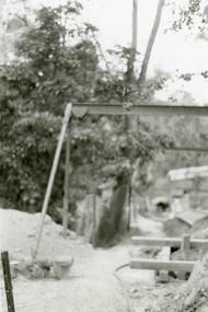
 Ringwood and District Historical Society
Photographs, 1979-80 MMBW pipe line project at Hubbard Reserve, North Ringwood � Cover of mole pit
E560 N24 Jan 1980 A43 Cover of mole pit near big box tree in 39 Burlock Avenue backyard Part of a 43-photo record of the MMBW�s engineering feat in drilling a 12 inch pipe line up to 40 feet deep through rock hardened by volcanic action associated with geological fault that occurs along the line. The work took place from October 1979 to May 1980 on the southern boundary of Hubbard Reserve, North Ringwood. The collection was presented to the Ringwood Historical Research Group by J Clarke on 9th June 1980. -
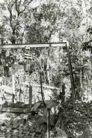
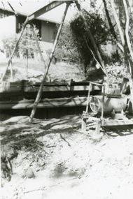
 Ringwood and District Historical Society
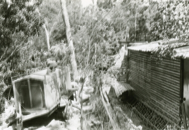
Photographs, 1979-80 MMBW pipe line project at Hubbard Reserve, North Ringwood � Compressor unit in backyard
Part of a 43-photo record of the MMBW�s engineering feat in drilling a 12 inch pipe line up to 40 feet deep through rock hardened by volcanic action associated with geological fault that occurs along the line. The work took place from October 1979 to May 1980 on the southern boundary of Hubbard Reserve, North Ringwood. The collection was presented to the Ringwood Historical Research Group by J Clarke on 9th June 1980.E560 N23 Jan 1980 A43 Compressor unit in backyard of 39 Burlock Avenue -
 Ringwood and District Historical Society
Photographs, 1979-80 MMBW pipe line project at Hubbard Reserve, North Ringwood � Work on boring mole pit
Part of a 43-photo record of the MMBW�s engineering feat in drilling a 12 inch pipe line up to 40 feet deep through rock hardened by volcanic action associated with geological fault that occurs along the line. The work took place from October 1979 to May 1980 on the southern boundary of Hubbard Reserve, North Ringwood. The collection was presented to the Ringwood Historical Research Group by J Clarke on 9th June 1980.E560 N22Jan 1980 A43 Work on mole boring pit in 39 Burlock Avenue backyard -
 Ringwood and District Historical Society
Photographs, 1979-80 MMBW pipe line project at Hubbard Reserve, North Ringwood � Filling at 29 Burlock Avenue
Part of a 43-photo record of the MMBW�s engineering feat in drilling a 12 inch pipe line up to 40 feet deep through rock hardened by volcanic action associated with geological fault that occurs along the line. The work took place from October 1979 to May 1980 on the southern boundary of Hubbard Reserve, North Ringwood. The collection was presented to the Ringwood Historical Research Group by J Clarke on 9th June 1980.E560 N10 Dec 1979 A43 Filling at 29 Burlock Avenue -
 Ringwood and District Historical Society
Photographs, 1979-80 MMBW pipe line project at Hubbard Reserve, North Ringwood � Filling behind 29 Burlock Avenue just off sewer line
Part of a 43-photo record of the MMBW�s engineering feat in drilling a 12 inch pipe line up to 40 feet deep through rock hardened by volcanic action associated with geological fault that occurs along the line. The work took place from October 1979 to May 1980 on the southern boundary of Hubbard Reserve, North Ringwood. The collection was presented to the Ringwood Historical Research Group by J Clarke on 9th June 1980.E560 N9 Dec 1979 A43 Filling behind 29 Burlock Avenue just off sewer line -
 Ringwood and District Historical Society
Photographs, 1979-80 MMBW pipe line project at Hubbard Reserve, North Ringwood � Filling at 29 Burlock Avenue
Part of a 43-photo record of the MMBW�s engineering feat in drilling a 12 inch pipe line up to 40 feet deep through rock hardened by volcanic action associated with geological fault that occurs along the line. The work took place from October 1979 to May 1980 on the southern boundary of Hubbard Reserve, North Ringwood. The collection was presented to the Ringwood Historical Research Group by J Clarke on 9th June 1980.E560 N11 Dec 1979 A43 Filling at 29 Burlock Avenue -
 Ringwood and District Historical Society
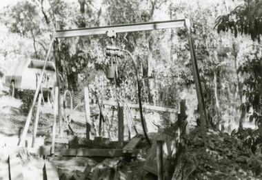
Photographs, 1979-80 MMBW pipe line project at Hubbard Reserve, North Ringwood � Closeup of revolving airwinch near Hibberd's house
Part of a 43-photo record of the MMBW�s engineering feat in drilling a 12 inch pipe line up to 40 feet deep through rock hardened by volcanic action associated with geological fault that occurs along the line. The work took place from October 1979 to May 1980 on the southern boundary of Hubbard Reserve, North Ringwood. The collection was presented to the Ringwood Historical Research Group by J Clarke on 9th June 1980.E560 N31 Jan 1980 A43 Closeup of revolving airwinch near Hibberd's house -
 Ringwood and District Historical Society
Photographs, 1979-80 MMBW pipe line project at Hubbard Reserve, North Ringwood � Grating over hole in Chalkley's 41 Burlock Avenue
Part of a 43-photo record of the MMBW�s engineering feat in drilling a 12 inch pipe line up to 40 feet deep through rock hardened by volcanic action associated with geological fault that occurs along the line. The work took place from October 1979 to May 1980 on the southern boundary of Hubbard Reserve, North Ringwood. The collection was presented to the Ringwood Historical Research Group by J Clarke on 9th June 1980.E560 N25 Jan 1980 A43 Grating over hole 37 feet deep in Chalkley's 41 Burlock Avenue (lot 8) -
 Ringwood and District Historical Society
Photographs, 1979-80 MMBW pipe line project at Hubbard Reserve, North Ringwood � View along line work in Hibberd's and Chalkley's
Part of a 43-photo record of the MMBW�s engineering feat in drilling a 12 inch pipe line up to 40 feet deep through rock hardened by volcanic action associated with geological fault that occurs along the line. The work took place from October 1979 to May 1980 on the southern boundary of Hubbard Reserve, North Ringwood. The collection was presented to the Ringwood Historical Research Group by J Clarke on 9th June 1980.E560 N27 Jan 1980 A43 View along line work in Hibberd's and Chalkley's (lot 9 and 8) -
 Ringwood and District Historical Society
Photographs, 1979-80 MMBW pipe line project at Hubbard Reserve, North Ringwood � Truck-mounted posthole digger that tried to sink shafts on MMBW sewer line behind 29-39 Burlock Avenue
Part of a 43-photo record of the MMBW�s engineering feat in drilling a 12 inch pipe line up to 40 feet deep through rock hardened by volcanic action associated with geological fault that occurs along the line. The work took place from October 1979 to May 1980 on the southern boundary of Hubbard Reserve, North Ringwood. The collection was presented to the Ringwood Historical Research Group by J Clarke on 9th June 1980.E560 N32 Feb 1980 A43 Truck-mounted posthole digger that tried to sink shafts on MMBW sewer line behind 29-39 Burlock Avenue. Four feet wide, the auger could only go down one metre and was nearly useless. -
 Ringwood and District Historical Society
Photographs, 1979-80 MMBW pipe line project at Hubbard Reserve, North Ringwood � View behind no. 39 Burlock Avenue showing compressor, mole pit cover and the big box tree
Part of a 43-photo record of the MMBW�s engineering feat in drilling a 12 inch pipe line up to 40 feet deep through rock hardened by volcanic action associated with geological fault that occurs along the line. The work took place from October 1979 to May 1980 on the southern boundary of Hubbard Reserve, North Ringwood. The collection was presented to the Ringwood Historical Research Group by J Clarke on 9th June 1980.E560 N26 Jan 1980 A43 View behind no. 39 Burlock Avenue showing compressor, mole pit cover and the big box tree -
 Ringwood and District Historical Society
Photographs, 1979-80 MMBW pipe line project at Hubbard Reserve, North Ringwood � Line of sewer work with mole power pack near Hibberd's shed
Part of a 43-photo record of the MMBW�s engineering feat in drilling a 12 inch pipe line up to 40 feet deep through rock hardened by volcanic action associated with geological fault that occurs along the line. The work took place from October 1979 to May 1980 on the southern boundary of Hubbard Reserve, North Ringwood. The collection was presented to the Ringwood Historical Research Group by J Clarke on 9th June 1980.E560 N28 Jan 1980 A43 Line of sewer work with mole power pack near Hibberd's shed -
 Ringwood and District Historical Society
Photographs, 1979-80 MMBW pipe line project at Hubbard Reserve, North Ringwood � View east, sewer work line showing grate over pit
Part of a 43-photo record of the MMBW�s engineering feat in drilling a 12 inch pipe line up to 40 feet deep through rock hardened by volcanic action associated with geological fault that occurs along the line. The work took place from October 1979 to May 1980 on the southern boundary of Hubbard Reserve, North Ringwood. The collection was presented to the Ringwood Historical Research Group by J Clarke on 9th June 1980.E560 N30 Feb 1980 A43 View east, sewer work line showing grate over pit -
 Ringwood and District Historical Society
Photographs, 1979-80 MMBW pipe line project at Hubbard Reserve, North Ringwood � Air winch over the hole in the corner of Chalkley's
Part of a 43-photo record of the MMBW�s engineering feat in drilling a 12 inch pipe line up to 40 feet deep through rock hardened by volcanic action associated with geological fault that occurs along the line. The work took place from October 1979 to May 1980 on the southern boundary of Hubbard Reserve, North Ringwood. The collection was presented to the Ringwood Historical Research Group by J Clarke on 9th June 1980.E561 N1 Feb 1980 A43 Air winch over the hole in the corner of Chalkley's (lot 8) -
 Ringwood and District Historical Society
Photographs, 1979-80 MMBW pipe line project at Hubbard Reserve, North Ringwood � Swivel crane over first hole west of boring pit in 39 Burlock Avenue
Part of a 43-photo record of the MMBW�s engineering feat in drilling a 12 inch pipe line up to 40 feet deep through rock hardened by volcanic action associated with geological fault that occurs along the line. The work took place from October 1979 to May 1980 on the southern boundary of Hubbard Reserve, North Ringwood. The collection was presented to the Ringwood Historical Research Group by J Clarke on 9th June 1980.E561 N3 Feb 1980 A43 Swivel crane over first hole west of boring pit in 39 Burlock Avenue. The track used to reach Burlock Avenue on left. -
 Ringwood and District Historical Society
Photographs, 1979-80 MMBW pipe line project at Hubbard Reserve, North Ringwood � View along MMBW work line in east end of Hibberd's, showing grating over mole boring pit
Part of a 43-photo record of the MMBW�s engineering feat in drilling a 12 inch pipe line up to 40 feet deep through rock hardened by volcanic action associated with geological fault that occurs along the line. The work took place from October 1979 to May 1980 on the southern boundary of Hubbard Reserve, North Ringwood. The collection was presented to the Ringwood Historical Research Group by J Clarke on 9th June 1980.E560 N29 Feb 1980 A43 View along MMBW work line in east end of Hibberd's, showing grating over mole boring pit -
 Ringwood and District Historical Society
Photographs, 1979-80 MMBW pipe line project at Hubbard Reserve, North Ringwood � First hole in Lot 8
Part of a 43-photo record of the MMBW�s engineering feat in drilling a 12 inch pipe line up to 40 feet deep through rock hardened by volcanic action associated with geological fault that occurs along the line. The work took place from October 1979 to May 1980 on the southern boundary of Hubbard Reserve, North Ringwood. The collection was presented to the Ringwood Historical Research Group by J Clarke on 9th June 1980.E561 N2 Feb 1980 A43 Final hole in lot 8 (no. 41) at the corner of Chalkly's -
 Ringwood and District Historical Society
Photographs, 1979-80 MMBW pipe line project at Hubbard Reserve, North Ringwood � Boring hole in lot 7
Part of a 43-photo record of the MMBW�s engineering feat in drilling a 12 inch pipe line up to 40 feet deep through rock hardened by volcanic action associated with geological fault that occurs along the line. The work took place from October 1979 to May 1980 on the southern boundary of Hubbard Reserve, North Ringwood. The collection was presented to the Ringwood Historical Research Group by J Clarke on 9th June 1980.E561 N4 Feb 1980 A43 The boring hole, 39' deep, at lot 7 (Clarke's, 39 Burlock Ave) with the generator used to supply light. -
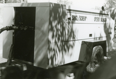 Ringwood and District Historical Society
Photographs, 1979-80 MMBW pipe line project at Hubbard Reserve, North Ringwood � compressor
Part of a 43-photo record of the MMBW�s engineering feat in drilling a 12 inch pipe line up to 40 feet deep through rock hardened by volcanic action associated with geological fault that occurs along the line. The work took place from October 1979 to May 1980 on the southern boundary of Hubbard Reserve, North Ringwood. The collection was presented to the Ringwood Historical Research Group by J Clarke on 9th June 1980.E561 N6 Feb 1980 A43 Compressor of the tunnelling gang on the sewer line in Burlock Ave